Walk #844: A linear walk from Milford-on-Sea to Christchurch
 |
 |
|
General Data
| Date Walked | 08/03/2010 |
| County | Hampshire |
| Start Location | Milford-on-Sea |
| End Location | Milford-on-Sea |
| Start time | 08.55 |
| End time | 15.40 |
| Distance | 16.5 miles |
| Description | This was a very pleasant linear walk along the coast from Milford on Sea, following routes along the clifftops or along the beach. |
| Pack | Today I carried my 30-litre Karrimor rucksack, filled with waterproofs, a book and other odds and ends. |
| Condition | My feet are totally shot after this walk; I have blisters on several toes and my heel. The last few miles proved to be a bit of a slog; not due to the terrain, but due to my lack of condition. |
| Weather | The weather today was beautifully clear and sunny, with not much breeze to chill. |
| OS map | Landranger number 196 (The Solent & The Isle of Wight, Southampton & Portsmouth) and Landranger number 195 (Bournemouth & Purbeck, Wimborne Minster & Ringwood) |
 |
 |
|
 |
 |
|
Map of the walk
Maps courtesy of Google Maps. Route for indicative purposes only, and may have been plotted after the walk. Please let me have comments on what you think of this new format. For a detailed table of timings for this walk, please see the table file.
 |
 |
|
 |
 |
|
Notes
I felt like a bit of a cheer-up, and nothing cheers me up more than a walk along the coast. Since I moved down to Hampshire a couple of years ago I have walked various sections of the coast, retracing the steps of my coastal walk. There were only a few sections between Bognor Regis in the west and Weymouth in the east that I had yet to walk, and one was between Milford on Sea and Christchurch in Hampshire. As this would be a coastal walk, I decide to do it. It took me much longer than I expected to reach Milford on Sea, and when I pulled up I was dismayed to find that it would cost me about five pounds to park for the day (before March 1st it would have been free).
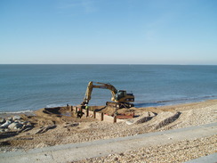
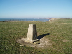
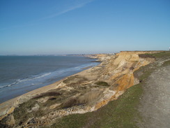
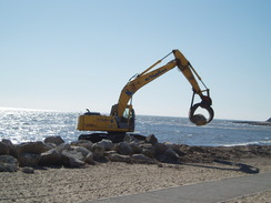
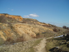
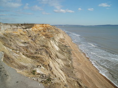
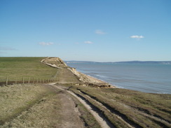
A digger and some men were repairing one of the wooden groynes, and I watched them work as I got my kit together. The initial part of the route took me along a good, high-quality path. Ahead I could see as far as the start of the South West Coast Path, and the white chalk cliffs around Old Harry Rocks shone in the early-morning sunshine. It was a glorious day, and the views across to the Isle of Wight and the Needles were also good. The promenade became a firm path, the grassy as it headed up and over Hordle Cliff. I passed a trig pillar and continued on along what was a glorious stretch of coastal walking; nice and easy, with no real gradients and good views. The cliffs were spectacular when I got glimpses of them, as was the rate of erosion - in one place there was a modern concrete manhole sticking up out of the cliffs.
At Beckton Bunny (a stream that cuts through the cliffs) a footbridge that is not marked on the map leads over the stream, and a path continues on along the top of the cliffs. After a shirt distance the path entered Barton on Sea; a seaside town that did not really grab my attention. I nipped into a shop to buy a few snacks, and then headed on, sometimes following the road that paralleled the coast and sometimes the grassy paths alongside the top of the cliffs. It was a pleasant walk, but unfortunately my feet were starting to hurt me. I have been having trouble with my feet this year and, to try and ease the problems, was wearing two layers of socks. I have not had to do this for years, but as I walked it became obvious that it was not solving the problems.
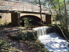
The path along the coast is blocked at the Naish Holiday village, and so I had to divert off up to the main road to get past it. Initially a narrow path took me alongside the fence of the village, but this soon dropped me off into an area of housing. I went wrong on a couple of occasions, but after asking a king lady I found myself on the narrow pavement beside the busy A337 road. Fortunately I only had to follow it for a short distance, and when a bridge over a stream is reached took a path that headed back towards the sea. This soon became a fairly pleasant wooded walk through Chewton Bunny; very enjoyable.
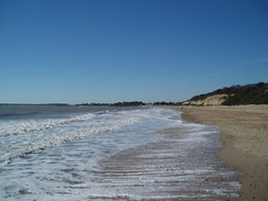
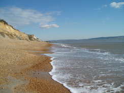
This burst out into the sunlight on the coast, and I started heading westwards once more. A good, firm path led me onwards, and this stretch was far busier than the previous ones today. I had a choice here; I could walk along paths across the top of the cliffs past Highcliffe Castle, but instead I decided to stick to the beach. Soon the path ended and I had to walk along the shingle; I walked down and walked through the surf, reveling in getting my boots wet in the sea once again.
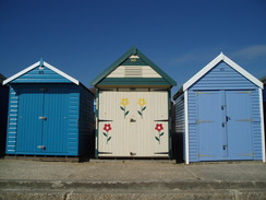
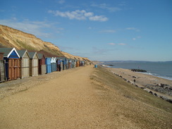
A path restarted near some beach huts, and it was good to see a fair few people out and about maintaining and painting them. Although they are not really for me (at least at my age), I quite like the idea of beach huts - and the loving care being put into some of them shows that they are popular. Indeed, a little further on some beach huts were being assembled from a flat-pack assembly on a trolley - I wonder if Ikea are going to get into the beach hut market?
Eventually the mouth of Chichester Harbour came into view and, on the other side, the sand bar that sticks up like a phallus from Hengistbury Head. I have walked that stretch on a couple of occasions, although I have never actually walked over the headland, something that I intend to correct soon. I walked around the mouth of the harbour and past the RNLI lifeboat station until a small white pub was reached. I nipped inside - the interior was small, and I settled into a darkened snug with a pint of bitter and one of orange and lemonade - my usual combination when walking. I had a book with me but could not really settle; I took my boots off and removed the first pair of socks, allowing my feet to breathe a little, even if the other customers probably could not!
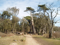
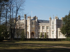
I set off once again and started heading back more or less the way I had come. Instead of following the beach to Chewton Bunny, I headed up the path that took me onto the cliffs. The path headed through Steamer Point nature reserve (so called because a steamer was once beached below the cliffs), and it was a pleasant walk. The gates to the reserve appear to be locked at night, so be careful if you are doing this walk at strange times of the day. After this I got a glimpse of Highcliffe Castle itself - a splendid nineteenth-Century Gothic revival building. Shortly after this I took a long, zig-zag path that led me down to the beach.,
Instead of heading back along Chewton Bunny, I decided to continue along the beach. As I walked I chatted to a man who was out looking for prehistoric shark's teeth - apparently they are a common find along this stretch of the beach. The cliffs in this area consist of several slumped levels, the result, not of erosion by the sea, but of water getting between layers of the rock and causing falls. This causes the teeth in the rock to get washed out onto the beach. We both looked down at our boots as we walked, but there was nothing to be seen.
I decided to continue along the beach, and although forced to divert over a rough area of slumped cliff below Barton on Sea, I was soon passing some more beach huts. A good path took me onwards to some rock rip-rap, which the wave lashing around the base. A man ahead of me turned back here, but I continued on, carefully crossing over the rip-rap and accessing the beach on the other side. My feet were rally aching by now, and the shingle did not make for particularly easy walking. Therefore I chickened out from continuing along the beach to Milford on Sea, and followed a path that headed up Backton Bunny. Instead of walking to the footbridge, I crossed the little stream and struck straight up the steep valley side to access the path more directly - a silly thing to do on tired legs.
From there it was simply a case of following the path back to my car in Milford. My feet were aching a great deal now, and a couple of old ladies overtook me as I hobbled along the promenade. Still, the views over to the Needles and the Isle of Wight distracted me from the pain for some of the time. This had been a superb walk on a sunny day, although I will need to fix the problems with my feet before doing longer distances...
 |
 |
|
 |
 |
|
Directions
This walk starts off at a car park beside the sea in Milford on Sea. If the tide is low it should be possible to walk along the shingle beach all the way to Little Haven at the mouth of Christchurch Harbour. Note that there are some significant distances between access points up the cliff, so care should be taken. If the tide is high or you do not fancy a long walk on the shingle, take the route on the cliffs described here. From the car park face the sea and turn right along a little promenade westwards through the town.
The promenade ends fairly soon and the path climbs uphill along Hordle Cliff. The path continues on, passing a trig point before skirting the edge of a golf course. When a steep-sided valley is reached the map shows the footpath leading off to the right along the side of a valley called Beckton Bunny; however there is another footpath (not marked on my OS map) that heads across the valley on a bridge before skirting the cliffs and reaching Barton on Sea.
In Barton on Sea I joined a road that follows the top of the cliffs westwards. Unfortunately when the road reaches the western side of the town it meets a caravan park and curves around to the right to head northwards up to the A337 road as you cannot walk through the caravan park. When the A337 is met turn left and descend downhill to a bridge over Chewton Bundy, which marks the Hampshire / Dorset boundary.
On the other side of the bridge a footpath leads off to the left to head about a kilometer southwestwards back to the top of the cliffs. However when I first walked this route the footpath was closed due to a landslip, so I had to walk along to the first road on the left and follow this until a road leads off to the right. Naturally enough, it had reopened the second time I walked it seven years later! Follow this road and then turn left to reach a car park on top of the cliffs.
If the tide is out descend onto the beach and walked past a series of groynes westwards beneath the cliffs under Highhcliffe Castle. If the tide is high you can follow footpaths that follow the clifftop before skirting around the castle. Whichever route you take, follow the cliffs around as they slowly lower in height as they enter Christchurch and go around to Lower Haven by the lifeboat station.
To return, either go back the way you came, or walk along the beach if the tide is low.
Distances
| From | To | Distance (m) | Ascent (ft) | Descent (ft) |
|---|---|---|---|---|
| Milford on Sea | Little Haven | 8.9 | 390 | 390 |
| Little Haven | Milford on Sea | 7.6 | 630 | 630 |
This makes a total distance of 16.5 miles, with 1020 feet of ascent and 1020 feet of descent.
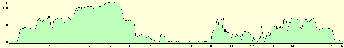
For more information on profiles, ascents and descents, see this page
 |
 |
|
Disclaimer
Please note that I take no responsibility for anything that may happen when following these directions. If you intend to follow this route, then please use the relevant maps and check the route out before you go out. As always when walking, use common sense and you should be fine.
If you find any information on any of these routes that is inaccurate, or you wish to add anything, then please email me.
All images on this site are © of the author. Any reproduction, retransmissions, or republication of all or part of any document found on this site is expressly prohibited, unless the author has explicitly granted its prior written consent to so reproduce, retransmit, or republish the material. All other rights reserved.
Although this site includes links providing convenient direct access to other Internet sites, I do not endorse, approve, certify or make warranties or representations as to the accuracy of the information on these sites.
And finally, enjoy your walking!
Nearby walks
| # | Title | Walk length (miles) |
|---|---|---|
| 310 | Bucklers Hard to Milford on Sea | 19.0 |
| 311 | Milford on Sea to Southbourne | 16.9 |
| 312 | Southbourne to Hamworthy Station | 15.3 |
|
|

|