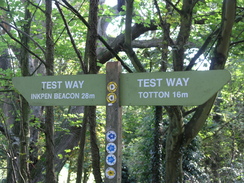
Walk #789: A circular walk from Mottisfont to Fullerton
 |
 |
|
General Data
| Date Walked | 18/10/2007 |
| County | Hampshire |
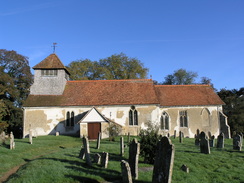
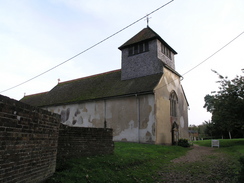
| Start Location | Mottisfont church |
| End Location | Mottisfont church |
| Start time | 09.31 |
| End time | 16.48 |
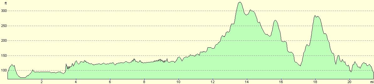
| Distance | 21.4 miles |
| Description | This was a pleasant walk following the test Way northwards from Mottisfont, before looping back along local road and footpaths. |
| Pack | Today I carried my 30-litre Karrimor rucksack, filled with waterproofs, a book and other odds and ends. |
| Condition | I feel absolutely fine after this walk, with no problems to report. |
| Weather | The weather today started off sunny but sloely clouded over as the day progrressed; it was a reasonably warm day for the time of year. |
| OS map | Landranger number 185 (Winchester & Basingstoke, Andover & Romsey) |
 |
 |
|
 |
 |
|
Map of the walk
Maps courtesy of Google Maps. Route for indicative purposes only, and may have been plotted after the walk. Please let me have comments on what you think of this new format. For a detailed table of timings for this walk, please see the table file.
 |
 |
|
 |
 |
|
Notes
I had not done any walking for a week, and I was keen to get some mileage under my belt in this new area to me. On my last walk I had done six miles of the Test Valley way, and I had already planned another circular walk following the same path northwards. Therefore after dropping Sencan off at work I drove the short distance to Mottisfont and attempted to look for somewhere to park. The main car park for the abbey was out of the village in the wrong direction, and so eventually I pulled in at a wide point in the road near the church.
It was getting quite late for starting a long walk at this time of year and therefore I hurriedly pulled all of my kit together and started off down the road. Mottisfont is a fairly pretty village and is very much a National Trust place. Almost immediately there is a large Tithe Barn beside the road, and planning signage on this stated that it was being converted into residential accommodation - I can only hope that it is done sympathetically.
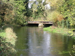
Initially my route followed the one I had taken on the last walk, but soon I passed an entrance gateway into the abbey and the road junction where I had left the Test Way. It was turning out to be a beautiful day, with bright sunshine and only patchy cloud overhead and scarcely any wind, although it was quite chilly. Soon the Test Way left the road and headed off across a field that gave occasional glimpses over to the Abbey to the right. This led on to a road and a bridge over the pretty Oakley River, before crossing another field to reach the River Test near what looked like formal gardens.
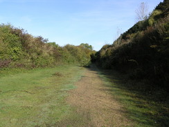
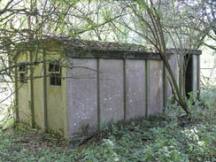
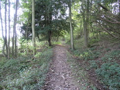
Once across the river the Way joined the old South Western Railway 'Sprat and Winkle line' that used to run from Southampton to Andover, which was built over the old Redbridge to Andover canal - as I walked there were occasional views of the old canal beside the trackbed. The line itself seemed to be quite well preserved as I walked northwards, with concrete lineside permanent way shelters still extant forty years after the line closed (they are usually demolished when the line is closed or by arson afterwards). Additionally there were patches of original ballast on the double-track formation, and the first overbridge that I reached seemed to be in reasonable condition, with paint on the underside seeming to be recently applied.
After a couple of miles the path diverted slightly to the left away from the railway trackbed, and soon I was passing the site of the old Horsebridge Station.l was overjoyed to see that this has been lovingly restored, with the signal box and station buildings (complete with canopy over the platform) freshly painted. There was a green coach in one of the platforms, and the whole site can be hired for weddings - see www.horsebridestation.co.uk for more information.
Immediately beyond the station there was a bridge over a stream - the first underbridge that I had passed - and the path rose up to meet a road at the site of an infilled overbridge. The Test Way continued along the pleasant route along the railway trackbed for another couple of miles, and there are occasional good views over Common Marsh to some hills to the west. The old railway line abruptly ended at a road that I followed northwards to a large roundabout on the A30 in Stockbridge, where the road has obviously been diverted onto the old trackbed. To my left in the village I could see a post office sign, so I nipped into the co-op attached to it to buy some crisps and chocolate.
There then followed a fairly unpleasant stretch of walk, as the Test Valley Way followed the A30 northwards for a few hundred yards. In a couple of places the verge was rather overgrown which forced me into the road, and it was a relief when a roundabout was reached and I could follow the A3057 road instead. Like the A30 this road had been realigned over the old railway trackbed, although fairly soon I found the start of the trackbed once more.
This took me northwards, and the adjacent road made its presence known on the way. It was much less of a pleasant walk than the stretch south of Stockbridge had been, although there were some things to take my interest en route - another set of concrete permanent way huts, and an overbridge that was being supported from below by large metal girders. The path passed Leckford which passed almost unnoticed, and before I knew it I was passing under a large brick viaduct that marked the approach to Chilbolton.
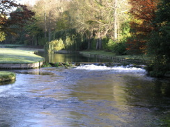
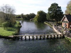
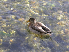
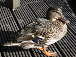
Here I decided to visit the nearby pub marked on the map, and so I used a path to get to the top of the bridge and carefully crossed it, as it was narrow and there was plenty of traffic to contend with. Once at the pub - called the Mayfly - I went in and ordered a pint of 6X and a packet of nuts before going to sit outside. The pub is in a glorious spot, with the river rushing by down a weir and lots of wildlife about. Indeed, some of the wildlife is very friendly, and ducks were walking around under my feet as I slowly sipped my pint.
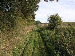
It was a pleasant spot and it seemed a shame to leave, but the day was getting on and I was under halfway through the day. Instead of walking over the narrow stretch of the bridge to regain the old railway line I decided to follow the A3057 for a short distance until the first road was reached, which put me back on my planned route. A short stretch of road allowed me to bypass Fullerton, and then a long byway headed west below Hazel Down. The ground underfoot was firm and it made for an enjoyable stroll as I passed a load of free-range chickens running around outside an area of densely-packed woodland.
The farm at Waters Down was being converted to accommodation, and I am not sure that the barns had been too tastefully done. To my eyes there seemed to be too much glass, but that may have been necessary depending on how it originally looked. There was still some work to be done on the renovation, but it seemed to be mostly there, although there were still machines scattered about lying idle.
Immediately past the farm I joined a road,and to my right were Blackstake Hill and, further on, Danebury Hill. It was tempting to go to the top of these and bag the trig pillar that lay between them, but time was pressing and we had a course to attend in the evening, The road soon ended, and another byway took me on past the eastern flank of Blackstake Hill, descending and climbing to reach the end of a road. This quiet road (not a single car passed me whilst I was on it) took me southwards, and immediately after the attractive buildings of Chattis Hill Stables the A30 was reached.
Once across the A30 another road took me on southwestwards, climbing up a short but steep hill before yet another byway took me on southwards. Again this was a pleasant, if narrow, stroll, as it headed down towards the village of Broughton. Just before this was reached a footpath carrying the Clarendon Way (a path from Winchester to Salisbury) was crossed for the second time, and there was a pleasant stone carving showing the route beside the path.
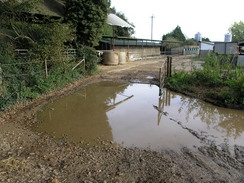
In Broughton a minor and narrow lane took me to an attractive ford over a stream, and once safely crossing this by the adjacent footbridge I followed a road uphill, which soon became a track. The map showed a footpath heading off to the left from this track and there was a suitable signpost, but as it directed me through a piggery I kept on along the track before turning along another one to rejoin the proper route on the other side. I am unsure whether the piggery has legally blocked the footpath or not, but I could not see any point in not taking the easy diversion.
The path skirted the edge of the field for a short while before starting to climb fairly steeply uphill, and as it ascended there were some pleasant views out through the trees. The path suddenly ended at a road, and as this was followed for a short distance the views were uninterrupted and good They soon ended when I took another road southwards, before joining a footpath that took me on eastwards towards Pittleworth Dairy Farm.
From here it was just a simple case of following the road southwards towards Mottisfont and my car, and to while away the time I started devising another 60-word story for my writing class. This took me over a mile, and the quiet road was almost ideal for the task until I was satisfied that the story was good enough. The road climbed and fell as it continued on, and soon it was approaching Mottisfont and rejoining the Test Valley Way, which I had walked along earlier.
My car was soon reached and I chucked my kit into the back before driving off back home to Romsey. It had been a very pleasant walk, and one that had allowed me to tick of another few miles of the Test Valley Way, a trail that I would like to complete before the end of the year. Before I do the next stage of that trail, however, I might do a couple of circular walks from Salisbury that promise to me more scenically rewarding.
 |
 |
|
 |
 |
|
Directions
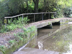
This walk starts off at Mottisfont Church, and the first part follows the Test Way. Leave the church and head a few yards down the track to the road. At the road turn left, and follow it as it curves around to the right to head northwards. At SU325273 turn right to join a footpath. Initially this heads across a field for a little under half a mile, initially eastwards before curving to the left to head northeastwards. This ends at a road immediately to the east of Oakley Farm. Turn right; the road ends and a track continues onwards, crossing a tributary of the River Test. Follow this track for a little over half a mile, until it crosses the River Test proper.
On the other side of the river bridge turn left to follow the course of an old railway line northwards as it passes through Horsebridge. After nearly five miles the path reaches a large roundabout on the A30 immediately to the east of Stockbridge. Head straight on at the roundabout, continuing on northwards along the A30. Walk on the left-hand side of the road until another roundabout is reached with the A3057. Continue straight on for a short distance, and then rejoin the old railway line on the left.
Follow the old railway line for about 2.5 miles, passing through Leckford. The path eventually passes under a large road bridge at SU382389; on the other side turn right and follow a path that goes up to join the A3057. Follow the A3057 as it heads northwestwards, passing the Mayfly pub. When there is a road junction on the left, turn left down another road. This crosses the River Anton on a bridge. When a road junction is reached shortly afterwards, turn left and follow this road 0.4 miles southwards.
At a left-hand bend in the road at SU375389, turn right to join a track. This heads westwards, before curving to the right and then the left as it heads across the bottom of Hazel Down. A mile after the road, another road is reached. Cross this, and continue on westwards along a track on the other side. This slowly curves to the left to take a more southwesterly course, eventually passing Waters Down Farm before ending at a road. Turn left down this road for a short distance until it ends at a T-junction with another road.
At this junction head straight on along another track that heads southwards, with Blackstake Hill a short distance away to the west. After 0.8 miles this track becomes a road, which heads southwards for another 0.8 miles until the A30 is reached. Cross the A30 and head on along another road for a little over half a mile; when the road curves to the right continue straight on down a track. This curves around in various directions for 1.4 miles, before settling on a more southwesterly course and ending at a road near Hayter's Farm near Broughton.
head south along this road for a short distance, crossing a ford to reach another junction. Head straight on along a road that heads uphill to the southwest; when this ends continue straight on uphill for a short distance. Then turn sharply to the left to head southeastwards for half a mile along another track until this ends a road at SU318311. Turn left to head eastwards along this road, and after a hundred yards turn right down another road.
This heads southwards for half a mile. When it ends a track continues on; follow this as it curves to the left to head eastwards, eventually passing through Pittleworth Dairy Farm to end at a road. Turn right, and start following this road southwards for a couple of miles as it enters Mottisfont and heads back towards the church.
Distances
| From | To | Distance (m) | Ascent (ft) | Descent (ft) |
|---|---|---|---|---|
| Mottisfont church | Stockbridge | 6.3 | 187 | 164 |
| Stockbridge | West Down | 3.2 | 79 | 69 |
| West Down | Bossington | 9.6 | 528 | 502 |
| Bossington | Mottisfont church | 2.3 | 105 | 164 |
This makes a total distance of 21.4 miles, with 899 feet of ascent and 899 feet of descent.
For more information on profiles, ascents and descents, see this page
 |
Disclaimer
Please note that I take no responsibility for anything that may happen when following these directions. If you intend to follow this route, then please use the relevant maps and check the route out before you go out. As always when walking, use common sense and you should be fine.
If you find any information on any of these routes that is inaccurate, or you wish to add anything, then please email me.
All images on this site are © of the author. Any reproduction, retransmissions, or republication of all or part of any document found on this site is expressly prohibited, unless the author has explicitly granted its prior written consent to so reproduce, retransmit, or republish the material. All other rights reserved.
Although this site includes links providing convenient direct access to other Internet sites, I do not endorse, approve, certify or make warranties or representations as to the accuracy of the information on these sites.
And finally, enjoy your walking!
Nearby walks
| # | Title | Walk length (miles) |
|---|---|---|
| 787 | Romsey to Eastleigh via Winchester | 21.1 |
| 788 | Romsey to Salisbury | 23.1 |
| 791 | A circular walk from Chilbolton to St Mary Bourne | 23.5 |
|
|

|