Walk #437: Parton to Allonby
 |
 |
|
General Data
| Date Walked | 09/05/2003 |
| County | Cumbria |
| Start Location | Parton |
| End Location | Allonby |
| Start time | 08.54 |
| End time | 16.39 |
| Distance | 20.2 miles |
| Description | This was quite an enjoyable walk north along the coast through Workington and Maryport. |
| Pack | Today I carried my 30-litre Karrimor HotRock rucksack, which was filled with my packed lunch, waterproof leggings, water bottle and a couple of spare shirts, together with the usual assortment of odds and ends. |
| Condition | I feel absolutely fine after this walk, and I could easily have walked further if the weather had looked fit enough. My right ankle was fine and gave me no trouble, and the biggest problem that I had was with a toe on my right foot, which gave me a bit of gip. |
| Weather | The day started off quite sunny with only a few clouds in the sky, but there was a very keen wind. As the day went on the clouds started to gather, and after I left the van in Maryport it started to rain heavily. It got much cooler (apparently it was snowing on Shap summit) and the wind blew the wind horizontally. Fortunately the wind was from behind me, so it blew me along and only my back got soaked. After I finished the walk the sun came out once again, but by this time I was firmly ensconced in Mervan. |
| OS map | Landranger number 89 (West Cumbria, Cockermouth & Wast Water) and Landranger number 85 (Carlisle & Solway Firth, Gretna Green) |
 |
 |
|
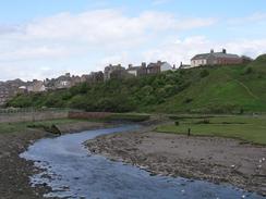 |
Map of the walk
Maps courtesy of Google Maps. Route for indicative purposes only, and may have been plotted after the walk. Please let me have comments on what you think of this new format. For a detailed table of timings for this walk, please see the table file.
Notes
I left the van this morning feeling in fine fettle, only to discover that I could not find the footpath. This is marked on the Ordnance Survey map as running on the coastal side of the railway line, but I could not find an easy way over or under the line. The path met the road a little further on, so I decided to walk along the road instead of trying to find the path. On the way I passed across a small patch of grass that a few children were using as a football field. As I strode across the grass between them they looked at me, and I announced 'pitch invasion!' at the top of my voice.
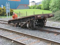
I found the steel works to the south of Workington to be quite fascinating. The first sight of the works was of old wagons turned upside down, probably ready for scrapping. The works produces much of the rails used on Britain's railways, and I was interested to see newly rolled rails stacked up outside the plant. I am very used to seeing rusty rails, but these were extremely shiny, having not been exposed to the air long enough for them to start rusting. Outside the plant were many wagons loaded up with rails, and one trainload of long continuously welded rails was being loaded. This sort of thing fascinates me, and I could get a good view of the plant from he footpath, which was elevated above the railway line. A little further on I came to a level crossing over a couple of lines that led from the works to the docks, and I saw the rather incongruous sight of a wagon minus an axle, which was in the ballast a few yards further down the track. There was a man sitting on the wagon, and apparently earlier in the day whilst transporting some rails the axle got pulled of the wagon. The man was waiting for a crane to arrive, and I must admit that I had a little chuckle at the sight of the rather ill looking wagon.
For much of today I could quite clearly make out the coast of Argyll, and in particular the 1,868-foot summit of Criffell. This is a sign of just how close I am to Scotland, although I have a long diversion to Carlisle to make first before I can cross the border. I really cannot wait to reach Scotland - it will mean that I have finished two countries (Wales and England), and the end will be in sight, albeit still a long way away.
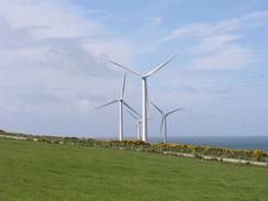
I passed three separate wind farms today, and these are quite impressive structures, particularly in today's strong winds. I passed right through the Oldfile wind farm to the north of Workington, and I could look up at the massive sails going round. This farm consists of nine turbines, and can generate 5.4 Megawatts of electricity, an amazingly large amount for such elegant structures to generate. Unfortunately it is also a small amount compare to the power that a 200 Megawatt power station can generate. I have heard that the tips of a turbine are travelling at near the speed of sound, something that seems amazing until you think of the large diameter of the sails and the speed that they travel at.
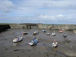
I met Sam again near the bridge over the river in Maryport, which I thought looked like a lovely little town - it is hard to believe that at one time over a million tons of cargo a year. I used the opportunity to change into my trainers, as one of my toes was hurting, and just as I was getting ready to leave it started to spit with rain. The sky did not look to threatening, so I did not bother changing back into my boots. Unfortunately about five minutes after I left it started to rain very heavily, and as I walked along the promenade north of the town it started to absolutely bucketed it down. The wind was coming from behind me, and in a couple of minutes he back of my trousers were soaked, so I nipped into a little shelter to put on my waterproof trousers. When it rained it also got much colder, and by the time I reached the van I was in need of a cup of coffee to warm myself up inside especially as I had not had a fleece on.
We sat in the van tonight and watched the sun set over the hills of Scotland to the west, the clouds going a rosy red colour which looked beautiful. One of the great things about living in a motorhome is the way that we end each day in a different place, and when I wake up in the morning and open the blinds we have a different view. The days are also getting longer at the moment, and it was still not totally dark at ten o'clock this evening, and we looked out to sea. We could see the St Bee's lighthouse flashing to the south, and the lights of a couple of towns on the Dumfries and Galloway coast to the north. We spent a while trying to identify places from their position on the coast, which was a truly magnificent few minutes.
Directions
Most of this route follows the Cumbria Coastal Way for much of the way, which helps with navigation somewhat. This walk starts off at the car park beside the station in Parton. Leave the car park and turn to the left to walk along a minor road northwards beside the railway line. This road curves to the right to cross a stream and climbs slightly uphill before ending at a T-junction. Turn to the left to climb uphill through the village of Lowca, and on the northern side of the village the road curves to head northeastwards past a wind farm. The map shows the Cumbria Coastal Way heading off to the left past Park House Farm, but fences blocked the way and I had to walk further northeastwards along the road until a track led off to the left, heading past a trig point and leading back to Park House. It looks as though the path is going to be diverted, as the construction of the wind farm has altered local routes.
When the track heads through Park House Farm turn to the right down a track that heads westwards until it meets the trackbed of an old railway line. Turn right and walk along the old trackbed northwards past Harrington Parks, before a track leads over a railway bridge and down to Hartington Harbour. Continue past the harbour and continue along a path that heads northwards with the railway line to the right. At an underbridge pass under the railway line and then follow the path northwards with the railway line to the left. The path passes the Workington steel works, and when an overbridge is reached climb up onto the bridge and then turn to the left along a road. When the road curves to the right continue straight on along a minor road across a level crossing over some railway sidings, and follow this road straight on. It crosses some more lines and then curves to the left for a short distance, before a track leads off to the right. Follow this track as it heads uphill northward over The Howe, before dropping down to reach a car park at a point to the west of Workington.
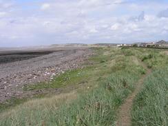
Leave the car park and then turn right down a road that follows the southern bank of the river until a railway bridge is reached. Turn to the left and cross the river on a little pedestrian bridge beside the rail bridge, and continue on until a track is met. Turn to the left down a track and then turn right down the access road to a wind farm. The path continues northwards past the wind farm before eventually heading northeastwards beside the railway line. As the tide was out I chose to walk along the beach all the way towards the town of Maryport. Just before the wall next to the marina is reached turn to the right and walk inland to a road, which can be followed northwards through the town to the bridge over the river. On the other side of the river turn left and walk through the town to the promenade beside the sea. Turn right and walk northeastwards along the promenade, and when it ends continue on along a path through the dunes between the sea and the B5300 road. Eventually the outskirts of the village of Allonby is reached and this walk ends at a car park on the southern side of the village opposite the Baywatch Hotel.
For more details of the Cumbria Coastal Way, see the excellent little book, The Cumbria Coastal Way: A Walker's Guide", by Ian and Krysia Brodie, ISBN 187355110X. This book is a lovely and detailed description of the walk, and unfortunately I did not manage to get a copy until after I finished the walk, for it would have been quite handy.
Distances
| From | To | Distance (m) | Ascent (ft) | Descent (ft) |
|---|---|---|---|---|
| Parton Station | Workington | 8.4 | 627 | 643 |
| Workington | Maryport | 6.6 | 305 | 295 |
| Maryport | Allonby | 5.2 | 171 | 174 |
This makes a total distance of 20.2 miles, with 1103 feet of ascent and 1112 feet of descent.
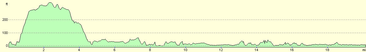
For more information on profiles, ascents and descents, see this page
Accommodation
We parked Mervan in a car park opposite the Baywatch Hotel in Allonby. This car park had some toilets in it, which was quite handy.
Disclaimer
Please note that I take no responsibility for anything that may happen when following these directions. If you intend to follow this route, then please use the relevant maps and check the route out before you go out. As always when walking, use common sense and you should be fine.
If you find any information on any of these routes that is inaccurate, or you wish to add anything, then please email me.
All images on this site are © of the author. Any reproduction, retransmissions, or republication of all or part of any document found on this site is expressly prohibited, unless the author has explicitly granted its prior written consent to so reproduce, retransmit, or republish the material. All other rights reserved.
Although this site includes links providing convenient direct access to other Internet sites, I do not endorse, approve, certify or make warranties or representations as to the accuracy of the information on these sites.
And finally, enjoy your walking!
This walk was mentioned in the following routes:
| My walk around the coastline of Britain |
Nearby walks
| # | Title | Walk length (miles) |
|---|---|---|
| 436 | Gosforth to Parton | 20.3 |
|
|

|