Walk #629: Shrewton to Warminster
 |
 |
|
General Data
| Date Walked | 23/10/2004 |
| County | Wiltshire |
| Start Location | Shrewton |
| End Location | Warminster |
| Start time | 10.00 |
| End time | 15.51 |
| Distance | 16.7 miles |
| Description | This was a long, wet slog following the Imber Range Path, which runs along the southern side of Salisbury Plain. |
| Pack | Today I carried my 30-litre Karrimor HotRock rucksack, which was filled with three litres of water, a fleece and various electronic gadgets. Because of the lousy weather I wore my waterproofs. |
| Condition | I am reasonably okay after this walk, the main problem being that when I reached Warminster I was doing a very good impression of a drowned rat. I found the walk slightly harder than I should have done, partially because I have not been doing much walking recently, but also because of the rain, which always makes walks harder. |
| Weather | Today was characterised by the continuous rain that fell all day at varying intensities. Sometimes it was light, and at others it was quite heavy. There was a slight breeze that generally blew the rain into my left side or my face, and over time this became more than a little annoying. Fortunately it was actually a reasonably warm day for he time of year, and at no time did I really feel cold. |
| OS map | Landranger number 184 (Salisbury & The Plain, Amesbury) and Landranger number 183 (Yeovil & Frome, Shaftesbury & Shepton Mallet) |
 |
 |
|
 |
Map of the walk
Maps courtesy of Google Maps. Route for indicative purposes only, and may have been plotted after the walk. Please let me have comments on what you think of this new format. For a detailed table of timings for this walk, please see the table file.
Notes
Before Sam goes back to Oz she really wanted to visit Longleat Safari Park, which she had seen on television many times over the last couple of years. Since I would rather have my eyes get bored out by a red-hot poker than go around a safari park all day, we agreed that whilst Sam was talking to all the animals I would go for a walk over the nearby Salisbury Plain, and we would spend all of Sunday together in Bath. This suited me fine, and as we set off early this morning from Cambridge the skies overhead seemed quite promising for a nice weekend out. This was particularly important, as we had cancelled the trip twice before due to unforeseen events, and both of these weekends had turned out to have nice weather.
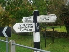
Unfortunately as we drove around the M25 the skies progressively began to darken, and, as we had feared, it was raining when we reached the start of the walk at Shrewton. Sam pulled up in the car park of the British Legion hall, and I started prevaricating in the light drizzle as I slowly packed up all my kit. Eventually I was ready to go, so I waved Sam off on the last stint of her drive to Longleat, and I headed up the A360 road. This was quite narrow and busy, and I was forced to divert into the verge fairly frequently to avoid traffic. This did give me the advantage of nipping into a courtyard to see a plaque on an attractive cottage stating that they had been built in 1842 to assist poor victims of the great flood of 1841 in the Till Valley. The plaque stated 'These cottages builded in the year of our lord 1842 from a portion of the fund subscribed by the public to repair the losses sustained by the poor of this and five neighbouring parishes in the great flood of 1841. Are vested in the name of the twelve trustees who shall let them to the best advantage and after reserving out of the rents a sum sufficient to maintain the premises in good repair shall expend the remainder in fuel and clothing and distribute the same amongst the poor of the said parishes on the 1st day of January for ever being the anniversary of that awful visitation'. The plaque touched me greatly; I found it moving that there should be such a plaque, which was written like a legal document then anything that would appear nowadays. The fund was massively successful, and ended up building fourteen cottages in the surrounding villages.
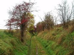
I was quite relieved when I could leave the road and start heading along a green by-way westwards, and I started to enter Salisbury Plain proper. The by-way soon diverted off to the right back towards the road, but I passed some fairly ominous military signs and continued westwards along a green track. Salisbury Plain is not an area that I have really visited before (except for a couple of drives along the A360 and other roads) and I was slightly disappointed by the relatively flat terrain. I was probably being slightly harsh on it, however, as the weather was becoming slowly worse. The wind was increasing and blowing the rain into my left-hand side. I continued walking, but it was clear that I was going to quite wet, regardless of how good my waterproofs were.
After I paused to avoid three Roe Deer close by, a quite magical moment even in the rain, I continued on and the track soon approached a collection of buildings. Just before these were reached the 30-mile long Imber Range Perimeter Path was reached, and as the path across the grass and through the bushes was unclear I followed a concrete road that skirted the area on the map, carefully listening for any military vehicles that may suddenly have come down upon me. As I approached the southern side of the village I was surprised to see that they formed a mock German village called Copehill Down, which was obviously used by soldiers to practice street fighting. It was quite an incongruous sight on the plain, and it cheered me up.
Once past the village the Perimeter Path became obvious again, and I started following this southwestwards. The path followed a distinct, although unfenced, green lane, and I was enjoying the stroll when I came across a gentleman walking his dog. In a thick West Country accent he told me that he loved the Plain, and would walk wherever he wanted as long as no red flags were flying. I had not seen a red flag (or red beacon) all day, and this is one of the annoying things about military ranges; the army do a very good job of making them available to the public when possible, but it is always hard to know exactly where and when you can walk, even with their excellent website. The lane headed downhill, joining a road for the last short stretch towards the church in Chitterne. The path joined the main road and passed a pub, on the way passing road signs warning drivers of tanks; a strange sight. The rain was falling harder now, and it felt like a very good idea to go in for a drink. Unfortunately although there were lights on inside the pub it did not look very open, so I trudged on along the road.
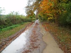
The road was soon left, and a green lane headed back uphill onto the plain. On the way an off-road quad-bike, accompanied by an off-road motorbike, passed me, and I was to see them a few mote times over the next hour or so was they roared along the paths. The green lane was easy to follow as it headed westwards over Breakheart Hill, and near Knock Castle it joined a concrete road. By this time the rain was falling harder than ever, and I was getting well and truly soaked. I had little choice other than to plod on, although the rain was making this stretch of the walk a less than enjoyable experience. Eventually the track started heading downhill, and I followed a Perimeter Path signpost along the track. About half a mile further on, however, I came across another sign pointing uphill through a small patch of scrubland, so I had obviously missed a place where the path headed off the track; such are the problems of keeping your head down in driving rain.
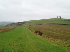
The path soon joined a road near East Hill Farm, and I followed this road southwestwards towards the village of Heytesbury. Before the village was reached the path diverted off to the right across fields, skirting the hillside to the north of the village. The weather was again awful as I passed the tumulus on the summit of Cotley Hill, and started the slight descent towards the impressive ramparts of Scratchbury Hill. This involved walking across newly ploughed fields, and the chalk soil clung heavily to my boots; just what I wanted on a wet day. Eventually I reached the ramparts and followed a sign that pointed downhill along a track. By the time that I got halfway down the track I realised that I had gone the wrong way; stupidly I was trying to keep my map dry by keeping it in my pocket. On the map it was obvious that the path skirted the eastern side of Scratchbury Hill.
I was tempted to go back up the track and rejoin the path, but I really wanted to get the walk over and done with, so I decided to follow the track through North Farm and along the public road back to the Perimeter Path. I joined this at the place where it crossed a public road, and I started the climb back uphill onto Middle Hill. This was followed by a short descent and a climb up onto Battlesbury Hill. I made a slight diversion to visit the trig pillar on the top, passing a reasonably mature and curious Bullock on the way. The path became more indistinct as it headed northwards down off the hill, before reaching a road by the Warminster Training Centre.
The path skirted the high-security section of the camp (with the double chain-linked fences carrying no photography' signs), before following roads through the residential area. By now I was truly fed up with the weather, and I could hardly wait for the walk to end. I headed down the last hill towards Warminster, headed under the railway bridge and joined the main road through the town. Previously Sam had arranged to meet me at the railway station, but she had since phoned me up and told me that she was parked at the town centre car park, and so I decided to head straight there and get dry. I officially ended the walk at the Tourist Information office, and headed back to the car. I could not wait to get my rucksack and coat off, which were absolutely soaking. My arms and back were dry, but the front of my T-shirt was soaked from rain and perspiration. I had enjoyed the walk in a perverse, masochistic way, but I think that I hardly saw Salisbury Plain at its best.
Directions
This walk starts off in the car park of the Royal British Legion in Shrewton, which is near to the church. Leave the car park and turn left, to start heading northwestwards out of the village along the A360 road. Pass the junction with the B390 on the left, and continue on up the hill. Just after a left-hand bend turn left along a green lane (actually a by-way) at The Gibbet. When the by-way turns off to the right fairly soon continue straight on along a green lane. Initially this heads westwards, before taking a slightly more northerly route. The path is easy to follow on the ground even though it is unfenced, and it crosses a couple of concrete tank tracks before eventually reaching the Imber Range Perimeter Path at another concrete track, just before the buildings of the Copehill Down mock German village is reached. From here the Path heads off to the left and is signposted; I found it easier to join the track and follow that around the south side of the village (however, if you do this be very aware of military vehicles).
The path became more distinct on the southwestern side of the village, where a T-junction in the tracks is reached. Here follow the path as it heads westwards across the plain for a couple of miles, before eventually descending downhill to meet a road junction to the east of Chitterne. Head westwards down this road for a short distance to another T-junction, and then turn left to head south for a few yards to a T-junction with the B390 road. At the B390 turn right to walk westwards past the village pub, and at a sharp left-hand bend turn right up another track that heads steeply uphill to the northwest onto the top of Breakheart Hill.
The path from here is distinct and easy to follow; be careful not to divert to the north into the military firing range. Just beyond Knock Castle the path joins a concrete tank track, and this is followed as it heads westwards for a couple of kilometres until a sharp left-hand bend is reached. Here I went wrong and I continued along the track as it curved away to the southwest. Eventually I reached a road near East Hill Farm, and I could see a signpost for the path pointing away to the right, which shows that the path head left the track sometime after the left-hand bend, and I had missed the turning. The difference between following the path is slight, so it is not a major problem.
Once the road at east Hill Farm is reached turn left to follow the road as it heads southwestwards. After a little under a kilometre the road curves to the left to head southwards, and after another couple of hundred yards turn right to follow the path as it leaves the road and heads steeply uphill to the west. The path is easy to follow as it heads westwards towards the summit of Cotley Hill, and it then turns to head northwestwards towards the ramparts of Scratchbury Hill.
The path meets the end of a track and then leaves it to head around the eastern side of the hill (again, I went wrong in the rain and followed the track downhill to the northeast, ending up just to the east of North Farm). Once on the western side of the hill the path descends a few yards down to a road, which it crosses before climbing steeply up onto Middle Hill. Skirt around the western side of Middle Hill, and then follow it as it heads northwestwards, crossing a small dip before climbing up onto Battlesbury Hill. Follow the path around the hill, and once on the northwestern side continue on along the path steeply downhill until it meets the road on Sack Hill.
At the road turn left and follow it as it heads southwestwards past the Warminster Training Centre. Pass the entrance to the centre and then turn right along another road that heads northwestwards, passing an estate of military housing (all, uniformly ugly) before climbing up a slight rise and ending at a T-junction with another road near Parsonage Farm. Here the route finally leaves the Imber Range Perimeter Path; turn left and follow the road as it heads downhill to the southwest. A little under a kilometre later the road passes under a railway bridge and then, a couple of hundred yards later the road ends at a T-junction with the B3414 road in the centre of Warminster. Turn to the right and follow the B3414 road northwestwards for a couple of hundred yards until the Tourist Information office is reached on the right near the road that leads down to the railway station, where this walk ends.
Distances
| From | To | Distance (m) | Ascent (ft) | Descent (ft) |
|---|---|---|---|---|
| Shrewton | Chitterne | 5.6 | 338 | 289 |
| Chitterne | Heytesbury | 4.7 | 377 | 364 |
| Heytesbury | Warminster | 6.4 | 932 | 879 |
This makes a total distance of 16.7 miles, with 1647 feet of ascent and 1532 feet of descent.
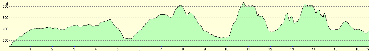
For more information on profiles, ascents and descents, see this page
Disclaimer
Please note that I take no responsibility for anything that may happen when following these directions. If you intend to follow this route, then please use the relevant maps and check the route out before you go out. As always when walking, use common sense and you should be fine.
If you find any information on any of these routes that is inaccurate, or you wish to add anything, then please email me.
All images on this site are © of the author. Any reproduction, retransmissions, or republication of all or part of any document found on this site is expressly prohibited, unless the author has explicitly granted its prior written consent to so reproduce, retransmit, or republish the material. All other rights reserved.
Although this site includes links providing convenient direct access to other Internet sites, I do not endorse, approve, certify or make warranties or representations as to the accuracy of the information on these sites.
And finally, enjoy your walking!
Nearby walks
| # | Title | Walk length (miles) |
|---|---|---|
| 790 | A circular walk from Salisbury | 24.0 |
| 820 | A circular walk from Shrewton | 22.2 |
| 849 | A circular walk from Urchfont to Etchilhampton and West Lavington | 16.4 |
|
|

|