Walk #628: Bakewell, Monsal Dale and Lathkill Dale
 |
 |
|
General Data
| Date Walked | 09/10/2004 |
| County | Derbyshire |
| Start Location | Bakewell |
| End Location | Bakewell |
| Start time | 10.17 |
| End time | 16.51 |
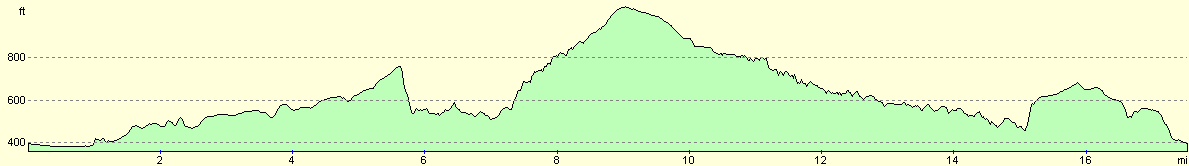
| Distance | 17.7 miles |
| Description | This was a superb walk, taking in a couple of the most beautiful Derbyshire valleys, Monsal Dale and Lathkill Dale. |
| Pack | Today I carried my 30-litre Karrimor HotRock rucksack, which was filled with three litres of water, a fleece, waterproofs and various electronic gadgets. |
| Condition | Considering the fact that I had not done any walking for over a month I was surprisingly okay after this walk; I had no blisters and my feet and legs were fine; indeed, if there had been more daylight I could easily have walked further. |
| Weather | The weather today was a combination of sunshine and cloud, and although at time some grey threatening clouds came overhead it never rained. There was quite a keen breeze that helped kept the temperature down, and it was certainly not a warm day. Autumn is definitely upon us. |
| OS map | Outdoor Leisure number 24 (The Peak District - White Peak Area) |
 |
 |
|
 |
 |
|
Map of the walk
Maps courtesy of Google Maps. Route for indicative purposes only, and may have been plotted after the walk. Please let me have comments on what you think of this new format. For a detailed table of timings for this walk, please see the table file.
 |
 |
|
 |
 |
|
Notes
It had hardly been a trouble-free week, in a far from trouble-free month. A series of upsets in my personal life had meant that I had not done a walk for over a month, and I was not planning to do one this weekend. However a little over a week ago a friend of mine, Vince Kay, died, and so yesterday I found myself driving up the A1 to the crematorium at Brimington, near Chesterfield, with my existing plans for the weekend thrown into upheaval.
Instead of driving back to Cambridge after the wake I drove to my parent's house near Uttoxeter, and thus the next morning I found myself in Derbyshire with nothing to do for the day. I had foreseen this possibility, and so I had packed all my walking gear into the boot of the car before setting off the previous day. The only question was where to walk; I fancied doing a walk that Vince would have liked and recognised, and I therefore chose a circular walk based on Bakewell, taking in some of the most beautiful valleys in the Peak District.
After the funeral yesterday my heart was not really in the walk, and this meant that I set off much later from my parent's house as I had wanted, and this also meant that I arrived at Bakewell just before ten. As I approached from the Rowsley direction along the A6 I saw some car parking signs and these led me to a large car park beside the cattle market, none of which existed when I had spent much time in Bakewell ten years before. I parked my car, slowly and reluctantly put my gear together, and headed over the pedestrian bridge to the Tourist Information office in the centre of the town.
Bakewell is a town that I have always liked, and on this autumn Saturday morning it was not too busy; the only thing that spoils the town being the vast throngs of tourist it attracts on sunny summer weekends. Despite the fact that I had my rucksack on, my GPS had acquired satellites and there was nothing to delay me starting the walk, I procrastinated by visiting the Tourist Information office. I was also tempted to buy a couple of Bakewell Tarts for the walk, but I decided against it, and after I left the T.I. I added to the delay by going into a shop to buy a couple of chocolate bars.
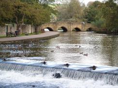
I finally realised that if I was going to finish the walk at any decent time I would have to set off, so I headed back to the T.I. and started the walk, heading across the footbridge over the mill leat and the river, beside which were several people feeding the noisy ducks and swans. I found myself wishing that I could join them, but I knew that I had to walk on. The car park was slightly fuller than when I had parked there half an hour before, and as I passed the fairly ugly cattle market building and some of the more salubrious surrounding buildings, including a farmers market café, which was sadly shut.
My target as to reach the eastern end of the Monsal Trail, a footpath that follows the course of the long-disused Matlock to Buxton railway line. I knew Vince from Peak Rail, an organisation striving to reopen this line, and so incorporating a stretch of the trail seemed like an obvious thing to do. The trail starts a distance out of Bakewell, and the footpath initially followed the access road to the new car park before continuing on when the road turned off to the right to cross the river. The initial stretch of path was not particularly nice, although just before I diverted off it met the River Wye, which was slightly more pleasant.
I soon found myself on Coombs Road, and straight ahead of me was the imposing Coombs Road viaduct; not the largest structure on the line, but in this quiet and secluded place its height seems exaggerated. A good path led up to the top, and I was then on the start of the Monsal Trail. I walked up to the gate that guards the old railway route through Haddon Estate, and I found myself wishing that I could walk on and through Haddon Tunnel, a fairly famous railway structure that has a maximum depth of only eleven feet, and was built by the cut-and-cover method. The only reason for the tunnel being there instead of a cutting is that the Duke of Rutland, who lives at Haddon Hall, did not want steam trains running through what is essentially his back garden. Construction of the tunnel cost five lives when there was a collapse on the 2nd July 1861, and I wonder how the then Duke of Rutland felt about the fact that his privacy required the deaths of five men.
As I walked along the Monsal Trail towards Bakewell I could not help but imagine the line re-opened, with trains carrying passengers and stone passing under the stone bridges. It is a nice thought, but one that is undoubtedly going to take more time to implement. I soon arrived at the site of Bakewell Station, which has elegant buildings that include the Duke of Rutland's coat of arms, as this was his local station (it should be noted that the wall to the right, designed to match the main station building to the left, is actually a false wall and there are no buildings behind it, only an embankment). Bakewell station used to have a canopy that was reputedly designed by Joseph Paxton, which is a possibility as he was a director of the Midland Railway at the time, and had become famous as being the head gardener at Chatsworth House. Unfortunately where the station probably looked fine and imposing when it had canopies and was in use, it now looks slightly misplaced, as the gaps between the platforms have been filled in and the canopies removed, leaving a zigzag pattern on the walls of the buildings.
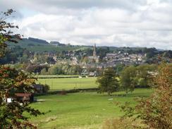
As I walked away from Bakewell Station I overtook a group of people walking along the path, and I was surprised to see that they were all carrying or wearing hard hats. Initially I thought that they must be pot-holers, but they did not seem to have the necessary clothing or gear with them. Once I had passed them, however, I realised that it must have been a party of people who were walking through the tunnels on the line, something the Peak Park organise every so often for limited numbers of people. The trail led on, through cutting replete with colourful bushes and flowers, to reach the site of Hassop Station. As Bakewell Station was the Ducal station for the Duke of Rutland, Hassop Station was the Ducal station for the Duke of Devonshire, at his nearby Chatsworth House.
I was pretty much on autopilot as I walked westwards along the Monsal Trail, passing through the site of the lovely Great Longstone Station (one of the best preserved stations on the line, with platforms still in place and a station building that looks much as it would have in the sixties. Immediately beside, and slightly higher than, the station, is Thornbridge Hall, an imposing building that was ideally located for the station; unfortunately the village of Great Longstone itself was not, as it is a couple of miles away. A short distance on from Great Longstone the trail left the trackbed and diverted across fields to reach the small village of Little Longstone. This diversion is needed to avoid the 533-yard long Monsal Head tunnel (also known as Headstone tunnel), which is closed to pedestrians.
I did not hang around much in Little Longstone, but followed the trail as it headed uphill along a road to reach the Monsal Head Hotel. This was a place where I had spent many pleasant evenings in years past. Instead of going into the main pub I chose to go into the Stables bar, which is housed in a smaller building next to the hotel. There was some cyclists sitting outside the bar, and when I went in the warmth of a glowing fire greeted me. I instantly felt at home, and I ordered a pint and sat down for a quiet drink.
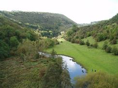
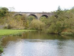
It would have been very tempting to spend the entire afternoon there, but I had only walked about five miles so far, a criminally short distance, and so with some regret I left the bar and walked the few yards to the viewpoint over Monsal Dale. The views from this viewpoint are some of the most famous in the Peak District, and when I stood there it was obvious why; the views are simply superb. Foliage blocked my views of the Monsal Dale viaduct below, but the dale stretched away in front of me. I soon found myself making my way down the steep path that leads onto the top of the viaduct. Immediately to the east of the viaduct the line plunges into Monsal Head tunnel, but the viaduct itself is an impressive structure, and more than compliments the valley.
This was not always thought to be the case, and the famous poet John Ruskin wrote the following about the viaduct and Monsal Dale: "There was a rocky valley between Buxton and Bakewell, once upon a time as devine as the Vale of Temple; you might have seen the Gods there morning and evening - Apollo and all the sweet Muses of the light - walking in fair procession on the lawns of it, and to and fro among the pinnacles of its crags. You cared neither for Gods nor cash (which you did not know the way to get) you thought you could get it by what the Times calls 'Railway Enterprise.' You enterprised a railway through the valley - you blasted its rocks away, heaped thousands of tons of shale into its lovely stream. The valley is gone and the Gods with it, and now every fool in Buxton can be at Bakewell in half an hour and every fool in Bakewell in Buxton; which you think a lucrative process of exchange - you Fools everywhere."
Ruskin wrote this as the line was being built, and I can imagine that the viaduct would have been a great scar on the landscape for the first few years. The passage of well over a century has mellowed the scene, and I cannot believe that Ruskin would have been so harsh today. As I made my way down the steep path from the viaduct to the valley floor I could not help but glance back at the towering arches of the viaduct, and once on the valley floor the viaduct is a superb sight; it seems to almost grow out of the valley and can only ever be described as complementing the local scenery. Oh, if only steam trains could still be passing over it, what a sight it would make!
Once on the valley floor I had left the Monsal Trail, and I started following the path downstream beside the River Wye. The valley is beautiful, and I took my time as I headed south along it. There is a pretty weir that is followed by a footbridge over the river, but after this the path became more cramped in and the views less spectacular. The A6 eventually intruded onto my route, and I dashed across this to get to the lay-by on the other side, which was full of parked cars, the owners obviously all out on walks.
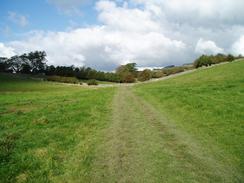
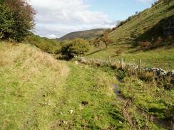
I had chosen to follow Deep Dale southwards, but the path that leads to the Dale actually climbs uphill onto the eastern side of the dale. I had to be very careful to find the path that led down into the dale from the valley side, and it turns out this led through an area of low trees that I had to nearly double over to get through. Deep Dale is quite aptly named as it is indeed deep, and down the bottom a stream was flowing quite fast. This was obviously slightly swollen after recent rain, and as I headed up the valley I soon realised that the path must follow the other side of the fence that runs alongside the stream. I could not be bothered trying to cross it, and chose to continue up on the side that I was on. This involved squeezing past several fences where the stream flew right beside a post, but I did it with no problems and my feet remained dry.
Deep Dale eventually widened and became shallower, and I came across a stile that crossed the fence. I had no reason to cross as I was now on the right side, and I soon joined a track that led on to a minor road. Beside this road there were a bunch of what I assume must be schoolchildren on a Duke of Edinburgh's award trip, along with two teachers, boiling up some tea. The skies overhead was becoming darker, and I hoped that it would not start to rain. Fortunately the clouds soon parted, and I could even see occasional glimpses of sunshine as I crossed fields, heading towards Monyash. When I reached a road I diverted away from Monyash and headed down Bagshaw Dale, a not very inspiring valley that soon ends at the B5055 road.
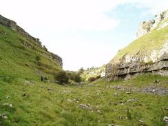
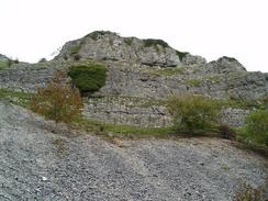
Whilst Bagshaw Dale was uninspiring, what was to follow was perhaps one of the best of all the Derbyshire Dales. Lathkill Dale is rightly famous, although as I headed eastwards from the toilets beside the B5055 the joys were to come were not obvious; the valley starts off quite wide, and it is some time before the valley sides started enclosing around me. The path became rocky in places, especially where it passed an old quarry, and I was surprised to see that the valley did not have any water flowing down it. A little further on I came across the reason - the River Lathkill flows out of a cave in the southern face of the valley, and from this point on the walk became slightly easier as the path was better. There were plenty of people out walking as I headed along the valley, listening to the burbling sound of the water as it passed along the valley.
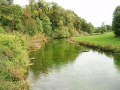
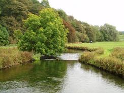
Lathkill Dale was particularly scenic, although in the lower reaches the river develops a slightly different character, sluices having been built to widen the river and form pools for fish. The river therefore becomes slower flowing, which is a shame, as it must have lost some of its character. Eventually I emerged at Conksbury Bridge, which I crossed to gain the footpath on the southern side of the river for the short distance to the footbridge that leads over the river near Raper Lodge. I crossed the river using this attractive bridge, and then headed steeply up the valley side. This was not too steep a climb, and I soon found myself at a farm.
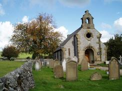
Here I joined a bridleway that headed almost directly northwards for a little under a kilometre until I reached a road. Here there was a trig point that I wanted to visit, but unfortunately there was a tractor and some farmers in the field right by the pillar. They were rounding up some sheep and it was obvious that they would be there for some time, so although I could see the pillar clearly I decided not to visit it, and instead plodded on down the road. Shortly past Noton Barn Farm I left the road and joined a footpath that headed slowly northwards towards Bakewell, descending into a valley and out if it before eventually reaching a road once again. The road passed a couple of small churches, before I diverted off down a steep, stepped footpath.
On the way down the path a squirrel came running down a tree beside the wall and stopped, looking at me. I was only a couple of feet away and so I slowly got my camera out, taking a minute or so to do so in order not to startle it. Unfortunately just as I got the camera to my eye it jumped down off the wall and went down into the undergrowth and I missed what could have been a beautiful photograph. I soon found myself by the A6 in the centre of Bakewell. I could not resist going into a couple of walking shops to have a look for some kit, and then headed past the famous Bakewell pudding shop, where I bought a couple for tea when I got home. Eventually and after much delay I found myself back at the Tourist Information office, after a highly enjoyable walk.
This walk is dedicated to the memory of Vince Kay. You were a great bloke, and you will be truly missed.
 |
 |
|
Directions
This walk starts off at the tourist information office in the centre of Bakewell. Leave the tourist information office through the main door and turn to the left, to enter a small car park. Head diagonally across the car park and then join a road that heads southeastwards past some shops until a footbridge over a mill leat is reached. Cross this bridge, continue straight on across a small car park before reaching a larger footbridge over the River Wye itself. Once on the other side pass to the right of the toilet block and head towards the cattle market building, before turning right to start heading southeastwards along the access road to the cattle market. After a few hundred yards the road curves to the right to cross the Wye on a bridge; here continue straight on along a footpath that heads southeastwards. The footpath skirts the River Wye and then crosses a simple plank footbridge; cross the bridge and once on the other side turn left along a short stretch of footpath that heads eastwards until it hits a small patch of woodland.
The footpath ends at a T-junction with a bridleway by the woodland. Turn left along this bridleway and follow it as it skirts the base of the woodland before passing a sewage farm and ending at a road. Turn right along this road for a couple of yards towards Coombs Road viaduct, and then turn left up some steps that lead up to the start of the Monsal Trail and the viaduct. Once at the top turn left, and start following the Monsal Trail as it heads northwestwards, passing to the north of Bakewell and the sites of the old Bakewell, Hassop and finally Great Longstone Stations. A few hundred yards past Great Longstone station follow the Monsal Trail as it leaves the old railway line to the right, heading northwards across a couple of fields before ending at a road in Little Longstone. At the road turn left and follow it as it heads uphill to the west, passing a little chapel before reaching the B6465 road at Monsal Head. Carefully cross the road, and once on the other side pass the hotel and turn right to the car park.
Cross the small car park and go through a little gap in the low stone wall to reach a footpath on the other side. Turn to the right and follow the footpath as it heads steeply downhill, and after a hundred yards turn left down an even steeper footpath that leads down to the eastern end of Monsal Dale viaduct, near the western portal of Headstone Tunnel. Once on the viaduct turn right and walk westwards across it and then immediately turn to the left to walk down a footpath that leads onto the valley floor, from where some dramatic views of the viaduct are available. Once on the valley floor follow a footpath that heads southwestwards, following the River Wye downstream. The path is easy to follow as the river winds around, passing a weir and a footbridge before settling on a southerly course, with the dramatic hillside of Fin Cop visible to the left. The footpath becomes narrower and passes through alight wooded areas before it eventually ends at the A6 road at Lees Bottom.
Once at the A6 cross it, cross the adjacent lay-by and follow a footpath that heads south with a slope to the right. After a few hundred yards a footpath leads off to the right, signposted for Deep Dale; follow this footpath as it climbs westwards up a valley. Near the top of the valley follow a footpath that heads off to the left, initially going through a clump of low trees, before dropping down into Deep Dale itself. Once in the Dale the footpath runs on the other (eastern) side of the stream; I continued on the western side and both seem reasonably good. As the southern end of the dale is reached it starts to widen out and the sides become less precipitous, before the path eventually crosses over to the western side of the stream and, soon afterwards, a green lane is reached. Head straight on uphill southwards along the green lane until a road is reached. Cross the road, and once on the other side continue straight on along an obvious footpath that head southwestwards for a little under a kilometre before turning to head southwards and ending at Horse Lane, immediately to the north of Monyash.
Cross Horse Lane and once on the other side follow a footpath that heads southeastwards for a little under a kilometre until it ends at the B5055 road. Cross the B5055, pass the public conveniences and continue southeastwards along a footpath. Initially the valley is quite broad, but the further on you go the deeper it becomes; when a path heads obviously uphill to the right continue down through the valley straight on. The sides of the valley become precipitous in places and the disused Ricklow Quarry is passed, before eventually the River Lathkill emerges out of a cave to the right. Continue following the river as it meanders in a rough easterly direction, staying on the north bank for a few miles until eventually Conksbury Bridge is reached. Cross the bridge and once on the southern side of the river continue on uphill along the road for a few yards before taking a footpath that leads off to the left. This footpath skirts the side of the valley southwards for about half a kilometre until a track is reached near Raper Lodge.
At the track turn left and follow it down to a pretty little bridge over the river. Cross the bridge, and once on the other side head uphill along a steep footpath that emerges out of some woodland in a field. Head slightly north of eastwards across this field until a farm is reached, and then turn left to walk northwards along a bridleway that follows a field boundary for about a kilometre until a road is reached. Head straight on northwards along the road past a road junction to the left, and when the road curves to the left turn right along a footpath. This footpath heads north across fields and descends down into a small valley; it then climbs up out of the valley to the northeast and then settles on a northerly course until it reaches the end of a road beside a school. Head northwards along this road past two small churches to the right, and once a larger road is reached turn right down a little pedestrianised lane that heads downhill to the north. The lane emerges out onto a larger road; turn right down this road to the main roundabout with the A6. Cross the roundabout and continue straight on to the northeast; the tourist information office on Bakewell where this walk ends is a hundred yards away on the right.
Distances
| From | To | Distance (m) | Ascent (ft) | Descent (ft) |
|---|---|---|---|---|
| Bakewell | Monsal Head | 5.8 | 741 | 390 |
| Monsal Head | Monyash | 4.4 | 741 | 640 |
| Monyash | Bakewell | 7.5 | 942 | 1394 |
This makes a total distance of 17.7 miles, with 2424 feet of ascent and 2424 feet of descent.
For more information on profiles, ascents and descents, see this page
Disclaimer
Please note that I take no responsibility for anything that may happen when following these directions. If you intend to follow this route, then please use the relevant maps and check the route out before you go out. As always when walking, use common sense and you should be fine.
If you find any information on any of these routes that is inaccurate, or you wish to add anything, then please email me.
All images on this site are © of the author. Any reproduction, retransmissions, or republication of all or part of any document found on this site is expressly prohibited, unless the author has explicitly granted its prior written consent to so reproduce, retransmit, or republish the material. All other rights reserved.
Although this site includes links providing convenient direct access to other Internet sites, I do not endorse, approve, certify or make warranties or representations as to the accuracy of the information on these sites.
And finally, enjoy your walking!
Nearby walks
| # | Title | Walk length (miles) |
|---|---|---|
| 11 | Stanton Moor | 2.9 |
| 12 | Darley Dale, Stanton Moor and Rowsley | 8.7 |
| 14 | Friden, Long Dale and Gratton Dale | 7.8 |
|
|

|