Walk #627: Horton in Ribblesdale to Kingsdale via Ingleborough and Whernside
 |
 |
|
General Data
| Date Walked | 04/09/2004 |
| County | North Yorkshire, Cumbria |
| Start Location | Horton-in-Ribblesdale |
| End Location | Kingsdale |
| Start time | 08.50 |
| End time | 16.30 |
| Distance | 14.1 miles |
| Description | This was a strenuous but rewarding walk, taking in two of the three highest peaks in Yorkshire on the way. The route finding was fairly straightforward, and if the weather had been better the views would have been fantastic. |
| Pack | Today I carried my 30-litre Karrimor HotRock rucksack, which was filled with three litres of water, a fleece and various electronic gadgets. I did not carry my waterproofs as I had to wear them due to the weather. |
| Condition | I feel absolutely fine after this walk, and I could easily have walked on further if I had needed to. The underside of my left foot aches yet again, although this was not too bad as I did not spend a great deal of time walking on roads. |
| Weather | The weather forecast for today was for sunshine, yet in this part of the country this singularly failed to be the case. The day dawned with the mountaintops covered in a veil of clouds, and this remained the case throughout the day. On the tops the wind was quite keen and on the descent from Ingleborough it started to rain, although this soon stopped. In the cloud it was quite cool (especially when exposed to the wind), and below the cloud it was reasonably warm. All in all the weather could have been much better, particularly as the low cloud spoiled all views from the tops. |
| OS map | Outdoor Leisure number 2 (Yorkshire Dales - Southern & Western Areas) |
 |
 |
|
 |
 |
|
Map of the walk
Maps courtesy of Google Maps. Route for indicative purposes only, and may have been plotted after the walk. Please let me have comments on what you think of this new format. For a detailed table of timings for this walk, please see the table file.
Notes
One of the significant problems with living in Cambridge is that it is generally one heck of a drive to get to hilly areas, and therefore many of my walks are based in the (relatively) flat areas within a couple of hours drive of home. True, there are some lovely hilly walks to be done; the South Downs and North Downs are just about reachable for day walks, but for true hill walks I have to drive three hours into the Peak District. Snowdonia and the Pennines are four hours away, the Lake District five, and thus are not visited very often. This means that whilst I visit some beautiful places in the lowlands, I have to leave hill walking for longer trips.
However sometimes unexpected opportunities come by. Sam and I have a good friend Jacqui, who is an outdoors type of girl, and we had arranged to go away camping for the weekend. I immediately saw an opportunity to get somewhere that I do not normally get to very often, and after a little thought we decided that it would be nice to get up to Horton-in-Ribblesdale, in North Yorkshire. This would give me the opportunity to walk up to the summit of Whernside, the highest point in North Yorkshire, and thus tick off another county top summit. It was tempting to do the entire Three Peaks, but I soon decided against it for several reasons. Firstly, Jacqui was walking with me, and I wanted time to be able to chat to her. Secondly, although I have done Pen-y-ghent before on my Pennine Way walk, I have never done Ingleborough and Whernside, and I wanted to take my time and get to know these mountains somewhat.
We arrived at the campsite a little before nine, and whilst we were putting up our tent in the last vestiges of daylight Jacqui turned up after her journey from Bromsgrove. We had a good laugh as Jacqui has trouble putting up a tent she has put up many times before, and then retired to the pub. This was absolutely heaving, and instead of spending time in the hot and smoky bar we went to sit outside. It quickly got cooler, but we were amazed when two friends from the scuba diving club that the three of us attend in Newmarket turned up unexpectedly, and we ended up chatting late into the evening. After looking at the map Jacqui and I decided to do Ingleborough and then Whernside, which would give us a nice walk that we could take our time over.
Another advantage of doing a relatively short walk was that in the morning we could go to the Pen-y-ghent cafe just up the road from the campsite for a superb bacon and egg sandwich. The cafe is the start and end point of the Three Peaks walk, and as we ate and chatted many walkers came in to log the start of their gruelling day's walk. Jacqui and I were less concerned, however, and I took some sort of perverse joy in the tense anticipation many of the participants were in. Eventually it came time to leave, and so we said goodbye to Sam, left the cafe and started off down the road. Horton in Ribblesdale is a pretty little village, and the River Ribble was a nice sight, with an attractive wooden bridge leading over it beside the road bridge. The next hundred yards down to the railway station was notable as a couple of stone lorries came close by past us, but we safely managed to reach the station.
The station was well cared for and very pretty; it on the Settle to Carlisle railway line, which successfully fought a long campaign against closure in the 1980's. The line is now nearly as busy as ever, and it regularly takes diversions off the West Coast main line as the latter's near never-ending upgrade scheme continues. The initial footpath section of the Three Peaks then followed, along a path that was wide and ludicrously easy to follow as it was well trodden by thousands of pairs of feet before ours. The initial stretch was relatively flat, and we walked side by side as we strolled along; it was so nice to be able to chat with Jacqui about how our lives had been progressing in the couple of months since we had last seen each other.
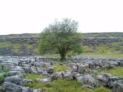
When we approached the little escarpment called Sulber Nick we decided to take a little excursion northwards to visit the trig point that lies about half a mile to the north. There was a relatively easy to follow track beside the edge, and when we reached a beautifully-situated tree on a small detached section of limestone pavement we climbed up to reach the trig pillar. I did my usual task of photographing and logging it, and we then set off back to the Three Peaks path. This led us across a trackless expanse of limestone pavement on which the combination of clints and grykes were beautiful but also potentially ankle-twisting good. We took this stretch slowly and I looked around, enjoying the scenery, although I did not like the look of the cloud that hung a few hundred feet above our heads, obscuring any views of the tops of the hills. The weather forecast was for good weather, so the low cloud was more than a bitter disappointment.
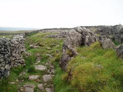
We rejoined the Three Peaks path only a short distance from where we had left it, near to a double ladder stile leading over a wall. More talking occurred as we followed Sulber Nick westwards, passing more fantastic limestone scenery before we eventually reach the start of the climb up Simon Breast Fell. This was far from the steepest climb that I have ever done and we made our way quite speedily up it, the only thing of note being the fact that we finally entered the layer of cloud. In a couple of places we were exposed to a strong wind that proved quite chilling, but we soon managed to get out of this (presumably by going behind the lee of the hill), and passed a little lake (unusual on limestone terrain) before reaching a junction in the paths near the summit.
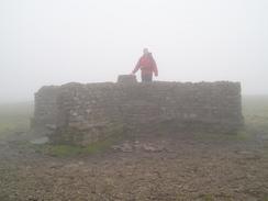
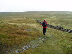
Some rough stone steps lead upwards through the clouds and beside a large rock protrusion before reaching the summit plateau. As soon as we finished the climb we were exposed to the full force of the wind, which blew the cloud towards us as we walked across to the shelter and trig point at the summit. Visibility was fairly awful at the summit, and I took some photos of Jacqui as she stood on top of the shelter before making my way to the trig pillar. The wind was if anything fiercer, so after taking some obligatory summit photos we retired to the shelter, where we were not quite as exposed to the wind. It was still slightly chilly, so after sitting down for a couple of minutes we made the decision to leave and make our way down out of the cloud layer. The initial part of the descent down to the footpath junction was easy, and it was here that we met a group of men who were having a rest. We started on down the steep stone steps that lead down northwards towards Humphrey Bottom; these were steep and very slippy, so we took our time on the descent.
At the bottom we had a short breather and I realised with some shock that my legs felt rubbery; I should not have had a problem with that descent but I did, and I took this to be a sign that I am not as fit for hill-walking as I should be. My legs soon recovered as we walked across the long flagstone path across Humphrey Bottom, and on the way we passed a one-legged man walking uphill in the other direction. This filled me with amazement and wonder at his courage; I can only hope that if I ever had such adversity thrust upon me that I would be as brave. When the flagstones ended a nice walk across enclosed fields took me past the large sinkhole called Braithwaite Wife Hole, which is well known to cavers in the area. Looking down the hole was quite impressive, although I do not think that I would like to go and explore inside the hole - caving is not for me!
Soon after this we reached the road and walked down it for a few yards to the Old Hill Inn, and we gratefully went inside, hesitating for a minute about whether or not we should take our boots off. I ordered a pint of Black Sheep's finest ale and Jacqui had a soft drink, and as we supped we started chatting to the group of men sitting at the next table, whom we had passed on the descent off Ingleborough. It turns out that they were a walking group from Burton-on-Trent called 'Fukarewe', or something similar (short for where the f**k are we?), who were out on a trip celebrating the 25th anniversary of the club. It turned out that one of the men at the able was the headmaster of Thomas Alleynes, the school nearest to my parent's in Uttoxeter, and a great rival of the school that I attended.
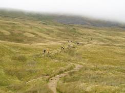
The food at the pub smelt lovely, and it was very tempting to order a meal, especially as I was hesitant about continuing on, as my heart was not on the walk. As we headed up Philpin Lane we passed a farm, where there were some stands set out, and then the first energetic bunch of Three Peakers. Amongst these we recognised a couple of people who had been in the Pen-y-ghent cafe this morning, and more and more people passed me as we headed along the road. When the road ended at Bruntscar we could see a long line of people heading down the zigzag path from Whernside, and as we started the ascent we occasionally had to go off the path to let groups of them by. About halfway up the climb the flow became a torrent, but by the time we had ascended up into the cloud layer there were only drips and drabs heading down the hill, all looking very tired.
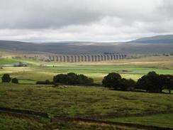
We both found the walk up the hill to be fairly easy, although we were bitterly disappointed that there were no views to be had; we had seen some classic views of the Ribblehead viaduct before we had entered the cloud layer, but afterwards there had been nothing but cloud. Once the gradient had slackened we found ourselves on a seemingly endless path northwards, following a wall until eventually a little shelter set into the wall was met, along with the trig pillar on the other side. The wind was quite bitter and so we explored the area for a while, including finding a grotesque mask set into the wall a little way from the shelter, and then huddled down out of the wind. Some chocolate helped keep our spirits up, although I was quite glad that I had reached North Yorkshire's highest point. If only the weather had not let us down!
I found that I had no mobile reception, but Jacqui is with another service provider and she had full reception. Jacqui therefore phoned Sam up, and we arranged to meet her on the Thornton-in-Lonsdale to Dent Road in half an hour. This meant that we could not pause got too much longer (which was a good thing, given the wind chill), and so we headed off down westwards off Whernside. The path was far less well walked then the ones that we had been on, but was easy to follow nonetheless, even tough it went over some fairly boggy ground. We soon emerged from the cloud layer, and we continued chatting all the way down; as we neared the road at its summit we got some lovely views down into the valley towards Dent, with the greens of the valley contrasting nicely with the duller hues of the moorland.
After crossing Long Gill virtually it its head we hit the road, which was single lane and unfenced. There was no sign of Sam, so as we knew that she was coming from the south we started heading down the road. We both felt in fine fettle and agreed that we could easily have walked further, but the nice, uncomplicated and unhurried walk had allowed us to have a really good chat, which was exactly what we both needed. A little over a mile after we hit he road we reached Kingsdale Head, and as we approached the gate across the road at the farm we sae Sam coming towards us. It had been a superb day's walk, and one that I shall remember for a long time to come.
Directions
The majority of this walk follows the route of the Three Peaks challenge walk, although I am doing it in the reverse direction to which it is normally done. The walk starts off at the Pen-y-Ghent cafe in Horton-in-Ribblesdale, where there is a clocking-in station for people doing the walk. Leave the cafe and turn left, to head northwards along the road. This passes a car park on the left before reaching a narrow bridge over a stream; cross this bridge and once on the other side follow the road as it curves to the left near a pub to had westwards. When the road reaches the railway station it curves to the right, but instead of following the road continue straight on along a little lane to the station.
Once the lane ends at the railway station go through a gate to gain access to the end of the platform. With care cross the line onto the other platform, and once there turn slightly to the left to the end of the wall before climbing up a few steps and going through a gate to gain access to a field. The path across the field is well worn and very easy to follow as it heads in a rough northwesterly direction, crossing the access road to Beecroft Hall before starting to climb up a relatively gentle slope. The path now enters some classic limestone scenery with some sections of limestone pavement available. When the slight escarpment of Sulber Edge is reached we made a slight diversion off to the right, heading northwards along the foot of the edge. Our aim was to reach the trig pillar on the edge; after about half a mile (near a solitary tree sitting on an isolated section of pavement) turn to the left and climb up onto the edge to gain access to the pillar. Once at the pillar turn left, and start walking southwards along a superb area of limestone pavement, following a wall on the right, until it descends into a little dip where it meets the route of the Three Peaks walk by a double ladder stile.
Turn right and cross one of the stiles before continuing on up Sulber Nick. The path is easy to follow; just continue straight on as the path heads just north of westwards to Sulber and onwards, crossing the Clapham to Selside path before reaching the lower slopes of Simon Fell. The path crosses a stile and passes Nick Pot (which we missed as it was on the other side of the wall) before heading on uphill. An old, ruined shooters hut is passed before the path reaches Simon Fell Breast. The path is still easy to follow as it heads uphill, and a final steep section leads up past a little tarn on the right before a stony path is reached at a junction in the paths. As we need to visit the top of Ingleborough turn left, and start climbing steeply uphill along a stepped path. Just before the summit plateau is reached the path passes a nicely shaped outcrop of rock, and immediately on the summit is a stone cairn. As the visibility was low we followed the northern edge of the plateau for a few hundred yards, before turning to the left to head southwards to the summit shelter and trig point.
Once the pillar has been reached head back to the cairn and then descend down the steps once more to the junction in the paths. Instead of turning to the right and heading down to Sulber and Horton-in-Ribblesdale, continue straight on along a stone path that leads northeastwards down Swine Tail. After a few hundred yards a path leads off down steps to the left; take this path as it heads very steeply downhill; the path is rough and steep with several zigzags, and care needs to be taken. The steep path eventually ends at an area of boggy ground called Humphrey Bottom, and some flagstones lead onwards slightly west of north for about a kilometre until a wall is reached. The path crosses the wall, and on the enclosed land on the other side continue on; the path is easy to follow as it enters some more classic limestone scenery. It passes the spectacular Braithwaite Wife Hole before reaching Southerscale Scar, where it turns to head northeastwards along the line of the scar. Continue on in this direction, following the path for another kilometre until it reaches the Low Sleights Road at Philpin Sleights.
Once at the road turn left and follow it southwestwards downhill for a couple of hundred yards, passing the Old Hill Inn on the left before reaching a junction with Philpin Lane on the right. Turn right and follow the lane as it heads past Philpin Farm and curves to head northwards before ending before a farm at Bruntscar. When the lane ends turn slightly to the left to follow a path past for a couple of hundred yards past the farm. At a T-junction turn right along another footpath for a few yards, before turning left along another footpath that heads northwards, slowly climbing as it heads across some enclosed land. As the gradient slowly steepens the path starts to zigzag slightly as it heads uphill; the going is not too steep, however, and soon the top of the ridge is reached. Once on the ridge turn right and start following a wall on the left as it heads slightly east of north for a little over a kilometre, slowly rising before reaching a shelter built into the wall. This shelter marks the summit of Whernside, the highest point in North Yorkshire, and on the other side of the wall is the trig pillar.
Beside the shelter is a narrow squeeze stile that allows you to gain access to the western side of the wall and the pillar. Go through this stile to the pillar, and once there head directly downhill to the west. This path is not on the Three Peaks route and is therefore far less clear than the other paths today, but it as easy enough to follow as it headed straight downhill. After about half a mile a steep drop is reached; here the path turns to the right for a couple of hundred yards along the top of the drop until a wall is reached, and then turns to the left to continue the drop downhill for another kilometre. The gradient eventually slackens as the path passes some sinkholes, and eventually the end of Long Gill is reached; cross the stream and then climb up the few yards to the road. Once on the road turn left, and start following it as it winds downhill to the south. The walk ends about a mile and a half further on, by the farm at Kingsdale Head.
Distances
| From | To | Distance (m) | Ascent (ft) | Descent (ft) |
|---|---|---|---|---|
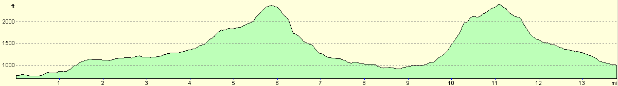
| Horton-in-Ribblesdale cafe | Ingleborough summit | 5.9 | 1788 | 177 |
| Ingleborough summit | Whernside summit | 5.4 | 1568 | 1549 |
| Whernside summit | Kingsdale Head | 2.8 | 43 | 1440 |
This makes a total distance of 14.1 miles, with 3399 feet of ascent and 3166 feet of descent.
For more information on profiles, ascents and descents, see this page
Transport
There is no public transport from the end of this walk; to get back to Horton-in-Ribblesdale you would need to continue on south along the road for another few miles to reach Thornton-in-Lonsdale or Ingleton; from where there may be infrequent services to Horton-in-Ribblesdale. In reality, this is not feasible and this walk is one to be done with someone driving a support car.
Disclaimer
Please note that I take no responsibility for anything that may happen when following these directions. If you intend to follow this route, then please use the relevant maps and check the route out before you go out. As always when walking, use common sense and you should be fine.
If you find any information on any of these routes that is inaccurate, or you wish to add anything, then please email me.
All images on this site are © of the author. Any reproduction, retransmissions, or republication of all or part of any document found on this site is expressly prohibited, unless the author has explicitly granted its prior written consent to so reproduce, retransmit, or republish the material. All other rights reserved.
Although this site includes links providing convenient direct access to other Internet sites, I do not endorse, approve, certify or make warranties or representations as to the accuracy of the information on these sites.
And finally, enjoy your walking!
Nearby walks
| # | Title | Walk length (miles) |
|---|---|---|
| 36 | Malham to Horton in Ribbesdale | 14.7 |
| 37 | Horton in Ribbesdale to Hawes | 14.0 |
|
|

|