Walk #718: A circular walk from Long Melford to Lavenham and Sudbury
 |
 |
|
General Data
| Date Walked | 19/03/2006 |
| County | Suffolk, Essex |
| Start Location | Long Melford |
| End Location | Long Melford |
| Start time | 10.04 |
| End time | 17.17 |
| Distance | 20.5 miles |
| Description | This was a pleasant circular walk in the southwest of Suffolk, taking in part of the old Sudbury to Bury St Edmunds railway line. |
| Pack | Today I carried my 30-litre Karrimor rucksack filled with my waterproofs, two litres of water, a book and various other odds and ends. |
| Condition | I am fairly tired after this walk, but this is not to severe. My knees gave me little trouble, which I am quite glad about. |
| Weather | The day was mainly cloudy, and although it was cold for the time of year there was not much wind so I did not get too chilled, except for when I was on the old airfield at Acton. The clouds parted towards the end of the day and the sun started shining for prolonged periods. |
| OS map | Landranger number 155 (Bury St Edmunds, Sudbury & Stowmarket) |
 |
 |
|
 |
 |
|
Map of the walk
Maps courtesy of Google Maps. Route for indicative purposes only, and may have been plotted after the walk. Please let me have comments on what you think of this new format. For a detailed table of timings for this walk, please see the table file.
 |
Notes
After watching the Malaysian grand prix this morning, I really did not want to drive too far to do a walk. Yesterday I went to the Outdoors Show 2006 at the NEC, and although the show had been very interesting, the cold winds outside had been decidedly chilly during the long walk from the conference halls to the car park. For this reason I was glad to see that the wind had died down, and that the weather looked much more promising than it had yesterday.
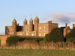
A few weeks ago I had printed out a map of a relatively local walk, and as this was conveniently lying on my computer desk I decided to do this walk. Due to watching a fairly engrossing grand prix it was late before I was ready to head off, and therefore it was also late by the time I pulled up in a small car park in the village of Long Melford, just inside the Suffolk border from Essex. The car park was directly opposite the large and imposing brick façade of the Elizabethan Melford Hall, the red bricks seeming to shine when the sun peeked out from behind the clouds. Unfortunately a large wall prevented me from getting a whole view of the house, but the area that I could see above the first floor level was impressive.
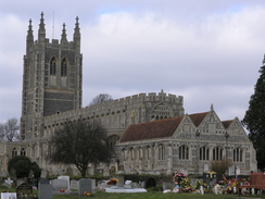
It did not take me long to get my kit together, and as I set off up the path that paralleled the main road through the village I said goodbye to a couple of other walkers who were preparing for a walk. The path headed up towards the A1092 and the church, and as I skirted the side of the churchyard I recalled how I had got stuck in the churchyard during a previous walk. Once at the main road I was surprised to find a set of public toilets hidden in the trees - these were not marked from the road, but were clean and tidy inside. The bells were ringing in the church, and as the peels rang out from the spectacular church I headed off along the road.
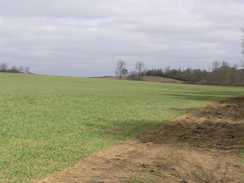
I did not stay on the road for long, although I found it difficult to locate the path that headed off eastwards towards the A134. After a couple of minutes I found it a little farther north than I had expected, and once on it the path was easy to follow, joining a track for a while before reaching the A134. Once across this road the path followed a series of field boundaries along the St Edmund Way, heading towards a transmission mast before curving away and eventually reaching a dark area of woodland. The path through this had been churned up, but the weather recently had been fairly dry and the ground was not too muddy, and after exiting the woodland the path climbed uphill to reach what was marked on the map as an old railway trackbed.
Unfortunately on the ground there was no sign of the trackbed as the field gently rose and fell as it headed northeastwards, but convinced that I was on the correct path I headed on. To my right was a field boundary that had fence posts that looked wrong for normal field fence posts, and looked as though they may have been marking a railway boundary. With the undulating landscape there was no way that a railway could have been built, but after a couple of hundred yards, at the end of the field, there was a bank and, on top of this, I came across the railway embankment. It was obvious that the embankment to the southwest had been removed, leaving only the old fence at the bottom in place, although I was surprised to see exactly how well they had removed all traces of what must have been a fairly substantial embankment.
Once on the embankment the path had a different character, with overhanging trees leading to a gloomier and somewhat darker environment. There was little wildlife to be seen around, and the only real colour was the small white patches of snowdrops that were scattered around. Eventually the embankment emerged into another field where the embankment had been removed, and as I started to cross this a small dog ran up and started to yap around my heels. It was acting quite aggressively, although it was so small I was more likely to suffer from tripping over the little blighter than from it biting me!
The path crossed the field before plunging into a cutting, the first part of which had been filled in. Again it was dark with trees overhanging from high above on the cutting sides, although this situation improved when the path reached a stretch of path where the trees had been cut down, leaving a much more airy, open and enjoyable stroll. As the path headed on there started to be signs of habitation, although it still came as a surprise when an overbridge was reached with a building directly on the other side. This marked the entry into the village of Lavenham, and the path did not pass under the bridge but skirted to the right to dump me unceremoniously on the road at the bottom of the bridge.
It felt strange to be in habitation, and I walked past the factory building that now inhabits the site of the station, the adjacent overbridge being an incongruous sight. A road led me on southwards through the village, past some characterfull buildings with scarcely a single right angle in them. A bridge led across a stream, and after going uphill along a path I realised that I had gone wrong, and, annoyed, I headed back down the path to rejoin a track that led up to Clayhill Farm. At the farm the track became a bridleway, and although it was an easy walk I found it to be fairly flat and boring, and it was a relief when, after a couple of kilometres, the path reached a road.
The road led me south into Brent Eleigh, where I avoided going to the church (which had signs stating its undoubted pleasures) and headed on, passing a village sign on a small triangle of grass near a pretty house, to reach the A141 road. On the other side of the road was The Cock pub, and as I had plenty of time now that the days were getting longer I decided to nip in for a quick drink. As soon as I entered I realised that I was in for a treat, as the décor and ambience of the small bar was enticing, with books on a shelf on the wall and pork scratchings in a bowl on the bar. It felt very much like someone's living room, and after delightfully ordering a pint of Abbot I sat down at the table with two ladies and a man, who were sitting on the other side.
A long conversation ensued as we chatted away, covering various topics including the local area and Cambridge, which they knew. Another pint of Abbot slipped down whilst we talked, and eventually I reluctantly decided that I could not hesitate any longer, and had to get ready to go. After bidding them goodbye I put my rucksack and headed off into the cold air outside. The next mile was along a road that led towards a farm at Abbot's Hall, and I was glad that the road was quiet as the two pints had gone to my head somewhat. At the farm the road ended, but a path led on for a short distance before ending at another road, which led me westwards along a winding road to the B1071.
I could have chosen to follow the B1071 towards Sudbury, but the road seemed to be fairly busy and so I chose instead to take a slightly less direct route that headed straight on from the crossroads. The road was very quiet, and over the next mile I did not see a single vehicle until I neared the little village of Acton. Before I reached the village I took a short section of footpath, which was a relief on my feet after the hard tarmac of the road, which passes some allotments before entering a field and reaching a road in the village. This led on to another footpath, which took me down to an airfield to the south of the village.
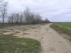
I soon found myself on an overgrown strip of concrete that seemed to narrow to be a runway, despite the strip being nearly a mile long on the map. A little investigation showed that the strip was much wider than first glances showed, and I headed on down the concrete, imagining what it would have been like when it was in use as an airfield. I wondered what sort of aircraft used the airfield, and whether it was a full time airfield or a diversion one. Certainly the lack of structures made me lean in the direction of the latter. When I got home I found out that it was actually quite a large base, and included the main USAAF hospital in the area - see a PDF file for details. The runway was the Sudbury (Chilton) Station 174, home of the 486th Bomb Group (H), and B24 Liberators and B17 Fortress planes flew from it. In total thirty planes flying form the airfield were lost during the war.
I did not know any of this as I walked down the runway, which got wider for a while before becoming narrow to is south-western end, where most of the width had been returned to agriculture. It was little more than a concrete footpath, and this seemed a shame as it was hard to get an impression of what the airfield would have been like. Once I finally reaches the end of the main runway I started following the boundary track around the airfield for a while, and here I got chilled as the wind was coming from the side, allowed a free flow towards me by the lack of buildings on the flat airfield site. It was a relief when I soon reached a footpath that led off to the right, heading down to the B1115 road. Here I turned to head towards the centre of Sudbury, and as I walked along the pavement I started to see large amounts of litter in the hedgerow to my right, most of which comprised of McDonalds wrappers and cartons. It was therefore no surprise when I reached a McDonalds near the A134 roundabout, which must have been the cause of the litter.
A walk of a mile took me down into the centre of Sudbury, and there was nothing of any note as I walked through the outskirts of the town. The centre of the town was more or less the same, with the only thing of note being a large church that was surrounded by roads near the main shopping area. There were few families walking about, but I did not get a very warm and welcoming feeling from the town, which was a stark contrast to the last time that I had been in the town; the fact that it was a Sunday afternoon may have had something to do with it. The fact that the alcohol was finally making its way out of system probably also depressed my mood slightly. I made my way the short distance from the church towards the railway station, where there was a train just setting off for the journey along the branch line towards Marks Tey.
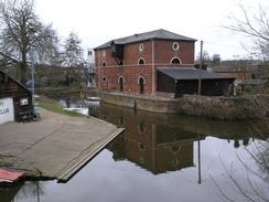
After this things improved, as I walked past a leisure centre and made my way to the start of a footpath that runs along the old Sudbury to Long Melford railway line. Instantly the character of the walks changed, as I left tarmac and was walking along the good surface of the path. The path crossed several little bridges as it looped around the south of Sudbury, and from these there were some nice views over the town, particularly from the bridge where the old line crossed the River Stour. Walking ahead of me there was a lady with some kids and a man, making good speed (indeed, the same speed as me as I never caught up with her) on crutches. As I neared I saw that she had no right leg, and I was very impressed by the rapid speed that she was managing to keep up.
The walk along the railway line was enjoyable as it alternated between running on an embankment and in cuttings as it crossed the border into Essex. When I reached the end of the path at a road near Rodbridge Corner a woman with a foreign accent and broken English stopped me, to ask me where a place was. I could not see the place on the map, but eventually she asked me for Ballingdon, and she looked dismayed when I pointed her back they way that she obviously come. I can only hope that she made it to where she was going before it got dark, as she must have had a couple of miles to walk.
A little stretch of road walking led to a path that diverted me away from Liston Church across a field to reach a road by a small bridge over a stream. This led me to a pleasant stretch of narrow road with the river running to the left and green fields to my right; after a hundred yards this ended when the river turned to head under the bridge. The road continued on into Long Melford, and when I reached the main road I joined this to head on back towards the car park. This was a pleasant enough walk, with some pleasing architecture to be seen on some of the buildings, but by this stage I was tired and I did not really take it all in. It was a relief when Melford Hall became visible again, glowing once more in the afternoon sunlight, and son after I got my first sight of it I reached my car, and I could sit down and think back on what had been a surprisingly pleasant stroll.
Directions
This walk starts off at a car park situated to the west of the B1064 in Long Melford opposite Melford Hall, immediately to the north of the village. Lave the car park and turn left, heading up a track for a few hundred yards that veers away from the B1064 until it ends at the A1092 just before the church is reached. Turn right, and follow the B1062 as it heads slightly east of north through the village, but before the road ends at the A134 road a footpath leads off to the right (following St Edmunds Way), heading southeastwards, joining a track before reaching the A134. Carefully cross this road, and on the other side turn left to walk in a more northerly direction with a hedge on the left. After a few hundred yards the path turns to the right. It slowly curves around to the left, taking a more easterly course before reaching an area of woodland.
Turn left for a few yards before and follow the path before it turns right, to plunge eastwards through the narrow band of trees. On the other side the footpath climbs a slight hill, and when a hedge is reached turn left and start following the course of an old railway line northeastwards. After a while this climbs up onto an embankment, and heads through part of Lineage Wood. Once it leaves the wood part of the course of the railway is obliterated, but this section soon ends and the path enters a cutting that heads on for about two kilometres towards Lavenham.
Once in the village do not try to get under the railway bridge, and instead once it is reached turn right along a narrow path that squeezes past some gardens for a few yards before reaching the A1141 road in the village. Turn left and follow the road as it heads towards the bridge, and after fifty yards turn right sown Preston Road. The road heads past a factory on the left (on the site of Lavenham Station), and then when a crossroads is reached turn right down Lower Road. Follow this road as it heads southwards through the village, and once the road curves to the right after about half a mile turn left along Clay Lane. This crosses a stream on a bridge and then starts heading uphill; ignore the footpath that heads along the field to the left and continue up until the surfaced road ends at Clayhill Farm.
Pass the farm and continue on along the bridleway as it heads eastwards for a couple of kilometres, passing immediately to the south of Spragg's Wood before ending at a road. Turn right and start to follow this road as it winds southwards for a mile, passing near to Brent Eleigh church before entering the village itself. At a junction ignore the road to the left and head straight on, passing to the left of the village sign to reach the A1141 road. Cross the A1141, and on the other side pass to the left of the pub and follow a road that heads southwestwards, curving to head in a more westerly direction before ending after about a mile at Abbot's Hall.
Once the road ends follow a by-way that heads on immediately to the south of the building southwestwards to reach another road. At this road turn right, and follow it as it winds westwards for about half a mile until it reaches the B1071 road. Cross the B1071, and follow another road westwards for about a kilometre to School Farm, where it turns slightly to the left to head southwestwards towards Acton. Shortly after a farm at Barrow Hill a footpath leads off to the left; turn left and follow this footpath as it heads south past some allotments to end at a road in Acton. Turn left and follow this road southwards for a couple of hundred yards to another junction; here turn left for a few yards until another footpath leads off to the right.
This footpath heads southwestward across a small field, before curving to the south for about fifty yards and ending at a concrete road, part of the old runway of an airfield Turn right, and follow the footpath as it runs southwestwards for two kilometres. At it does so the concrete strip becomes narrower, until eventually it is just a narrow path running through the fields on either side. Once the runway ends turn left and follow the perimeter road (which is much wider) as it curves to the left and then the right. On the apex of this latter curve turn right, to head south along a track that heads southwards past a farm at Chilton Grove to reach the B1115. Turn right along the B1115 and follow it as it heads southwestwards for a little under a kilometre until it reaches a roundabout with the A134 on the outskirts of Sudbury.
Cross the roundabout, and continue on along the B1115 road southwestwards for another kilometre towards the centre of the town. When this reaches a church turn left, keeping the church to the right, and after crossing the B1508 head south down Great Easter Road to Sudbury station. Once at the station, head around the large leisure centre building to the entrance of the swimming pool, and walk across the car park to reach a footpath that runs along an old railway line. Turn right, and start following the railway line for about three miles, as it skirts around the south and then the west of the town. The footpath eventually ends at the B1064 to the west of Rodbridge Corner; turn left and join the B1064 as it curves almost immediately to the right to head in a more northwesterly direction.
Continue along it for a few hundred yards, and when it curves to the right turn right to head north along a minor road. After a few hundred yards a footpath leads off to the right; this heads northeastwards across fields, nearing the river Stour before curving to make a more northerly course to end at a road to the northeast of Liston. At this road, turn right and follow it northeastwards for half a mile as it enters Long Melford. For the last hundred yards the road is one-way, and it soon ends at the B1064 in the centre of the town. Turn left to start following the B1064 northwards for about a kilometre until the car park is reached opposite Melford Hall.
Distances
| From | To | Distance (m) | Ascent (ft) | Descent (ft) |
|---|---|---|---|---|
| Car park in Long Melford | Lavenham | 4.9 | 289 | 230 |
| Lavenham | Sudbury | 10.6 | 427 | 502 |
| Sudbury | Car park in Long Melford | 5.0 | 108 | 92 |
This makes a total distance of 20.5 miles, with 824 feet of ascent and 824 feet of descent.
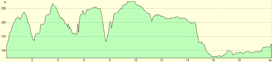
For more information on profiles, ascents and descents, see this page
Disclaimer
Please note that I take no responsibility for anything that may happen when following these directions. If you intend to follow this route, then please use the relevant maps and check the route out before you go out. As always when walking, use common sense and you should be fine.
If you find any information on any of these routes that is inaccurate, or you wish to add anything, then please email me.
All images on this site are © of the author. Any reproduction, retransmissions, or republication of all or part of any document found on this site is expressly prohibited, unless the author has explicitly granted its prior written consent to so reproduce, retransmit, or republish the material. All other rights reserved.
Although this site includes links providing convenient direct access to other Internet sites, I do not endorse, approve, certify or make warranties or representations as to the accuracy of the information on these sites.
And finally, enjoy your walking!
Nearby walks
| # | Title | Walk length (miles) |
|---|---|---|
| 644 | A walk between Clare and Long Melford | 19.6 |
| 694 | A circular walk from Clare to Suffolk county top | 19.6 |
| 699 | Sudbury to Marks Tey | 17.1 |
|
|

|