Walk #503: Kinloch Hourn to Glenelg
 |
 |
|
General Data
| Date Walked | 19/07/2003 |
| County | Highlands |
| Start Location | Kinloch Hourn |
| End Location | Glenelg |
| Start time | 09.55 |
| End time | 17.53 |
| Distance | 19.9 miles |
| Description | This was an absolutely superb walk, the first half being along tracks and paths and the second half along quiet roads. |
| Pack | Today I carried my 30-litre Karrimor HotRock rucksack, which was filled with my packed lunch, waterproof leggings, water bottle and a couple of spare shirts, together with the usual assortment of odds and ends. |
| Condition | I feel absolutely fine after this walk, and have no significant problems to report. The undersides of my feet were aching before lunch, but once I had changed into my trainers they were fine. |
| Weather | Today's weather was very changeable; the morning was dominated by drizzle, there was a heavy shower of lunch and the after noon slowly became hot and sunny. |
| OS map | Landranger number 33 (Loch Alsh, Glen Shiel & Loch Hourn) |
 |
 |
|
 |
 |
|
Map of the walk
Maps courtesy of Google Maps. Route for indicative purposes only, and may have been plotted after the walk. Please let me have comments on what you think of this new format. For a detailed table of timings for this walk, please see the table file.
 |
 |
|
 |
Notes
I woke up this morning to the sound of rain drumming on Mervan's roof, a depressing sound at the best of times, but particularly when I have a mountain pass to climb over in the morning. I had not slept very well, and as a consequence I was exceedingly tires - seemingly more so than when I went to bed last night. Sam made me some coffee and porridge for breakfast, but I was in no hurry to set off on the walk.
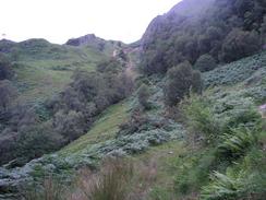
Sam had a long seventy-mile drive to do to get from Kinloch Hourn to Corran, so as soon as I set off she did as well to make the long drive around Loch Quioch. Almost immediately I was faced with a very stiff climb up a hillside, following a good track that skirted some high-tension power cables. The ascent soon had me puffing away like a steam train as I tried to make my way all the way to the top without stopping, and I eventually made my way up to the top and stood next to a pylon. Navigation for the next few miles was exceedingly easy, with the track winding around and up and down as it followed the pylons across the moorland. The views across to the high mountain summits on all sides were superb, but in many directions were spoilt by the pylons and cables. Drizzle was coming in from behind me, being blown in by the wind, but I was also very warm and I considered just taking my coat off and just getting wet - something I did not do in the end. The track was distinct and good going in most places, but in some it became slightly more indistinct and harder to find.
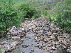
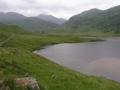
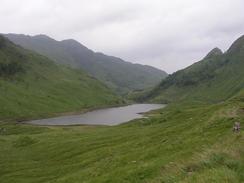
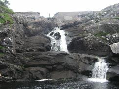
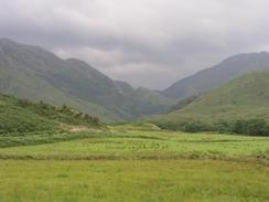
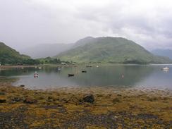
Eventually the track turned to the left to enter Gleann Dubh Lochainn and this steered me away from the pylons, which continued on northwestwards towards Skye. The track becomes larger and slowly descends to pass two lochs, Dubh Lochain, and then continues on under a dam and enters Glen Arnisdale. A stiff climb over a little hill follows before a nice walk along the bank of the river follows, and eventually the track crosses the river and continues on along the northern bank for a little under a mile until it reached the road. I was unsure about whether Sam would be at the end of the road, so I walked south for a quarter of a mile to the car park at Corran. Mervan was not there, and so I walked back and continued on for a mile into Arnisdale, and at the far end of the village I sat down on a pile of blocks for lunch. A few minutes later Sam turned up, and I piled into Mervan for lunch.
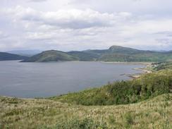
The views over the summit of Beinn Sgritheall at 974 metres were superb, and I just wanted to go and climb the hill - it made a great backdrop for lunch. Just as I was about to set off again it started to rain hard, and so I decided to delay my start until it was over. Fortunately it only lasted for half an hour, and I restarted the walk with my coat in my bag due to the heat. From a high point immediately to the west of Arnisdale I got a good view of the northern coast of Knoydart, and this made me very glad that I had not walked around that stretch of coastline - there is no path, and it looks like quite a difficult walk, with several cliffs to be walked around.
Due to my late start and long lunch I was keen to press on, and I tried to keep up a fast pace on the road walk around to Glenelg. There were several sharp ascents, but I managed to keep up a good pace on this stretch. The views were absolutely superb, and when the sun came out the mountains of Skye were just calling out to be climbed. All this made what should have been a long and boring road plod interesting, and the time just flew by and I reached Glenelg earlier than I had been expecting.
Sam had got permission to park in the car park of the Glenelg Inn, and as soon as I arrived there I asked Sam if she wanted a drink - I was desperate to go to the toilet, and quenching my thirst would also kill two birds with one stone. Once we were in there I sank down to pints of orange and lemonade quite quickly as I was far thirstier than I had realised, and after this we decided to have dinner in the inn. I had a superb lamb shank with mash and butter beans, and this helped fill the empty space in my stomach.
Directions
This walk starts off at the car park in Kinloch Hourn. Head southeastwards along the road past the cafe and farm, and then turn left to cross a river and follow a track as it turns to the left past a campsite to head northwestwards toward the end of the loch. When a white gate is reached go through it and continue along the track through a pleasant garden. The track passes some houses and then starts to climb steeply uphill and fairly soon comes across some power cables. The track heads uphill under these cables, and eventually it reaches the top of the hill. The track continues on northwestwards, roughly following the power lines across the hills, losing and gaining height across some nice moorland. Eventually after a few miles the track reaches a river, which it crosses to get to the northern bank, and the track then turns to the left to head beside the river in a rough westerly direction down Gleann Dubh Lochainn as the power lines continue on to the northwest.
Follow the track westwards as it heads downhill, eventually passing two lochs and crossing the river underneath the dam of the westernmost one. The track then climbs steeply uphill for a short distance and then descends downhill to meet the valley floor of the River Arnisdale. Follow the track along the southern bank of the river until a bridge over the river is met. Cross the bridge and on the northern side follow the track as it turns to the left and heads westwards for a mile until it reaches a road immediately to the north of Corran.
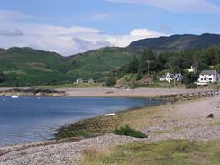
Turn to the right and head northwards along the road through Arnisdale and onwards as it climbs uphill. The road climbs and descends several times as it slowly curves around the end of the peninsular, but it eventually passes Mam nan Uranan and descends down to the bridge over the Abhainn a Ghlinne Bhig at Eilanreach. Follow the road as it turns to the left on the northern side of the bridge and continue on along the road for a little over a mile into the village of Glenelg, where this walk ends in the car park of the Glenelg Inn.
Distances
| From | To | Distance (m) | Ascent (ft) | Descent (ft) |
|---|---|---|---|---|
| Kinloch Hourn car park | Corran | 9.1 | 1893 | 1913 |
| Corran | Glenelg | 10.8 | 1778 | 1739 |
This makes a total distance of 19.9 miles, with 3671 feet of ascent and 3652 feet of descent.
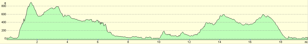
For more information on profiles, ascents and descents, see this page
Accommodation
We spent the night in the car park of the Glenelg Inn, who were kind enough to let us spend the night there.
Disclaimer
Please note that I take no responsibility for anything that may happen when following these directions. If you intend to follow this route, then please use the relevant maps and check the route out before you go out. As always when walking, use common sense and you should be fine.
If you find any information on any of these routes that is inaccurate, or you wish to add anything, then please email me.
All images on this site are © of the author. Any reproduction, retransmissions, or republication of all or part of any document found on this site is expressly prohibited, unless the author has explicitly granted its prior written consent to so reproduce, retransmit, or republish the material. All other rights reserved.
Although this site includes links providing convenient direct access to other Internet sites, I do not endorse, approve, certify or make warranties or representations as to the accuracy of the information on these sites.
And finally, enjoy your walking!
This walk was mentioned in the following routes:
| My walk around the coastline of Britain |
Nearby walks
| # | Title | Walk length (miles) |
|---|---|---|
| 502 | Inverie to Kinloch Hourn | 15.1 |
| 504 | Glenelg to Morvich | 18.0 |
| 505 | Morvich to Kyle of Lochalsh | 15.6 |
|
|

|