Walk #505: Morvich to Kyle of Lochalsh
 |
 |
|
General Data
| Date Walked | 21/07/2003 |
| County | Highlands |
| Start Location | Morvich |
| End Location | Kyle of Lochalsh |
| Start time | 10.22 |
| End time | 15.56 |
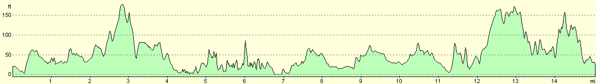
| Distance | 15.6 miles |
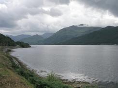
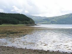
| Description | This was a nice plod along the A87(T), beside Loch Duich and Loch Alsh. |
| Pack | I carried no pack today, and wore my coat with all my main equipment in the pockets. |
| Condition | My right shoulder and neck were aching after this walk, for the first time in a week. This corresponds to me having my GPS unit hanging around my neck, and so I assume that the problem occurs only when I have things hanging from my neck. |
| Weather | Today was mainly a sunny day without much wind, but there was an extremely heavy shower towards the end of the walk that soaked me to the skin. |
| OS map | Landranger number 33 (Loch Alsh, Glen Shiel & Loch Hourn) |
 |
 |
|
 |
 |
|
Map of the walk
Maps courtesy of Google Maps. Route for indicative purposes only, and may have been plotted after the walk. Please let me have comments on what you think of this new format. For a detailed table of timings for this walk, please see the table file.
Notes
It was another late start today, as I spent some time doing some work on my website whilst I had access to mains electricity. I was quite looking forward to the walk, although the weather forecast was not too good - occasional heavy rain and thunderstorms, with sunny spells. I waited for a shower to finish before finally setting off from the campsite and starting the long walk along the A78(T), which was far from the most interesting walk in the world. To keep myself amused I started writing a story in my head - going into my own little dream world whilst still keeping one eye on the traffic that roared past. The views from the initial stretch of road were not that great, as the road was a little distance away from the road, and trees blocked the views, which was a shame.
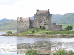
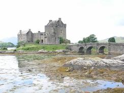
I had been looking forward to seeing Eilean Donan Castle close up - I had seen it from across Loch Duich yesterday, The castle looks absolutely superb and is situated on a tiny island, linked to the mainland by a causeway and bridge. It has a colourful history; King Alexander II of Scotland built it in 1220, and in 1719 it was bombarded and severely damaged by an English warship whilst being held by Jacobites. The castle was rebuilt in 1932 at a cost of £230,000 (a snip at modern prices), and thus is hardly original. I did not really want to sped the time looking inside the castle today, so I satisfied myself by taking pictures from the outside. I then met Sam for lunch in the castle's car park, and we went into the shop for a look around. The sight of all these Munros over the last few weeks have really caught my fancy, and so I bought myself a copy of Cameron McNeish's book on the Munros - not that I want to climb them all, but there may be a choice one or two that appeal to me, and the book details routes for each one.
A couple of miles before the end of this walk I reached the Murchison Memorial, which is on top of a small cliff below the road. I had to follow a vague pat through some woodland to get there, a trip I made as the memorial is marked on the map and I was curious to see what it was. The memorial turned out to be an obelisk that had ben erected in 1863 in memory of Donald Murchison, colonel in the Highland Army of 1715. He successfully defended and faithfully preserved the lands of Kintail and Lochalsh from 1715 to 1722 for his chief William, the exiled Earl of Seaforth. hence even this far north there are memories and signs of the 1715 and 1745 rebellions that changed the history of Scotland in such a major way.
About five minutes before I reached Kyle of Lochalsh it suddenly started to rain from a very grey cloud. The raindrops were extremely large and the impact of each one could be felt. It took me about a minute to do my coat up, and in that time the front of me was soaked as the rain was coming in from in front of me. Within a couple of minutes my trousers were drenched, and I was utterly bemused by the sudden change in the weather. The rain only lasted a few minutes, and by the time I reached Mervan it had stopped. I had intended to walk for a couple of hours more, but as I was soaked I decided to finish early after a very short day. The rest of the afternoon remained dry and sunny, and despite this I was quite content with finishing the walk early, as I wanted to relax.
Because I finished the walk early I changed into dry clothes and we went for a walk around the town. The harbour area is quite nice, and we spent some time looking at the boats there, including the glass-bottomed boat that does tours of the area. My last pair of Walkman earphones had broken, and so we were looking for somewhere to get a new pair. Eventually we found a pair, and afterwards we retired to the Kyle Hotel for a couple of drinks and games of pool. The alcohol went straight to my head, and I decided it would be distinctly unwise to have any more. Kyle of Lochalsh is the terminus of the long Inverness to Kyle railway line, and this line made the town into a tourist centre. Although it is less important today than it used to be, and it was threatened with closure in 1971, the line is still open and is apparently a superbly scenic journey. We also nipped into the tourist information office, and I came across a guidebook detailing a 360-mile walk around the coastline of the Isle of Skye. This was extremely tempting, but with regret I had to decided not to extend the walk - the end date of the walk is now fixed, and I cannot afford a three week extension, as I doubt that I would be able to make the time up in the two months left.
Due to the short day today I will probably have to do a longer walk tomorrow, but that thought does not fill me with dread. The roads should well be quieter than today's (which were hardly the busiest that I have seen), and there should be some nice villages to be passed through on the way. I have a great deal of road walking facing me over the next few days, but unfortunately most of this is unavoidable, and I shall have to grin and bear it.
Directions
This walk starts off at the campsite at Morvich, a couple of miles northeast of Shiel Bridge. Leave the campsite and turn right to walk along the road for a couple of hundred yards until a T-junction is reached. Turn right at the junction to cross Croe Bridge, and follow the road as it curves around to the left and continues westwards for a mile until it ends at the A78(T) road.
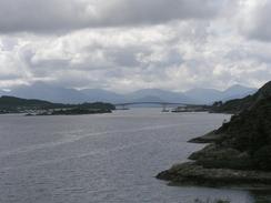
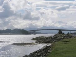
Turn right and follow the A78(T) as it heads northwestwards along the northern bank of Loch Duich. Near Dornie the road passes the spectacular Eilean Donan castle before crossing Loch Long on a concrete bridge. On the northern side of the bridge continue on for a couple of hundred yards and then turn left along a road that heads through Ardelve for under a mile before ending at the A78(T) once more. Turn left and walk along the A78(T) westwards for about seven and a half miles into Kyle of Lochalsh. This walk ends in a car park by the railway station in the town.
Distances
| From | To | Distance (m) | Ascent (ft) | Descent (ft) |
|---|---|---|---|---|
| Morvich | Dornie | 6.7 | 1001 | 1004 |
| Dornie | Kyle of Lochalsh | 8.9 | 984 | 978 |
This makes a total distance of 15.6 miles, with 1985 feet of ascent and 1982 feet of descent.
For more information on profiles, ascents and descents, see this page
Accommodation
We parked Mervan in a car park in the centre of Kyle of Lochalsh, immediately above the railway station. This was very handy for all the facilities, including some public toilets and the local pubs.
Disclaimer
Please note that I take no responsibility for anything that may happen when following these directions. If you intend to follow this route, then please use the relevant maps and check the route out before you go out. As always when walking, use common sense and you should be fine.
If you find any information on any of these routes that is inaccurate, or you wish to add anything, then please email me.
All images on this site are © of the author. Any reproduction, retransmissions, or republication of all or part of any document found on this site is expressly prohibited, unless the author has explicitly granted its prior written consent to so reproduce, retransmit, or republish the material. All other rights reserved.
Although this site includes links providing convenient direct access to other Internet sites, I do not endorse, approve, certify or make warranties or representations as to the accuracy of the information on these sites.
And finally, enjoy your walking!
This walk was mentioned in the following routes:
| My walk around the coastline of Britain |
Nearby walks
| # | Title | Walk length (miles) |
|---|---|---|
| 503 | Kinloch Hourn to Glenelg | 19.9 |
| 504 | Glenelg to Morvich | 18.0 |
| 506 | Kyle of Lochalsh to Strathcarron | 19.7 |
|
|

|