Walk #846: A circular walk from Swanage to Corfe Castle
 |
 |
|
General Data
| Date Walked | 15/03/2010 |
| County | Dorset |
| Start Location | Swanage |
| End Location | Swanage |
| Start time | 09.42 |
| End time | 15.37 |
| Distance | 14.8 miles |
| Description | This was an exceptionally good walk along the Purbeck Hills from the sea to Corfe Castle. |
| Pack | Today I carried my 30-litre Karrimor rucksack, filled with waterproofs, a book and other odds and ends. I also carried three litres of water. This was by far the heaviest pack that I have carried for some time. |
| Condition | I am fairly fine after this walk; I had little trouble with my feet, which is a relief after the troubles and blisters that have plagued me over the last three or four walks. |
| Weather | Today was a beautiful, sunny day, with little cloud to spoilt things. There we a stiff, chilly breeze at times. |
| OS map | Landranger number 195 (Bournemouth & Purbeck, Wimborne Minster & Ringwood) |
 |
 |
|
 |
 |
|
Map of the walk
Maps courtesy of Google Maps. Route for indicative purposes only, and may have been plotted after the walk. Please let me have comments on what you think of this new format. For a detailed table of timings for this walk, please see the table file.
 |
 |
|
 |
 |
|
Notes
Today's weather forecast was for unbroken sunshine, and I fancied doing a walk near the coast. The coastline nearest my home in Romsey is pleasant but hardly spectacular, so I decided to go a little further afield. I have walked the coastline to the east around Portsmouth since my coastal walk, so instead I headed further west. When I first walked the start of the South West Coast Path I noticed the superb ridgeline of the Purbeck Hills running inland; later, when I rewalked that section with Sencan, I noticed them again. The good weather made it seem like a perfect day to walk this path.
I had intended to park at Corfe Castle and walk eastwards along the ridge towards the sea; however, when I reached the village it turned out that the Norden park-and-ride was shut, and the main car park only allowed a maximum four-hour stay. I drove through the village itself and could not see any signs for long-stay car parks, so instead I continued onwards towards Swanage, where I knew there were many long-stay car parks. One of these - pleasantly near the centre of town - cost only £1.50 for the entire day.
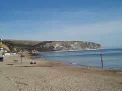
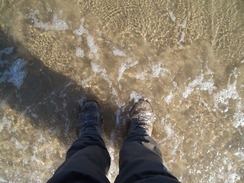
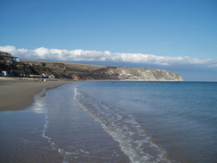
The sun shone gloriously down on me as I headed towards the sandy beach and strolled through the surf. It was glorious weather, more akin to mid-summer than mid-March. It was fairly warm, the only downside being a chilly, cutting wind. Having wetted my boots, I rejoined the promenade and headed north, following the South West Coast Path. Ahead was the massive chalk ridge of Ballard Down. Unfortunately a long and fairly boring road walk took me on towards it.
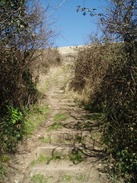
It was therefore a relief when the roads were left behind me and the SWCP started following the top of the cliffs. A little steep-sided gully had to be negotiated, after which the ascent up onto Ballard Down started. This was steep with steps in places, and soon I was feeling rather hot - a first for this year. The views out to sea were superb - a boat made its way past as I climbed.
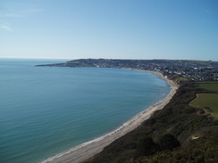
Soon I felt the SWCP and headed further uphill onto the Down, meeting the Purbeck Way. My main route was to head westwards along the ridge, but first I headed eastwards towards the trig pillar on top of the Down. On the way I got a superb view down to the left over Poole Harbour, and to the right over Swanage Bay. Ahead, just visible through the distant haze, were the white cliffs of the Isle of Wight. The alignment was so perfect that I wondered if the Needles and the cliffs on the island were an extension of the Purbeck Hills, the intervening land having been claimed by the sea.
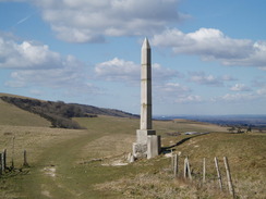
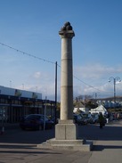
Once at the trig pillar I headed back westwards along Ballard Down. Several dog walkers, cyclists and joggers passed me during the gentle climb, and the views in virtually all directions were superb. Eventually the broad crest of the hill was reached, after which the descent down was steeper between hedges. Soon an obelisk became visible ahead - this seemed to be in a slightly patchy, dishevelled condition and it soon became obvious that it had been heavily repaired. A plaque on the base of the obelisk explained why - the obelisk (built to commemorate the provision of a water supply to Swanage in 1892) had been pulled down during the Second World War to stop it being used as a navigational aid by enemy pilots. It was rebuilt by the army after the war, but one of the sections was found to be too badly cracked to be used, and this now sits by the base.
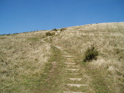
A long descent down to a quiet road followed. A wide verge helped me avoid the few cars that passed as it headed downhill, until a stile led me past some cows and the start of the ascent up onto Nine Barrow Down. This followed a track; after a short distance another track led off to the left, a so-called Underhill' path that would lead all the way to Corfe Castle. Whilst this path looked interesting, I wanted to walk the ridge, so I continued uphill.
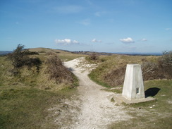
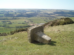
A trig pillar is marked on the map near the top of Nine Barrows Down, but as the track approached the top I saw a large lump of concrete that looked ominously like the base of a pillar. Sure enough it was the pillar, looking very dejected as it lay on its side. The brasswork (the spider on the top and the flush bracket) had been removed, as had the Ordnance Survey GPS plaque. It was a sad sight.
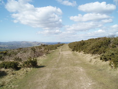
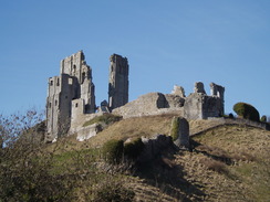
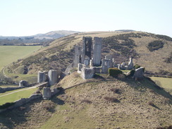
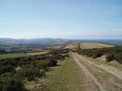
The next stretch of walk really helped cheer me up, however. The path ran right along the top of the hill, slowly descending in height as it passed a series of barrows. Intermittent views were superb, including, in place, glimpses of the ruins of Corfe Castle, the grey, shattered stonework sticking up like fingers into the sky. Many other people were out and about, and it was obvious that the path was deservedly well-walked.
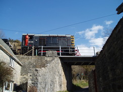
Slowly the path started to descend as it headed towards a large aerial on the hill. Shortly after this a signpost indicated a permissive path across to East Hill, directly beside Corfe Castle. As there was no indication that you could descend down to the village from there, I kept on the main path, which followed a track in a long descent down to meet a lane. I passed a small car park signposted for walkers - a handy thing to know, and a final descent started. Just before a bridge under the Swanage Railway I found a permissive footpath leading up onto East Hill - the end of the footpath signposted on the aerial.
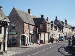
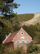
A works train passed over the railway bridge as I passed; a class 08 shunter hauling a few wagons. I then made my way into the centre of the beautiful town of Corfe Castle.This seemed like as good a place as any to stop, so I headed into the first pub that I could find. I was slightly uneasy at first as the interior was very smart, but I was made welcome as I ordered a pint of Doom Bar and another of orange and lemonade. One of the staff approached me as I supped - he had walked the South West Coast Path before, and we chatted about walking for a while before, reluctantly, I had to set off once more.
It was tempting to make a diversion to climb West Hill on the other side of Swanage, but time was pressing - a late start and the need to pick Sencan up from work meant that I could not be too tardy. Instead, I decided to take the path that led up to East Hill. An ominous-looking warning sign at the bottom was duly ignored, and I set off up the hill. It was so steep that the majority of the ascent was stepped, although in a couple of places steps were missing - this section could be slippery in wet weather. Before I knew it I was at the top, with some superb views over towards the ruins of the castle.
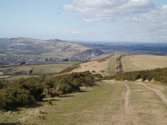
It was then simply a case of following my tracks back to the road at the bottom of Nine Barrows Down. The weather was fine and the path was fairly busy, including a highly energetic party of children, complete with kite! My last few walks have been dominated by pain from my feet, and it was a relief that these problems were not recurring. It was a slow, gentle climb up to the top of the Down, after which I passed the recumbent trig and started the descent down to the road. There were some superb views eastwards from the top of the track; the early-morning haze had risen, and been replaced with clear views, the white cliffs of the Isle of Wight shining in the distance.
At the road I had a choice of alternatives; I could have reclimbed up onto Ballard Down and returned to Swanage from there, but as I felt pressed for time the more direct route via the road felt best. It was a fairly uninteresting stroll after the literal and metaphorical highs of earlier, and it was a relief when the beach was reached. The tide was out, and instead of following the promenade I walked down into the surf and followed the surfline as far as I could to the south. Then I rejoined the promenade and walked back to my car. It had been a superb day's walk, one of the best that I have had for some time. I shall have to repeat this walk soon.
 |
 |
|
 |
 |
|
Directions
This walk starts off at the Main Beach car park in Swanage, just off the A351 road in the town, and near to the railway station. Leave the car par and turn right to head towards the beach, reaching it near the pier. Turn left to start following the promenade northwards in company with the South West Coast Path. When the promenade ends continue on along the road as it heads uphill, angling slightly inland from the sea. When a complex road junction is reached at SZ029802 near a shop, turn right and continue along the South West Coast Path as it heads along a road. It then turns to the left and then down a path to the right to reach the top of the cliffs.
Turn left and start following the path northeastwards. It descends to cross a steep-sided gully, then follows two winding hedges until it reaches the steepest section. Steps then lead uphill, again in company with the South West Coast Path. When the national trail heads off to the right near the top, continue straight on uphill to reach the Purbeck Way at the top. If you wish to visit the Ballard Down trig pillar then go right through a gate to head eastwards for a third of a mile to reach the pillar; if not, then turn left to start climbing westwards up the ridge line.
The summit is soon reached, after which the path joins a track and starts descending between hedges to reach an obelisk. Shortly after this the path turns to the right and heads down to end at a road. Turn left along this road and follow it as it descends, heading downhill as it curves to take a more southerly course. Soon a road comes in from the left; immediately after this cross a stile on the right to join a footpath that heads southwards to join a track.
Follow this track as it heads uphill westwards onto Nine Barrows Down. It curves to the right, then sharply to the left before levelling off. From here, walk for two and a half miles westwards along the crest of the hill. The path slowly descends before reaching an aerial. Here you have a choice; you can continue along a permissive path to the top of East Hill, from where a steep set of steps leads down towards Corfe Castle. Alternatively, join a track that heads downhill westwards. This slowly descends before meeting a road. Follow this road as it continues to fall downhill. The path leading down from East Hill joins the road just before it dives under a bridge under a railway line. When the A351 is reached by the base of Corfe Castle, turn left to head carefully up the road into the village.
To head back, retrace your steps to climb up onto the Purbeck Hills, using either the track or the steps that lead up onto West Hill. From there head eastwards, slowly climbing up onto Nine Barrows Down and then descend down the track to reach the road near Ulwell. From here, turn right and start following the road southeastwards. After about a mile it rejoins the South West Coast Path near the shop. From here it is simply a case of retracing your steps from earlier in the day, following the road down into Swanage. I extended the walk slightly be following the beach southwards before turning back along the promenade; you can take whatever route you like.
Distances
| From | To | Distance (m) | Ascent (ft) | Descent (ft) |
|---|---|---|---|---|
| Swanage | Ballard Down | 2.4 | 581 | 220 |
| Ballard Down | Corfe Castle | 6.0 | 768 | 1066 |
| Corfe Castle | Swanage | 6.4 | 793 | 856 |
This makes a total distance of miles, with 2143 feet of ascent and 2142 feet of descent.
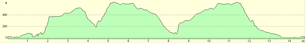
For more information on profiles, ascents and descents, see this page
 |
 |
|
 |
 |
|
 |
 |
|
Disclaimer
Please note that I take no responsibility for anything that may happen when following these directions. If you intend to follow this route, then please use the relevant maps and check the route out before you go out. As always when walking, use common sense and you should be fine.
If you find any information on any of these routes that is inaccurate, or you wish to add anything, then please email me.
All images on this site are © of the author. Any reproduction, retransmissions, or republication of all or part of any document found on this site is expressly prohibited, unless the author has explicitly granted its prior written consent to so reproduce, retransmit, or republish the material. All other rights reserved.
Although this site includes links providing convenient direct access to other Internet sites, I do not endorse, approve, certify or make warranties or representations as to the accuracy of the information on these sites.
And finally, enjoy your walking!
Nearby walks
| # | Title | Walk length (miles) |
|---|---|---|
| 312 | Southbourne to Hamworthy Station | 15.3 |
| 313 | Hamworthy Station to South Haven Point | 18.0 |
| 314 | South Haven Point to Worth Matravers | 16.7 |
|
|

|