Walk #609: Haslemere to Liphook
 |
 |
|
General Data
| Date Walked | 13/06/2004 |
| County | Surrey, West Sussex, Hampshire |
| Start Location | Haslemere |
| End Location | Liphook |
| Start time | 08.08 |
| End time | 15.04 |
| Distance | 18.3 miles |
| Description | This was quite a nice little walk, taking in West Sussex's highest point on the way. |
| Pack | Today I carried my 30-litre Karrimor HotRock rucksack, which was filled with my waterproof leggings, water bottle, trainers and a couple of spare shirts, together with the usual assortment of odds and ends. It weighed slightly more than usual as I also carried a couple of litres of extra water. |
| Condition | I am quite tired after this walk, and I have a couple of blisters in this usual place on my little toes. This was my first walk for nearly a month, so I am quite glad that I managed as well as I did. |
| Weather | Today was a lovely day; it was quite hot, and although the skies were initially cloudless it slowly clouded over as the day went on. There was a slight breeze to help me cool down, and there was absolutely no sight of any rain. |
| OS map | Landranger number 186 (Aldershot & Guildford, Camberley & Haslemere) |
 |
 |
|
 |
 |
|
Map of the walk
Maps courtesy of Google Maps. Route for indicative purposes only, and may have been plotted after the walk. Please let me have comments on what you think of this new format. For a detailed table of timings for this walk, please see the table file.
Notes
I was slightly nervous before setting off on this walk, as I had not done a walk for nearly a month and yesterday I had a great deal of pain from my bad left ankle - the sort of pain I have not had since the last operation in 1998. Understandably the return of old pain made me very nervous indeed, but when I woke up this morning it felt okay, if slightly numb, and so I decided to set off on the planned walk. Fortunately the route I planned was circular and would allow me to cut the walk short if I needed to, and so I was confident that if I did have more trouble that I would be able to get out of it.
The drive down to Haslemere and the start of the walk went well, and it felt quite strange to wake up at five in the morning to bright sunshine - summer is definitely here. I parked the car in the car park at Haslemere Station (parking is free on Sunday) and I put my kit on, making doubly sure that my left boot was very tightly laced up to try and support the ankle, and set off on the walk. Initially I passed through the outskirts of Haslemere, avoiding the city centre as I headed uphill to find the course of the Greensand Way, which I was to follow for a short distance.
The Greensand Way joined a track that allowed access to houses as it headed northwestwards, and towards the end of this access track I discovered that I could not find the place where the Way continued on; the track just ended in a series of private roads. Fortunately I found the Greensand Way a few yards down the track, where it headed uphill along a little sunken track. As I set off along this I met another gentleman who was walking the Greensand Way, and we chatted as we headed up the hill. This was not too steep, but after a month without walking I was out of condition and I found the walk quite hard going, and I was soon panting for breath in between sentences.
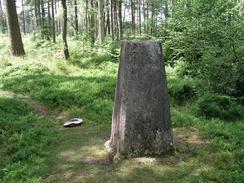
It was nice to chat to someone, and I was sad when I left the Greensand Way and continued uphill towards the summit of Gibbet Hill along a track. This was broad and the going was easy, and I soon found myself at the trig point. Many plaques, including a National Trust crest and an Ordnance Survey GPS plaque, festooned this and nearby there was another monument in the form of a cross, although I could not read the engraved inscriptions. I had been expecting the views from the top of the hill to be expansive but unfortunately the woodland encroached on the views, allowing only a short stretch of view to be made northwards.
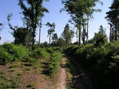
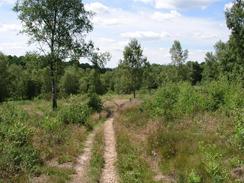
I spent a few minutes at the trig point before starting the descent down off the hill. Initially I followed the track that I had climbed up, before diverting off to the left and heading eastwards along forestry tracks. I found this section of the walk to be quite enjoyable, and although the trees blocked the view for the majority of the time the occasionally snatched views were very much worth waiting for. The track entered a clearing where the air was full of the smell of pine from the piles of cut timber that lined the side of the track. This added to the atmosphere, and I had a spring in my step as I descended down to the A286 road in Grayswood.
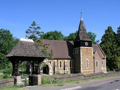
Grayswood was an attractive little village, and it seemed like half the village were either walking to the church or sitting around on the village green, which was replete with a cricket pitch. I was tempted to stop and have a look around, but my feet persuaded me to walk on out of the village towards my next target, the trig point on Clammer Hill. This was on private land, but I found an easy way to skirt around the base of the hill before climbing up to the pillar, which was surrounded by a strange wooden platform. I did not want to stay too long, so I headed back down to the road and then headed southwards to the B2131 road.
I only followed this road for a short distance before diving off to the right, following a track that passed through the grounds of a hotel whilst heading downhill. After this it slowly headed uphill, the bridleway leaving the track at a cottage and the views becoming more expansive across the fields as I slowly climbed. Fairly soon another road was reached near Barfold, and I joined this to continue the walk southwards. When I reached Shopp Hill I started a climb up another road quite steeply uphill; indeed it was so steep that I was soon out of breath, which is yet another sign that I am not as fit as I used to be, and I found myself promising never to leave a month between walks again.
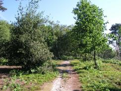
I was relieved when I finally left the road and could start walking northwards, following a bridleway that ran along a deep, rutted track. My target was the summit of Black Down, where a trig point marks the highest point in West Sussex. The pillar is slightly to the west of the bridleway, and so when I reached the correct point I climbed uphill a short distance to the west through the trees, and was more than a little pleased when I precisely reached the pillar, which nested in a little glade amongst the trees. I was fairly tired by this time, and so I decide that it would be a good opportunity to rest and have my lunch, so I sat down with the cool side of the pillar acting as a backrest.
As nice as it may have been I could not sit around forever, so after fifteen minutes I got up and took a panorama from the trig point; unfortunately the trees obscured any views from this county top. I then packed away my tripod and set off back towards the track that would lead me down off the hill. For the rest of the day I would be following the Sussex Border Path, and this was a little relief as it made navigation much easier as it was well signposted. The walk was quite enjoyable but I was getting quite hungry and in need of some refreshment when I came across what I thought at first might be a mirage. Set up on the track outside a house were two tables staffed by three young children; one table selling juice and one selling ice cream for charity, sheltered from the bright sun by a striped umbrella. I started chatting to the children, and they offered me an ice cream for free as I was the first customer of the day. I was so charmed by this that I gave them a pound for the ice cream, double the price, and I chatted to them for a few minutes before setting off once again, made much happier by the refreshment and the meeting. It was so nice to realise that children could safely run such a stall outside their houses, and they were very charming. The stop refreshed my soul as much as my body.
It had been my intention to double back on myself and head towards Haslemere Station and the car, but I quite fancied altering my plans so that I would end at Liphook Station. I had no idea about the train times, so I phone Sam up and she gave me the news that there were trains every hour, so I decided to change my route. By this time the Sussex Border Path was plunging through the trees, and I followed a series of tracks through the woodland as it wound around in a generally westwards direction. Eventually I emerged out at a road that I followed down to Liphook Station, and I was glad to see that I arrived about fifteen minutes before the train was due. I purchased my ticket, but then a man came out to tell me that the trains were not stopping at Liphook today due to a fire in Southampton. Whilst this could have been exceptionally annoying the staff were very well organised and a few minutes before the train was due I found myself in a taxi, and I arrived back at Haslemere Station with no delay from if I had caught the train. All I can say is thanks to the staff at the station, who were superb in organising the taxis for all the waiting passengers, and I am pleased to say it cost me no extra over the normal ticket price.
Directions
This walk starts off at Haslemere railway station, which is situated in the centre of the town. Leave the station via the approach road and then turn to the right to head down a slight dip under a railway bridge. Once on the other side of the bridge turn right to head uphill along Weydown Road until a hundred yards before the junction with High Lane is reached on the right, where a footpath leads off to the left. This footpath is part of the Greensand Way, and it can be followed as it heads northwestwards, initially past a field before ending at a track. Turn left for a few yards and then right up Stoatley Lane, which head uphill before ending at a series of driveways leading to private residences. Just before the track ends turn right up a sunken lane, which heads uphill before joining Farnham Lane. Continue northwards up Farnham Lane; when the Greensand Way dives off to the left continue straight on, and when the lane ends continue straight on uphill along a rough track.
The track eventually ends in a clearing at the top of Gibbet Hill, where there is a trig point and a monument. Once you have visited the pillar turn around and head back down the hill for a couple of hundred yards until a track leads off steeply downhill to the left. Take this footpath, and from here the directions have to become less verbose as there were several possible routes through the woodland. The route that I took headed northeasterly initially, before curving to head eastwards towards Hurthill Copse. It then heads southeastwards steeply downhill to another track, which can be followed as it curves to head northwards, after which another footpath leads off to the right to head southeastwards. Once leaving the woodland the path becomes a track, and once this heads under a bridge under a railway line follow it until it ends at the A286 road immediately to the north of the village of Grayswood.
Once the A286 is reached turn right, and follow the road southwards for a couple of hundred yards towards the village church, and then turn left to head southeastwards along another road. The road leaves the village and then curves to head in a more southerly direction, skirting to the west of Clammer Hill, on top of which is another trig point. Continue on along this road for a little over a mile until it ends at the B2131 road on Lythe Hill, and then turn left and carefully follow the road eastwards (there is no pavement) for a few hundred yards until a hotel is reached on the right. Turn right and walk through the centre of the hotel complex, following a footpath that goes through the grounds. When the path passes the hotel car park it heads downhill along a track, passing a little pond before heading uphill and turning to the left to end at cottage by High Barn Farm. When the track ends a bridleway continues on in a southeasterly direction, crossing the Surrey / West Sussex border before ending at a road near Barfold.
At the road turn left and follow the road for a short distance downhill until it reaches a junction with another road, and then turn right to walk southwards for a couple of kilometres towards Shopp Hill. When a road junction is reached on the right turn right and follow this new road as it curves around steeply uphill to the northwest. Once a track is reached on the right just past the final left-hand curve turn right up a track, which started to head northwards uphill towards Black Down. After a little under half a mile, when the bank on the left lowers down to almost the same level as the track, turn left and walk through the woodland for a short distance to the trig point pillar that marks the highest point in West Sussex. Once you have visited the pillar, return back to the track and then continue on along it in a northerly direction for about half a kilometre until the Sussex Border Path is reached. Once it is, turn to the left and start following this path, which will be followed until very nearly the end of the walk.
The Sussex Border Path initially follows a series of rough tracks in a rough northwesterly direction, before settling onto a westerly course along access tracks to houses and bridleways to reach the A286 road. At this road follow the Sussex Border Path as it turns to the right for a few yards; just before another road comes in from the right turn left along a bridleway that heads steeply uphill onto Marley Common. The bridleway is easy to follow as it crosses the common, and when a road is reached by a little car park continue on along the waymarked path. The path meets a road just to the north of the little village of Linchmere; turn right along the road for a couple of hundred yards before turning to the left and following tracks westwards. The path winds around, initially heading westwards, then southwards, southwestwards, and finally westwards before meeting a road. At this road turn left and then almost immediately right, to head northwestwards for nearly a kilometre towards the centre of Liphook. Once the road crosses over the railway line on a bridge, turn to the left, and then to the left once more, to access Liphook Railway Station, where this walk ends.
Distances
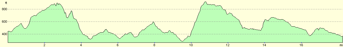
| From | To | Distance (m) | Ascent (ft) | Descent (ft) |
|---|---|---|---|---|
| Haslemere Station | Grayswood | 4.6 | 801 | 902 |
| Grayswood | Black Down | 6.2 | 1217 | 650 |
| Black Down | Liphook Station | 7.5 | 554 | 1099 |
This makes a total distance of 18.3 miles, with 2572 feet of ascent and 2651 feet of descent.
For more information on profiles, ascents and descents, see this page
Transport
There are regular (hourly on Sundays) train services from Liphook to Haslemere; a single ticket costs two pounds.
Disclaimer
Please note that I take no responsibility for anything that may happen when following these directions. If you intend to follow this route, then please use the relevant maps and check the route out before you go out. As always when walking, use common sense and you should be fine.
If you find any information on any of these routes that is inaccurate, or you wish to add anything, then please email me.
All images on this site are © of the author. Any reproduction, retransmissions, or republication of all or part of any document found on this site is expressly prohibited, unless the author has explicitly granted its prior written consent to so reproduce, retransmit, or republish the material. All other rights reserved.
Although this site includes links providing convenient direct access to other Internet sites, I do not endorse, approve, certify or make warranties or representations as to the accuracy of the information on these sites.
And finally, enjoy your walking!
Nearby walks
| # | Title | Walk length (miles) |
|---|