Walk #607: High Moor to Knaresborough
 |
 |
|
General Data
| Date Walked | 03/05/2004 |
| County | North Yorkshire |
| Start Location | High Moor |
| End Location | Knaresborough |
| Start time | 09.18 |
| End time | 13.59 |
| Distance | 10.6 miles |
| Description | This was a walk of two halves; a fairly boring stroll to the Nidd Viaduct was followed by an exhilarating and uplifting stroll through the Nidd Gorge. |
| Pack | Today I carried my 70-litre Craghoppers rucksack, filled with full camping kit, my Westwind tent, my Blue Kazoo sleeping bag and four days food. |
| Condition | When I finished this walk I was quite tired, the effects of the previous three days walks having caught up with me. However I soon recovered, and I believe that I could have walked much further today if I had needed to. |
| Weather | There was some heavy rain overnight and the outside of my tent was sodden when I woke up. However today was very different, with bright sunshine for much of the day and a slight breeze, although there were as couple of short and light showers as I walked alongside the River Nidd. All in all it was a lovely day for a walk. |
| OS map | Landranger number 104 (Leeds & Bradford, Harrogate & Ilkley) |
 |
 |
|
 |
Map of the walk
Maps courtesy of Google Maps. Route for indicative purposes only, and may have been plotted after the walk. Please let me have comments on what you think of this new format. For a detailed table of timings for this walk, please see the table file.
Notes
After the travails of yesterday I was mightily relieved when I woke up this morning and found that none of my bones or muscles ached. Last night I had not been able to walk due to seized muscles after lying down in my tent for a couple of hours, and so I was worried that the trouble may persist through the night. I got up and looked outside; overnight I had heard it raining, but now there was bright sunshine, which was a profound relief to me. I lay in my sleeping bag and flexed my legs up and down to check that I was getting no pain from them, and then got dressed and emerged from my tent. The campsite was really busy, as I would expect for a May Bank Holiday weekend, and I wandered past the massed ranks of caravans to the utilities block, gingerly testing my legs on the way. After doing my ablutions I ended up chatting to a gent in the dishwashing area for a quarter of an hour; for the first time on the trip I was in no hurry to set off, and wanted to exercise my body a little before putting my rucksack on.
For the same reason I took my time taking my tent down and packing up, enjoying the sunshine as I did so. It felt strange being on a site after two nights of wild camping, and it felt more so when I went to the little site shop to by some goodies before starting the walk - you generally do not get shops on the high moors! The route initially took me northwards along the driveway leading from the site towards the A59. This proved to be far busier than it had been last night, and so I immediately abandoned my plans to walk eastwards along the busy main road for a mile and instead took a minor road northwards for a short distance to a farm. The map shows a path heading across fields from here, but there was no sign of this at the farm where it started, and I ended up following a track across fields before eventually finding the stiles in the stone walls that took me across to another minor road.
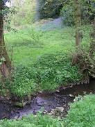
A driveway led to another farm and B&B; the map showed the footpath heading eastwards down to a stream but it was very hard to find the correct route on the ground and I ended up taking a slightly more northerly course. The stream was narrow and easy to cross, but the ascent up the other side to the stile at the top was very steep and I took it very carefully with my heavy pack on, hanging onto trees to help me up to the stile. Another field and some inquisitive cows later I reached another road that I followed to another, before following a track uphill to reach a trig point that was marked on the map. I fond it hard to find the trig point, but after a couple of minutes searching I found it embedded in a seemingly brand-new stone wall. Fortunately the flush bracket was not embedded in the wall, so I bagged the trig and took some photographs of it before heading back down to the road.
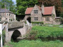
Another road walk took me down into the outskirts of Hampsthwaite and past a very attractive village sign before heading uphill once more to reach the B6161, which I had to wait a couple of minutes to cross sue to a seemingly endless stream of traffic heading north along it. Another kilometre along a road took me to the A61 and the northern outskirts of Harrogate; by this time I was getting fed up with the boring road walking, but there was an absolute jewel coming up. The dead-end lane that leads eastwards from the A61 ended by the Oak Beck and a lovely little bridge; together with the house opposite it made for a perfectly sylvan scene, despite being on the outskirts of a large town. I was tempted to go splashing about in the ford beside the bridge, which looked extremely tempting in the sunshine, but I resisted the temptation and plodded on uphill along the road.
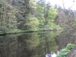
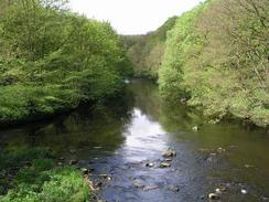
Fortunately I did not have to walk along too many roads before joining a footpath that headed down past a water treatment works to gain access to the southern bank of the River Nidd immediately below the Nidd Viaduct. The river flowing under this grand brick structure was a nice view, and I chose this spot to have my first rest of the day. A few people passed by me along this popular footpath before suddenly, in the sky above me, I saw a bent and tangled bicycle hanging from the branches of a tree. I stared at this for a while, and it seemed almost impossible for anyone to have climbed up to get it there; it must therefore have been thrown off the viaduct overhead, a very dangerous act. Eventually and reluctantly I got up and started following the path as it followed the southern bank of the river, winding around and occasionally heading high up the side of the Nidd Gorge.
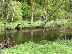
The views from the path were exhilarating and I was enjoying the walk so much that I slowed down so that I could soak in all of the views. I knew that it would be a short day and that I did not have to catch my train in Leeds until after five in the afternoon, so all time pressures were off me and I could afford to really take my time for the first time on the trip. Eventually I reached a little footbridge over the river, leading to the northern side of the gorge, and I crossed this so that I could follow the path on the northern bank of the river. As I reached the northern end of the bridge I saw a few children dragging a large inflatable boat down the bank to the river; they seemed to be fully prepared for an enjoyable afternoon mucking about on the river, and I envied them the ability to do that on such a fine day.
Once on the northern bank of the river I initially took a track that headed uphill, before taking a footpath that headed down the steep gorge side to reach an exquisite spot beside the river. There was a handy rustic bench here, so I sat down on this and watched the waters of the river slowly flow past me, a mesmerising experience. Eventually I shook myself out of the reverie and put my rucksack on to restart the walk along the footpath; this followed the river for another mile before heading up the valley side and reaching a road. This marked the end of the scenic Nidd Gorge, and I had a boring road walk for the last mile into the centre of Knaresborough. I had never been to the town before, and I found it to be a bustling place. I passed a lovely statue of a rider on a horse made out of branches; unfortunately someone had knocked the head off the rider recently, but it had since been replaced. I made my way to the station to find a train to Leeds ready to go; frantically I ran to a ticket machine only to find that it did not accept notes. Some passers by swapped coins for a note, and I jumped onto the train just before it pulled out of the station, leaving me with a long journey in which to think of the highs and lows, aches and strains of the last three and a half days walking.
Directions
This walk starts off at the High Moor Farm Caravan Park, just off the A59 road to the west of Harrogate. Leave the caravan park by heading northwards along the driveway towards the A59 road. Once at the A59 turn right along the A59 eastwards for a few yards, before crossing the road and heading north along a minor road. This road curves to the right and then the left, before reaching a farm on the right. Turn right to enter the farmyard and then take a footpath that heads southeastwards; this was hard to find on the ground but I followed a track that led away from the farm in seemingly the correct direction. Once the track peters out in a filed turn left and start walking northeastwards towards another farm; again, the footpath is indistinct although a few steps in the stone walls help guide the way to the end of a track, which in turn can be followed past the farm until it ends at another road.
At the road turn left and then right along the first driveway that you reach. This leads eastwards for a few yards into a courtyard, from where another footpath leads off down a hill to the east. Again, this footpath is indistinct, but basically head directly east from the buildings down to the stream at the bottom. Cross the stream, which is narrow and easy to jump across, and then go straight on up a very steep bank to a stile this was hard to do with a full pack, and I had to use the surrounding trees for support as I climbed. Once across the stile the going was easier across a field although the path was just as hard to find, and instead of trying to find the footpath I headed slightly southeastwards across the field to get to a gate that led straight onto a road.
The gate put me onto the road exactly opposite another road; if you manage to follow the footpath it will bring you out onto the road a little further north, so you would have to turn right and head south for a hundred yards to gain access to the road junction. Head straight on along the new road, which soon curves onto a northerly course before curving once more to head northeastwards; on Saltergate Hill to the right is a trig point, and this can be visited by going up a track to the right. Continue on along the road as it heads downhill to the north, before ending at a T-junction on the southern outskirts of Hampsthwaite.
Once at the junction turn right to walk southeastwards uphill; the road soon curves slightly to the left to head in a winding easterly direction past Levens Hall before ending at the B6161 road. Turn left and walk northeastwards along the B6161 for a few hundred yards until Grainbeck Lane leads off to the right; turn right and follow this road as it heads easterly and then southeasterly for a kilometre and ends at the A61 road. Turn right and follow the A61 southwards for a few yards before turning to the left down Knox Mill Lane, which soon ends at a small bridge over Oak Beck.
Cross this bridge and then turn slightly to the right to head uphill to the southeast along Knox Lane. Near the top of the hill, shortly after the road curves to the right, turn left down Bachelor Gardens, which heads northeastwards for a few hundred yards until a lane leads off downhill to the left. When this lane nears the gates of a sewerage works turn to the right along a footpath that heads eastwards, before turning to the left along another footpath that plunges downhill with the fence of the sewage works on the left.
The footpath reaches the valley floor beside the Nidd Viaduct, which towers overhead. Turn right and take the easy-to-follow footpath that heads along the southern bank of the river. It occasionally climbs high up above the river, but eventually reaches a footbridge over the river. Cross this bridge, and once on the other side turn to the right and follow the footpath eastwards along the northern bank of the river. A little over a mile later the footpath stops following the river and curves to the left to climb up a narrow path between garden fences to end at Lands Lane. Once at the road turn right and follow Lands Lane as it curves to the left and ends at a T-junction with the B6165 Ripley Road.
Turn right and start following the B6165 as it heads southeastwards, heading downhill before reaching the A59 Bond End in Knaresborough. Turn left and follow the A59 eastwards for a few yards until it curves sharply to the right to head southeastwards uphill. Continue on for a couple of hundred yards and then take the second road to the right, Station Road, which leads down to Knaresborough railway station, where this walk ends.
Distances
| From | To | Distance (m) | Ascent (ft) | Descent (ft) |
|---|---|---|---|---|
| High Moor Farm | Nidd Viaduct | 6.5 | 449 | 902 |
| Nidd Viaduct | Knaresborough Station | 4.1 | 548 | 535 |
This makes a total distance of 10.6 miles, with 997 feet of ascent and 1437 feet of descent.
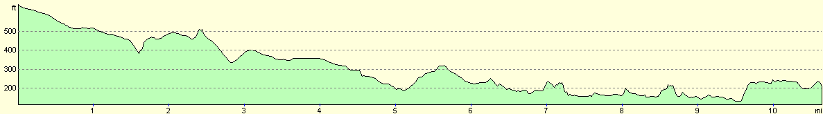
For more information on profiles, ascents and descents, see this page
Disclaimer
Please note that I take no responsibility for anything that may happen when following these directions. If you intend to follow this route, then please use the relevant maps and check the route out before you go out. As always when walking, use common sense and you should be fine.
If you find any information on any of these routes that is inaccurate, or you wish to add anything, then please email me.
All images on this site are © of the author. Any reproduction, retransmissions, or republication of all or part of any document found on this site is expressly prohibited, unless the author has explicitly granted its prior written consent to so reproduce, retransmit, or republish the material. All other rights reserved.
Although this site includes links providing convenient direct access to other Internet sites, I do not endorse, approve, certify or make warranties or representations as to the accuracy of the information on these sites.
And finally, enjoy your walking!
Nearby walks
| # | Title | Walk length (miles) |
|---|---|---|
| 606 | Rain Stang to High Moor | 20.2 |
|
|

|