Walk #606: Rain Stang to High Moor
 |
 |
|
General Data
| Date Walked | 02/05/2004 |
| County | North Yorkshire |
| Start Location | Rain Stang |
| End Location | High Moor |
| Start time | 08.20 |
| End time | 17.48 |
| Distance | 20.2 miles |
| Description | This was a fairly straightforward walk compared to the previous two days efforts, mainly following the River Nidd southeastwards. |
| Pack | Today I carried my 70-litre Craghoppers rucksack, filled with full camping kit, my Westwind tent, my Blue Kazoo sleeping bag and four days food. |
| Condition | I am absolutely shattered after this walk, and could not have walked another yard if all the money in the world awaited me. The chaffing on my thighs is excruciating, my left leg is sore, and for the first time on this trip my shoulders ache. On the plus side my feet are fine, which shows that I have taken care of them in camp each morning. |
| Weather | Today was the best day's weather of he trip so far, with scarcely a cloud in the sky all day. It got quite hot in the afternoon, and I was glad that I refilled my water bottle at lunchtime. The wind was less harsh than it had been previously, which made the walk quite warm going. |
| OS map | {OSMapLR99} and Landranger number 104 (Leeds & Bradford, Harrogate & Ilkley) |
 |
 |
|
 |
 |
|
Map of the walk
Maps courtesy of Google Maps. Route for indicative purposes only, and may have been plotted after the walk. Please let me have comments on what you think of this new format. For a detailed table of timings for this walk, please see the table file.
 |
 |
|
Notes
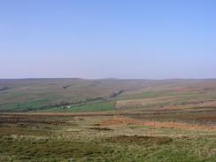
I woke up this morning to be greeted by sunshine, always a nice sight when you are wild camping; there is nothing like unzipping your tent and seeing moorland and a nice warming sun in the sky. It was far too early to set off on the walk, so instead I lay down and read my book for a couple of hours, the suns rays slowly raising the temperature inside the tent to a very comfortable level. Indeed, I could happily have stayed there all day, but there was the small matter of a walk to be done.
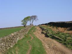
Before I took my tent down I took a good look at the views in the early morning sunshine; all the hills in the local area were clearly visible, including, just, Great Whernside, which I visited yesterday. Eventually I could delay no longer and I took my tent down, packed my rucksack and started heading off across the moorland to the track. This was very stony going on legs that had not yet warmed up, and so I took the initial stretch down In Moor Lane quite slowly, soaking in the view down towards Gouthwaite Reservoir in the distance.
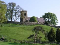
The track eventually ended at a road in the tiny and pretty little village of Middlesmoor, and I was slightly surprised to see that the pub in the village also allows camping - if it had been raining this would have been a much better option than the moorland on which I wild camped. Noting this for the future, I set off along the road, which soon exited the village and headed steeply downhill, passing another caravan and camping site before reaching the village of Lofthouse. This morning I had put some moleskin on the chaffing on my thighs, but after a couple of miles this had come off, and so I sat down on a bench and applied Vaseline to the affected area - never a pleasant job, particularly when done in public.
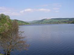
From Lofthouse I had a choice of whether to follow the Nidderdale Way or remain along the road; in the end I chose to follow the road, which fortunately was not too busy as it headed southeastwards alongside the River Nidd to Ramsgill. This was yet another picturesque village, and I had a quick look around before continuing on. The road soon joined the western bank of Gouthwaite Reservoir, which looked simply stunning in the sunlight and I could not resist the temptation to take a few photographs of it. Construction of the reservoir started in 1893 and it was completed in 1901, it is 105 feet high and 70 feet wide at the base. When full it can hold a quite amazing 1,654 million gallons of water, which is probably enough to keep Bradford supplied with water for a long time!
Unfortunately I could not get a good photo of the dam as the land in the area was private, so I headed down along the road, soon reaching a road bridge of the River Nidd at Wath. Here I decided to leave the road and rejoin the Nidderdale Trail, which mainly followed the course of the old Nidd Valley Light Railway (built to help construction of the reservoirs) southwards into Pateley Bridge. This stretch of riverside walking was a pleasant diversion after all the road walking that I had been doing, and I was pleasantly surprised when I reached Pateley Bridge and found the town to be a bustling and attractive place.
It was 11.30, the sun was shining, and I was feeling slightly tired after the mornings walk. I decided to use the opportunity to have a bite to eat, but the local pub, the Rose and Crown, did not open for half an hour, so for the first time on the trip I sat on a bench in the centre of the town sunning myself as I waited. Eventually the pub opened, and I went in to what I thought at first was a slightly dodgy pub - the landlord had tattoos and there were various roguish characters about. Fortunately the friendliness of everyone inside soon dissipated any worries, and I settled down to a ham and cheese toastie and a lovely pint of Black Sheep.
It was tempting to spend the entire day in Pateley Bridge, but I soon realised that I had to move on. I had never been entirely happy with my planned route for the final day to Ilkley, so instead I decided that I would finish the trip in Knaresborough, and so I booked myself into a caravan park nearby for the evening. This meant that I still had over eleven miles still to walk, so with some hesitation I left the pub and set off alongside the river. The initial stretch south of Pateley Bridge was extremely picturesque, and I enjoyed the walk to Glasshouses immensely, although afterwards I started to feel quite tired. The chaffing was getting worse and actually hurting, and I was feeling vaguely dissatisfied and soporific. The few miles to the next village, Summerbridge, seemed to take an age and I found it very hard going, especially when the path left the river and joined the B6165 for the last couple of kilometres.
At Summerbridge the path joined the western bank of the river, which I could follow all the way to Darley where I had to leave the path. Again this was quite picturesque walking, but I really was not in a mood to get the most out of it. I was feeling quite low, and every step seemed to be hard, although I kept pushing myself on until I reached a little footbridge over the river in Darley. I had promised to give myself a rest here, and so when I reached it I took of my rucksack and sat down beside an American couple and their child. They worked at the Menwith Hill military complex on the nearby hillside, and I chatted to them for a while before they departed, probably frightened off by the rather dishevelled character they had been talking to!
Unfortunately the rest did me no good, and I continued to find the road walk uphill extremely difficult. It was not a lack of energy, but the joint effects of the painful chaffing and my left hamstring, which felt quite tight. Eventually I reached the top of the hill and I diverted off to the right for a short distance alongside the fence of the Menwith Hill camp to a trig point in an adjoining field, which I duly photographed and logged. Despite being sorely tempted to take a break I left the field and resumed my walk along he road, heading up to the A59 road that I had to join for a short distance before heading south along another road. Menwith Hill is dominated by the large structures of the American-run NATO listening station, which has become increasingly controversial in the last few years due to its planned use in a missile defence scheme.
And then, just as the end of the stroll came within sight, I started to feel really bad. The last couple of miles along the road were really hard, and I stopped to rest four times, just putting my hands on my knees to relieve the strain on my shoulders, my knees bent to ease my hamstrings. The walk to the caravan site at High Moor Farm seemed to take an age, and even when I reached the entrance I had what seemed like an endless walk to reach the actual campsite. I passed a swimming pool, in which I had absolutely no interest, before booking myself in and hobbling slowly around the site to gain access to my pitch. I took my rucksack off and lay in the sun for ten minutes before putting my tent up. I crawled inside and lay, exhausted, on the groundsheet. I intended to go and have a shower, but when I finally got up after two hours I found that my legs had seized solid, so after ten yards I gave up and walked back to the tent, where I fell thankfully and deeply asleep.
Directions
This walk starts off on the hillside at Rain Stang at grid reference SE082755, where I spent the previous night wild camping. Head across the moorland for a short distance to the southwest to gain access to a rough track called In Moor Lane. Join the track and turn left to follow it as it heads downhill to the southeast, soon entering the enclosed land and joining a road on the northern side of the hamlet of Middlesmoor. Follow the road through and out of the village, as it heads down a small but steep hill before heading southeastwards to cross the River Nidd and enter the village of Lofthouse.
Continue along the road as it heads through Lofthouse and passes out the other side, keeping away from the eastern bank of the river as it heads southeastwards. After a couple of miles it crosses the River Nidd once again and enters the attractive village of Ramsgill. Walk through the village along the road and continue on out of it; fairly soon the road joins the western bank of Gouthwaite Reservoir, which it follows southeastwards. Walk past the dam to the reservoir and then when a road junction is reached on the left, take the new road and follow it as it immediately crosses the River Nidd on a small bridge to head towards Wath.
As soon as the bridge is crossed, turn to the right and take a footpath that heads southwards along the eastern bank of the river. This footpath is part of the Nidderdale Way, which we will be following on and off for most of the rest of the day. Initially the path runs along an old bank, which looks like part of a flood defence scheme but is actually the trackbed of an old narrow-gauge railway line, before descending on the floodplain and entering the northern outskirts of Pateley Bridge. Follow the road through the town into the centre and the attractive bridge over the River Nidd.
Do not cross the bridge but take a footpath that runs south along the eastern bank of the river for a mile into Glasshouses. You can follow a path along the eastern bank of the river from here, but for variety I crossed the road bridge and followed a footpath along the western bank. This passes under the arch of an old railway bridge over the river, before reaching a footbridge over the river. Cross this bridge, and once on the eastern bank turn right and follow a footpath southeastwards until it ends at the B6165 road in Low Laithe.
Turn to the right and follow the B6165 southeastwards for a couple of kilometres towards the village of Summerbridge, before turning to the right and heading downhill along the B6451 road to a bridge over the river. Cross the bridge, and once on the other side turn left to join a footpath that heads southwards along the western bank of the river. The path is easy to follow for the next couple of miles into and through the village of Darley. Once a footbridge is reached on the left turn to the right and climb uphill to the south along a track that leads up to the road in Darley.
Once at the road turn right and follow it for a few yards, before turning to the left along another road. This road heads steeply uphill to the south for a little over a kilometre until a crossroads is reached at the northeastern corner of the Menwith Hill camp. There is a trig point in a field a hundred yards along the road to the right, but the route that I walked continues for a mile straight on alongside the eastern side of the camp.
This road ends at the A59; when it is reached turn left and follow the A59 eastwards for a few hundred yards until a pub is reached, and then turn to the right along another road that heads southwards for a kilometre until it ends at a T-junction by Willow House. At the junction turn left and follow another road eastwards for a little over two kilometres, until the entrance to High Moor Farm campsite is reached on the left. Turn left and follow the driveway northwards through the farmyard to the campsite, where this walk ends.
Distances
| From | To | Distance (m) | Ascent (ft) | Descent (ft) |
|---|---|---|---|---|
| Rain Stang | Pateley Bridge | 8.6 | 545 | 1575 |
| Pateley Bridge | Darley | 6.4 | 472 | 486 |
| Darley | High Moor | 5.2 | 479 | 200 |
This makes a total distance of 20.2 miles, with 1496 feet of ascent and 2261 feet of descent.
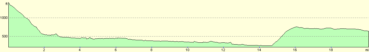
For more information on profiles, ascents and descents, see this page
Accommodation
I spent the night at the High Moor Farm Park campsite, which cost me £7.50 for the night. This was slightly steep as the only facility that I used was the toilet block, but the site itself was quite well kept with clean facilities. There is a heated indoor swimming pool, and a well-stocked shop. The site can be contacted on (01423) 563637.
Disclaimer
Please note that I take no responsibility for anything that may happen when following these directions. If you intend to follow this route, then please use the relevant maps and check the route out before you go out. As always when walking, use common sense and you should be fine.
If you find any information on any of these routes that is inaccurate, or you wish to add anything, then please email me.
All images on this site are © of the author. Any reproduction, retransmissions, or republication of all or part of any document found on this site is expressly prohibited, unless the author has explicitly granted its prior written consent to so reproduce, retransmit, or republish the material. All other rights reserved.
Although this site includes links providing convenient direct access to other Internet sites, I do not endorse, approve, certify or make warranties or representations as to the accuracy of the information on these sites.
And finally, enjoy your walking!
Nearby walks
| # | Title | Walk length (miles) |
|---|---|---|
| 605 | Burnsall Fell to Rain Stang | 19.1 |
|
|

|