Walk #922: Great Glen Way: Laggan to Invermoriston
 |
 |
|
General Data
| Date Walked | 15/09/2011 |
| County | Highlands |
| Start Location | Laggan YHA |
| End Location | Invermoriston car park |
| Start time | 08.00 |
| End time | 16.21 |
| Distance | 20.1 miles |
| Description | This was a pleasant walk following the Great Glen Way northeastwards from Laggan, passing along the eastern bank of Loch Oich to Fort Augustus. After leaving the town it took forestry tracks all the way to the village of Invermoriston. |
| Pack | Today I carried my 30-litre Karrimor rucksack, filled with water, my waterproofs, a book and other odds and ends. |
| Condition | My feet really ached during this walk, perhaps a consequence of the warm, sunny weather and sweating feet (too much detail, I know). Otherwise I felt fine. |
| Weather | Today was a total contrast to yesterday; a warm day with scarcely a cloud in the sky and next to no wind. It soon warmed up after a fairly cold starts. |
| OS map | Landranger number 34 (Fort Augustus, Glen Albyn & Glen Roy) |
 |
 |
|
Map of the walk
Maps courtesy of Google Maps. Route for indicative purposes only, and may have been plotted after the walk. Please let me have comments on what you think of this new format. For a detailed table of timings for this walk, please see the table file.
 |
 |
|
Notes
I awoke early this morning and quickly got changed into my walking clothes so that I could start the long drive to Invermoriston just after six. This took longer than expected due to the dark and a surprising amount of patchy fog. The latter was somewhat welcome because it meant that the fairly persistent drizzle of yesterday was replaced with wall to wall sunshine once the fog lifted. There was plenty of time for me to potter about at the car park in Invermoriston before my bus at twenty past seven, although I nearly got on the wrong bus when two came in quick succession.
The bus dropped me off at the little lay-by where I had finished yesterday's walk, and I was striding off down the trail shortly after eight. Initially the canal remained stubbornly out of view as the path headed high above the water. I crunched along the gravel path through the trees, keen to get a few early miles under my belt.
My legs felt tired after yesterday's long walk and they were taking time to warm up, making me wonder if I had eaten enough yesterday. To make up for this, I scoffed down a packet of nuts and raisins from the emergency reserve that I keep in my pack. Sadly this did not seem to work and the quick pace was not helping matters.
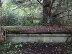
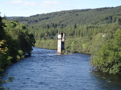
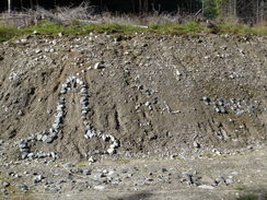
Soon the trail crossed the main road and took a minor road before joining the old railway line to Fort Augustus. Soon I came across a remarkably long platform for what had once only been a quiet branch line. A noticeboard explained this: the company had intended the line to stretch alongside Loch Ness to Inverness, but sadly they ran out of money by the time it reached Fort Augustus. Some large trees were growing out of the platform, although the parts of concrete faces devoid of vegetation seemed to be in a remarkably good state.
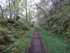
Soon the trail dropped off the old railway line and headed below it, following the course of an old military road. Some works were being done on the old railway line, and a sign later said that there were plans to convert it into a Sustrans cycle path. A little later on the old military road climbed steeply before falling once more, passing the rather ornate portal of a tunnel.
Shortly afterwards I passed a couple of German men who were at the end of a brilliant trip - they had done the Kelvin Way from Glasgow to Milngavie, then the West Highland Way to Fort William, then some other walks in Aberdeenshire, then the Speyside Way and finally this trail. They had certainly enjoyed themselves despite the rather grim weather over the last few weeks, and seemed to be sad to heading home.
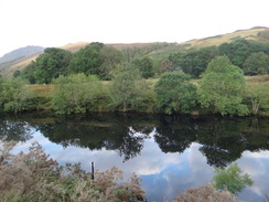
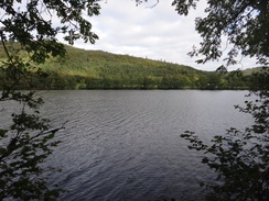
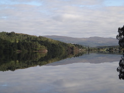
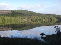
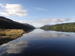
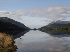
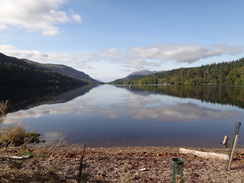
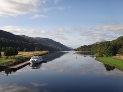
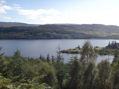
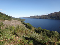
The trail did soon left the military road and crossed a large stream using a long railway bridge. There had been some superb views across Loch Oich on the paths, but the views were now exquisite. Two Scotsmen - the first I had met doing the trail - had camped overnight at what must be one of the best camping spots in this part of Scotland, with the loch stretching away behind them. It was a magic view, and I strolled out onto the water as deep as I dared to take some photos.
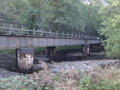
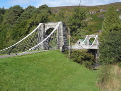
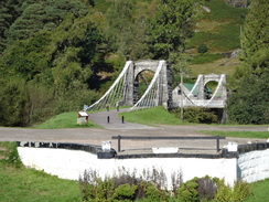
Soon afterwards I got to the Aberchalader Bride that carries the A82 over the canal and the river. What interested me most, however, was the superb Oich bridge. Although this initially looks like a suspension bridge it is actually a double cantilever, each half of the bridge supporting its own weight so that the cables in the middle are far fewer in number than those nearer the towers. I diverted off the trail to study it, took some photos and then rejoined the trail.
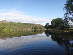
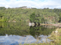
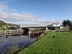
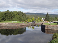
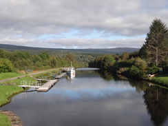
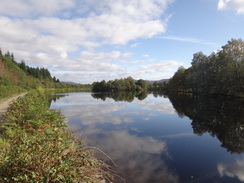
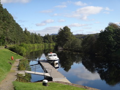
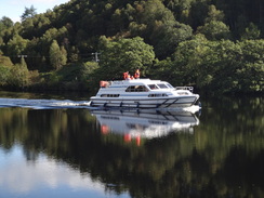
Initially this followed the eastern bank of the canal; off to the right a miniature railway ran for a garden. A yacht motored past me and I turned around to watch as the swing bridge gracefully opened to allow it through. The trail changed over to the western bank at Cullochy Lock, and what followed was a four mile walk into Fort Augustus. It was a fairly uninteresting stroll, with the only items of interest being a few boats that passed and the picturesque Kyltra Lock. The River Oich remained more or less out of view to the left and I soon realised that, whilst the other rivers had flowed towards the west coast at Fort William, the Oich flows into Loch Ness and the east coast. I had crossed the watershed.
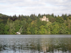
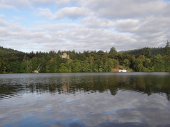
I was in need of a rest by the time I reached Fort Augustus and so I nipped into the Lock Inn to have a break. I ended up having a couple of pints of Belhaven and a wonderful meal of Haggis starter and a beef lasagne main; I really need the food as my energy levels had been remained low all day. The two pints rather went to my head and I set off on looser legs, nipping into the tourist information centre in the town to see it packed with Nessie souvenirs. My low energy levels contributed to a low mood and I felt like stopping here for the day, but I had spent a few nights in the town on previous trips and had fairly well explored the place. Instead I somewhat reluctantly strolled on.
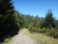
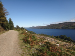
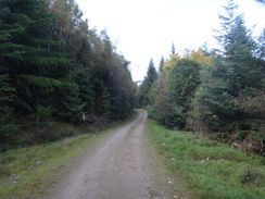
A looping road took me uphill before descending back towards the main road, after which a steep path headed uphill to meet a forestry track. This was followed for well over six miles; there were not too many nasty gradients and the walk was enjoyable enough, with occasional grand views over Loch Ness through clearings in the trees. At other times it was more of a drag and it was a relief when the track started to curve inland along Glen Moriston, as it meant that Invermoriston was just a short distance away. I saw no-one on this stretch of trail, so it felt safe to stop for a pee beside the track. No sooner did I do this than a couple emerged from the trees to the left and strolled on past me. If I ever get into trouble on the hills then stopping for a pee is almost certain to bring someone to my aid...
And then came the words which no walker wants to see - footpath diversion'. A sign stated that due to fallen branches the direct path down to Invermoriston was closed. Unfortunately the indirect diversion would add two miles onto the day. I was not too dismayed by this, but sadly the diversion was along a track that headed down through a gloomy valley that felt like it never saw the sun. It was a fairly dispiriting stroll, and it was a relief when it dropped me out onto a track at the bottom.
This rose and fell slightly, but was a far better stroll than the track through the forest. I soon reached the place where the direct route joined the track and the reason why it had been closed became clear - the path was obliterated by fallen trees. I was thankful that for once I had obeyed the diversion sign instead of continuing on.
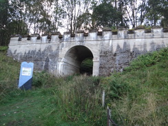
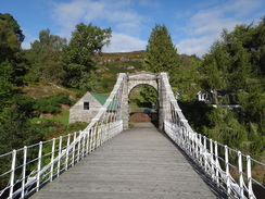
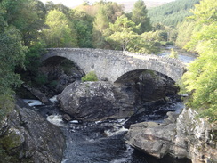
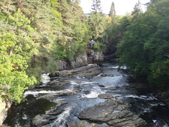
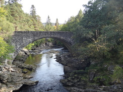
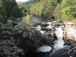
A worthwhile diversion at Invermoriston is to go down to see Telford's old bridge, which seems to spring out of the living rock. The path down to it was a bit rough, but the views along the craggy river were superb. The new bridge (built in 1833) dominates the valley, but Telford's structure seems to be almost part of the living rock, working in harmony with nature rather than overpowering it. The difference between the two bridges, despite that fact that they are both made out of the same stone, shows how bridge-building technology has changed over the years.
My car was only a few yards away and I was soon driving to my night's bed at the Loch Ness Backpackers hostel in Lewiston. I had stayed at the hostel ten years ago and had really enjoyed it, so I was looking forward to a good night. By the time I returned from a walk the hostel room I was in had been invaded by several other Great Glen walkers. They had set off on Monday from Fort William, and had walked from Fort Augustus today. One man had a severely blistered foot; it was so bad that I worry about his ability to do his final day tomorrow.
The hostel has changed a little since I last stayed here in 2002 - it is bigger and now serves food and drink as standard each night. Yet the same friendliness that I saw on my last trip is still present and the staff are very welcoming. These independent hostels are so much better than the authoritarian YHA ones...
 |
 |
|
Directions
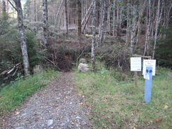
This walk starts off at the bus stop on the A82 near the Laggan hostel at NN294973. Turn right to follow the A82 north for about fifty yards; when the road curves to the right turn left down a track for a short distance until a footbridge over a stream is reached on the right. This is where today's walk rejoins the Great Glen Way. Cross the footbridge and follow a gravel path that leads north through trees for another half mile; it emerges from the trees and the path becomes rough for a short distance until it emerges out onto the A82(T) once more at NN299981, with the Laggan Swing Bridge to the left.
Carefully cross over the A82(T) and turn right to join a private road; this soon curves to the left and passes the entrance to the Great Glen Water Park on the left. The road continues behind the park; as it turns to the left once more, turn right along a track that climbs gently up through trees. The track soon curves to the left, passing a disused railway bridge on the right before joining an old railway line at an old station, the platform of which is covered in trees.
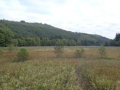
Turn left and follow the old trackbed north-eastwards along the southern bank of Loch Oich. In one or two place rock falls have fallen onto the trackbed and the path climbs these mounds; this was obviously a long-term problem, as large concrete retaining walls protect the line from the hillside in places. After about a mile the path leaves the trackbed at NN314997 to the left, dropping down a short distance to join a path that runs along the course of General Wade's Military Road. This follows the loch's foreshore, with the trackbed in company above and to the right. It soon goes through a gate and continues on.
The path continues on along a sometimes-rough path along the foreshore, with some superb views towards Invergarry over Loch Oich. After a few miles near the northern end of the Loch the path becomes a more recognisable track and climbs steeply away from the foreshore before descending onto the other side of the trackbed; if you look carefully near the summit then you can see a turreted tunnel portal down to the left.
At NH338028 the track reaches a gate; turn left at the gate along a path that parallels a fence for about thirty yards, then climb some steps to reach another gate. Go through this to reach the southern end of a large railway bridge that spans the Calder Burn. Cross the bridge, and immediately on the other side turn left through a tall gate to join a path that leads off to the left; this doubles back on itself, with the burn and river on the left, before curving to the right to parallel the loch's shoreline.
The path then runs around the northern end of Loch Oich. Some superb views unfold from the northern end of the loch before the path turns to head north-northeastward alongside the canal. On the way it passes through another tall gate before heading out onto open grassland, with the canal to the left. After a short distance the path climbs up to a gate that leads onto the A82(T) beside Aberchalder Swing Bridge at Bridge of Oich (NH338035).
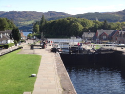
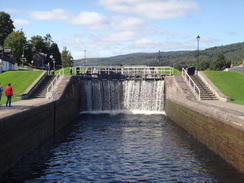
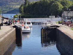
Cross the road at the Aberchalder Bridge and continue on along a track with the canal to the left. This heads north for half a mile before reaching Cullochy Lock at NH341041. Cross the bottom set of lock gates to reach the western side of the canal and then turn right to follow the canal northwards, keeping the canal to the right. It starts to curve to the right, and two miles after Cullochy Lock it reaches Kyltra Lock at NH352067. Continue on past the lock and follow it as it curves to the right and then the left to take a northeasterly course. After 2.2 miles the canal widens and reaches the top of the Fort Augustus locks. Here either side of the canal can be used to descend the short distance down to the swing bridge that carries the A82(T) over the canal in the centre of the town at NH378091.
This leg starts off at the swing bridge on the A82(T) in the centre of Fort Augustus at NH378091. At the bridge turn left to follow the A82(T) as it crosses a bridge over the River Oich and passes the tourist information centre on the left. Shortly after the road curves to the right, turn left up a surfaced path with fences on either side; this soon ends at a road called Bunoich Brae. Turn left along this road as it climbs uphill and swings to the right to descend back towards the A82(T) at NH380100.
The road crosses a small stone bridge over a stream just before it ends at the A82(T); do not cross the bride and instead turn left to follow a path that leads off uphill through woodland with a trickling stream to the right. It crosses a footbridge over the stream and continues steeply uphill until a forest track is met at NH378102.
Turn right and follow the forest track as it heads eastwards, with Loch Ness and the Cherry Island Crannog visible to the right through the trees. After 0.8 miles it descends from the hillside to go through a field gate; on the other side the track becomes surfaced. This heads on to approach the A82(T) on the right. At a track turn left and immediately pass a car park on the right at NH390107.
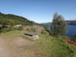
Follow the track as it curves to the right past the car park and immediately crosses a bridge over a stream. The surfacing soon ends as the trail continues uphill along a well waymarked forest track, passing a field gate on the way. It climbs and falls northeastwards along the western bank of Loch Ness for nearly four miles. At NH423152 it joins another track coming in from the right; turn left and join this wide track as it heads uphill. It starts to curves to the left to head away from the loch, with Invermoriston a short distance away down the hill to the right.
Annoyingly the track does not descend immediately but contours around the hill for a mile. At NH413166 a gravel path leaves the track and starts to descend slowly down the hillside (the cycle route continues further inland along the track).
However, the path is sometimes closed due to fallen trees. If this is the case then follow the alternative cycle path that used to carry the trail before the short-cut path was created. Continue along the track as it continues to climb as it heads northwestwards before starting to slowly descend through trees; after a mile it ends at a T-junction with another track at NH401173. Turn right to head down this track; it goes through a deer gate and continues on, becoming a surfaced road.
At NH415167 the main path comes down the hillside from the right to meet the diversionary route along the road. Continue along this road as it heads south-eastwards for 0.7 miles, passing scattered houses on the left to reach the bridge which carries the A82(T) over the River Moriston at NH419165.
Follow the A82(T) as it heads northwards for a short distance until a car park is reached on the right at NH420166, where this walk ends.
 |
 |
|
Distances
| From | To | Distance (m) | Ascent (ft) | Descent (ft) |
|---|---|---|---|---|
| Laggan | Aberchalder | 5.2 | 676 | 595 |
| Aberchalder | Fort Augustus | 5.2 | 56 | 95 |
| Fort Augustus | Invermoriston | 9.7 | 1778 | 1713 |
This makes a total distance of 20.1 miles, with 2510 feet of ascent and 2403 feet of descent.
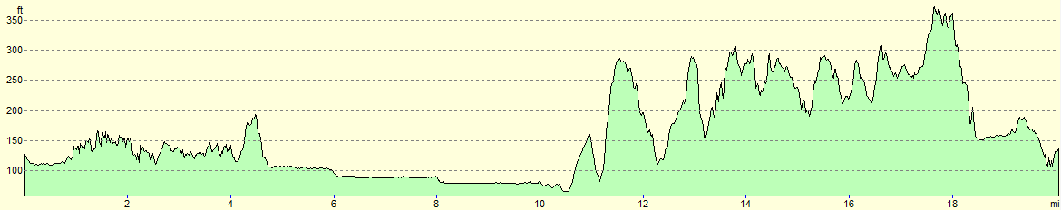
For more information on profiles, ascents and descents, see this page
Accommodation
I spent the night at Loch Ness Backpackers, a rather good hostel at Drumnadrochit beside Loch Ness. This hostel is rather well equipped, and serves meals in the evening in the on-campus bar. The staff are also very friendly. Its cost of £16 per night is more than reasonable, and it is situated just a couple of hundred yards off the Great Glen Way.
Transport
I used the Scottish CityLink service 919 that runs between Inverness and Fort William to get between Invermoriston and Laggan. This service runs every couple of hours during the day, although less frequently during the winter timetable. The bus stop at Laggan is at a lay-by beside a postbox a little north of Laggan Youth Hostel, whilst that at Invermoriston is beside the public car park in the village.
 |
 |
|
 |
 |
|
 |
 |
|
 |
 |
|
 |
 |
|
 |
 |
|
 |
 |
|
 |
 |
|
 |
 |
|
 |
 |
|
 |
 |
|
 |
 |
|
 |
 |
|
 |
 |
|
 |
 |
|
 |
 |
|
 |
 |
|
Disclaimer
Please note that I take no responsibility for anything that may happen when following these directions. If you intend to follow this route, then please use the relevant maps and check the route out before you go out. As always when walking, use common sense and you should be fine.
If you find any information on any of these routes that is inaccurate, or you wish to add anything, then please email me.
All images on this site are © of the author. Any reproduction, retransmissions, or republication of all or part of any document found on this site is expressly prohibited, unless the author has explicitly granted its prior written consent to so reproduce, retransmit, or republish the material. All other rights reserved.
Although this site includes links providing convenient direct access to other Internet sites, I do not endorse, approve, certify or make warranties or representations as to the accuracy of the information on these sites.
And finally, enjoy your walking!
Nearby walks
| # | Title | Walk length (miles) |
|---|---|---|
| 188 | Gairlochy to Laggan | 14.5 |
| 189 | Laggan to Fort Augustus | 10.7 |
| 190 | Fort Augutus to Alltsigh | 11.4 |
|
|

|