Walk #923: Great Glen Way: Invermoriston to Drumnadrochit
 |
 |
|
General Data
| Date Walked | 16/09/2011 |
| County | Highlands |
| Start Location | Invermoriston car park |
| End Location | Drumnadrochit |
| Start time | 07.18 |
| End time | 12.42 |
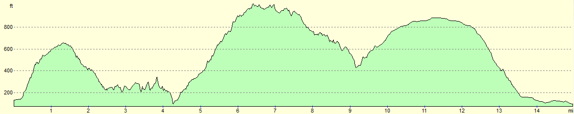
| Distance | 15.0 miles |
| Description | This was a relatively short day, following the Great Glen Way as it heads northeastwards along the northern shore of Loch Ness. Most of the day is spent on firest tracks, with a little road and path walking as well. |
| Pack | Today I carried my 30-litre Karrimor rucksack, filled with water, my waterproofs, a book and other odds and ends. |
| Condition | My feet ached again today, which due to the cooler temperatures cannot be put down to overheating. The other problem to report is that my left foot is hurting where I had problems a couple of weeks ago - I am hoping that it is not a sprain rather than a fracture... |
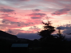
| Weather | A brilliant red sky lit up the morning, which was a bad sign. The sky had clouded over by the time I started the walk, but fortunately the promised rain never materialised. There was a chilly wind which again presages poorly for tomorrow. |
| OS map | Landranger number 34 (Fort Augustus, Glen Albyn & Glen Roy) and Landranger number 26 (Inverness & Loch Ness) |
 |
 |
|
Map of the walk
Maps courtesy of Google Maps. Route for indicative purposes only, and may have been plotted after the walk. Please let me have comments on what you think of this new format. For a detailed table of timings for this walk, please see the table file.
 |
 |
|
Notes
Last night's sleep was sadly interrupted by some French guests at the hostel talking animatedly downstairs at two in the morning; they did not stop even when asked by the owners. This interruption meant that I was very tired by the time that I awoke at half five. I slumbered on for another half hour, then got up and went downstairs to get dressed for the day's walk.
The forecast was for light rain early on and so I was keen to get up and going. A brilliant red sky greeted me as I pulled up in the car park beside the visitors' centre in Drumnadcorchit, and I spent an age getting my kit together; in the end I only had five minutes to get across the road to catch the seven o'clock bus. It was a surprisingly pleasant journey, with Loch Ness gleaming in the sunshine below as the road wound around its edge. The bus dropped me unceremoniously off in Invermoriston and I was slightly surprised to find the small shop in the village open, so I nipped in before heading off along the trail.
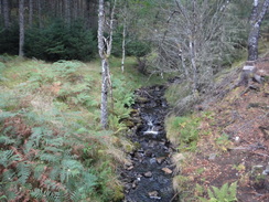
Today's walk promised to have the most ascent of any day on the trail and it started as it meant to go on - a long climb along a minor road that zigzagged into the forest. There were no views to speak of, so I phoned Sencan and her dulcet tones helped me get the miles under my belt. It was quite a climb, and it was a relief when a track took me off to the right, the ascent slightly less steep and far easier to attack. Occasional glimpses of the loch far below enlivened the stroll, and after crossing a stream a long descent started towards the main road and Allt-sigh, where there is a youth hostel.
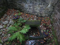
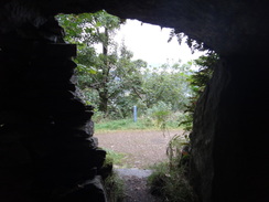
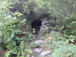
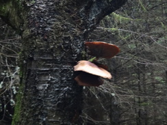
On the way the trail passed a little stone cave built into the hillside, its roof a stone slab. I had sheltered here nine years before and I was unaccountably delighted to see it again and I greeted it as an old friend. I went in and hunched down on the low bench, remembering how the rain had dripped down the entrance on my previous visit. The low roof persuaded me that I would not suit a troglodyte's lifestyle, but the shelter is a wonderfully simple feature.
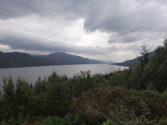
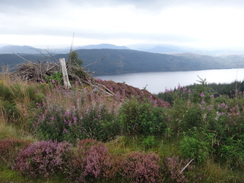
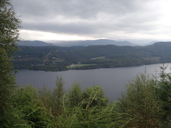
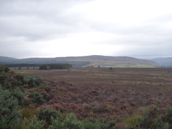
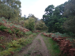
A sign by the stream at Allt-sigh stated that the Glen's last she-wolf was killed at this spot, and the stream's name means the 'Burn of the Bitch'. This was followed by a long climb northeastwards along forestry tracks. The gradient was steep enough for me to attack without stopping and I was soon high up into the forest. Grand views started to emerge through the trees, but it is a shame that my biggest complaint the last time I did this stretch of trail - the scarcity of views over the loch - seems not to have improved over the years.
A couple of zigzags took me higher up the hillside. The increased altitude allowed me to get Radio 5, and tears started rolling down my cheeks as I heard about the miner who has died in the flooded Welsh coal mine. It is silly, but sometimes being out in the wilds causes me to be effected by things much more than usual, and small bits of news of no real consequence weight deeply upon me. I wished the remaining trapped miners well and walked on, feeling slightly angry at the presenter's almost cheery desire for news on the disaster and at my own listening to it. The Chilean mining disaster showed the best of people, but in some ways it showed up the worst of the media - just look at the massive numbers of journalists the BBC sent to cover it.
The top of the second zigzag marked the high point both of the climb and the day, and what followed was a long descent, initially along the track and then along a footpath. I remembered from my previous walk (which had been the week before the trail officially opened) that the stretch where the track turned into path was a steep drop for cyclists, but the area was much less barren now and seemed softer, as if nature had tamed it. Nearby was a relatively flat area of land and the remains of a fire, one of the few places I saw today where wild camping was possible due to the precipitous nature of the trail and hillside.
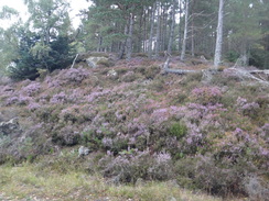
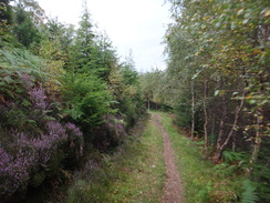
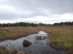
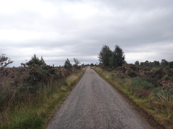
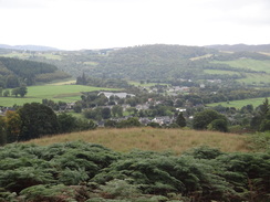
Views vanished once again as the path headed downhill, becoming a track before climbing uphill once more along another path, crossing a stream to reach a road beside a car park at Grotaig. What followed was a long and gentle stroll along the road; the views towards Loch Ness were blocked by the surrounding hillsides. There was little to commend this stretch; even the small patches of surrounding heathland were spoilt by the weather, which was becoming grimmer by the minute. One positive is that there were several stretches of path paralleling the road, although only a couple of cars passed me whilst I was on them.
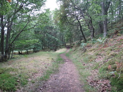
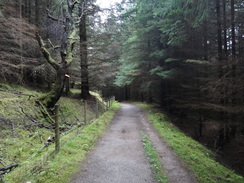
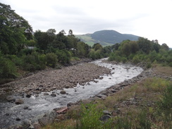
It was a relief when I reached the point where the trail turned left away from the road. This particular piece of woodland was dark and gloomy and the descent seemed to last forever on feet that had become tired. In particular, a little problem I have been having recently with my left foot had come back with a vengeance. The gradient eventually slackened out and a track was joined; this paralleled the Rive Coiltie before reaching the main road on the outskirts of Lewiston.
From there it was simply a case of following the main road back to the car park in Drumnadrochit, where I arrived just five minutes before a heavy shower started. The forecast for tomorrow looks fairly miserable and Sunday is worse; for this reason I may give myself a day off on Sunday so I can visit Inverness and try and work out the best way to do the Speyside Way, the next trail on my list. The day off will also give me extra time to drive to either Buckie or Aviemore, depending on where I want to start that trail. Public transport on the Speyside Way looks terrible; it might have been better to have chosen to backpack it.
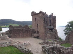
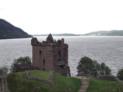
After having had a long shower and generally mucking about, it was still well before three. The threatened rain had not started in earnest and so I decided to visit Urquhart Castle, which I had driven past on many occasions but never visited. There seems to be a mythology around the castle (perhaps due to Sir Walter Scott), but I was less than impressed when I got there. True, it is spectacularly sited on the shores of Loch Ness, but I have been around far more interesting castles in Scotland, yet alone Britain. One thing to note is the lovely stone: the reddish sandstone seemed to glow on the few seconds that the sun deemed to peep out of the clouds. Still, it whiled away a couple of hours as I walked amongst throngs of Chinese visitors, several of whom seemed to mistake me for David Bailey
 |
 |
|
Directions
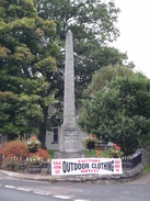
This walk starts off at the car park in Invermoriston at NH420166. Leave the car park and turn right to follow the A82(T) northwards for a short distance until it curves sharply to the right, with a junction with the A887 off to the left. Turn left along the A887 for a few yards, passing the Glenmoriston Arms Hotel on the right, before taking the first road to the right.
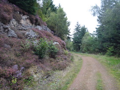
This road climbs steeply and steadily up a series of switchbacks through dark trees. After 0.6 miles the gradient of the road starts to flatten out as it crosses a bridge over a stream at NH420171. Immediately after this turn sharply to the right to join a forest track that re-crosses the stream on another bridge. The track starts to climb as it contours the hillside. Half a mile after leaving the road the track crosses the Allt Coinneag on a bridge; soon afterwards the track forks. Take the right-hand branch which becomes a rough path, and when it forks once more at NH428169 turn right to continue steeply downhill along a path.
This path ends at a wide track, which is followed northeastwards for about 2.4 miles through the trees, passing a stone cave at NH436169 that can be used as a shelter in wet weather. The track slowly descends to reach a bridge that spans the Allt Sigh burn at NH455191.
(if you want Alltsigh youth hostel, then a track leads downhill to the right, passing a white house and ending at the A82(T). The Youth Hostel is a short distance along the road to the right.)
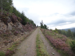
The trail crosses a bridge over the burn before curving sharply to the right and then the left in a long loop. It soon regains a northeasterly direction, and over the course of the next mile it gently climbs; all junctions are well marked with both cycle track and Great Glen Way signs. At NH465201 the track curves around a left-hand hairpin to continue climbing before taking a right-hand hairpin. After another two-thirds of a mile there is a second big set of left- and right-hand hairpins at NH468209, after which the track starts to level off at a height of about 300 metres.
It continues in a north-easterly direction through the forest for a little over a mile until it crosses a bridge over a stream and suddenly ends at NH479222. Here a narrow and rocky path starts a slight descent through Ruskich Wood. It continues for a mile until it meets another track. Turn left to follow the track as it starts heading steeply downhill.
This track starts to descend before rising again, and as it curves to the right at NH494237 a Great Glen Way signpost points off to the left along a path. Take this path as it climbs uphill to a deer gate; go through this and continue along the path through broad-leaved woodland. It soon curves to the right to head down towards a stream, then crosses the stream; shortly afterwards it curves left through a field gate and continues climbing. It parallels a stream on the left to reach a gate. Go through this to reach a surfaced road near the old fort at Grotaig (NH490237).
Join the road and turn right to start following it northeastwards. Along sections of the road a new path has been created that will undoubtedly be easier on the feet than the surfaced road. The first stretch of this path starts shortly after a little car park on the left. This parallels the road, with the road on the right and a fence on the left. The first stretch of path ends and dumps you back out onto the road. At NH501258 a second path leads parallels the road, but this soon ends. The road passes the little house at Woodend and starts to descend.
The trail leaves the road at NH510280, three miles after leaving Grotaig. Turn left through a wooden clapper gate to join a path; follow this as it curves downhill through woodland. It crosses a stream on a footbridge to reach a gate; go through this and follow the path as it curves to the right, becoming a track. It passes a series of bungalows at Clunabeg Lodge on the right before the gradient slackens. It crosses a bridge over a stream, with the bridge over the River Coiltie a short distance away to the left at NH503285.
Do not cross the bridge over the Coiltie, and instead turn right to follow a track east-northeastwards along the southern bank of the river. After 0.6 miles it reaches a road at NH511289. Continue straight on along this road, keeping the river to the left. After a couple of hundred yards the road ends at a T-junction with the A82(T) road, with a small picnic site on the left.
Turn left to follow the A82(T) westwards, immediately crossing the river at Borlum Bridge to reach Lewiston. Continue on as the road gently curves to the right to head northwards into Drumnadrochit; three-quarters of a mile after the bridge the road reaches a car park and visitor centre on the left at NH508298, where this walk ends.
 |
 |
|
Distances
| From | To | Distance (m) | Ascent (ft) | Descent (ft) |
|---|---|---|---|---|
| Invermoriston | Alltsigh | 4.4 | 1250 | 1263 |
| Alltsigh | Grotaig | 5.3 | 1581 | 1073 |
| Grotaig | Drumnadrochit | 5.3 | 331 | 863 |
This makes a total distance of 15.0 miles, with 3162 feet of ascent and 3199 feet of descent.
For more information on profiles, ascents and descents, see this page
Accommodation
I spent the night at Loch Ness Backpackers, a rather good hostel at Drumnadrochit beside Loch Ness. This hostel is rather well equipped, and serves meals in the evening in the on-campus bar. The staff are also very friendly. Its cost of �16 per night is more than reasonable, and it is situated just a couple of hundred yards off the Great Glen Way.
Transport
I used the Scottish CityLink service 919 that runs between Inverness and Fort William to get between Drumnadrochit and Invermoriston. This service runs every couple of hours during the day, although less frequently during the winter timetable. The only feasible stop between the two villages is at Alltsigh youth hostel.
 |
 |
|
 |
 |
|
 |
 |
|
 |
 |
|
 |
 |
|
 |
 |
|
 |
 |
|
 |
 |
|
Disclaimer
Please note that I take no responsibility for anything that may happen when following these directions. If you intend to follow this route, then please use the relevant maps and check the route out before you go out. As always when walking, use common sense and you should be fine.
If you find any information on any of these routes that is inaccurate, or you wish to add anything, then please email me.
All images on this site are © of the author. Any reproduction, retransmissions, or republication of all or part of any document found on this site is expressly prohibited, unless the author has explicitly granted its prior written consent to so reproduce, retransmit, or republish the material. All other rights reserved.
Although this site includes links providing convenient direct access to other Internet sites, I do not endorse, approve, certify or make warranties or representations as to the accuracy of the information on these sites.
And finally, enjoy your walking!
Nearby walks
| # | Title | Walk length (miles) |
|---|---|---|
| 189 | Laggan to Fort Augustus | 10.7 |
| 190 | Fort Augutus to Alltsigh | 11.4 |
| 191 | Alltsigh to Lewiston | 9.5 |
|
|

|