Walk #527: Bettyhill to Melvich
 |
 |
|
General Data
| Date Walked | 14/08/2003 |
| County | Highlands |
| Start Location | Bettyhill |
| End Location | Melvich |
| Start time | 09.04 |
| End time | 17.23 |
| Distance | 21.3 miles |
| Description | This was a lovely walk, mostly along moorland but with a small amount of road walking. |
| Pack | I used my new Highlands water hydration pack, which contained a two-litre water bottle, some spare batteries and a couple of chocolate bars. |
| Condition | A couple of hours before the end of today' walk I started having trouble with my left knee, which started aching. I sprayed some deep heat on it when I reached Mervan for my late lunch, and this seemed to improve matters. Unfortunately on the long road walk afterwards my knee buckled twice, the second time depositing me right on the road. |
| Weather | The rain of yesterday had gone, but the wind was still present. There were some sunny periods but most of the day was cloudy. When the clouds obscured the sun it got surprisingly cold, and the wind certainly did not help matters. |
| OS map | Landranger number 10 (Strathnaver, Bettyhill & Tongue) |
 |
 |
|
 |
 |
|
Map of the walk
Maps courtesy of Google Maps. Route for indicative purposes only, and may have been plotted after the walk. Please let me have comments on what you think of this new format. For a detailed table of timings for this walk, please see the table file.
 |
 |
|
Notes
I was quite tired after yesterday's walk, and unfortunately I woke up quite early. I tried to get back to sleep, but as unusual once I am awake I am awake, and I just could not drop back off. My mind was going ten a dozen, and eventually I gave up and started to read a book. Another couple of hours of sleep would have done wonders, but I guess that it just was not to be.
The rain of yesterday had thankfully gone, but the wind was still gusting quite strongly. As soon as I got up out of bed and out of my duvet I noticed that it was quite cold, and so the fist action was to put the heater on - a very unusual feeling at this time of year. As usual Sam cooked an absolutely marvellous breakfast, and a couple of cups of coffee helped me wake up a little. I was not in a hurry to set off, and I did nothing for a while, which is very unusual for me.
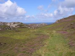
It would have been easy enough to stick to the main road all day today, as it does not run too far from the coast, but from the map it looked as though I may miss some nice scenic areas if I were to do that. There were not many paths over the moorland, and this meant that I had to walk across rough moorland, which was quite enjoyable.
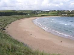
In Armadale I met a nice couple, which I chatted to for about twenty minutes about long distance walking, boots and the Pennine Way. I had considered dropping down to walk across the beach at Armadale Bay, but eventually I decided to walk along to the main road to get around the bay, as it would give my legs a rest from the rough ground - a good decision considering what happened later.
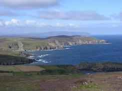
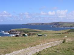
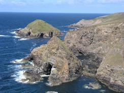
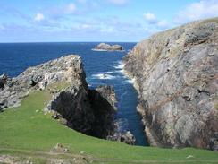
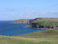
I had told Sam that I would meet her for lunch at the car park near to the Strathy Point lighthouse, which I had been expecting to reach after about four hours. Unfortunately the going was much harder than I had bee expecting, and I eventually reached Sam in Mervan after six hours, a symptom of the rough terrain. I went up to the trig point above Aultivullin, and from there I made my way across some beautiful moorland and cliffs to the lighthouse. This was built in 1958 and is a very modern example, and did not look as good as many of the lighthouses I have seen on the trip. It is painted the same white colour as all the Trinity House lighthouses, but is more akin to a World War II blockhouse than one of the classic round tower lighthouses. This was made up for by the views along the coast - I could see west toward Durness, and east to Dunnet Head, with the dome of the Dounreay nuclear plant clearly visible. It was an absolutely breathtaking view, and I stopped for a few minutes so I could soak the view in.
On this last section of moorland to the lighthouse I started to get a little pain in my left knee, and as I continued on it got increasingly worse. Once I reached Mervan I sprayed deep heat on it, and it seemed to ease the discomfort. I decided to walk to Melvich along the road instead of the cliffs to try to reduce the strain on my knee, but unfortunately after about a mile it buckled mid-step when I put weight on it. I managed to catch myself without falling, but it happened again about half a mile later and I fell sideways onto the road, to the obvious alarm of some Italian motorcyclists coming in the opposite direction, who seemed to think that I was drunk. I picked myself up and brushed myself down, and took the last mile or so at a slower pace to reduce the strain on my knee. Fortunately it did not give way again, but it aches a lot and I am more than a little concerned about it.
The nights are definitely closing in now, and as we sat in Mervan tonight watching the Bill I was surprised to see the streetlights coming on at 20.35. This was surprising for two reasons; not only because of the time, but also because it was the first time in ages we have spent the night near streetlights! It is a really strange feeling to actually go to bed in the dark, and it is hard to imagine how I coped with the early evenings when I was walking in winter.
Directions
This walk starts off at the car park in Bettyhill, opposite the hotel in the village. Leave the car park and turn left to head downhill past a campsite and a little church (now a museum) on the left. Just after this a pub is passed on the left; continue on and take a driveway off to the left that leads towards the pub. When the driveway curves to the left after a few yards continue straight on along a path that heads northwards, passing Clerkhill before eventually ending by a farm at the end of a road in Farr. Turn right and head southeastwards down the road through Farr, and when a road junction is met on the left turn left and follow the road in a rough easterly direction. Just before the road ends turn right down a track that descends into a valley before ending at a farm. A very rough grassy track leads on southeastwards from the farm to a little decrepit footbridge over the Swordly Burn, where it turns to head eastwards for about a hundred yards up to a road.
Turn slightly right to head eastwards up the road for a few yards, and when it curves to the right take a path to the left that heads eastwards uphill, passing a small cairn before descending down to meet a road. Turn left to head northwards through Kirtomy, and then just after a phone box take a road off to the right that dips down to a bridge over Kirtomy Burn. The road then rises up and curves to the left and after a few yards a track leads off to the right between houses. Follow this track as it rises up the hillside to the northeast, and when it ends continue northeastwards down into a little valley and up the other side towards Lochan Tiormachd. Walk around the eastern side of the lochan and continue on northeastwards past a little loch until a vague track is reached. Turn right along this track and follow it southeastwards.
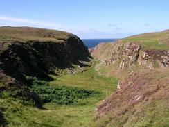
The track skirts around a ruined building before continuing on before ending at a road in Armadale. turn right and had south for a mile along the road until it ends at a junction with the A836 road. Turn left and follow the A836 road eastwards for over a mile as it crosses the Allt Beag and the Armadale Burn before climbing uphill. At the first road junction on the left turn left and follow the road northward for about a kilometre towards Fleuchary. When the road curves sharply to the left to head towards the farm turn right along a shallow valley to head northeastwards towards a farm at Aultiphurst. From here I followed the edge of the cliffs northeastwards towards Aultivullin, immediately before which there is a very steep and deep valley that I had to walk around
After Aultivullin I climbed up to the trig point at the top of Druim Allt a' Mhuilinn, and then followed the cliffs around towards Strathy Point. Eventually I met the access road to the lighthouse and followed that northward to the lighthouse. Once there turn around and walk south for a little over two miles until the road ends at a T-junction with the A836 road. Turn left and head eastwards for a little over three miles until the Melvich Hotel is reached on the left, where this walk ends.
Distances
| From | To | Distance (m) | Ascent (ft) | Descent (ft) |
|---|---|---|---|---|
| Bettyhill | Armadale | 8.6 | 1568 | 1604 |
| Armadale | Strathy Point lighthouse | 6.5 | 873 | 948 |
| Strathy Point lighthouse | Melvich Hotel | 6.2 | 630 | 509 |
This makes a total distance of 21.3 miles, with 3071 feet of ascent and 3061 feet of descent.
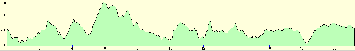
For more information on profiles, ascents and descents, see this page
Accommodation
We spent the night in a little car park opposite the Melvich Hotel in Melvich, which was naturally very handy for the bar in the hotel. There were also some public toilets in the car park, which was useful.
Disclaimer
Please note that I take no responsibility for anything that may happen when following these directions. If you intend to follow this route, then please use the relevant maps and check the route out before you go out. As always when walking, use common sense and you should be fine.
If you find any information on any of these routes that is inaccurate, or you wish to add anything, then please email me.
All images on this site are © of the author. Any reproduction, retransmissions, or republication of all or part of any document found on this site is expressly prohibited, unless the author has explicitly granted its prior written consent to so reproduce, retransmit, or republish the material. All other rights reserved.
Although this site includes links providing convenient direct access to other Internet sites, I do not endorse, approve, certify or make warranties or representations as to the accuracy of the information on these sites.
And finally, enjoy your walking!
This walk was mentioned in the following routes:
| My walk around the coastline of Britain |
| My sectional Land's End to John O'Groats walk |
Nearby walks
| # | Title | Walk length (miles) |
|---|---|---|
| 526 | Hope to Bettyhill | 23.5 |
|
|

|