Walk #761: Pandy to Hay-on-Wye
 |
 |
|
General Data
| Date Walked | 02/04/2007 |
| County | Gwent, Herefordshire, Powys |
| Start Location | Pandy |
| End Location | Hay-on-Wye |
| Start time | 07.30 |
| End time | 15.23 |
| Distance | 16.4 miles |
| Description | This was an exceedingly pleasant walk following Offa's Dyke as it heads northwards over the Black Mountains |
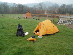
| Pack | Today I carried my 80-litre Macpac Glissade rucksack, containing a North Face Blue Kazoo sleeping bag, my North Face Westwind tent, clothes, waterproofs and other camping items, including cooking gear. |
| Condition | The blisters on my little toes gave me slightly more gip today, and my left shoulder gave me a little pain at times; I am obviously not fully used to carrying this pack yet. |
| Weather | The day started off cloudy and hazy, but as the day went on the cloud cleared leaving behind a sunny, pleasant day. For the third day in a row there was a very stiff, chilly breeze. |
| OS map | Landranger number 161 (Abergavenny & The Black Mountains) |
 |
 |
|
 |
 |
|
Map of the walk
Maps courtesy of Google Maps. Route for indicative purposes only, and may have been plotted after the walk. Please let me have comments on what you think of this new format. For a detailed table of timings for this walk, please see the table file.
 |
 |
|
Notes
I had a reasonable night's sleep last night, although when I woke up a couple of times the wind was still gusting around the tent. I was fairly nervous about the stiff walk ahead, and I packed up my tent quickly without bothering to stop to cook any breakfast. The meal last night had been very filling, and I was not very hungry at all. As there had been wind last night there was no condensation on the inside of the tent, and this meant that I was not bothered about waiting for the tent to dry before heading off at about seven thirty to rejoin Offa's Dyke path a few yards away opposite the now-closed pub.
A footpath led across a field and a pretty stream before climbing up some steps to cross the Hereford to Newport railway line in the company of a couple of dog walkers. A short stretch of footpath led to another road, and the way left this for a short distance to climb up a field that felt surprisingly steep on stiff, cold legs. This was also where I first noticed the strength of the wind for the first time, and I put my hat on to make myself feel warmer as the gradient of the road steepened. It felt good to be gaining height considering there was a lot of climbing to be done, and it was therefore a little annoying when the road curved around to the right and started steeply dropping down back towards the valley floor.
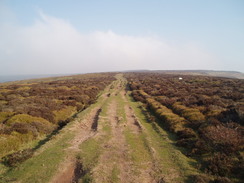
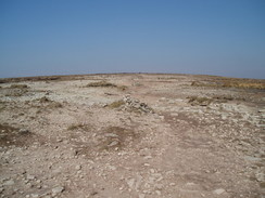
Fortunately the path left the road before it had dropped too much, and started heading steeply up a rough green lane for a short distance before entering open moorland, with a few trees scattered about. The climb was very steep up to the assorted bumps and ditches of the Pentwyn iron-age fort, although once the fort was reached the gradient thankfully slackened a little and I could rest my legs a little. I had been hoping for a good day today, but unfortunately the clouds were low above my head blocking out the sun and the stiff, chilly breeze seemed to be stronger now that I was fully exposed to it. Beside the path at the fort there was a solitary boot sitting alone on top of a rock, and as usual when I occasionally see these scattered around the countryside I wondered how on earth they get there - does someone head downhill with only one boot, or has it dropped off someone's pack?
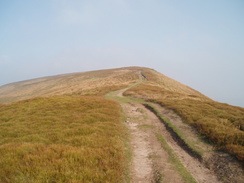
The gradient had noticeably slackened and indeed dropped a little before starting to climb up towards a low stone wall enclosure called The Castle. Here the gradient increased, and I took my time on the climb up to the first trig pillar of the day to the south of Hatterrall Hill. A gentle climb followed along a good path that led up the long crest of the hill as the sun came out momentarilly and it was an easy walk, although the distant clouds did block out the views and make it less enjoyable than I would have liked, although the clouds were starting to slowly lift.
At the start of the next climb I got a few views down the Honddu Valley towards the fabulous ruins of Llanthony Priory, somewhere I have memories of pony trekking and other things from when I was a child, strange memories that I had been expecting to depress me but instead seemed to spur me on. The views were limited by the clouds, and as I climbed the flank of the wide ridge prevented me from seeing it again as I climbed up to another trig pillar.
I decided not to stop here as I had been planning due to the wind, and instead continued up along the gently-ascending ridge. The path was exceptionally easy to follow as it climbed, and the sun was starting to come out through the clouds overhead, making me feel much better. There were also more walkers about on the trail, whereas earlier in the day I had not seen anyone aside from a couple of dog walkers in the valley - a surprise given the time of year.
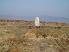
It was an easy walk to the next trig pillar - the climb up to the 610-metre point being gradual - and I decided to stop off for a break. The wind was fairly fierce and so I put my rucksack down onto the plinth of the pillar and sat down on the lee side, using the concrete of the pillar and my rucksack to protect me as much as possible from the wind. There were not any particularly good views to be had from where I sat, but it was nice to have the weight off my feet and I wolfed down the last of my flapjack as I huddled away from the wind. In the concrete plinth at the bottom of the pillar were some illegible names and a date, 1954. The silence was shattered by the sight of a Harrier flying overhead, another soon followed it, a little further away from me.
Once I set off again I soon warmed up as the path continued to climb, and the lifting clouds also helped to lift my spirits as I could see the surrounding hills well and clearly for the first time in the day. To my right the spur hill of Black Hill was visible, and as I approached the highest point of the Black Mountain the terrain became more moon-like and rough. A couple of groups of Duke of Edinburgh Award children came past me as I walked, and I occasionally gave them words of encouragement as they passed.
It was hard to tell exactly where the summit was on the stone causey that crossed what could be a boggy area in wet weather, and so I just pressed on as the path turned northwestwards and steeply descended some steps down a little bluff. At the bottom of this there was a signpost that marked a junction in the paths; the official path headed down to the right to slowly descend down the side of the hill, but there was an alternative route on the map that led up a alight rise to the trig pillar at Hay Bluff.
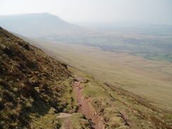
As the views from Hay Bluff were supposed to be spectacular I took that route, and flagstones underfoot helped me reach the trig pillar quickly. The views were stunning despite a slight haze, and I stood around looking down towards Hay-on-Wye in the distance as the wind whistled around me, although the haze did spoil the views somewhat.
The path down the side of the bluff was not immediately obvious, and the descent over the edge looked precipitous and impossible to walk. After a couple of minutes I found the start of the path, and it proved easy enough to descend as it contoured along the side of the hill, even with the weight of the pack on my shoulders. The path zig-zagged down the hill, a steep and sometimes rocky descent that continued to be relatively easy. I could not help but look back up the slope towards the top of the bluff, and I could see people in the distance starting their descents down the hill.
At the bottom of the bluff the gradient slackened and a wide path led on to a car park beside a little road. The vast majority of the climb for the day had been done, and so as a form of celebration I stopped off at the ice cream van that was sat in the small but busy car park and bought myself an ice cream. As I ate this I could literally feel my body cool down, and I quickly scoffed it as I headed on down the road, passing a stone circle on the way.
The hard surface of the road hurt the underside of my feet and this slowed me down even as the road slowly descended, passing the point where the route over Hay Bluff rejoined the official route and then headed off northwards along a pleasant field. When this descended down into a little valley that was sheltered from the wind I decided to stop for a short break, shrugging my rucksack off onto a stone and sitting down on another one. My feet were aching alot, and I took my boots off and gave the undersides a little massage to try and relieve them a little.
Once I set off again the path climbed out of the little valley before continuing along across some smooth grass on some common land. This eventually joined a little track that headed downhill, initially with a stream running down the track before the path headed off to the right and above of the stream. The path left the environs of the track and started to descend down a field, and ahead I could see a long red line snaking through the landscape in the distance, which I assumed was the works for the gas pipeline that is being constructed across Wales. I ended up crossing the works soon after as the path descended, and although a haul road had been constructed the works were still preliminary, with ripped-out hedges being shredded.
Immediately after this the path met a road to cross a stream, and after this there was a footpath diversion that was not marked on the map, which seemed to be an official diversion of the trail (the guidebook stated that a diversion was planned, and it had obviously been opened). This headed around the edges of a field, before rejoining the original route as it descended into some woodland. The rest of the walk into Hay-on-Wye was easy enough going, although with my feet aching it was not as pleasant as it could have been.
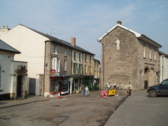
The centre of the town was absolutely bustling, and I stopped at a corner to stop my GPS before heading off to find Belmont B&B that I had booked myself into, which turned out to be close by. The lady let me into a room in the annexe of the B&B and I unpacked my rucksack before going to the adjacent bathroom for - luxury of luxuries - a bath! Once I was clean I created a shopping list and went out, initially visiting a chemists before reveling as I visited some of the bookshops in the town - a true bibliophiles paradise, and somewhere that I will have to take Sencan sometime. It was tempting to buy a book or two, but I had to resist as I really did not want to have to carry them up and down the hills over the next few days.
Once the bookshops started to close I headed back to the B&B for a while before heading out to at the Blue Boar, a nearby pub. I ordered a steak meal, but I was halfway through eating it when suddenly the lights in the area that I was sitting went out, leaving me only scant illumination by a light on the other side of the room. I asked the barman if the lights could be put on, but he gave the ridiculous claim that he had been told to turn half the lights in the pub off at seven in the evening to save electricity, and he refused to turn them back on whilst I was eating. This is absolutely terrible customer service, and I was staggered by the indifference he showed and so I quickly finished the meal and left. It was certainly not a nice end to a rewarding day's walk. One thing of note is that today is the first day of the smoking ban in Wales, and I was looking forward to be able to visit some smoke-free pubs during the rest of the trip.
Directions
| The walk is covered in detail in the Offa's Dyke National Trail Guide South (Chepstow to Knighton), by Ernie and Kathy Kay, and Mark Richards, ISBN 1-84513-274-2 published by Aurum Press Ltd. Click on the image to the right to go to the Amazon page for the book. | 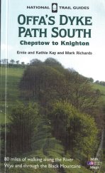 |
Distances
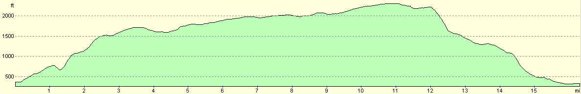
| From | To | Distance (m) | Ascent (ft) | Descent (ft) |
|---|---|---|---|---|
| Pandy | Hatterrall Hill | 3.8 | 1529 | 200 |
| Hatterrall Hill | Hay Bluff | 8.2 | 997 | 472 |
| Hay Bluff | Hay-on-Wye | 4.4 | 85 | 1972 |
This makes a total distance of 16.4 miles, with 2611 feet of ascent and 2644 feet of descent.
For more information on profiles, ascents and descents, see this page
Accommodation
I spent the night at Belmont House, Hay-on-Wye, Herefordshire HR3 5DA. They can be contacted on (01497) 820718 or on the web at http://www.hay.co.uk/belmont/welcome
Disclaimer
Please note that I take no responsibility for anything that may happen when following these directions. If you intend to follow this route, then please use the relevant maps and check the route out before you go out. As always when walking, use common sense and you should be fine.
If you find any information on any of these routes that is inaccurate, or you wish to add anything, then please email me.
All images on this site are © of the author. Any reproduction, retransmissions, or republication of all or part of any document found on this site is expressly prohibited, unless the author has explicitly granted its prior written consent to so reproduce, retransmit, or republish the material. All other rights reserved.
Although this site includes links providing convenient direct access to other Internet sites, I do not endorse, approve, certify or make warranties or representations as to the accuracy of the information on these sites.
And finally, enjoy your walking!
This walk was mentioned in the following routes:
| Offa's Dyke |
Nearby walks
| # | Title | Walk length (miles) |
|---|---|---|
| 760 | Monmouth to Pandy | 16.4 |
|
|

|