Walk #760: Monmouth to Pandy
 |
 |
|
General Data
| Date Walked | 01/04/2007 |
| County | Gwent |
| Start Location | Monmouth |
| End Location | Pandy |
| Start time | 08.58 |
| End time | 16.38 |
| Distance | 16.4 miles |
| Description | This was a pleasant walk following Offa's Dyke path as it heads across rolling farmland, passing the superb ruins of White Castle on the way. |
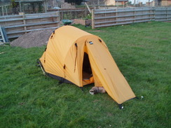
| Pack | Today I carried my 80-litre Macpac Glissade rucksack, containing a North Face Blue Kazoo sleeping bag, my North Face Westwind tent, clothes, waterproofs and other camping items, including cooking gear. |
| Condition | I feel much better than I did after yesterday's walk, and have had no significant problems. I have a couple of small blisters on my little toes in the ususal manner, but these are not troublesome. |
| Weather | The day was mostly sunny with few clouds in the sky, |
| OS map | Landranger number 162 (Gloucester & Forest of Dean) and Landranger number 161 (Abergavenny & The Black Mountains) |
 |
 |
|
 |
 |
|
Map of the walk
Maps courtesy of Google Maps. Route for indicative purposes only, and may have been plotted after the walk. Please let me have comments on what you think of this new format. For a detailed table of timings for this walk, please see the table file.
 |
 |
|
Notes
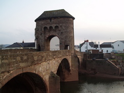
Despite the travails of last night I had a reasonably long and pleasant sleep despite the rustling of some nearby bin bags and the cold, a sign of exactly how much yesterday's walk had taken out of me. I awoke at around seven, and as the day's walk was going to be shorter I decided to go for a short walk into Monmouth, as I doubted that there would be much to do at the other end of the walk in Pandy. The town had been bustling when I had walked through it the night before, but this morning it was essentially deserted, and I crossed the ancient Monmow Bridge to reach a newsagents, one of the few shops that was open, to buy myself a packet of crisps and a bottle of Ribena.
It took me rather a long time to get my tent down as a man started talking to me about my tent, and he stated that he had fought in the Falklands War. This was possible but something did not seem quite right about his story. Despite the interruption I headed off just before my target time of nine, and started off along the road that led northwestwards out of Monmouth. This was soon left as the trail headed off down Watery Lane, with a stream initially on the left-hand side of the road and later on the right. I was feeling rather confident at the start of the walk, and I had decided not to wear my knee braces for the day. I had a shorter distance to do over what looked like easier terrain, and two extra hours in which to do it.
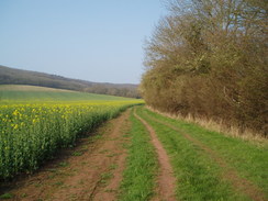
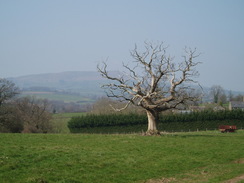
Monmouth had seemed like a pleasant place and somewhere that I would like to visit again. Wsatery Lane eventually ended near some new housing that was not marked on my map,and a muddy lane took me on, the first real mud that I had seen on the whole trip. After such an exhausting day yesterday I decided to take it easier today, and as the path headed steeply uphill through Whitehall Wood I took my time, ensuring that I did not loose by breath. There was not a cloud in the sky although I was still wearing my coat to protect me from the brisk wind.
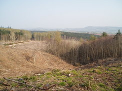
At the top of the hill there was a clearing where the trees had been felled, and this had revealed some good views back over the hills the way that I had come, after which a forestry track was joined, which was hard on my feet. The path descended down to meet a road at Lower Hendre and then Hendre Farm, where there was a B&B, a converted barn with long vertical slit windows and a bunkhouse, which could make it a good place to stop for the night. The path descended down towards a floodplain and headed past the site of the old Grace-Dieu Abbey, of which nothing remains above the ground. Underfoot the ground was rough having been churned up by cattle, and although it was dry it was hard to walk over, and I took my time in order not to twist my ankle. After crossing the River Trothy. Footpaths headed on towards Llanvihangel-Ystern-Llewern, where the church (the magnificently-named St Michael's of the Fiery Meteor) glinted in the sunshine.
A pleasant climb followed along a footpath up Marl Hill, and my feet started to ache increasingly when the trail joined a road for a short distance, before heading off across fields once more towards Penrhos Farm. A long road walk followed towards the village of Llantilio Crossenny, the halfway point of the day, and I had been looking forward to stopping off at the pub that was marked on the map, which had a good write-up in the guide book. Unfortunately when I reached the village this proved to be closed, and so instead of taking a break at this halfway point I decided to walk on towards White Castle, which seemed like a better place for a break than the middle of a field.
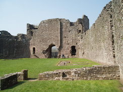
The path led across fields towards Treadam, where signs seemed to denote that there might be some form of hostelry, although I was not going to divert off to investigate. A long track enclosed by hedges led up a gradual hill that, despite the relatively slight gradient, and the underside of my feet were starting to ache. It was therefore a relief when the track reached a surfaced road and, a few yards later, the fairly spectacular white walls of the castle became available.
There was a tiny shop, and after chatting to the lady inside I bought a ticket for �2.50 and entered the castle. The outer ward was reached via a bridge over a deep ditch, and as the wind was still blowing coldly around the low walls I continued over another spectacular ditch to reach the inner ward. There were some handy benches arrayed around the inside of the walls, and after finding one that seemed to be more or less sheltered from the wind I gratefully shrugged my rucksack off and sat down to eat a spot of lunch. The target="_blank">castle was built in the Twelfth Century along with two other nearby castles, and was substantially rebuilt in stone later on, getting it's name from the white plaster that was used on the walls.
It was really a magnificent spot, and I took my boots off for a few minutes to allow them to cool down and give them a massage. Even in the slightly sheltered spot the wind was still gusting around my position occasionally, and so after a while I put my boots back on and started to walk around, examining the few information boards and looking out over the deep ditch. The highlight - literally - was the climb up about three stories into one of the towers, from where some expansive if breezy views were available, although the steep stairs and boots were awkward to climb in my large walking boots.
After a while I headed back down as the wind had got to me a little, put my rucksack on once more and headed off. I chatted to the lady for another couple of minutes about the walk, and I realised how much I was missing talking to people on this walk, something that often occurs to me when I am on a backpacking trip. As the path descended down towards a farm there were some good view back towards the curtain walls of the castle that I had to look back and view occasionally. These views soon disappeared as the path turned off and headed downhills across fields, crossing the River Trothy before reaching the B4521.
By now I was running out of water, and so when I saw a man gardening outside his house I asked him if he could fill it up, and after I got the water I took a few pleasant cool mouthfuls before starting another small ascent up a footpath. The gradient slackened and the path descended to cross a stream before reaching a road. This was followed northwards for a short distance before descending to cross the Full Brook, where I stopped to chat for a minute to another group of walkers.
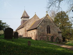
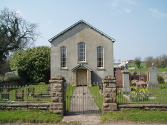
A steep climb followed uphill to the glorious whitewashed church at Llangattock Lingoed, and as I entered the churchyard a couple asked me about the correct route downhill. We ended up chatting for a long time; they were doing Offa's Dyke in a series of day walks out-and-back, and told me that the stretch that I would be doing over the Black Mountains tomorrow would be superb. It was once again a nice chat, and after I set off I was faced with a series of footpaths that fell before rising to a summit near a road from where there were some great views over the hills to the north. Fortunately this climb was followed by a gentle descent downhill across fields, and as I neared the A465 road I was concerned by a loose dog in a field that appeared to be worrying some sheep, but there was little that I could do except tell the first people I saw at a house near the road.
The place that I was staying was fairly easy to find opposite the Lancaster Arms pub beside the road, and after I knocked on the door I was surprised to find it answered by a man in a wheelchair. We had a quick chat and he told me where to put my tent up, and I took my time over the task as I basked in the afternoon sunshine as a man worked away in an adjacent allotment and a boy played games in the field. It was a pleasant spot, but I soon got hungry and decided to go for something to eat. Before I could do this I wanted to have a shower, and the owner allowed me to have a shower in his wet room, after which I paid him for the night and headed back to the tent, feeling much better after the shower.
Unfortunately the Lancaster Arms on the other side of the road had been closed since late last year (there are several pubs and hotels within a couple of miles along the road) and so I was faced with a walk along the road, which fortunately had a wide verge alongside it. I ignored the first hotel on the right as I was unsure if they would be serving food, and instead headed on for another hundred yards to the Old Pandy Inn. I went inside and was made to instantly feel welcome, and I had a lovely lasagna and chips washed down with a couple of pints as I read a couple of shooting magazines that were on the side in the pub. As I ate a group of Duke of Edinburgh Award girls from Stretham in South London came in, and their overheard jovial banter made me feel very good for some reason.
As I walked back there was a lovely red glow as the sun sunk down between a gap in the hills, and this combined with the couple of pints put me into somewhat of a euphoric mood. Tomorrow I have got what should be a stunning walk ahead of me, and one that I have been supposing is a highlight of the entire trip. If the fairly fierce winds of today continue tomorrow then it will not be too enjoyable, however.
Directions
| The walk is covered in detail in the Offa's Dyke National Trail Guide South (Chepstow to Knighton), by Ernie and Kathy Kay, and Mark Richards, ISBN 1-84513-274-2 published by Aurum Press Ltd. Click on the image to the right to go to the Amazon page for the book. | 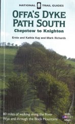 |
Distances
| From | To | Distance (m) | Ascent (ft) | Descent (ft) |
|---|---|---|---|---|
| Monmouth | Llanvihangel-Ystern-Llewern | 5.5 | 541 | 449 |
| Llanvihangel-Ystern-Llewern | White Castle | 5.2 | 778 | 404 |
| White Castle | Pandy | 5.7 | 801 | 955 |
This makes a total distance of 16.4 miles, with 2120 feet of ascent and 1808 feet of descent.
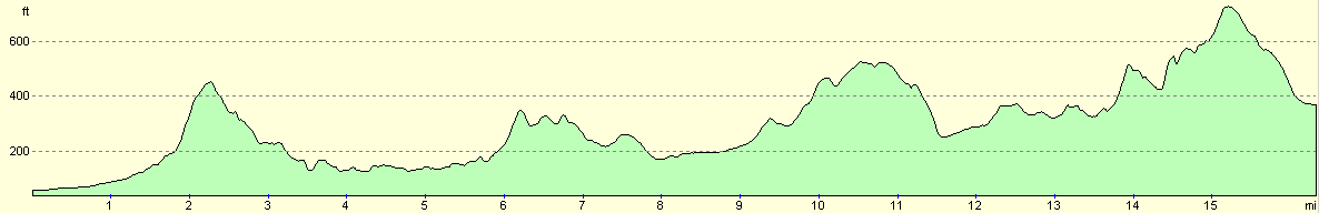
For more information on profiles, ascents and descents, see this page
Accommodation
I spent the night at Lower Treveddw, PANDY, Abergavenny, Monmouthshire. Telephone: (01873) 890678. This was a cheap site with not many facilities, but it did the jon.
Disclaimer
Please note that I take no responsibility for anything that may happen when following these directions. If you intend to follow this route, then please use the relevant maps and check the route out before you go out. As always when walking, use common sense and you should be fine.
If you find any information on any of these routes that is inaccurate, or you wish to add anything, then please email me.
All images on this site are © of the author. Any reproduction, retransmissions, or republication of all or part of any document found on this site is expressly prohibited, unless the author has explicitly granted its prior written consent to so reproduce, retransmit, or republish the material. All other rights reserved.
Although this site includes links providing convenient direct access to other Internet sites, I do not endorse, approve, certify or make warranties or representations as to the accuracy of the information on these sites.
And finally, enjoy your walking!
This walk was mentioned in the following routes:
| Offa's Dyke |
Nearby walks
| # | Title | Walk length (miles) |
|---|---|---|
| 759 | Sedbury Cliffs to Monmouth | 20.0 |
|
|

|