Walk #680: Strood to Hollingbourne
 |
 |
|
General Data
| Date Walked | 02/07/2005 |
| County | Kent |
| Start Location | Strood station |
| End Location | Hollingbourne station |
| Start time | 08.39 |
| End time | 16.51 |
| Distance | 21.8 miles |
| Description | This was a nice walk along the North Downs Way, with some good views available over the plains to the south. |
| Pack | Today I carried my 30-litre Karrimor Hotrock rucksack, containing only waterproofs and a few odds and ends, such as spare batteries. |
| Condition | The biggest problem that I have suffered today is chaffing, which despite the liberal use of Vaseline has been very bad. Aside from this the underside of my feet ached, but this was not a major problem. |
| Weather | Today was much cooler than the last weekend that I went walking, and I was very glad about this. It was a cloud day with few, if any, glimpses of the sun, and it was also quite warm and muggy. There was a nice breeze that helped me to keep cool, and it was a very comfortable day for walking. Early on there was a few minutes drizzle, but this was the only rain that I saw all day, despite some ominous grey clouds. |
| OS map | Landranger number 178 (Thames Estuary, Rochester & Southend-on-Sea) and Landranger number 188 (Maidstone & The Weald, Royal Tunbridge Wells) |
 |
 |
|
 |
 |
|
Map of the walk
Maps courtesy of Google Maps. Route for indicative purposes only, and may have been plotted after the walk. Please let me have comments on what you think of this new format. For a detailed table of timings for this walk, please see the table file.
 |
 |
|
Notes
It had originally been intended for this walk to be done as part of a two-day walk along the North Downs Way to Wye, but a lack of suitable accommodation in Hollingbourne caused me to change my plans, and I decided to only do the one day this weekend. I had a good journey down to Kent, and I parked my car in virtually the same spot in the car park at Strood where I had parked it a fortnight before. I bought a ticket for the day, shouldered my rucksack, and headed off down the road.
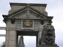
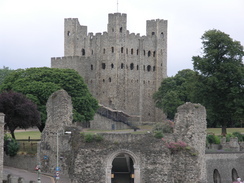
My initial aim was to reach the western edge of the Medway Bridge, where I had left the North Downs Way a fortnight before. The walk that I had done previously had been along roads on the western side of the Medway, and it had been a uniformly boring walk. For this reason I had decided to walk along the eastern side of the river today, where it looked as though there would be far better views. My first steps therefore took me across Rochester Bridge, a structure that is far more elegant close up that it is from a distance. There are some nice touches, including statues of recumbent lions and brightly-painted lamp standards that make this bridge an interesting walk. As I crossed the bridge the view was dominated by the keep of Rochester Castle ahead; a spectacular building and one of the oldest and most intact stone keeps in Britain, construction of which started in the late eleventh century. The castle withstood being besieged by King John in the early 13th century until he mined the south corner. The tower on the south corner fell and the siege ended; it was later rebuilt with a round tower, giving the keep an usual shape with three rectangular and one round tower at each of the corners. Below the Castle were the castle walls, including a few courses of Roman wall.
A promenade led me along the shoreline past the castle grounds, and I felt my mind being dragged back to the coastal walk by the unmistakable smell of the sea that assaulted my nostrils. It was a pleasant feeling, and I strode on past rows of immaculate flats that skirted the shoreline. Eventually the road ended and I took a path that headed northwards through a nature reserve; although the trees blocked the views the path made a pleasant change to the road walking. Eventually the nature reserve was broken by a road, and I headed up this road towards the western end of the Medway Bridge, stopping at a shop on the way to buy a couple of apples. I had been slightly concerned about how to get onto the bridge, but there was an easy cycle path that led all the way onto the path over the bridge.
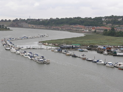
As I walked across it started to drizzle, and I was slightly disappointed by the views from the bridge, which despite its height were not particularly memorable. When I was halfway across a high speed train roared along the Channel Tunnel Rail Link bridge off to my right; the sound of the train being far lower than the constant drone of the cars driving past. I made my way to the western bank and climbed up the cycle path to join the road that I had walked down on the previous walk. There are actually three bridges; the original M2 Bridge having been joined by two others in 2002; a second M2 bridge and another bridge carrying the CTRL. Having done this, I turned around to walk back across the bridge, having joined up with the North Downs Way once again.
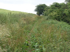
Near Nashenden Farm I was surprised to find a bright red sleeping bag hung up on a barbed wire fence; whether someone had dropped it off a rucksack or if it had been left as litter, I do not know. A short distance further on I crossed the CTRL line on a bridge; the abutments were too high for me to look over, but I could take photos by holding my camera with outstretched arms. A very pleasant walk followed, as the path climbed up a small hill, from where some good views of the Medway Bridges were available. At Ringshill Place the path became a track, and this led me on southwards, the rough path underfoot being quite ha4rd on they underside of my feet; I found myself wishing for a grassy path instead. Two Alsatians barked aggressively at me near Burham Hill Farm, and shortly afterwards I passed a sign at the top of the drive leading down to the Robin Hood Inn; a pub that is literally in the middle of nowhere.
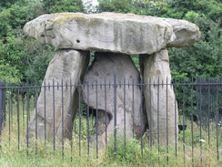
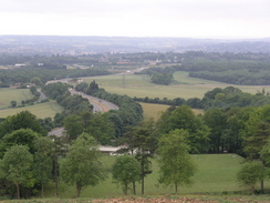
The road was surfaced as it continued on with houses on either side; it was trying to rain as I walked, soon reaching the picnic site on Bluebell Hill. The views from here were superb, but the most notable thing for me was a large stone memorial to a medical helicopter that crashed near the site in 1998 after hitting power lines, killing the three men on board. It was a nice memorial, and was set off well by the expansive views over the plains to the south. From the car park a short path led on to the A229 dual carriageway, where I was concerned to see a sign diverting the North Downs Way off to the left due to flooding; there had been heavy rain in Kent a few weeks earlier. As the diversion meant that I would miss seeing Kit's Coty burial chamber I decided to walk on rather then follow it, and figure out a way around the flooding when I reached it. A noisy path dived below the embankment carrying the road, and it was a nondescript stretch of path until I reached a path that led off to the Kit's Coty burial chamber. This is a proud monument of a capstone lying on top of three other stones, now sadly guarded by some fiercely pointed railings. Dating from between 4,300 and 3,000 BC, it was once part of a 70-metre long barrow, but sadly that has all now been removed. It is a shame that such a monument should stand so close to a main road, but it is easy to see why it was built here; the views over the plains from this field are superb.
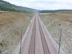
Eventually I managed to drag myself away from the scene, and I started walking along, meeting a road before diverting off down a track towards the A229 once more. At the road I discovered the reason for the path diversion; the underpass below the dual carriageway was flooded. The tidemark on the concrete walls of the underpass showed that the water level had been much higher, but even so I really did not fancy wading through the water, especially as right beside the underpass there was a petrol station and the water seemed particularly scummy. Instead I studied the map, and decided to divert along the road for a few hundred yards to where a road bridge led under the dual carriageway. This I did, and when I saw a pub at the road junction I decided to nip in for a drink. They sold Abbot, so I had a pint and used it to wash down a lovely cheese and ham toasted sandwich. The rest did me good, and as I headed off I felt much refreshed. I had little choice but to follow a road uphill eastwards for a hundred yards, before dropping down a churned-up bridleway back towards the Downs Way. Just before the bridleway reached the Way it passed right over a portal of the 3km-long North Downs Tunnel, carrying the CTRL under the escarpment and into the Medway valley. The tunnel portal was fairly interesting for a concrete structure, and I was pleasantly surprised by the extreme neatness of the permanent way - the track and ballast was in immaculate condition.
I headed back down to the underpass under the A229 to have a look at the flooding from the other side; it was obvious that I had made the right decision to divert around the underpass, as the water seemed even more disgusting from this side. I rejoined the Way, and followed as it crossed over the CTRL on a bridge and started climbing uphill through some woodland. Before I had gone far a stone was in a clearing to my left; I was expecting the White Horse Stone, a single stone forming the only remnant of a chambered tomb. Unfortunately someone had scrawled graffiti over the stone - a sad and maddening thing for someone to have done to something so ancient. Disgusted, I started a steep climb up some steps towards the top of the hill, which caused me to puff a little before the gradient finally slackened. Once at the top the path emerged from the trees and started skirting the edge of them eastwards towards Harp Farm, after which it continued on. I was certain that the trees to me right were blocking good views, and when some power lines streaked down the hillside the resultant gap in the trees proved this to be the case.
The path headed downhill towards the village of Detling, a pretty village that was cut in two by the A249 road. When I reached the dual carriageway I was surprised to see the North Downs Way sign pointing me off to the right when the map showed the path going to the left; I followed the sign and I soon found the reason, a bridge called Jade's Crossing that flew over the road. When I reached the base of the bridge I was touched to find that it was named after Jade Hobbs, an eight year old girl who was killed crossing the road with her grandmother. Five pedestrians have died at the crossing over the years, and the bridge was built in commemoration of all of them after a long local campaign. I found the bridge and the plaque to be quite poignant, and I left some money in the collecting box before crossing the bridge.
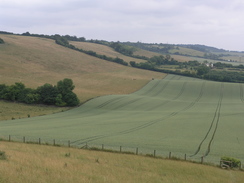
Detling itself turned out to be a pretty place, and I resisted the temptation to go into the pub and instead walked on. I was just wondering how I would get back to the old route of the Way when a sign pointed to the left off the lane, passing a filed where people were playing cricket, their white clothes contrasting with the green grass and the sky to make a quintessential English scene. This path led to a climb up slowly onto the top of the escarpment, and the views along the scarp were good - indeed this stretch of the walk was in many ways the best of the North Downs Way so ar, which surprised me considering it is so near to a motorway. The path headed up and down as it headed eastwards, making it a far more strenuous walk than I had been expecting, before skirting around Thurnham Castle, a twelfth century flint castle that I only saw the tree-covered mound of.
More ascents and descents followed, none of them particularly large, but all of them enough to make my tired legs ache as I climbed, and I was relieved when the going became flatter and easier. There were large stretches without the trees that have been a seemingly near-constant companion along the high sections of the path from the start of the Way at Farnham. I was really enjoying the walk, and my mind started to wonder if I could extend the walk a few miles, perhaps as far as Harrietsham or Lenham. As I approached Hollingbourne I realised that I could make neither without forcing myself to have a long wait for the train, and therefore I was forced to make my way down into Hollingbourne. This was fortunate, for as I reached the point in the village where the Way diverts off to the left to head out of the village I realised that I had some bad chaffing on my thighs.
I stopped by an information board outside the pub and contemplated going in for a quick drink as I was slightly early for my train; I decided against it and instead started a leisurely walk down towards the station, which is about a mile away from the North Downs Way. On the way I passed the attractive little church, and before long I found myself walking up the long approach road to the railway station. I got there about twenty minutes before the train was due, which gave me a welcome period of relaxation before it came.
Directions
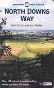
The walk is also covered in detail in the North Downs Way National Trail Guide, by Neil Curtis and Jim Walker, ISBN 1 85410 853 0, published by Aurum Press Ltd.
There are two exceptions to this. Firstly, I had to get from Strood station to the western end of the Medway bridge, where I had left the North Downs Way a fortnight earlier. As the route I used before was uninteresting, I decided to walk along the eastern side of the river. Leave Strood Station and turn left, to head south along the B2002 Station Road. This passes under a high railway viaduct before ending at the A2. Turn left and walk southeastwards along the road; at an underpass cross over to the southern side of the road. Cross the Medway using Rochester bridge, and once on the eastern bank turn right at a roundabout to start following the Esplanade southwards. After a hundred yards a path starts off to the right, skirting the shore past some new houses. Eventually this meets the road once again, and once this curves to the left continue straight on along a path through a nature reserve. Once this meets a road, turn left and follow Manor Lane as it heads uphill. When this road ends at a T-junction, turn right and follow a road as it heads downhill. At the place where the road heads under the Medway Bridge, a cycle path leaves to the right; climb up this path, which leads up to the bridge. A path leads across the bridge, before climbing up to meet the A228 and the North Downs Way.
The other alteration was at the end of the walk; when the North Downs Way leaves Hollingbourne by turning left to head east out of the village by the pub, turn right and start heading down the road for a short distance downhill until he road starts to curve to the left by the church. Here turn right, and walk along a path that skirts southwestwards past the church. The path is paved as it heads across a field before ending at a road; here continue straight on along the road; it soon passes under a railway line; after it does so turn right along a road that leads northwestwards below the railway line for a few hundred yards until the railway station is reached.
Distances
| From | To | Distance (m) | Ascent (ft) | Descent (ft) |
|---|---|---|---|---|
| Strood station | Medway Bridge | 3.4 | 384 | 269 |
| Medway Bridge | Kit's Coty | 5.8 | 850 | 676 |
| Kit's Coty | Detling | 5.8 | 925 | 843 |
| Detling | Hollingbourne | 5.8 | 1240 | 1322 |
| Hollingbourne | Hollingbourne station | 1.0 | 20 | 89 |
This makes a total distance of 21.8 miles, with 3419 feet of ascent and 3199 feet of descent. Note that the ascent/descent figures for the Medway Bridge stretch may be wrong, as Anquet uses the contours of the land surface and not the bridge to calculate altitude.
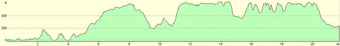
For more information on profiles, ascents and descents, see this page
Transport
There are regular train services between Hollingbourne and Strood, changing in Maidstone en route. This change involves walking between Maidstone Barracks and Maidstone East railway stations, which taken five to ten unhurried minutes.
Disclaimer
Please note that I take no responsibility for anything that may happen when following these directions. If you intend to follow this route, then please use the relevant maps and check the route out before you go out. As always when walking, use common sense and you should be fine.
If you find any information on any of these routes that is inaccurate, or you wish to add anything, then please email me.
All images on this site are © of the author. Any reproduction, retransmissions, or republication of all or part of any document found on this site is expressly prohibited, unless the author has explicitly granted its prior written consent to so reproduce, retransmit, or republish the material. All other rights reserved.
Although this site includes links providing convenient direct access to other Internet sites, I do not endorse, approve, certify or make warranties or representations as to the accuracy of the information on these sites.
And finally, enjoy your walking!
This walk was mentioned in the following routes:
| The North Downs Way |
Nearby walks
| # | Title | Walk length (miles) |
|---|---|---|
| 176 | Gravesend to Rochester | 17.2 |
| 281 | Stanford-le-Hope to Wennington | 16.9 |
| 285 | Stone to Cliffe | 13.6 |
|
|

|