Walk #681: Hollingbourne to Chilham
 |
 |
|
General Data
| Date Walked | 09/07/2005 |
| County | Kent |
| Start Location | Hollingbourne station |
| End Location | Chilham station |
| Start time | 10.48 |
| End time | 18.42 |
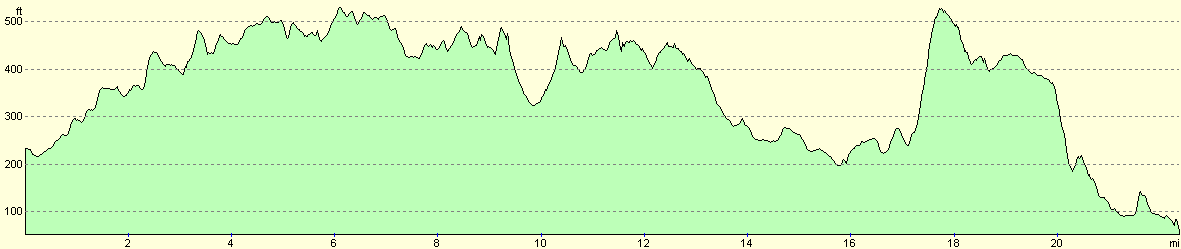
| Distance | 22.9 miles |
| Description | This was a straight forward walk, following the North Downs Way eastwards before entering woodland at the start of the Canterbury loop. |
| Pack | Today I carried my 30-litre Karrimor Hotrock rucksack, containing my waterproofs, a few odds and ends such as spare batteries, my Psion 5 and three litres of water. |
| Condition | I feel fairly fine after this walk, and have no significant problems to report. My right shoulder aches slightly, but this is not a major problem. I appear to have no blisters, which is quite a relief. |
| Weather | Today started cloudy, although it never threatened to rain at any time. Towards the evening this lifted, to leave mainly blue skies with only patchy clouds. All of this meant that it was a comfortably warm day for walking. |
| OS map | Landranger number 188 (Maidstone & The Weald, Royal Tunbridge Wells) and Landranger number 189 (Ashford & Romney Marsh, Rye & Folkestone) |
 |
 |
|
 |
 |
|
Map of the walk
Maps courtesy of Google Maps. Route for indicative purposes only, and may have been plotted after the walk. Please let me have comments on what you think of this new format. For a detailed table of timings for this walk, please see the table file.
 |
 |
|
Notes
For this weekend I had planned the next couple of days of my North Downs walk, from Hollingbourne eastwards towards Folkestone or even perhaps Dover. This seemed like a good plan, although when it came time for me to try to book accommodation I found that there was none available in Stowton or any of the surrounding villages that would be convenient for Saturday night. To make matters worse there is no convenient public transport from Stowton back towards Hollingbourne. This would leave me with a 16-mile walk today and a 16 mile walk to Folkestone or a longer 23-mile walk to Dover tomorrow. As I wanted to do the longer of these I knew that I would need an early start in the morning, and so rather than book into a B&B in Wye I decided to sleep on may car instead. I therefore found myself setting off from Cambridge far later than I normally do, and after a leisurely drive I found myself pulling into the station car park in Hollingbourne. As I was pulling all of my kit together and packing my rucksack I was concerned to see some teenagers acting boisterously nearby. the car park is fairly remote and I was concerned about having my car broken into. I daresay that these uncharitable thoughts about youths is a sign of getting older!
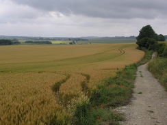
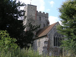
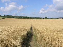
I found the mile walk up to the North Downs Way in the village to be enjoyable, and I took a few photos of the church to go along with the ones that I had taken last week. The initial stretch of path took me eastwards along a surfaced road, and this led me to be concerned about the state of my feet if this continued to be the case all day. Fortunately the tarmac soon ended, and the track continued on eastwards as a green lane. For the first time on the North Downs Way the path stuck rigidly to the base of the downs instead of climbing up to the top of them; despite this I got some good views when the trees surrounding the path allowed. Immediately to the north of Harrietsham the track joined a road, and the Way headed eastwards along this, passing the Marley Works (quite what they make there I do not know), before taking another green lane onwards.
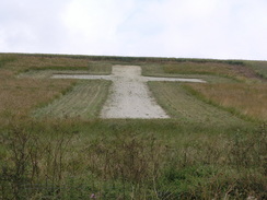
The Way joined a road for a short distance before another green lane took me on to the first real item of interest today - a war memorial cross cut into the turf of the hillside to the north, commemorating the dead in both World Wars. It was a nice sight, and a bench immediately beneath the bottom of the cross gave some superb views to the south, and I paused to admire them for a couple of minutes before moving on. Unfortunately there was not much of note for the next few miles, as the Way took a chain of footpaths and green lanes southeastwards, passing Hart Hill before reaching the A252 above Charing. As there was a pub marked on my National Trail guide nearby I diverted off the road and down into the village; I was therefore annoyed when I could find not trace of the marked pub. This annoyance was soon put to rest by the village of Charing itself, which turned out to be a superb little village, with some fascinating buildings to study as I strolled down the hill towards the centre of the town.
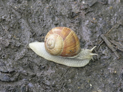
Eventually I found a pub (the Royal Oak), and, relieved, I went inside and ordered two drinks - a pint of bitter and a pint of orange and lemonade, whilst I read a newspaper detailing the atrocities in London of a couple of days earlier. The newspaper made for depressing reading, and after half an hour I had drunk the pints and got my kit together to leave. The journey back up through the village was enjoyable, and I made a little diversion up towards the church, which was bedecked in scaffolding that prevented me from getting a good view of it. Once back on the Way I followed it as it headed southeastwards, initially following a road before diving into some woodland on a track. When on this track I nearly stepped on one of the largest snails that I have seen for some time; I diverted my foot away from it in time, and I stopped to take a couple of photos of it, as it made an attractive sight. Watching the snail detect me and withdrawing its eye stems, before slowly extending them again was far more entrancing than I had been expecting.
A short stretch of road took me to Dunn Street, and this was followed by a footpath eastwards towards Eastwell Lake, where I resisted the temptation to visit the ruins of St Mary's Church beside the lake. A metalled lane continued on with the magnificent Eastwell Hall visible in the park to the left. The lane soon ended, and a footpath took me onwards, passing a sign that marked this as part of the E2 European footpath network, before heading downhill, crossing a road and leading to the centre of the village of Boughton Lees. I skirted the side of the village green and passed a bustling pub, and enjoyed studying the village in the sunlight. I was growing increasingly uneasy as a plan was starting to form in my mind; a short distance out of the village the Way forks; one branch going north to Canterbury and the other east to Folkestone. It had been my intention to walk to Wye today on the Folkestone branch, but I was still feeling very fit, and a glance at the map showed a railway station at Chilham, about six miles north on the Canterbury stretch. This six miles would give me a much longer and rewarding day, and as I was in no hurry it was very tempting to change my plans. A road took me northeastwards out of the village, and before I knew it I reached the junction in the paths. I walked around for a few minutes weighing up my options, before eventually turning left and heading along the footpath towards Canterbury.
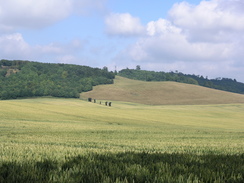
This was a radical change in my plans as I had always envisaged doing the loop via Fokestone, and it took a little time to get used to the mental shift in plans. Additionally, I had no idea about the train times from Chilham to Hollingbourne, so as I strolled north I used my mobile phone to get the train times For this reason I strolled past the attractive church at Boughton Aluph without giving it much of a look, and by the time that I had obtained the train times I was approaching Soakham Farm. Shortly after this the path headed steeply uphill onto Soakham Downs, before entering King's Wood. The views back to the south from the ascent were superb, and I stopped frequently to allow all the views to soak in. The Way then skirted the top edge of the downs through the wood for a couple of miles; this proved to be an enjoyable woodland walk, even if the views were hidden by the trees. There is a set of cycle paths heading through the woods, and a few cyclists passed me as I strolled on.
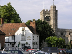
Just before the path dropped down our of the woods I passed a jogger, and we chatted for a few minutes about the Long Distance Walkers Association, He is a member and he tried to get me to join, but the internal politics of the organisation has always put me off, which is a great shame. He was an interesting bloke, and I enjoyed the chat a great deal. Unfortunately I had a train to catch, so I bade him goodbye and headed off down a track, that led on to a road that skirted northwards past Chilham Park. At one stage I could hear a tannoy coming from the park to my left, and my curiosity was assuaged when I discovered fences being set up, presumably for some horse event. I soon found myself striding into the centre of Chilham itself, which turned out to be a beautiful place. To the southwest of the market square is Chilham Castle, and all around the square are pleasing half-timbered buildings. The place was bustling on this Saturday evening, and I stopped to look at a pub on the square, which had an amusing 'grumpy landlord' sign outside it. Whilst taking a photo of this a group of people sitting at a table asked me to take a photograph of them, and naturally I obliged.
I then left the Way for the day, to make my way down through the village towards the railway station. As I headed away from the centre of the village it became mess pretty, and the last few hundred yards to the station were hard on my tired feet. I reached the station with a few minutes to spare before my train, and the journey back to Hollingbourne was punctuated by a change of trains at Ashford International. I sat down on the train to Ashford on some seats opposite a French lady (whose clothing designated her as French before she even spoke), and for the first couple of minutes she gave me curious looks before getting up and moving into the next carriage. I can only assume that my slightly dishevelled appearance and my rucksack had worried her after the events of a few days before. The train arrived back at Holingbourne shortly after eight, and I promptly drove to a pub in the village to get a meal, before driving back to the station in order to get what turned out to be a restless night's sleep.
Directions
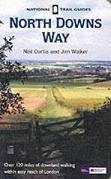
The walk is also covered in detail in the North Downs Way National Trail Guide, by Neil Curtis and Jim Walker, ISBN 1 85410 853 0, published by Aurum Press Ltd.
There are two exceptions to this at either end of the day. At the start of the walk, leave Hollingbourne station and turn left to walk along the long approach road beside the railway embankment. When the road ends at a T-junction, turn left and pass under the railway bridge. The road immediately curves to the left; at the end of the bend turn left along a footpath that heads northeastwards across a field towards Hollingbourne Church. When the footpath ends at a road turn left and follow the road as it heads northeastwards for about a hundred yards until the North Downs Way is met beside the Dirty Habit pub.
The other exception is at the end of the walk; when the square in Chilham is reached by the church turn right and start walking eastwards downhill along a road. This soon joins Bagham Road, which in turn ends at the A252. Follow the A252 eastwards for a few yards until it reaches the A28 and then follow this road northeastwards for about fifty yards; Chilham railway station is along a road that leads off to the right, opposite a B&B.
Distances
| From | To | Distance (m) | Ascent (ft) | Descent (ft) |
|---|---|---|---|---|
| Hollingbourne station | Hollingbourne | 1.0 | 89 | 20 |
| Hollingbourne | Charing | 9.4 | 873 | 784 |
| Charing | NDW junction | 6.1 | 505 | 617 |
| NDW junction | Chilham | 5.7 | 564 | 643 |
| Chilham | Chilham station | 0.7 | 23 | 95 |
This makes a total distance of 22.9 miles, with 2054 feet of ascent and 2159 feet of descent.
For more information on profiles, ascents and descents, see this page
Transport
There are regular services running between Chilham and Hollingbourne railway stations; you have to change at Ashford International station on the way.
Disclaimer
Please note that I take no responsibility for anything that may happen when following these directions. If you intend to follow this route, then please use the relevant maps and check the route out before you go out. As always when walking, use common sense and you should be fine.
If you find any information on any of these routes that is inaccurate, or you wish to add anything, then please email me.
All images on this site are © of the author. Any reproduction, retransmissions, or republication of all or part of any document found on this site is expressly prohibited, unless the author has explicitly granted its prior written consent to so reproduce, retransmit, or republish the material. All other rights reserved.
Although this site includes links providing convenient direct access to other Internet sites, I do not endorse, approve, certify or make warranties or representations as to the accuracy of the information on these sites.
And finally, enjoy your walking!
This walk was mentioned in the following routes:
| The North Downs Way |
Nearby walks
| # | Title | Walk length (miles) |
|---|---|---|
| 179 | Sittingbourne to Faversham | 13.9 |
| 289 | Sittingbourne to Faversham | 16.3 |
| 290 | Faversham to Reculver | 17.8 |
|
|

|