Walk #590: A circular walk between Spalding and Fosdyke Bridge
 |
 |
|
General Data
| Date Walked | 01/02/2004 |
| County | Lincolnshire |
| Start Location | Spalding Station |
| End Location | Spalding Station |
| Start time | 08.54 |
| End time | 14.35 |
| Distance | 18.6 miles |
| Description | This was a straightforward and quite enjoyable walk following the River Welland, although it was scenically fairly boring. |
| Pack | Today I carried my 30-litre Karrimor HotRock rucksack, which was filled with my waterproof leggings, water bottle, trainers and a couple of spare shirts, together with the usual assortment of odds and ends. |
| Condition | I feel absolutely fine after this walk, aside from a slight ache in my feet caused by using new boots. |
| Weather | The day started off bright and sunny, with a stiff breeze replacing the gales that predominated last night. As the day wore on the weather slowly deteriorated and the sky slowly clouded over, and at the very end of the walk it started to spit with rain, although this did not become heavy rain. |
| OS map | Landranger number 131 (Boston & Spalding) |
 |
 |
|
Map of the walk
Maps courtesy of Google Maps. Route for indicative purposes only, and may have been plotted after the walk. Please let me have comments on what you think of this new format. For a detailed table of timings for this walk, please see the table file.
Notes
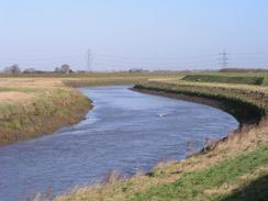
For some time now I had been wanting to walk from Spalding to Fosdyke Bridge, connecting Peterborough with my coastal walk and Boston. I had originally attempted to so this early in 2002 and my attempt had been forestalled at Fosdyke Bridge, the walk from Boston having been in cold and snowy weather. As I am due to start my new job tomorrow, I decided that doing a walk would be a good way to take my mind off it, and so I decided that I would finally do for this missing a stretch of walk. I was well aware that it took would hardly be a classic walk, and so when I set off the windy weather of the previous night was worrying as I would be very exposed on the flood banking beside the River Welland that I was planning to follow for the majority of the walk. Fortunately although there was still a stiff breeze the wind had died down considerably, and so it did not prove to be a significant problem.
When I arrived at Spading Station I was keen to set off, so I spared no time in putting all my gear on. This included putting on a brand new pair of boots, the fifth pair of Scarpa Trek 2's that I have used (as they are no longer making them, I have a sixth pair in storage ready for when this pair is worn out). The initial walk was through Spalding to the River Welland, and the town seemed to be half-asleep at this time on a Sunday morning. A footbridge took me across the River Welland to the eastern bank of the river, which I was due to follow northwards all the way to Fosdyke Bridge.
I soon reached the junction between the River Welland and the Coronation Channel, a much larger watercourse designed to prevent the centre of Spalding from flooding. Once I crossed the channel I joined a footpath that runs along the top of a flood bank; the initial stretch of this had been churned up by the tracks of a large dragline, and I found the unworn tread of my new boots to be forming large mud balls as I walked, making the going hard. Fortunately this situation only lasted for a few hundred yards, after which the path was grassy.
On the other, western, side of the River Welland I could see a large power station under construction, its two chimneys and the attendant cranes dominating the billiard-table flat Fenland skyline. Construction on this scale always fascinates me, and I found myself wishing that I could be on the other side of the river to get a closer look. Alas that was not to be, and once I had crossed under the busy A16(T) road I left it behind me. The rest of the going to Fosdyke Bridge was exceptionally easy going, it simply being a case of following the flood banking northeastwards all the way to the bridge. At one point I passed a trig point that is marked on the map but which had almost totally been submerged by the flood bank. Only the top foot of the pillar was visible, and there was no chance of recording the serial number from the flush bracket at its base.
The wind, which for most of the journey had been coming from behind me, helped me reach Fosdyke Bridge much earlier than I had been expecting. I felt quite strange when I reached there; I was satisfied at having filled in this long-standing gap in my walks, but I was also quite saddened at the memory of reaching there on my coastal walk. I felt quite nostalgic about it, and a large part of me wished that I was still on that trip. Sadly I had to turn around and leave the bridge without going to visit the adjacent pub, which would have been nice. There have been three bridges at Fosdyke Bridge; the first was designed by Sir John Rennie and was completed in 1815. It had a lifting middle section that allowed ships to get through to Spalding.
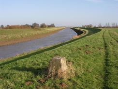
The second bridge replaced the first one, and was erected of cast iron and blue engineering brick in 1911. It had a swing section (seemingly similar to the remaining bridge at Sutton bridge) to allow ships through. The third and final bridge, made of reinforced concrete, opened in 1990, as the second bridge was not wide enough for modern traffic. It appears to have none of the grace of the earlier bridges, which looked like some form of massive Mechanno set! For the first three miles back I followed a footpath that ran along the flood bank on the western side of the river; this proved to allow quite fast walking as there was a rough track along it. Immediately beside some power cables the track left the flood bank, and I was forced to follow the flood bank past a field containing a Highland Cow to reach the pub at Surfleet Seas End.
The name of the village belies exactly how near the village was to the sea at one time - the Fenland drainage schemes having taken the sea much further away and leaving the village well and truly away from the sea. From here there was little point in continuing along the western bank of the River Welland as the footpath ended after a couple of kilometres, so I chose to follow the Macmillan Way (which I had been walking along from Fosdyke Bridge) as it headed southwestwards along the southern bank of the River Glen through Surfleet to Pinchbeck. Again the going was good, but as much of the area was one large linear village there was much more to see than there had been on the walk along the Welland, including a golf course that was totally devoid of golfers, even on a Sunday afternoon!
When I arrived at Pinchbeck I crossed the railway line at a pedestrian crossing and reached a road by an attractive thatched pub. The rest of the walk followed byways and roads south for a couple of miles; a quite boring walk, although most of the roads were quiet, and the by-ways were only busy with the ever-present suburban dog walkers. As I approached Spalding Station it started to drizzle, and although this never became rain it caused me to increase my pace; my feet suffered for this. I was therefore quite relieved when I reached the station, only to find that the entrance to the car park was blocked by an articulated lorry, and I had to wait ten minutes for the lorry to move before I could leave.
Directions
This walk starts off at the railway station in Spalding. Leave the railway station car park and then turn right along the A151 for a few yards before turning left down a road that heads eastwards past a supermarket. This road becomes Swan Street, and when this meets New Road follow New Road for a short distance until the B1172 Westlode Street is reached. When the B1172 road turns sharply to the right after a short distance turn left down Albion Street, which heads northeastwards along the western bank of the River Welland. When a footbridge is reached on the right cross it to gain access to the eastern riverbank, and follow the B1173 Commercial Road northeastwards until a roundabout is reached.
Cross over the roundabout, and when the road curves to the right on the other side turn left down a road called Roman Bank. When this crosses the Coronation Channel near some large floodgates turn left to take a footpath that runs along the top of a flood bank. This footpath follows the Coronation Channel for a few yards to the junction with the River Welland, and then follows the River Welland northwards for a little over a kilometre until the A16(T) road is reached. It is possible to walk under the road bridge over the river, and once on the other side rejoin the flood bank and follow it northwards for a little under six miles until the A17(T) road is reached at Fosdyke Bridge.
Once the A17(T) is reached, turn left to cross Fosdyke Bridge. On the other side turn left down some steps, and then follow a footpath that heads southwestwards along the northern bank of the River Welland. This part of the walk follows the Macmillan Way, a 290-mile long path from Dorset to Boston. Follow the path as it heads along the flood bank (there is a handy and firm track available). As it passes under some power lines the track leads off to the right; continue straight on along the flood bank until it ends at Reservoir Road in Surfleet Seas End. Join the road and follow it as it heads southwestwards past the Ship Inn; a few yards further on turn left to cross the River Glen using a road bridge.
On the other side of the bridge turn right to join a footpath (still following the Macmillan Way) as it heads westwards along the southern bank of the River Glen. The path soon crosses a little drain and skirts past a golf course before reaching the A16(T). Cross the road and continue on along the footpath on the other side; a mile later a bridge carrying the B1356 road over the river is reached in Surfleet. Cross the road and continue on along the footpath as it heads southwestwards beside the river, before turning to take a more southerly course. On the northern outskirts of Pinchbeck it turns to head west again, passing close to a large water tower on the left. Cross over a railway line using a pedestrian crossing, and on the other side continue on for a short distance until the B180 road is reached by the Ship Inn.
Turn left and follow the B1180 as it climbs up to cross the railway line on a bridge. Beside a chapel on the left, turn right down Rotten Row and follow this as it curves to the left. At a junction turn right down Holt Lane, and then left down Penny Toft Lane. When this road curves sharply to the left continue straight on southwards along Blue Gowt Lane. When the lane turns sharply to the right continue straight on down a track, which leads to a bridge over Vernatt's Drain. On the other side of the bridge the lane becomes Two Plank Lane, which can be followed southeastwards until it ends at a T-junction.
At the junction turn right down Wygate, and then turn left to head southwards down Woolram. When this road ends at a T-junction turn left down Pennygate for a short distance until it ends at the B1356 Park Road, and then turn right to head southwards for a few hundred yards down the B1356 road, immediately crossing the tailway line on a level crossing and then paralleling to the west of the railway line. When the road ends at a T-junction with the A151 road turn left along the A151 and cross the railway line; it turns to the left and heads back to the railway station, where this walk ends.
Distances
| From | To | Distance (m) | Ascent (ft) | Descent (ft) |
|---|---|---|---|---|
| Spalding Station | Fosdyke Bridge | 8.1 | 3 | 16 |
| Fosdyke Bridge | Surfleet | 5.5 | 20 | 20 |
| Surfleet | Spalding Station | 5.0 | 16 | 3 |
This makes a total distance of 18.6 miles, with 39 feet of ascent and 39 feet of descent.
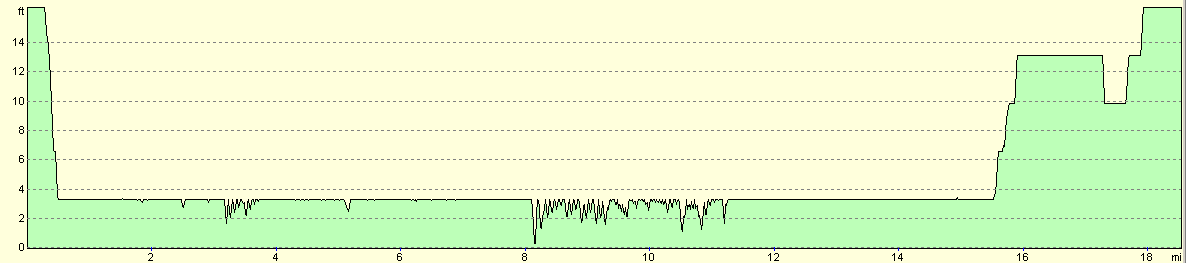
For more information on profiles, ascents and descents, see this page
Disclaimer
Please note that I take no responsibility for anything that may happen when following these directions. If you intend to follow this route, then please use the relevant maps and check the route out before you go out. As always when walking, use common sense and you should be fine.
If you find any information on any of these routes that is inaccurate, or you wish to add anything, then please email me.
All images on this site are © of the author. Any reproduction, retransmissions, or republication of all or part of any document found on this site is expressly prohibited, unless the author has explicitly granted its prior written consent to so reproduce, retransmit, or republish the material. All other rights reserved.
Although this site includes links providing convenient direct access to other Internet sites, I do not endorse, approve, certify or make warranties or representations as to the accuracy of the information on these sites.
And finally, enjoy your walking!
Nearby walks
| # | Title | Walk length (miles) |
|---|---|---|
| 175 | Spalding to Peterborough | 19.5 |
| 181 | Boston to Fosdyke Bridge | 11.6 |
| 249 | Gibraltar Point to Boston | 24.7 |
|
|

|