Walk #804: South Haven Point to Worth Matravers
 |
 |
|
General Data
| Date Walked | 12/01/2008 |
| County | Dorset |
| Start Location | South Haven Point |
| End Location | Worth Matravers |
| Start time | 08.26 |
| End time | 15.33 |
| Distance | 14.8 miles |
| Description | This was a pleasant walk along the first fourteen miles of the South West Coast Path, heading thorugh Swanage. |
| Pack | Today I carried my 30-litre Karrimor rucksack, filled with waterproofs, a book and other odds and ends. |
| Condition | My left knee got slighty hurt when I slipped down the last hill, on the way to Worth Matrevers. Aside from that I am tired, but feel fine. |
| Weather | The day started off sunny, with scarcely a cloud in the sky. However as the day went on the clouds rolled in, until at the end of the day there were some fairly ominoud clouds hanging around overhead. |
| OS map | Landranger number 195 (Bournemouth & Purbeck, Wimborne Minster & Ringwood) |
 |
 |
|
 |
 |
|
Map of the walk
Maps courtesy of Google Maps. Route for indicative purposes only, and may have been plotted after the walk. Please let me have comments on what you think of this new format. For a detailed table of timings for this walk, please see the table file.
 |
 |
|
 |
 |
|
Notes
My partner, Sencan, wanted to start doing some more walking with me this year, and knowing my love of the coast she asked if we could do bits of the South West Coast Path together. Naturally I jumped at the chance, and planned an interesting walk from the start of the walk opposite Poole. We had a good drive down, the highlight being passing the dramatic ruins of Corfe Castle. By the time we reached the car park at South Haven Point I was in need of a toilet, so as Sencan looked for somewhere to pay I ran up to the toilet block. It was locked. Cursing, I looked around, but there was nowhere discreet that I could use. Instead I ran back to the car, put my boots on and packed up my kit, eager to start the walk so we could get somewhere private.
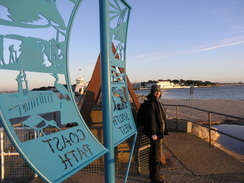
The chain ferry that links South Haven Point with Sandbanks across the narrow mouth of Poole Harbour was running, and one of the old chains lay on the ground. Next to this was the blue sign marking the starting (or finish) point of the South West Coast Path. It had been a few days over five years since I had last been here, and I was far less nervous. Then I was on my Coastwalk, and I was nervous about tackling this, the longest national trail in Britain. I had completed it with relative ease, and was looking forward to doing bits of it again.
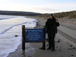
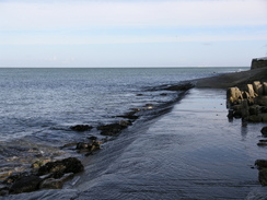
We took some hurried photographs of each other by the sign, before heading off by the beach. Soon I found a secluded spot by some low sands dunes, and hurried to catch up with Sencan as a large ferry passed us, seeming to tower overhead. It seemed far too close to the shore, showing exactly how narrow the mouth of the harbour is. The beach walk was easy, and we soon passed a sign denoting the limits of the Nudist beach. We both wondered if we should strip off for this stretch but thought against it - it was January, and although sunny was far from warm.
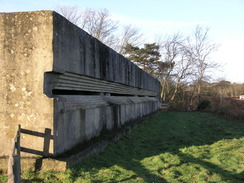
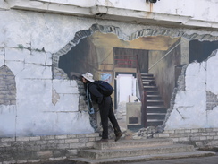
At Studland we went into the toilets, and once out continued the walk. We took a diversion of the coast path that led to some old Second World War defences on Redend point, including a long concrete bunker with a long slit window. It was divided into three sections, and was a very impressive structure. After this we headed down to the beach for a short distance, and had to negotiate a short stretch where the tide was washing against the cliffs.
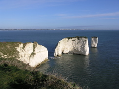
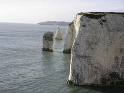
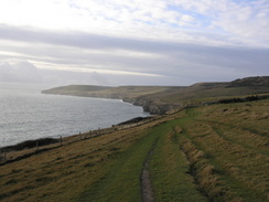
A pleasant walk followed uphill to the first truly spectacular part of the path, the cliffs around Handfast Point. The cliffs are made of chalk, and a series of stacks head out to sea, including Old Harry and, further out to sea, Old Harry's wife. Further south along the coast was another couple of stacks called the Pinnacles. They were superb to look at, and there was a distinct path where braver people than me had headed out to the very edge of the point. I looked at it and rapidly decided against it; there are far more pleasurable ways to die.
The path followed the cliffs around and slightly below the summit of Ballard Down, and then started a steep descent. This was muddy, and Sencan had difficulty so I gave her one of my walking poles. She had never used these before, and soon vowed to buy a pair of her own. They eased her progress, and before long the gradient slackened. Behind us there were clear views of the cliffs.
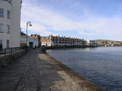
Soon the path diverted away from the cliffs and headed through New Swanage, eventually following a road down to the seafront in Swanage. There were a few people about, and on the beach blow the promenade were a series of wooden squares, the bases of beach huts that had been removed for the winter. Sencan seemed to be really enjoying herself, and was keen to continue on. This meant that we would need to get a taxi back, so we diverted towards the station, now the terminus of the preserved Swanage Railway. They gave us an estimated price, and we headed back to the seafront.
We were both in need of a rest, and as this was the last place of any size until the end of the walk we went into the Ship Inn. Sencan had a bowl of soup as I read the newspaper, and by the time that we set off once again we were both feeling much better. We followed the coast as closely as possible to Peveril Point, the waves lapping at our feet in a couple of places, and then headed uphill along Durlston Bay. The first stretch of this was enjoyable enough with good views to the north over Swanage, but as soon as the way joined a road it got worse.
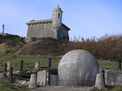
Eventually the way left the road and dived into Durlston Park, which was a more pleasant walk, although the trees removed most of the views of the sea. Durlston Head Castle was under renovation and the pub there was not open, so we continued along the coast path, passing a series of engraved stones and a fairly spectacular formal garden, dominated by a large carved globe made out of stone. A little further on we passed the Tilly Whim Caves, old underground quarry workings that had been open to the public at one time.
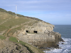
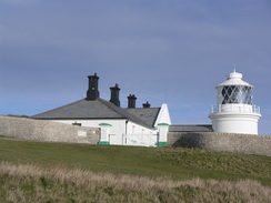
A mile marker post was passed before the Anvil Point Lighthouse was reached. The mile marker posts are sets of posts set a mile apart; they were used by the admiralty for sea trials of ships, to get their true speed. The clocks are started as one pair of the posts line up together, and stop as the next pair, a mile away, line up. It is a simple and probably very effective system, which has probably been made redundant in these days of Loran and GPS.
As we walked we passed a series of old quarries, showing how valuable this stone had been in the past. Several of the buildings in Swanage used to be in London; stone was exported to London for some of the fine buildings there, and on the journey back the ships could bring the remains of buildings that had been demolished for reuse. London's loss was Swanage's gain. There was a tent on the floor of one of the quarries, and just above it were two people climbing on the cliff face.
The path westwards was exceptionally muddy and Sencan was finding it hard going on tired legs. I gave her one of my walking poles, but still she was having difficulty. Since I have more experience than her of walking, anfd have surer footing (or so I thought) I gave her the other pole and walked on without any. This allowed her to go faster, but she was tiring fast. It had been my intention to walk around past St Aldhelm's Head and to get to Worth Matravers from the west, as I had five years previously, but it was clear that she would not make that walk in the time.
Instead, when we reached the old quarry at Seacobme Cliff we left the coast path and started heading inland, taking a more direct route to Worth Matravers. Initially this followed a pleasant and green valley called Seacombe Bottom, but this was soon followed by a stiff climb uphill, although it was rewarded with views of the strip lynchets on the hillside. There was then a steep but short descent into another valley, and I strode ahead of Sencan, who was picking her way carefully down with the poles. It was muddy underfoot, and shortly before I got to the bottom I slipped, with my left knee folding up underneath me. I lay down on my back as I unfolded my knee, and was alarmed to feel a little pain. Sencan soon joined me, and helped me get up to test my leg. It hurt, and although I could walk I was very glad that the end of the walk was only a short distance away.
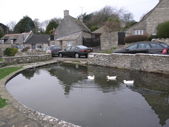
I struggled up the last hill, and soon we were sitting on a stone bench by the pond in Worth Matravers. It is a beautiful little village, with stone house scattered higgledy-piggledy about, and I started scraping mud off my boots as Sencan phoned up for a taxi. This soon arrived, and the woman who drove us back to South Haven Point was pleasant. Unfortunately when we got there the fare was double what we had been told it would be; we had little choice but to pay up, but it left a bad taste in my mouth. On the way back we went over the chain ferry, the first time that I have ever been on it, and this saved a fairly long drive around Poole Harbour. It had been an enjoyable enough walk, but I was hoping that I had not injured my knee too much.
 |
 |
|
 |
 |
|
Directions
| During this walk I followed the South West Coast Path, the route of which is detailed in the Ordnance Survey National Trail Guide 11, Exmouth to Poole (ISBN 1-854109-88-X). Unfortunately the route description is written in reverse to the direction that I am walking, but the 1:25,000 maps in the book are clear and the signs on the ground are very good. Also to be recommended is the South West Coast Path Association guidebook (ISBN 0-907055-04-4), which has less concise directions and no maps but does include accommodation details and grades each section of the walk according to difficulty. They also publish reverse directions, which are suitable for walking in the direction that I walked the route. They have a website at www.swcp.org.uk, which is well worth a visit. | 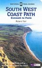
|
| 
| |
| |
| |
The only exception to this is at the end of the walk. Leave the South West Coast Path just before Seacombe Quarry is reached, and turn right to start heading inland on a path that runs along Seacombe Bottom. The path crosses a stream and then starts to curve to the left, climbing steeply uphill to the west. At the top of the hill continue westwards as the path descends and then climbs once more before ending at a track in Worth Matravers. Turn tight along this track and follow it for a short distance until it reaches the pond in the middle of the village.
 |
 |
|
Distances
| From | To | Distance (m) | Ascent (ft) | Descent (ft) |
|---|---|---|---|---|
| South Haven Point | Studland | 3.3 | 118 | 98 |
| Studland | Swanage | 5.1 | 1237 | 1253 |
| Swanage | Worth Matravers | 6.4 | 1952 | 1604 |
This makes a total distance of 14.8 miles, with 3307 feet of ascent and 2955 feet of descent.
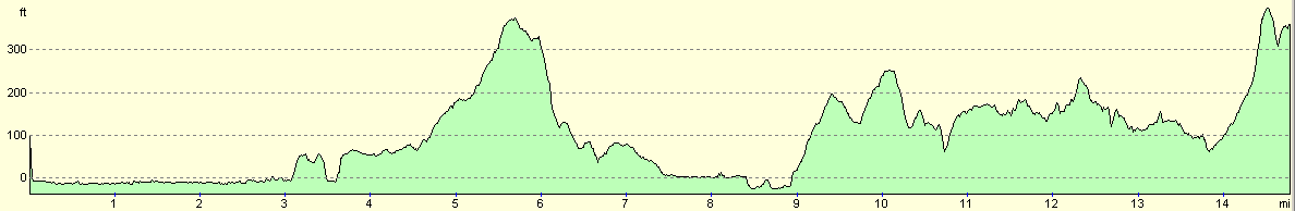
For more information on profiles, ascents and descents, see this page
Transport
We used a tazi to get back to South Haven Point; this took us on a rather roundabout route via Corfe Castle, and cost us nearly double the sixteen pounds that we had been quoted for the journey.
Disclaimer
Please note that I take no responsibility for anything that may happen when following these directions. If you intend to follow this route, then please use the relevant maps and check the route out before you go out. As always when walking, use common sense and you should be fine.
If you find any information on any of these routes that is inaccurate, or you wish to add anything, then please email me.
All images on this site are © of the author. Any reproduction, retransmissions, or republication of all or part of any document found on this site is expressly prohibited, unless the author has explicitly granted its prior written consent to so reproduce, retransmit, or republish the material. All other rights reserved.
Although this site includes links providing convenient direct access to other Internet sites, I do not endorse, approve, certify or make warranties or representations as to the accuracy of the information on these sites.
And finally, enjoy your walking!
Nearby walks
| # | Title | Walk length (miles) |
|---|---|---|
| 312 | Southbourne to Hamworthy Station | 15.3 |
| 313 | Hamworthy Station to South Haven Point | 18.0 |
| 314 | South Haven Point to Worth Matravers | 16.7 |
|
|

|