Walk #461: Dalreach to Rosneath
 |
 |
|
General Data
| Date Walked | 03/06/2003 |
| County | Strathclyde |
| Start Location | Dalreach |
| End Location | Rosneath |
| Start time | 08.35 |
| End time | 16.39 |
| Distance | 22.2 miles |
| Description | This was a surprisingly enjoyable day, despite the fact that most of the day was spent plodding along long stretches of roads. |
| Pack | Today I carried my 30-litre Karrimor HotRock rucksack, which was filled with my packed lunch, waterproof leggings, water bottle and a couple of spare shirts, together with the usual assortment of odds and ends. |
| Condition | My right ankle, which had been quite painful last night, was fine this morning and gave me absolutely no trouble, which is a relief. I had no other significant problems either, which is quite a relief. Later on in the evening I discovered two weird blisters on the back of my right ankle (see below for details). |
| Weather | The morning was nice and bright, with some sunny periods breaking through the cloud. At lunchtime there was a short drizzle shower, but this did not last long and most of the rest of the afternoon was dry, with only occasional light drizzle showers. The afternoon was cooler than this morning, but the wind was not too strong and so I still kept nice and warm. |
| OS map | Landranger number 63 (Firth Of Clyde area) and Landranger number 56 (Loch Lomond & Inveraray) |
 |
 |
|
 |
 |
|
Map of the walk
Maps courtesy of Google Maps. Route for indicative purposes only, and may have been plotted after the walk. Please let me have comments on what you think of this new format. For a detailed table of timings for this walk, please see the table file.
 |
 |
|
Notes
I was full of trepidation when I woke up this morning, as when I went to bed last night I was finding it hard to walk, as my right ankle had really been hurting. I climbed down the ladder from the bed above the cab in Mervan and gingerly put weight on my foot and found that there was absolutely no pain - whether it was the Ralgex that I sprayed on it before I went to bed or just natural healing, I do not know. I was so thankful that the pain had gone that it put me in a good mood that nothing could put me out of.
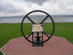
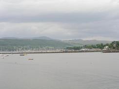
I was surprised to find that I quite liked Helensburgh, which for some reason I had always associated with heavy industry. This was quite mistaken; the short, stubby pier was covered in amusements, but the walk along the promenade gave some nice views over towards Gourock. The town was the birthplace of John Logie Baird, the inventor of television, and was also the place that the builder of the Comet, a very early steam-powered ship, lived. The original flywheel from the Comet is in Hermitage Park, and I passed a replica of the ship in Greenock yesterday.
I met Sam in a car park at Cairndhu Point, and I went in for a rest and to eat my lunch. We had a nice long chat, and as we did this there was a quick shower. For this reason I decided to put my coat on, and although there were some drizzle showers and it got colder in the afternoon I did not really need it on. I hate stopping to put on and take off my coat all the time, and I prefer just to keep it on if it looks as though it may rain.
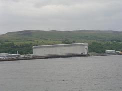
Before I reached Garelochhead I passed the large Faslane submarine base. There were some sailors playing football on some pitches inside the base, but what really fascinated me as I walked for a couple of miles alongside the base was the security fence. This was not so much a fence as a structure in its own right, and as I walked past it I tried without success to think of how I could get past it. Immediately beside the road there is a twelve-foot fence, with a roll of razor wire about three feet away from it. Down a little bank there were two more rolls of razor wire with another on top, all intertwined, and further down the bank there were three more rolls, with another beside them. It really was quite impressive, and I enjoyed tying to work out how I could potentially get through, and the answer that I came up with was 'with great difficulty!'. A little earlier I had passed the Faslane peace camp, a fairly grotty collection of busses and caravans. I am generally in favour of the nuclear deterrent (if only because of the sheer elegance of the engineering involved - not a terribly persuasive or valid argument, I must admit), and I am afraid to say that I think that it really is a lost cause.
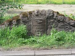
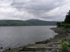
I stopped to have a little rest in Garelochhead, which was a surpassingly nice little town sitting at the end of Loch Gare. I sat down on a bench opposite the church, which much to my surprise had a plaque on it stating 'Elvis slept here 12th May 2002'. Now I thought that Elvis died in 1977, but it appears that he is alive and had been spotted asleep on a bench in Scotland last year! I was still feeling fit, and so to reduce the mileage that I have to do tomorrow to get to Arrochar I decided to walk on south along the western side of the loch for six miles. Fortunately the road was not too busy, and the views over the loch, whilst not spectacular, were nice enough to take my mind off the long road plod.
We had a lovely view from the car park in which we parked over the Clyde to Gourock and Greenock. It was nice looking out over the river to the towns, and watching the ferry plow to and fro across the river. I felt quite tired this evening, so I really did not feel like doing very much, which was probably to be expected as I have done about 107 miles in the last five days! Tomorrow I have to walk around the coast to Kilcreggan, and then head north along the eastern coast of Loch Long to Arrochar. This is going to be quite a long walk, although most of it will be along roads.
Later on this evening I was relaxing and lying down in Mervan when I had an itching on the rear of my right ankle. I scratched it, and then I realised that I had a couple of long, thin blisters around the back of my ankle. These blisters are very thin - almost straw-like - and a couple of inches long, and I have never seen anything like them before. As I had trouble with that ankle last night I wore a support brace today, and I can only assume that this has been rubbing to cause these strange blisters, although I never felt any discomfort whilst I was walking.
Directions
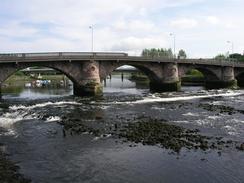
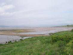
This walk starts off on a road near Dalreach Station, right beneath a tower block. Head towards the attractive Dumbarton Bridge over the River Leven and continue on southeastwards towards the mouth of the river down a road. When the road ends at some gates into an industrial area turn to the right along a path that leads to the riverbank. Follow the path along the riverbank, and it soon becomes surfaced as it heads along the river. It curves to the right, to head along the northern bank of the estuary. Eventually it becomes unsurfaced and I had to head through waist-high vegetation until I eventually reached a little beach that proved easier to walk along than through the grass, nettles and other assorted weeds. Just before the end of the beach the path turns to the right to head under a railway line and reach the A814 road in Ardroch.
Turn left to walk westwards along the A814 road. This soon curves to head northwestwards and enters Cardross, before continuing on for another couple of miles into Helensburgh and it becomes a short section of dual carriageway. Follow the road as it heads under one railway line and then immediately over another one, and slowly angles to follow the sea. Pass the short pier in the town and continue on past the car park at Crindhu Point and on into the village of Rhu. From here keep on the A814 road as it slowly curves to head northwards beside Gare Loch for a few miles, before it climbs up away from the loch slightly beside the Faslane submarine base. Continue on along the road with the fence of the base on the left. Eventually the road drops down to a roundabout, with the main entrance to the base on the left. Continue straight on down the B872 road, which curves around to meet the edge of the loch at Rowmore and follow this northward for about a mile into Garelochhead.
Follow the road as it curves around to the left, passing the large white church in the town, until it reaches a road junction with the B833 road. Turn left and head south along the B833 road, which follows the western side of the loch southwards for about five miles. The road is quite quiet, and the first settlement of any size that it passes through is Clynder. Shortly after this it passes through the village of Rosneath, and this walk ends a couple of hundred yards further on from the church in Rosneath.
Distances
| From | To | Distance (m) | Ascent (ft) | Descent (ft) |
|---|---|---|---|---|
| Dalreach | Helensburgh | 9.7 | 322 | 354 |
| Helensburgh | Garelochhead | 7.1 | 417 | 387 |
| Garelochhead | Rosneath | 5.4 | 515 | 505 |
This makes a total distance of 22.2 miles, with 1254 feet of ascent and 1246 feet of descent.
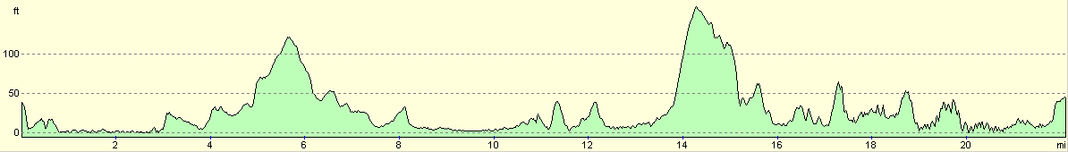
For more information on profiles, ascents and descents, see this page
Accommodation
There was not really anywhere convenient to park in Rosneath, so we drove the short distance into Kilcreggan for the night. There is a pub in the village and we had a lovely view from the car park in which we park.
Disclaimer
Please note that I take no responsibility for anything that may happen when following these directions. If you intend to follow this route, then please use the relevant maps and check the route out before you go out. As always when walking, use common sense and you should be fine.
If you find any information on any of these routes that is inaccurate, or you wish to add anything, then please email me.
All images on this site are © of the author. Any reproduction, retransmissions, or republication of all or part of any document found on this site is expressly prohibited, unless the author has explicitly granted its prior written consent to so reproduce, retransmit, or republish the material. All other rights reserved.
Although this site includes links providing convenient direct access to other Internet sites, I do not endorse, approve, certify or make warranties or representations as to the accuracy of the information on these sites.
And finally, enjoy your walking!
This walk was mentioned in the following routes:
| My walk around the coastline of Britain |
Nearby walks
| # | Title | Walk length (miles) |
|---|---|---|
| 459 | Fairlie to Fort Matilda | 19.1 |
| 460 | Fort Matilda to Dalreach | 21.1 |
| 462 | Rosneath to Ardgartan | 26.5 |
|
|

|