Walk #460: Fort Matilda to Dalreach
 |
 |
|
General Data
| Date Walked | 02/06/2003 |
| County | Strathclyde |
| Start Location | Fort Matilda |
| End Location | Dalreach |
| Start time | 07.40 |
| End time | 18.12 |
| Distance | 21.1 miles |
| Description | This was a surprisingly enjoyable days walk, the highlight of which was crossing the Erskine Bridge over the River Clyde. |
| Pack | Today I carried my 30-litre Karrimor HotRock rucksack, which was filled with my packed lunch, waterproof leggings, water bottle and a couple of spare shirts, together with the usual assortment of odds and ends. |
| Condition | I am quite tired after this long walk and long day, and I was glad when I reached the end. My left hamstring was okay after a night's sleep, but both of my ankles gave me a little amount of trouble at times. |
| Weather | Today was a lovely day, with sunshine and cloud and absolutely no sign of any rain, which I was quite glad about. There was not much wind, but the temperatures did not rise too high, meaning it was quite a lovely day for a walk. |
| OS map | Landranger number 63 (Firth Of Clyde area) and Landranger number 64 (Glasgow, Motherwell & Airdrie) |
 |
 |
|
 |
 |
|
Map of the walk
Maps courtesy of Google Maps. Route for indicative purposes only, and may have been plotted after the walk. Please let me have comments on what you think of this new format. For a detailed table of timings for this walk, please see the table file.
 |
 |
|
 |
Notes
I had been expecting this walk to be more than a little boring, as the vast majority of it was to be along roads. Fortunately although I did do a great deal of road walking, I did find other off-road routes that proved far better. In particular there was a nice riverside path that headed along the southern bank of the river eastwards from the impressive Newark Castle towards Finlaystone, which avoided walking along the dual carriageway. When this path ended I walked along the foreshore, and although at first there was a quite distinct path, but this soon ended. At one stage I had a little stream to jump over, but I did not quite make it and I ended up with my right trainer full of foul-smelling water. I was quite thankful when I reached the road once again, especially as I could avoid the main road by walking along a parallel road through the village.
I had a phone call from Sam in the morning, and she told me that she had suddenly felt ill whilst in the library. She had driven to the place where she was going to meet me, but she was still feeling ill and was slightly concerned. There was little that I could do over the phone except giver her a little sympathy, but I was concerned about her nonetheless and I increased my pace to get to her quicker.
Sam had arranged for me to have a radio interview as I was passing over the Erskine Bridge, but I expected that the noise from the traffic and the wind would be too much so I wanted to meet Sam and do the interview in Mervan. I was aware that it was going to be quite tight to reach her in time, and so I walked for fifteen miles with no break. This was a little too much, and when Sam met me in the middle of the bridge I was quite thankful (she thought that the walk might do her some good). When we reached Mervan, which was parked by Kilpatrick Station, I flopped in and collapsed down onto the seat before ravenously devouring my sandwiches. Sam was still feeling ill, but she still wanted to come into the city with me.
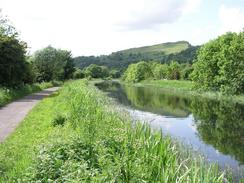
The rest of the walk westwards from Kilpatrick was surprisingly nice - the first stretch as far as Bowling was along he western end of the Forth-Clyde canal, and this was an amazingly scenic interlude in the bustle of the suburbs. When this ended I joined a cycle path that ran along an old railway trackbed, and although this was not the most coastal right of way it did make for a very pleasant walk, and I liked it much more than the alternative road walking. This brought me out into the outskirts of Dumbarton, and I then picked my way to the station and onwards the short distance to Dalreach, where Sam was waiting for me.
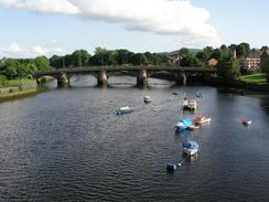
I am quite aware that Glasgow is the only town or city of any size that I will be passing until I reach Fort William, and so it seemed to be wise to go into the centre and get some bits and bobs. In particular I was after a new pair of boots and trainers, both of which should see me through to the end of the journey. My boots have quite a bit of life left in them, but I thought that I could guarantee finding a pair in Glasgow. We therefore caught the train into Glasgow, and after trying four shops we finally found NevisSport, which had the correct boots, but not in the right size. A quick call to their Fort William branch showed that they had some, so I shall pick them up when I reach the town in a month or so. In the meantime I bought a pair of Saloman Flagstaff trainers. I have never really been into Glasgow before (my only trip into the centre being one to find a pub whilst I waited for a train at Queen Street Station), and I was pleasantly surprised by the broad streets and attractive stone buildings, which was not exactly what I had been expecting.
This evening I went down to the local pub, The Waverley, so that I could have a drink and use their facilities. As soon as I stepped out of the van I had trouble walking, with my right ankle aching whenever I put weight on it. I hobbled down to the pub, with the pain getting increasingly worse with every step I took. I am unsure about what the problem is, but it is most certainly not related to when I twisted my ankle a few weeks ago. I think that as I have been wearing my trainers a lot recently it has been putting extra strain on my right ankle on rough ground. I shall see how it feels in the morning before I decided what course of action I need to take about it. When I got to the pub it had the England football match on, so I could not really concentrate on the book I was reading. My ankle was also throbbing, so after half an hour I drunk up my pint and hobbled back to the van. Fortunately my ankle was freer, although it still ached whenever I put weight onto it.
Directions
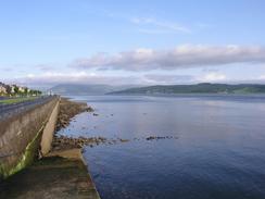
This walk starts off on the promenade beside the Firth of Clyde at Fort Matilda, between Gourack and Greenock. Follow the promenade southeastwards towards some docks, and when it ends near the docks and an observation tower join the adjacent road and follow this as it turns to the right to join the A770 road. Turn left and follow the A770 under an old railway bridge and on past a container terminal. Near a supermarket on the right a cycle path (route 75), head off to the left, going through an old dockland area and past a newly developed waterfront area, before it reaches some docks and heads back to the A8 road.
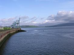
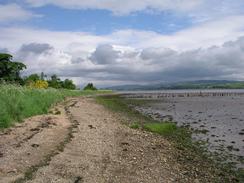
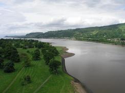
Head eastwards along the A8 road, passing a series of docks and then a large BAE shipyard, as the road enters Port Glasgow. When Newark Castle is reached turn to the left to head towards the castle, where a footpath begins. At the castle turn to the right and follow a footpath that runs eastwards along the river; at times it is so near to the road that it is suspended above the river slightly on a wooden causeway. The path passes a car park and then continues on eastwards past Parklea. When the path turns to the right to join the A8 in Finlaystone continue on and walk along the foreshore; if the tide is high then you will have to follow the footpath over the railway line and to the A8 road, as the foreshore will be impassable.
Continue along the foreshore carefully - it is muddy in places and rocky in others, but progress is not massively difficult, until the A8 road is reached. Climb up the bank onto the A8 and turn left to follow it eastwards for a few yards until a slip road is reached on the other side of the road. Carefully cross the dual carriageway and then follow the slip road, which soon becomes the B789 road, which can be followed eastward through Langbank. Pass the entrance to a roundabout on the A8(T), and continue along the B789 road until it turns sharply to the right to pass under a railway bridge. At the bend a footpath continues straight on, and heads eastwards alongside the A8(T) for about a kilometre until it descends to join a roundabout beneath the start of the M8.
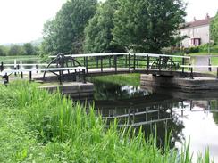
Turn right and head along the A8, which immediately passes under a railway line before heading uphill. Continue along the A8 for a couple of miles into Bishopton, and then turn to the left along the B815 road. Follow this road as it heads northeastwards until it passes over the M8 road, where it curves to head eastwards past Bishopton Church and ends at a roundabout with the A898(T) road by a hospital. At the roundabout continue straight on and then take a path that heads off to the left and climbs up to join the southern end of the Erskine Bridge. Walk over the Erskine Bridge, and on the northern side drop down and turn to the left to head back towards the railway station. Climb over the railway station footbridge and then follow a road until a T-junction with the A814 road is reached. Turn left along this road and just before the Erskine bridge is reached turn to the right to head down a path that leads to a lock on the Forth-Clyde canal.
Cross the canal at the lock and on the other side turn right to follow the canal westwards. This is also cycle route 7, which is followed to the end of the walk. At the end of the canal the cycle route joins an old railway line, which forms a lovely route westwards into Dumbarton. This walk ends by Dalreach Station, just on the western side of Dumbarton.
Distances
| From | To | Distance (m) | Ascent (ft) | Descent (ft) |
|---|---|---|---|---|
| Fort Matilda | Langbank | 9.0 | 295 | 279 |
| Langbank | Kilpatrick | 6.2 | 404 | 338 |
| Kilpatrick | Dalreach | 5.9 | 210 | 256 |
This makes a total distance of 21.1 miles, with 909 feet of ascent and 873 feet of descent.
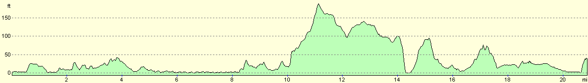
For more information on profiles, ascents and descents, see this page
Accommodation
We parked Mervan on a quiet residential side-street in Dalreach, was good enough for us for the night, and had a pub a handy staggering distance downhill.
Disclaimer
Please note that I take no responsibility for anything that may happen when following these directions. If you intend to follow this route, then please use the relevant maps and check the route out before you go out. As always when walking, use common sense and you should be fine.
If you find any information on any of these routes that is inaccurate, or you wish to add anything, then please email me.
All images on this site are © of the author. Any reproduction, retransmissions, or republication of all or part of any document found on this site is expressly prohibited, unless the author has explicitly granted its prior written consent to so reproduce, retransmit, or republish the material. All other rights reserved.
Although this site includes links providing convenient direct access to other Internet sites, I do not endorse, approve, certify or make warranties or representations as to the accuracy of the information on these sites.
And finally, enjoy your walking!
This walk was mentioned in the following routes:
| My walk around the coastline of Britain |
Nearby walks
| # | Title | Walk length (miles) |
|---|---|---|
| 459 | Fairlie to Fort Matilda | 19.1 |
| 461 | Dalreach to Rosneath | 22.2 |
| 462 | Rosneath to Ardgartan | 26.5 |
|
|

|