Walk #425: Thornton to Cockerham Marsh
 |
 |
|
General Data
| Date Walked | 26/04/2003 |
| County | Lancashire |
| Start Location | Thornton |
| End Location | Cockerham Marsh |
| Start time | 08.40 |
| End time | 16.00 |
| Distance | 18.1 miles |
| Description | This was quite an enjoyable little walk up and down the River Wyre, and then eastwards along the coast. |
| Pack | Today I carried my 30-litre Karrimor HotRock rucksack, which was filled with my packed lunch, waterproof leggings, water bottle and a couple of spare shirts, together with the usual assortment of odds and ends. |
| Condition | I am more or less okay after this walk, except for a little more trouble with my right ankle. This was not as annoying as it had been yesterday, but it was bothersome enough as it was. Aside from this I was fine, and I could easily have walked further. |
| Weather | This was definitely a day of sunshine and showers, although fortunately there was more sunshine and showers. The showers that there were did not get me very wet, and the wind and sun dried me out quickly once the rain had stopped. Fortunately I missed the worst shower, a heavy one that stared a few minutes after I ended the walk. |
| OS map | Landranger number 102 (Preston & Blackpool, Lytham St Anne's) |
 |
 |
|
 |
 |
|
Map of the walk
Maps courtesy of Google Maps. Route for indicative purposes only, and may have been plotted after the walk. Please let me have comments on what you think of this new format. For a detailed table of timings for this walk, please see the table file.
 |
Notes
I set off today expecting to get wet, and so I set off well wrapped up against the weather. Fortunately, and not a little surprisingly, it was not raining when Sam drove Mervan back to the place that I ended yesterday's walk, and the sun was even shining. The walk south down the River Wyre was quite enjoyable, and I even found the section past the ICI works to be interesting. After yesterday's rather dismal walk through Blackpool and Fleetwood it was a nice change to be on footpaths and not on promenades through towns.
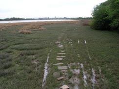
The walk between Skippool and Hambleton was along some very marshy ground. The first stretch to Shard Bridge had stones and bricks thrown in to act as stepping-stones. Unfortunately he majority of these were essentially useless as they were too small, so I ended up just striding through the marshes beside the stones. Near Shard Bridge I passed a man who was using a metal detector on the marshes beside the path. I have no idea what he was looking for, but as I passed he stopped down and started digging a little hole with a trowel. I have seen very few people with metal detectors so far on this walk, which surprises me as I thought that it was quite a popular pastime, and beaches were an ideal place to do it.
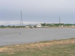
The section of walk from Hackensall Hall to Knott End-on-Sea passed through a golf course. The footpath signs were slightly confusing, so I kept to the edge of sections of the courses as I carefully made my way through. Golf balls were flying everywhere, and I made sure that everyone knew that I was there so the chances of being hit by a ball were reduced. The views to Fleetwood across the mouth of the River Wyre were quite nice, and I think that the town looked better from a distance than it did from close-up.
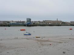
By the time that I reached Knott End-on-Sea I was in need of a rest, so I collapsed into the first pub I came to, the Bourne Arms Hotel. I spent over an hour in the hotel whilst I had a couple of pints and chatted to a few of the locals at the bar. After this I went into the games room at the pub and wrote up the directions for a couple of walks on my Psion. This has helped me catch up (I had been rather slack with the writing of my notes recently), and consequently I believe it was worth taking the hour off the walk.
As I walked along the A588 road I phoned Sam up and asked her to pick me up, and as she came into view it started to rain. We drove into Pilling and parked at a Robinsons pub (which rather to my disappointment did not have any Old Tom) in the village, to wait for the chip shop to open at five. We had a drink and played a couple of games of pool before making our way to the campsite via the chip shop. The campsite is also an Ostrich farm. and we sat in Mervan and watched some ostriches running about as we ate our meal. This was quite an unusual experience, and I really did not expect to eat a meal whilst watching ostriches on this walk!
The forecast for tomorrow is for there to be more rain, and so I will set off in full wet weather again. I will probably get well past Lancaster tomorrow and then down the other side towards Overton. This places me nicely to walk through Morecambe the day after. I am concerned about my right ankle, which gave me trouble again today (although this was not as bad as it was yesterday), and I am hoping that it does not get any worse. I have had the problem since Pembrokeshire, which is a long time to suffer from an injury on a walk like this.
Directions
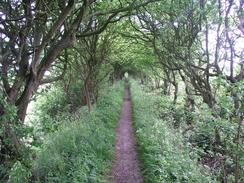
This walk starts off at a bend in the B5268 road, about a kilometre southeast of the junction with the A588(T) road. A footpath (marked as the Wyre Way) heads off to the east past Colchester House, and dives into a nice green footpath with hedges on both sides. The footpath emerges out to cross a railway line before continuing on and meeting a track near the western bank of the River Wyre. When the track is reached turn right and walk southeastwards along the track, which is trapped between the river on the left and an ICI factory on the right. Once the factory is passed the footpath continues on before emerging at a car park for a country park.
Walk through the car park and then join the path one more, which follows a well-made path along the foreshore of the river. I can imagine that at high tides this may be difficult to negotiate. The path follows the river as it curves around before heading southwards past a series of little jetties for sailing boats and reaching a boat club. Join a road that heads south from the club and just before the road reaches the A585(T) a footpath leads off to the right for about a hundred yards before ending at a roundabout on the A585(T). At the roundabout turn left and walk eastwards along the road as it crosses Main Dyke. Pass a petrol station on the right and then turn left down Old Mains Lane, which soon ends and a footpath continues on, crossing marshland before reaching Shard Bridge.
Cross Shard Bridge and once on the north side of the River Wyre turn left to join the foreshore one again. The path curves around following the river before passing some gates leading to Bank Farm and reaching a road. Turn right down this road to the A588 road in Hambleton. Turn left and follow the A588 for a short distance until the Shovels pub is reached on the left. Immediately past the pub turn left down Kiln Lane and follow this lane through the village to a little boatyard. Continue on along the road as it becomes Wardleys Lane and passes the Wardleys pub before heading on for a couple of miles until the road ends at The Heads Caravan Park.
At the end of the road continue straight on down a footpath that follows a flood bank northwards for a mile before ending at a track. Continue straight on along the track as it passes a golf course and skirts around Hackensall Hall. Just past the hall the footpath heads northwestwards through the golf course to meet the riverbank before heading north to end at a road at Knott End-on-Sea. Turn right to walk eastwards along the road for a few hundred metres until it turns to the right. At this point a footpath continues straight on along a flood bank along the river. Follow this footpath for about two and a half miles until it ends at a car park, where you follow a road southeastwards. Between the s6th of December and Good Friday you will have to continue along the lane into Pilling and the head northeastwards to the Lane Ends Amenity Area; otherwise you can head off to the left after about half a mile and reach Pilling Embankment, which can be followed to the Amenity area (this permissive footpath is not marked on Ordnance Survey maps).
Once the Lane Ends Amenity Area is reached head along the road through the park until a road is reached. Turn left down this road for a short distance until the A588 road is reached. Turn left and walk for a couple of miles down the A588 road; this walk ends near the farm at Sand Villa.
Distances
| From | To | Distance (m) | Ascent (ft) | Descent (ft) |
|---|---|---|---|---|
| Thornton | Knott End-on-Sea | 11.6 | 476 | 489 |
| Knott End-on-Sea | A588 road by Cockerham Marsh | 6.5 | 43 | 33 |
This makes a total distance of 18.1 miles, with 519 feet of ascent and 522 feet of descent.
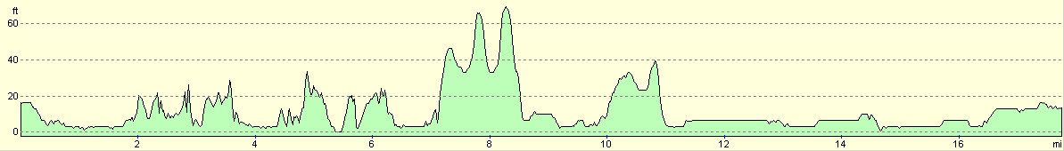
For more information on profiles, ascents and descents, see this page
Accommodation
We spent the night at the campsite owned by Mr and Mrs A Tye, Byrefield Ostrich Farm, Shaws Lane, Pilling, Preston PR3 65A. They can be contacted on (01253) 790473. This side is quite basic and cost us five pound for the night. Whilst it is basic it is quite entertaining, as it is an ostrich farm and we spent the evening watching ostriches in the field next to the van, an experience unique on this walk so far!
Disclaimer
Please note that I take no responsibility for anything that may happen when following these directions. If you intend to follow this route, then please use the relevant maps and check the route out before you go out. As always when walking, use common sense and you should be fine.
If you find any information on any of these routes that is inaccurate, or you wish to add anything, then please email me.
All images on this site are © of the author. Any reproduction, retransmissions, or republication of all or part of any document found on this site is expressly prohibited, unless the author has explicitly granted its prior written consent to so reproduce, retransmit, or republish the material. All other rights reserved.
Although this site includes links providing convenient direct access to other Internet sites, I do not endorse, approve, certify or make warranties or representations as to the accuracy of the information on these sites.
And finally, enjoy your walking!
This walk was mentioned in the following routes:
| My walk around the coastline of Britain |
Nearby walks
| # | Title | Walk length (miles) |
|---|---|---|
| 424 | Lytham St Anne's to Thornton | 17.3 |
| 426 | Cockerham Marsh to Overton | 19.4 |
|
|

|