Walk #426: Cockerham Marsh to Overton
 |
 |
|
General Data
| Date Walked | 27/04/2003 |
| County | Lancashire |
| Start Location | Cockerham Marsh |
| End Location | Overton |
| Start time | 10.33 |
| End time | 17.47 |
| Distance | 19.4 miles |
| Description | This was quite an enjoyable walk, and also one that was quite varied, with a combination of footpath, road and cycle path taking me around the River Lune. |
| Pack | Today I carried my 30-litre Karrimor HotRock rucksack, which was filled with my packed lunch, waterproof leggings, water bottle and a couple of spare shirts, together with the usual assortment of odds and ends. |
| Condition | I feel absolutely fine after this walk, and I could easily have walked further if I had wanted to. The biggest problem that I had was with my right ankle; not from the problem that I have with the left-hand side of it but with the braces, which was digging into my Achilles. |
| Weather | I had been expecting it to be a wet day, but fortunately this did not come to pass. There were a couple of drizzle showers, but aside from this the day was dry. It was quite windy, and this was annoying when I was on exposed sections of coastline. There were some quite prolonged periods of sunshine, and these helped counteract the chill from the wind. |
| OS map | Landranger number 102 (Preston & Blackpool, Lytham St Anne's) and Landranger number 97 (Kendal & Morecambe, Windermere & Lancaster) |
 |
 |
|
 |
 |
|
Map of the walk
Maps courtesy of Google Maps. Route for indicative purposes only, and may have been plotted after the walk. Please let me have comments on what you think of this new format. For a detailed table of timings for this walk, please see the table file.
 |
 |
|
 |
Notes
I set off quite late this morning, as I spent a few hours getting an update ready for my website. This seemed to take an age, but was worth the effort as it is now up to date. I had woken up to the sound of Ostriches, which was a highly unusual sound to wake up to, and also helped to put me out of sorts. By the time that I had burnt the CD with the updates and was ready to leave, I was feeling quite nauseous as a result of getting up early and of having spent hours looking at a computer screen all morning. Fortunately this feeling disappeared within a few minutes of starting the walk, as the fresh air got into my system and I could start focussing on something more than six inches from my nose.
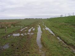
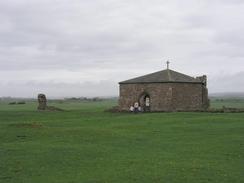
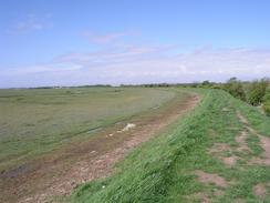
Early on in this walk I passed over some fairly boggy ground, my boots squelching in the mud. My feet did not get wet, but walking through the boggy patches was not exactly my idea of fun, so I ended up walking along the side of the flood bank instead, which was an easier route. Fairly early on I passed the remains of Cockersand Abbey, the largest remaining part of which is a little chapel. In the sixteenth century this was one of the richest religious houses in Lancashire, with an annual income of three hundred pound. It is quite an exposed location and the wind was blowing wildly around me as I walked around the chapel, and I can imagine how cold it must have been to live there in really bad weather.
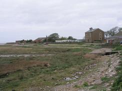
I got a great view of the surrounding area from Tithe Barn Hill above the village of Glasson, and I could see the place where I was due to end the walk on the other bank of the River Lune. Glasson itself as quite a nice little village, and I enjoyed looking at the boats in the dock, which was opened in 1783 and was the first dock in England to be fitted with gates to maintain the water level at high tide. From Glasson I followed an old railway trackbed virtually all the way into Lancaster, which allowed me to get a good speed up as the going was very easy.
I met Sam by the railway bridge over the river on the western outskirts of Lancaster. I used this opportunity to eat my lunch, and we chatted about the latest gossip from Cambridge about friends of ours. I had been intending to use the pedestrian footbridge beside the rail bridge to cross over to the northern bank of the River Lune, but this was shut off fore repairs and so I was forced to walk a few hundred yards upstream to the next crossing point a new pedestrian and cycle bridge over the river. Lancaster looked quite pretty, and although I did not go into the centre of the town I cold just see part of the castle and the areas that I did pas through were nice.
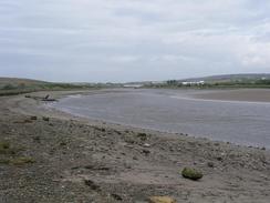
When I reached Overton I was in two minds about whether to stop at Mervan (which was parked near the centre of the village) or to do the little loop around the bottom of the village via Bazil Point. I decided to do the walk, and whilst this was a good decision I wish that I had changed from my trainers into my boots. The track that led down to Bazil Point was good, but from there it went along the foreshore to the tidal road at the western side of the village, and this was very boggy. Although I did not get my feet wet I had to divert into a field around the worst section, and my trainers were very muddy at the end.
The first part of tomorrows walk is along the tidal road south from Overton to Sunderland. I am hoping that the tide will not be high and that I can walk along this road; otherwise I shall have to take a diversion around this section on a footpath further inland. After this I shall be making a diversion around the nuclear power stations at Heysham before heading north to Morecambe and Carnforth.
Directions
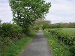
This walk starts off beside Sand Villa, on the A588 road between Pilling and Cockerham. Follow the A588 road northeastwards for a mile until it reaches a bridge over the River Cocker. Cross the bridge and on the other side turn left to take a footpath that heads northwards beside a flood bank to a car park near Pattys Farm, from where a track continues on to end at a road. Turn left along this road and follow it westwards to Bank End Farm, where the road ends and a footpath continues on past Bank Houses, where it turns to the right and continues on past Cockersand Abbey Farm and the remains of Cockersand Abbey itself. The path then joins a flood bank which heads northeastwards to lighthouse cottage, although I could see no traces of a lighthouse anywhere. At the cottage the path joins a track that head northwards towards Crook Farm, immediately before which a footpath joins off to the right along a track. The track soon ends and a footpath continues on northeastwards, crossing a stream before joining another track and following it until it ends at a road. Turn left and head northwards a short distance to the viewpoint on Tithe Barn Hill, where another road junction is reached. Turn right along this road and follow it downhill into the bridge over a canal in the village of Glasson.
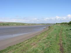
Cross over the canal and continue on for a few yards until the road ends at a T-junction with the B5290 road. Turn right along the road for a short distance past a little car park, where a path leads off to the left to the old railway trackbed. A cycle path heads eastwards along the old trackbed, and this can be followed as it curves around and crosses the River Conder before heading in a northerly direction. The cycle path heads underneath two sets of power lines and shortly afterwards it reaches a car park. At the car park a footpath heads off to the left to reach a flood bank beside the river. Head along this flood bank as it heads northwestwards and then northeastwards for almost two miles, before eventually meeting a road that can be followed eastwards into Lancaster.
On the western outskirts of Lancaster a rail bridge is reached, and beside this there is a pedestrian bridge that can be used to cross the river (when I did this walk this footbridge was closed; an alternative footbridge is available a few hundred yards upstream). On the northern bank of the river drop down to a cycle path that can be followed westwards for a little over a kilometre until a supermarket is reached on the left just before the B5273 road is reached. Head through the car park of the supermarket and join the B5273 road, and turn left to head down the road until a roundabout is reached. A the roundabout take the first exit and follow the road along a flood plain, passing Oxcliffe Hill and a pub (this road is tidal and can flood) until it eventually climbs up and ends at a T-junction with another road. Turn left down this road and follow it southwards until it curves around to the right, and at this bend continue on down another road.
This road continues southwards for a couple of hundred yards before curving to the right and heading uphill to end at a T-junction with another road. Turn left and head south down this road. It passes under another couple of power lines and continues due south into the village of Overton. At a road junction in the centre of the village turn left down a road for a hundred yards, and follow it as it curves sharply to the right to head southwards towards the river. When the road ends continue on along a track that soon becomes a footpath that leads to Bazil Point. The footpath curves around Bazil Point along the foreshore (which is very boggy in places) and then heads north, before curving northwestwards and ending at a tidal road to the west of the village. This walk ends about fifty yards to the right, at the Globe Hotel.
Distances
| From | To | Distance (m) | Ascent (ft) | Descent (ft) |
|---|---|---|---|---|
| A588 road by Cockerham Marsh | Glasson | 6.5 | 131 | 141 |
| Glasson | Lancaster | 6.0 | 184 | 187 |
| Lancaster | Overton | 6.9 | 289 | 276 |
This makes a total distance of 19.4 miles, with 604 feet of ascent and 604 feet of descent.
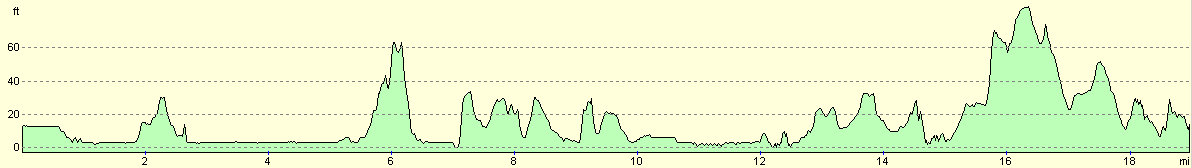
For more information on profiles, ascents and descents, see this page
Accommodation
We parked Mervan for the night in the car park opposite The Globe pub. This was a reasonable place to park for the night, and was vry handy for the pub.
Disclaimer
Please note that I take no responsibility for anything that may happen when following these directions. If you intend to follow this route, then please use the relevant maps and check the route out before you go out. As always when walking, use common sense and you should be fine.
If you find any information on any of these routes that is inaccurate, or you wish to add anything, then please email me.
All images on this site are © of the author. Any reproduction, retransmissions, or republication of all or part of any document found on this site is expressly prohibited, unless the author has explicitly granted its prior written consent to so reproduce, retransmit, or republish the material. All other rights reserved.
Although this site includes links providing convenient direct access to other Internet sites, I do not endorse, approve, certify or make warranties or representations as to the accuracy of the information on these sites.
And finally, enjoy your walking!
This walk was mentioned in the following routes:
| My walk around the coastline of Britain |
Nearby walks
| # | Title | Walk length (miles) |
|---|---|---|
| 425 | Thornton to Cockerham Marsh | 18.1 |
|
|

|