Walk #459: Fairlie to Fort Matilda
 |
 |
|
General Data
| Date Walked | 01/06/2003 |
| County | Strathclyde |
| Start Location | Fairlie |
| End Location | Fort Matilda |
| Start time | 09.57 |
| End time | 17.20 |
| Distance | 19.1 miles |
| Description | This was a surprisingly enjoyable walk, and one that was quite uplifting after yesterday's depressing walk. |
| Pack | Today I carried my 30-litre Karrimor HotRock rucksack, which was filled with my packed lunch, waterproof leggings, water bottle and a couple of spare shirts, together with the usual assortment of odds and ends. |
| Condition | I have suffered a couple of little problems today, the worst of which is probably a pulled hamstring in my left leg that I felt go as I was walking along a section of road. This was not a major problem, but it feels slightly sore tonight. Aside from this I had early problems with me left ankle, which was aching for he first few miles but which thankfully freed up for the rest of the walk. |
| Weather | Today was another mixed-up day, with long periods of sunshine, lots of cloud and a few minutes worth of light drizzle. It was not as hot as it has been over the last couple of days, and I was quite thankful about that. |
| OS map | Landranger number 63 (Firth Of Clyde area) |
 |
 |
|
 |
 |
|
Map of the walk
Maps courtesy of Google Maps. Route for indicative purposes only, and may have been plotted after the walk. Please let me have comments on what you think of this new format. For a detailed table of timings for this walk, please see the table file.
 |
 |
|
Notes
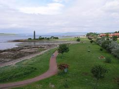
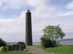
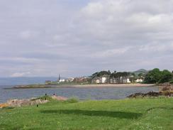
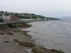
I started off by walking along the A78(T) road towards Largs, which I found to be surprisingly busy for a Sunday morning. At the earliest possible opportunity I crosses over the railway line and went past the marina to reach a large tower (the Pencil Monument) that commemorates the Battle of Largs in 1263. From here there was a much more pleasant walk along the seafront into Large, which I found to be quite a pleasant town. I watched the ferry come in from Great Cumbrae Island, disgorge its load of cars and people and take on a new load, mainly of brownies travelling to the island. Work on a flood defence scheme for the town was near completion, and I enjoyed looking at the workers working as I passed.
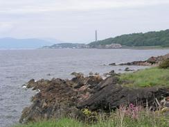
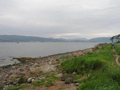
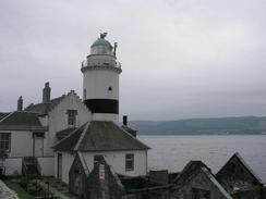
It is a strange thing to admit, but this afternoon for the first time since re-entering the country I really felt like I was in Scotland. I have been in the country for the last couple of weeks, but it was only today when I got my first good view of sea lochs and mountains that I really felt like I was in Scotland. The views of the sea lochs glistening in the sunshine, with the backdrop of the distant hills were quite stunning at times, and made the long walk along the road quite bearable. Indeed once the A78(T) ended and I joined the A770 the road was much quieter and there was a pavement, so I could really enjoy the stroll. I passed the lighthouse at Cloch Point, which is not the most impressive lighthouse that I have passed on the journey, and is rather spoilt by the buildings immediately around it. This lighthouse was built in 1791 and it is 76 feet high.
I could see Dunoon for much of the afternoon, and it strange to think that I have many days - maybe as many as six - to walk before I get there. Seeing it a couple of miles away across the Firth of Forth was quite tantalising, and not for the first time on this trip I wished that I was taking ferries across rivers. I watched the ferries depart regularly to and from Dunoon as I walked, and I wondered about how a place so near could be in reality so far away, all as a result of a decision I made before the walk started. On the other hand it does mean that I will be seeing some exceedingly scenic areas of Scotland, so it is not all negative.
Shortly before I topped for lunch I suddenly felt a large ping in my left thigh as a couple of strand of muscles went in my hamstring. I stopped for a minute and gave it a massage, which seemed to help it. I have had this happen before on a previous trip (although that time it was in my left calf), so the feel of a pinging muscle was somewhat familiar. I walked on, but I was quite relieved to find a restaurant and bar, called The Chartroom, at the marina in Inverkip. It looked quite posh and so I enquired if this slightly mucky walker could come in, and the agreed, so I sat down at a table and had a pint, wrote some notes and massaged my left hamstring. Once I left the pub I walked quite gingerly for a bit, and although the hamstring was slightly sore it was not giving me any great problems.
Tomorrow I will be heading towards Glasgow so that I can cross the Firth of Clyde on the Erskine Bridge. Hopefully I will be able to reach there quite quickly (it should be about fifteen miles from here at a rough guess), and cross over onto the other side. Unfortunately to get to the Erskine Bridge the route takes me mainly along main roads, and finally the M8, so I shall have to divert inland around that. It is not going to be a very nice stretch of walk, and so I shall be glad when it is over. Once on the other side of the bridge, however, I should be quite happy, as it means that the last big barrier to reaching the really scenic section of Scotland has been crossed, and I shall be starting to enter the more remote and beautiful areas. This is something that I am both looking forward to, and also slightly nervous about, but the latter emotion should make the former much more enjoyable and fulfilling.
Directions
This walk starts off on the A78(T) road beside the church in the village of Fairlie. Head north along the A78(T) for a little over a mile, with the railway line to the left. It passes the entrance to Kelburn Country Centre on the right and a marina on the left, and at the northern end of the marina turn left along the entrance to the marina, which climbs over the railway on a bridge before descending and continuing on to the large monument commemorating the Battle of Large.
Turn right and walk along a path that heads northwestwards beside the sea through the southern outskirts of Largs. The path eventually becomes a promenade that passes right through the centre of the town and passes the pier and continues on northwards past Largs Bay. At the lifeboat station I left the promenade and joined the A78(T) road, which I followed northwards out of the town. The pavement soon ends and the road is narrow as it heads northwards beside the sea, so care is needed on this stretch of the walk.
The road crosses Skelmorie Water, which empties into Meigle Bay, and then a pavement starts on the right, and this made the walk much safer and enjoyable. The road passes through Skelmorie and then Weymyss Bay, passing under a railway line and continuing on northwards. The pavement ends near Inverkip power station, so descend down the slip road that leads to the power station and up the other slip road to rejoin the A78(T), where the pavement restarts. Pass a car park and a memorial as the road turns to head northeastwards, and then pass Inverkip Marina. Turn left to head up the entrance road to the marina and then follow the road as it swings to the right to cross a stream.
Here my directions are slightly difficult; a new housing estate is being built in the area and it is changing rapidly, so you may need to direct yourself to get to the sea. Just before you reach the Chartroom restaurant turn right down a track, which head around and passes a little building before entering a wooded area and reaching the little beach just to the south of Ardgowan Point. Turn right and head along a path that heads alongside the sea, before leaving the forest and heading around Lunderston Bay, at the northern end of which is a car park. Continue on along the path until it ends at the A770 road.
Head north along the A770 as it passes the lighthouse at Cloch Point, where it turns to the right to head in a more easterly direction towards McInroy's Point. Stay on the A770 road as it passes through Gourack and reaches Kempock Point, where the road turns to head around Gourack Bay. The road passes a little park on the left and a large complex of coastguard stations, and after these turn to the left down a road that heads for a short distance to the sea at Fort Matilda. The road swings to the right and his walk end a few hundred yards down this road, near an old floating light buoy on the promenade.
Distances
| From | To | Distance (m) | Ascent (ft) | Descent (ft) |
|---|---|---|---|---|
| Fairlie | Skelmorie | 8.1 | 253 | 266 |
| Skelmorie | Fort Matilda | 11.0 | 673 | 709 |
This makes a total distance of 19.1 miles, with 926 feet of ascent and 975 feet of descent.
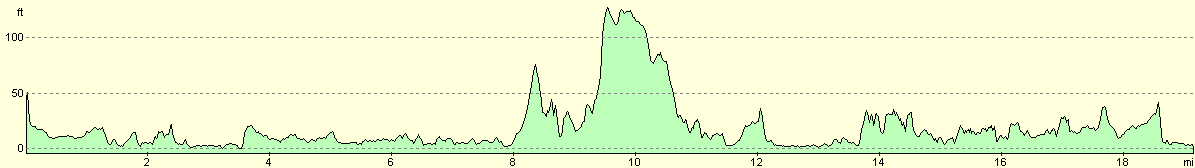
For more information on profiles, ascents and descents, see this page
Accommodation
We parked Mervan by the Esplanade in the outskirts of Greenock, just to the southeast of Fort Matilda. This was quite a quiet road, with some lovely views available over the Firth of Clyde towards Kilcreggan and Helensburgh.
Disclaimer
Please note that I take no responsibility for anything that may happen when following these directions. If you intend to follow this route, then please use the relevant maps and check the route out before you go out. As always when walking, use common sense and you should be fine.
If you find any information on any of these routes that is inaccurate, or you wish to add anything, then please email me.
All images on this site are © of the author. Any reproduction, retransmissions, or republication of all or part of any document found on this site is expressly prohibited, unless the author has explicitly granted its prior written consent to so reproduce, retransmit, or republish the material. All other rights reserved.
Although this site includes links providing convenient direct access to other Internet sites, I do not endorse, approve, certify or make warranties or representations as to the accuracy of the information on these sites.
And finally, enjoy your walking!
This walk was mentioned in the following routes:
| My walk around the coastline of Britain |
Nearby walks
| # | Title | Walk length (miles) |
|---|---|---|
| 458 | Irvine to Fairlie | 18.6 |
| 460 | Fort Matilda to Dalreach | 21.1 |
| 461 | Dalreach to Rosneath | 22.2 |
|
|

|