Walk #458: Irvine to Fairlie
 |
 |
|
General Data
| Date Walked | 31/05/2003 |
| County | Strathclyde |
| Start Location | Irvine |
| End Location | Fairlie |
| Start time | 10.07 |
| End time | 17.20 |
| Distance | 18.6 miles |
| Description | This was a fairly entertaining if nondescript walk northwards along the coast. |
| Pack | Today I carried my 30-litre Karrimor HotRock rucksack, which was filled with my packed lunch, waterproof leggings, water bottle and a couple of spare shirts, together with the usual assortment of odds and ends. |
| Condition | I feel absolutely fine after this walk, and I have no problems to report. My left ankle ached when I tripped slightly, but this was more annoying than anything else. |
| Weather | Today's weather was quite nice, with some high temperatures (although it was not as warm as yesterday), and it remained dry all day. Unfortunately the skies were often overcast, and when it was not overcast the sun was only visible through a haze, and so the risk of getting sunburnt was quite low. |
| OS map | Landranger number 70 (Ayr, Kilmarnock & Troon) and Landranger number 63 (Firth Of Clyde area) |
 |
 |
|
 |
 |
|
Map of the walk
Maps courtesy of Google Maps. Route for indicative purposes only, and may have been plotted after the walk. Please let me have comments on what you think of this new format. For a detailed table of timings for this walk, please see the table file.
 |
 |
|
Notes
Sam had arranged for me to have an interview with a journalist from a local paper first thing this morning, so we got all my gear ready to go before she arrived. We did quite a long interview and we then waited for a photographer to turn up. Eventually she said that she would go and fetch him and that she would be ten minutes, before zooming off in her car. I waited for about an hour but they still had not come back and no-one was answering the phone, so I reluctantly set off. The delay annoyed me, and unfortunately this set the tone for the day.
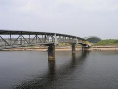
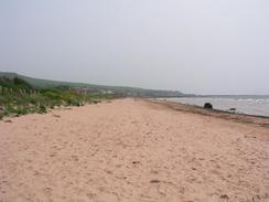
On a more positive note that bridge leading over the River Garnock was open, so I could use it to cross the river and avoid having to make the long and boring diversion inland. I then made my way to the long stretch of beach that head northwestwards towards Saltcoats, and after a few hundred yards I could se a figure in the distance, walking in the same direction as me. As I got closer I could see that he was totally nude, with nothing covering him except for a mane of short grey hair. I passed him as he was wading through the breakers, and we explained pleasantries as I walked on, passing several more nudists later on. Although I have passed through several nudist beaches on the trip, this was the first nudist that I had seen (probably due to the fact that much of the walk has been in winter and spring).
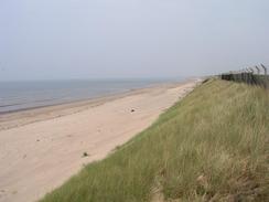
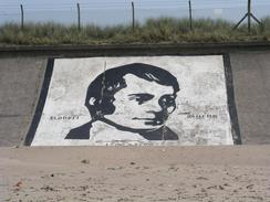
The beach passes an old explosives works that was originally built by Alfred Nobel (apparently some of which is still in use), and so until the bridge over the River Garnock was built a couple of years ago the beach was virtually inaccessible. An old sea wall protected much of the area behind the beach, and near the northern end of the beach there was a nice black and white painting of Robert Burns - a very strange place for it to be.
I wore my Tilley hat for the first time on the walk today, as the top of my head caught the sun slightly yesterday. This worked quite well, although at times my head became rather too hot and at times I wished that I did not have it on. It is quite strange to have got out this hat for the first time on the trip, as before I have always worn woolly hats to keep me warm, rather than hats to keep me cool! The Tilley hat is also rather good at keeping my head dry when it is raining, so I can imagine now that I have got it out I shall use it for that purpose as well.
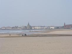
As I reached Seamill I was in need of a rest, and so I decided to nip into the Waterside Inn, which is beside the sea to the south of the town. They had Abbott on tap, so I had a pint of that and sat down to write up some notes on my Psion. That had been my intention, but I ended up spending most of my time having a very pleasant chat to a few people in the pub, all of whom kindly gave me a donation. After the little period of unpleasantness in Ayr the other night, it is nice finding people who are kind and generous.
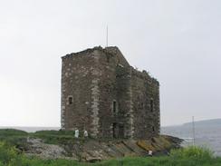
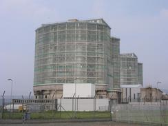
At Farland Head I reached the ruins of Portencross Castle. These impressive ruins are reputed to be the last resting place on the mainland of former Scottish kings from Kenneth MacAlpine to Malcolm Canmore before they were taken over to Iona for burial. The castle was built sometime between 1371 and 1390 (during the reign of Robert II), and the roof blew of it during a great storm in 1739. The ruins of the castle are quite impressive, and a group are trying to raise funds to maintain the structure and to open it to public access. A little further on I came to a set of more modern structures, in the form of the Hunterston 'A' and 'B' nuclear power stations. The A station mainly consists of two steel, glass and concrete buildings that, although not beautiful, are not as unsightly as some nuclear power stations that I have seen.
By the time I was approaching the southern outskirts of Fairlie I started to realise that if I walked on to Largs, where I had been planning to finish, it would be another hour, and as we had a campsite that would eat away at the time that I could be doing some work. For this reason I gave Sam a phone, and we arranged to meet at Fairlie Church. The timing was quite good, as she arrived exactly as I did, and I bundled into the van ready for the drive to the campsite.
Directions
This walk starts off at the car park on the southern side of the south of the River Garnock, to the southwest of Irvine. Head upstream for a few hundred yards through the car park until the pedestrian footbridge over the river is reached. This bridge is only open between nine and five on weekdays, and nine and six at weekends. Once on the other side of the bridge turn left to walk past the Big Idea southwestwards through the sand dunes until the beach is reached. Turn right to walk northwestwards along the beach for a few miles until a little peninsular is reached. Cross this little peninsular and then walk along the beach towards Saltcoats - there is a little stream to be crossed, and there is a bridge over it at the end of the car park a few yards inland
Continue along the beach, and when it ends climb up a ramp and join the top of a seawall that heads westwards beside the railway line. When this meets the B714 road turn left and follow the promenade beside the road all the way around the coastline of Saltcoats. The promenade heads around South Bay before meeting the A738 road, which can be followed past Ardrossan Town railway station, and when the road shortly ends at a railway station continue straight on along a minor road, which soon turns to the right to head northwards past the pier. Continue along this road as it curves to the left to join the A78(T) road.
Follow the A78(T) northwestwards for three miles, passing through Seamill. Shortly after the Seamill Hydro complex is passed on the left turn left down a road that leads to the beach. Head northwestwards along the beach, and when a path starts on the right between the golf course and the sea join this and follow it past Ardneil Bay. Shortly past Mhor the path curves to the right and heads north for about a hundred yards until it meets the B7048 road. Turn left to head westwards along the B7048 road past Farland Head until a car park is reached beside Portencross Castle.
A path then heads northwards, passing the castle and the pier before continuing on past fields and joining a road that heads past the Hunterston nuclear power stations. Continue on along the road as it passes the 'A' and 'B' stations and then curves to the right past Inner Brigurd Point to head eastwards for a little under two miles until it ends at a roundabout with the A78(T) road. At the roundabout turn left to head northwards along the A78(T), passing the coal terminal and on into Fairlie. There is a pavement all the way along this stretch of road, so it is perfectly safe. On the southern outskirts of Fairlie turn left to enter a car park that leads to a path hat heads north beside the sea through Fairlie. When this path ends turn right up a road to rejoin the A78(T). This road ends about half a kilometre further north, beside Fairlie church.
Distances
| From | To | Distance (m) | Ascent (ft) | Descent (ft) |
|---|---|---|---|---|
| Irvine | Ardrossan | 6.4 | 187 | 194 |
| Ardrossan | Seamill | 4.1 | 85 | 72 |
| Seamill | Fairlie | 8.1 | 335 | 302 |
This makes a total distance of 18.6 miles, with 607 feet of ascent and 568 feet of descent.

For more information on profiles, ascents and descents, see this page
Accommodation
We spent the night at the Mains Caravan Park, Skelmorie, Ayrshire PA17 5EU. They kindly knocked five pounds off the price of the site, which meant that it cost six pounds for the night. They an be contacted on (01475) 520794.
Disclaimer
Please note that I take no responsibility for anything that may happen when following these directions. If you intend to follow this route, then please use the relevant maps and check the route out before you go out. As always when walking, use common sense and you should be fine.
If you find any information on any of these routes that is inaccurate, or you wish to add anything, then please email me.
All images on this site are © of the author. Any reproduction, retransmissions, or republication of all or part of any document found on this site is expressly prohibited, unless the author has explicitly granted its prior written consent to so reproduce, retransmit, or republish the material. All other rights reserved.
Although this site includes links providing convenient direct access to other Internet sites, I do not endorse, approve, certify or make warranties or representations as to the accuracy of the information on these sites.
And finally, enjoy your walking!
This walk was mentioned in the following routes:
| My walk around the coastline of Britain |
Nearby walks
| # | Title | Walk length (miles) |
|---|---|---|
| 457 | Electric Brae to Irvine | 25.5 |
|
|

|