Walk #462: Rosneath to Ardgartan
 |
 |
|
General Data
| Date Walked | 04/06/2003 |
| County | Strathclyde |
| Start Location | Rosneath |
| End Location | Ardgartan |
| Start time | 08.12 |
| End time | 17.23 |
| Distance | 26.5 miles |
| Description | This was an exceedingly long day, the majority of which was along roads, but one with lots of views available over all the sea lochs. |
| Pack | Today I carried my 30-litre Karrimor HotRock rucksack, which was filled with my packed lunch, waterproof leggings, water bottle and a couple of spare shirts, together with the usual assortment of odds and ends. |
| Condition | I am quite fatigued after this trip, which is only to be expected after such a long day, but otherwise I feel absolutely fine. I did not have any trouble at all with my feet, ankles or legs, so all in all I am exceedingly happy. |
| Weather | The weather today was very mixed, with some sunny periods, but also a couple of hours of unbroken, light rain. It was quite warm, however, and there was not much wind so I really did not mind the rain too much. |
| OS map | Landranger number 63 (Firth Of Clyde area) and Landranger number 56 (Loch Lomond & Inveraray) |
 |
 |
|
 |
 |
|
Map of the walk
Maps courtesy of Google Maps. Route for indicative purposes only, and may have been plotted after the walk. Please let me have comments on what you think of this new format. For a detailed table of timings for this walk, please see the table file.
 |
Notes
This was an exceptionally long walk for me - not only was it the longest day of the trip so far, it was also my first marathon day (so called because it was a greater distance than a marathon). Despite the length of the walk I feel quite fine, and after a little rest and a shower felt fighting fit once more. The distances that I have been doing recently are far grater than I had been planning, but I am not pushing myself too much and I am enjoying the long days, which is all that I can ask really.
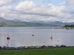
The first part of the walk south to Kilcreggan was very enjoyable. I chose to avoid walking along the road and instead follow paths through woodland towards Rosneath Point, through which there were lots of black rabbits running happily about. This was much a much less direct route, but far more enjoyable, than the road route. When I reached Kilcreggan I went into a coupler of the shops and chatted to the locals, which wasted some time but was quite enjoyable. The town itself was quite nice, and I enjoyed watching a ferry come over from Greenock and disgorge its passengers onto dry land.
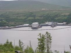
I had noticed from John Merrill's book that in 1977 he walked northwards cross the hills from Coulport, where there is now a large Royal Nay armaments depot. I was fairly keen to do this as it was a far better route than the road alternative, but as I approached Coulport I did not know if I could do or not. As I passed the Faslane base yesterday I had noticed signs that showed a large area of land above Coulport as being prohibited MOD land (as part of the armaments depot), and so I guessed that access would not be allowed. As I approached the roundabout on the B833 to the south of Coulport I could see policemen at a gate house, and I decided that it was not even worth asking if access was possible, so I turned to the right to walk uphill along the road. It could be that when John Merrill did the walk in 1977 the land was accessible, and that it has since been shut off. As I walked along the road I got some lovely views down the southern part of Loch Long, and I could see a submarine slowly moving down the loch. Shortly after this a couple of policemen passed me on four wheel dune buggies - it must be a great job patrolling the land on those vehicles!
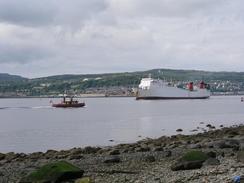
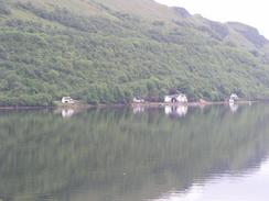
I met Sam in a little car park and viewpoint on the B872 to the north of Garelochhead, and I sat in Mervan to have a rest and eat my sandwiches. I had already walked for over fifteen miles, and I knew that I had nearly nine to walk to reach Arrochar at the northern end of the loch. I still felt fine, however, and despite the rain that had started falling I still felt confident about the rest of the walk. The walk along the A814 was a long plod, although there were occasional views across the loch, and there was even the sight of a large Royal Navy warship (the Fort Austin) being replenished at a jetty - a very incongruous sight as it is seemingly in the middle of nowhere. The Fort Austin is quite a large ship, and I enjoyed studying it as I walked past. A little further on I came across a car crash in the middle of the road - the driver had apparently swerved to avoid a sheep and went into the barriers at the side of the road. I chatted to one of the policemen and he kindly gave me a small donation towards the charity. A little later on I started getting a little bored, and as the road was fairly quiet I phone up a few friends and chatted away to them on the phone - some I had not talked to for some time, and hearing their voices filled me with pangs of guilt about how the walk has caused me to neglect some old friendships.
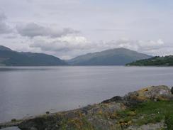
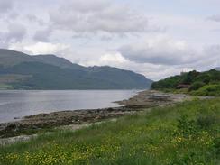
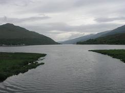
Loch Long more than lives up to its name - I walked from its southern tip to the northern end today, and it has taken me into totally different scenery. The southern end has lovely views over the Firth of Clyde, whilst the northern end is embedded in the Arrochar Alps. I could even see the Cobbler a short distance to the west of the loch, and it looked like a very tempting walk. Another thing that surprised me is how far north I am - Arrochar is quite near to Loch Lomond, and Fort William would only be three or four days walks away along the West Highland Way. Instead, to reach Fort William along the coast is going to take another three weeks, which shows exactly how many lochs I have to walk around to get there.
Fortunately I have an easier day planned for tomorrow - I have to walk around the Ardgartan peninsular, which is all forested. I was 8unsure about how to get around the very southern tip of the peninsular as the forestry tracks do not join, and so this afternoon Sam went to a local visitors centre and found out that there are no paths to do this, but that there is a cycle path through the forest. Although this does not visit the very southern tip of the peninsular I think that I shall use this - the southern end appears to be quite rocky and hard going, so it would be better for me to stick to an acknowledged path. I am quite looking forward to this walk, and hopefully once I have reached Lochgoilhead at the other end I shall be able to walk down to Carrick Castle, and end the day there.
Directions
This walk starts off beside the B833 road in the village of Rosneath. Head south along the road, passing the church and leaving the village as the road follows the side of Rosneath Bay. When the road climbs away from the side of the bay turn left down a surfaced track that heads eastwards through some woodland and heads towards Castle Point. The path enters a caravan park and head through it to the little beacon at Castle Point, and then turns right to head southwards through the caravan park. At the southern end of the park go through a gate near the seashore and follow a broad track through the woodland, passing Robert Ness. At the southern end of Culwatty Bay there is a junction in the track; turn right down a track that heads westwards, just skirting the edge of the forest. Once the path leaves the forest there is a track junction; turn left to head southwestwards down another track that meets the sea at Meikleross Bay.
From here the track skirt the coast westwards until it reaches Portkil Bay, where I joined the foreshore for a short distance until Portkil Point, where I joined a surfaced track that runs westwards before meeting the B833 road on the eastern outskirts of Kilcreggan. Turn left and walk along the B833 through Kilcreggan, after which it turns to the right to head northwards. Continue northwards along the road for about five and a half miles until a roundabout is reached to the southeast of Coulport.
At the roundabout turn to the right along a road that climbs steeply uphill, before turning to the left past Garelochhead forest before descending down to a roundabout with the A814 just to the south of Portincaple. Turn left to head northwards along this road, which descends to meet the eastern bank of Loch Long and then follows this northward for nearly nine miles into the village of Arrochar. Pass the junction with the A83(T) in the village and continue on as the road curves around the top end of the loch and crosses Loin Water, and then head southwards for a couple of miles southwestwards down the A83(T), until Ardgartan campsite is reached on the left, where this walk ends.
Distances
| From | To | Distance (m) | Ascent (ft) | Descent (ft) |
|---|---|---|---|---|
| Rosneath | Kilcreggan | 4.8 | 312 | 338 |
| Kilgreggan | Portincaple | 10.7 | 1214 | 948 |
| Portincaple | Arrochar | 8.0 | 928 | 1184 |
| Arrochar | Ardgartan | 3.0 | 128 | 121 |
This makes a total distance of 26.5 miles, with 2582 feet of ascent and 2591 feet of descent.
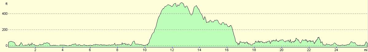
For more information on profiles, ascents and descents, see this page
Accommodation
We stayed at the Forest Holidays, The Forestry Commission, Ardgartan Caravan and Camping site, Arrochar, Argyll G83 7AR. This site was reasonable, and cost us nine pounds and thirty pence for the night. They can be contacted on (0131) 314 6505 or (01301) 702293, and they have a website at www.forestholidays.co.uk.
Disclaimer
Please note that I take no responsibility for anything that may happen when following these directions. If you intend to follow this route, then please use the relevant maps and check the route out before you go out. As always when walking, use common sense and you should be fine.
If you find any information on any of these routes that is inaccurate, or you wish to add anything, then please email me.
All images on this site are © of the author. Any reproduction, retransmissions, or republication of all or part of any document found on this site is expressly prohibited, unless the author has explicitly granted its prior written consent to so reproduce, retransmit, or republish the material. All other rights reserved.
Although this site includes links providing convenient direct access to other Internet sites, I do not endorse, approve, certify or make warranties or representations as to the accuracy of the information on these sites.
And finally, enjoy your walking!
This walk was mentioned in the following routes:
| My walk around the coastline of Britain |
Nearby walks
| # | Title | Walk length (miles) |
|---|---|---|
| 459 | Fairlie to Fort Matilda | 19.1 |
| 460 | Fort Matilda to Dalreach | 21.1 |
| 461 | Dalreach to Rosneath | 22.2 |
|
|

|