Walk #455: Cairnryan to Lendalfoot
 |
 |
|
General Data
| Date Walked | 28/05/2003 |
| County | Dumfries and Galloway, Strathclyde |
| Start Location | Cairnryan |
| End Location | Lendalfoot |
| Start time | 09.32 |
| End time | 16.42 |
| Distance | 20.3 miles |
| Description | This was quite an enjoyable walk, despite the long slog along main roads that I had to endure for much of the day. |
| Pack | Today I carried my 30-litre Karrimor HotRock rucksack, which was filled with my packed lunch, waterproof leggings, water bottle and a couple of spare shirts, together with the usual assortment of odds and ends. |
| Condition | I found it quite hard to get started today after my long day yesterday, and although this did not effect my walking too much it proved to be annoying. The biggest problem that I suffered was a pain in one of the toes of my right foot, a minor problem after such a long walk. |
| Weather | Today was another wet day, but despite the fact that it rained continuously it was not too bad as the rain was light. There was not much wind, and I did see the sun once or twice through the cloud. |
| OS map | Landranger number 82 (Stranraer & Glenluce, The Rhins) and Landranger number 76 (Girvan, Ballantrae & Barrhill) |
 |
 |
|
 |
 |
|
Map of the walk
Maps courtesy of Google Maps. Route for indicative purposes only, and may have been plotted after the walk. Please let me have comments on what you think of this new format. For a detailed table of timings for this walk, please see the table file.
Notes
I had been expecting today to be a long and boring plod along a busy main road, but it did not turn out to be that bad. I did not start off walking as fast as I did yesterday as my limbs were aching after yesterday's exertions.
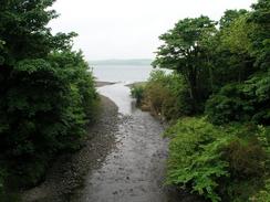
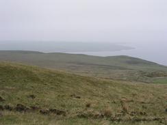
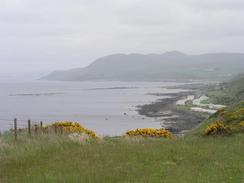
At Finnarts Bay I left the main road and diverted along racks past Sandloch Hill. This not only got me off the main road, but introduced me to a lovely walk. The path initially passed through a wooded area before doubling back on itself and climbing up onto some moorland. Although the weather was bad and the views were restricted, I could still make out ferries turning around Milleur Point on their way to and from Ireland. I found this walk to be highly enjoyable and the best short stretch of walk that I have done for ages, especially the first section across Finnarts Hill, as it was across some moorland along a good (if rocky in places) track. I am unsure about why I liked it so much, especially as the weather was not good, but I found my spirit soaring as I walked. I really needed this, as I found the Rhins to be annoying and in an inexplicable way depressing, so it was nice to really enjoy a stretch of walk. Part of this may have been the fact that the Rhins had been a long, circular diversion, and I was now heading properly northwards once again.
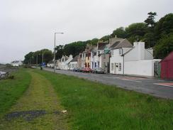
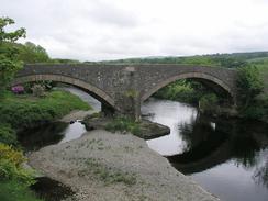
I walked down roads into Ballantrae, and met Sam by the main road in the village. On the way into the village I passed the lovely double-arch bridge, which was made from the stones of the ruined fifteenth-century Ardstrinchar castle. The bridge has now been bypassed by a new road and bridge, which gives some nice views of the old bridge, with the castle perched above it. As I approached the centre of the village I heard a big squeal of brakes as two skip lorries nearly collided; one had stopped to overtake a car and the one behind had to brake heavily to stop smashing into it, and left a thick black mark on the road. This little excitement being over, I entered Mervan and ate my sandwiches as I chatted to Sam.
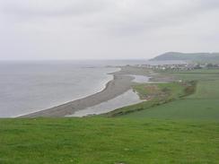
The last six miles of the day were along the A77(T), and was going to be quite boring. There was a little diversion, however; at Bennane Lea a road leads off to the left. This used to be the old main road, and was closed when the diversion, which takes a more inland route, diverts off. The old road is quite eerie, as the white lines along the road were still visible but grass was starting to encroach from the verges. I soon had to clamber over a gate covered in barbed wire, but after this the walk was quite enjoyable and it was nice to be on a quiet road after the bustling A77(T). After a mile I had to clamber over another gate, which had so much barbed wire I felt like the gate was protecting an army camp rather than a disused stretch of road!
When I got back to Mervan I read my copy of the 'AA Book of the seaside', which has acted as a sort of bible on my walk. The book stated that there is a path that runs along the cliff top between Finnarts Bay and Ballantrae. This is annoying, as the path is not marked on my OS map and so I have no idea if the path really exists. It would have been nice to walk along this path if it exists, but I as not wanting to risk there not being a path.
I started reading Winston Churchill's 'The Second World War, part I' tonight, and it is quite fascinating stuff. It is quite important to realise that it is written from Churchill's perspective and is therefore understandably biased, but it is full of little details that I did not know before. It is very interesting to read about the way he saw things developing during the twenties. I had heard a quote of his after the war saying that in all history the Second World War was the easiest to avoid, and this book is giving me details of why he thought this was the case.
Directions
This walk starts off at a caravan park at the southern edge of the little village of Cairnryan. Leave the caravan site and turn right to head north along the A77(T) past the container port and through the village itself. After about three and three quarter miles a road leads off to the left at the southern edge of Finnarts Bay. Follow this road as it passes a little factory building and then continue on along a rough track. Continue along this for about a mile and a half northeastwards past Finnarts Farm and towards Craiganlea House. Just before this house a track leads off to the left and climbs uphill to the north through a wooded area.
This track curves up and leaves the wooded area to head northwards past Sandloch Hill. After a couple of kilometres it then curves to a more northeasterly heading, and shortly after it crosses Shallochwreck Burn another track leads off to the left. Follow this track northwestwards for a little under a kilometre and when this ends at a T-junction turn right along another track that continues for a mile before ending at a T-junction with a road at Low Ballochdowan. Turn left along this road and follow it as it heads in a roughly northerly direction past Craigalbert and Meadow Park. Shortly after Meadow Park a track leads off to the left to head northwestwards before ending at a farm near Downan Hill. Turn right along another track that soon reaches another farm at Downan, where the track becomes a public road and heads northeastwards for a little over a mile before ending at a T-junction at Galeffin. Turn left at this junction and follow another road northward for a few hundred yards before it ends at a T-junction with the A77(T) road. Turn left and follow the A77(T) northwards across the bridge over the river and into Ballantrae.
The rest of this walk as far as Lendalfoot follows the A77(T) as it heads northwards and then northeastwards with one exception. A little over two miles north of Ballantrae at Bennane Lea an old road leads off and climbs uphill for a mile before rejoining the A77(T). This section of road is fenced off with two gates that had barbed wire over them, but they were relatively easy to climb over. Once back on the A77(T) continue on northeastwards along the road to Ladenfoot, and this walk ends at a lay-by just past the outdoor centre in the village.
Distances
| From | To | Distance (m) | Ascent (ft) | Descent (ft) |
|---|---|---|---|---|
| Cairnryan | Ballantrae | 13.8 | 1572 | 1529 |
| Ballantrae | Lendalfoot | 6.5 | 407 | 505 |
This makes a total distance of 20.3 miles, with 1979 feet of ascent and 2034 feet of descent.
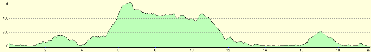
For more information on profiles, ascents and descents, see this page
Accommodation
There was nowhere to park in Lendalfoot, so we drove the six miles north to Girvan and parked in a lay-by to the south of the town, which had toilets next to it.
Disclaimer
Please note that I take no responsibility for anything that may happen when following these directions. If you intend to follow this route, then please use the relevant maps and check the route out before you go out. As always when walking, use common sense and you should be fine.
If you find any information on any of these routes that is inaccurate, or you wish to add anything, then please email me.
All images on this site are © of the author. Any reproduction, retransmissions, or republication of all or part of any document found on this site is expressly prohibited, unless the author has explicitly granted its prior written consent to so reproduce, retransmit, or republish the material. All other rights reserved.
Although this site includes links providing convenient direct access to other Internet sites, I do not endorse, approve, certify or make warranties or representations as to the accuracy of the information on these sites.
And finally, enjoy your walking!
This walk was mentioned in the following routes:
| My walk around the coastline of Britain |
Nearby walks
| # | Title | Walk length (miles) |
|---|---|---|
| 454 | Portslogan to Cairnryan | 24.1 |
|
|

|