Walk #662: A circular walk to Bardon Hill
 |
 |
|
General Data
| Date Walked | 16/04/2005 |
| County | Leicestershire |
| Start Location | Beacon Hill car park |
| End Location | Beacon Hill car park |
| Start time | 08.45 |
| End time | 15.47 |
| Distance | 19.8 miles |
| Description | This was a mixture of path and road walking, taking in Bardon Hill, the highest point in Leicestershire. |
| Pack | Today I carried my 70-litre Craghoppers rucksack, which contained Westwind tent, sleeping bag, inflatable roll mat and various electrical items. All of this weighed 13.7 kg (30.2lb). |
| Condition | I had some fairly significant problems with my feet today, which overheated and caused me a fair amount of inconvenience after the six mile mark. I had expected this as I was breaking in a new pair of boots, but it was annoying nonetheless. Aside from this I had no trouble, which was a relief considering the weight that I was carrying. |
| Weather | The day was a mixture of sunshine and cloud, and although a few of the early clouds were quite dark it never rained. It was a reasonably warm day, but it was just about comfortable for walking. |
| OS map | Landranger number 129 (Nottingham & Loughborough, Melton Mowbray) |
 |
 |
|
 |
 |
|
Map of the walk
Maps courtesy of Google Maps. Route for indicative purposes only, and may have been plotted after the walk. Please let me have comments on what you think of this new format. For a detailed table of timings for this walk, please see the table file.
 |
Notes
It had been a couple of weeks since I last did any walks, a time which I had used in updating many pages of my website. With the TGO Challenge less than three weeks away, I felt that I had to get out this weekend to start breaking in my new boots and to ensure that my shoulders were still used to the weight. It had been my intention earlier in the week to go away for the weekend and spend a couple of days walking along the North Downs Way. This turned out not to be possible, however; Sam is back from Australia for a couple of weeks and she wanted to visit me on Sunday, so I had to replan for a one-day walk today. I eventually settled on a circular walk in Leicestershire to take in Bardon Hill, the highest point in the county, which would also prove to be the first county top that I have done this year.
The drive to Leicester was long and fairly uneventful, the only problem being the closure of the B591 road heading north from the M1. I eventually made a long detour around via Coalville (missing all the diversion signs for the far shorter diversion route), but despite this I arrived at the Beacon Hill upper car park before nine, which was my target time. In Cambridge there had been fog, and much of the drive westwards along the A14 had been in sunshine, so I was naturally disappointed when I found that the clouds above were overcast, with only occasional glimpses of the sun visible.
I spent some time getting my boots on, as I wanted to ensure that the seams of my socks were in the correct place and not rubbing against my small toes - something that often causes trouble when I am breaking in new boots. I had weighed my rucksack this morning at around 30 pounds; heavy enough to give me a good workout, but as I hoisted it onto my shoulders I realised that it did not feel too bad. I locked the car and headed up to the top of the Beacon, where I paused to take some photographs of the trig pillar and the nearby topograph, the latter of which I had not had a chance to photograph on my last trip as it had been surrounded by people. At this time in the morning it was a very different story, as the top was deserted.
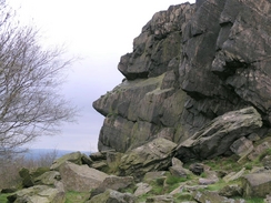
Unfortunately the overcast weather meant that the views were nowhere as good as they had been a few weeks before, and so I did not hang around and followed the path around past the Old Man of the Beacon (a rock outcrop in the outline of a face) before heading off down another path. This led across some rough and rocky ground before I joined a wide, surfaced path that led down to a road. A shot stretch of road walking led me to another footpath, which took me past a farm before ending at another road. I stayed on this road for much longer as it headed northwestwards, crossing the B591 by Bawdon Lodge and heading under the M1. About a mile later I passed Ives Head on the right; the gorse and rocky slopes looked very tempting for a climb as there is a trig pillar at the top, but there was no right of way and farmers were in a nearby field, so I decided against visiting the pillar and plodded along the road.
I finally left the road and followed a nice track that led down to Blackbrook reservoir. This reservoir was constructed in 1797 to provide water for the Charnwood Forest Branch canal. The original dam collapsed two years alter in 1799, closing the canal for several years. I had been hoping to take some nice photographs of the reservoir, but the lighting conditions were all wrong and so, after taking a few desultory shots, I followed the path as it headed uphill, eventually reaching a road by the unexpected Mount St Bernard Abbey, actually a Monastery. This monastery is quite historic; construction started in 1835, making it the first monastery to be constructed in Britain since the Reformation. It was replaced by the present building, designed by Augustus Pugin, in 1844. Even though I have passed many monasteries on previous walks I am always surprised that people would want to live that lifestyle in the modern age. The abbey church looked interesting from a distance with a tall stone tower, but I did not know if I could have a look around and so I continued plodding on along the road. Immediately to the north of the road there were many rocky outcrops and I took photographs of many of these as I walked.
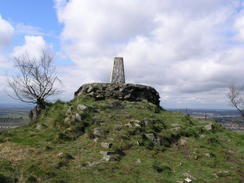
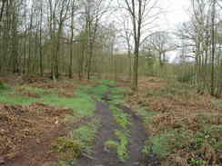
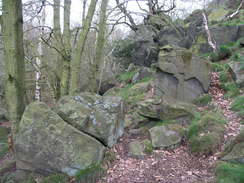
As I walked I noticed that there was a trig pillar in an area of woodland just off my route. I had not noticed this when I was planning the walk, and as there was a footpath running close by I decided to make a little diversion. I entered Cademan Wood via a little car park, and was soon following a wonderful path through the trees, with rocky outcrops springing out of the ground all around. When I was faced by a large and imposing rock outcrop rising about thirty feet above the path I realised that the pillar would be on top, and so I followed a rough path that led to the top. Once I finally managed to reach the pillar I was greeted with some fantastic views that really made the diversion and climb worth the effort. I stopped for a few minutes letting the views sink in, before recording the pillar details, taking some photographs and heading of.
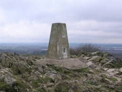
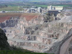
Another stretch of woodland path winding between rocky outcrops took me to a road beside a pub in the village of Whitwick, and I was faced with a road slog through the centre of the place. Annoyingly I passed no shops, and I soon found myself on a track that headed southeastwards past an imposing quarry fence towards Agar Nook. A good path kept me off the road for most of the time, before dumping me unceremoniously onto the road for the last few hundred yards. After this, however, footpath took over, as I started the climb up towards the top of Bardon Hill, the highest point in Leicestershire and my main target for the day. On the climb I could look down into the massive Bardon Hill Quarry, which is still in use and a gigantic scar that has taken away the entire northern side of the hill. I could see the trig pillar in the distance, seemingly standing right on the edge of the sheer cliff down to the quarry floor hundreds of feet below.
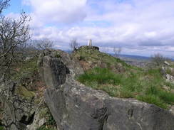
I soon reached the pillar, having to pass a large communications mast on the way, and sat down on the raised plinth that the pillar stands on. I was instantly drawn to the views, which were routinely expansive; even the presence of the quarry added to the views rather than distracted from them. I could make out several Trent Valley power stations (including the massive Ratcliffe-on-Soar), and tower blocks on the outskirts of Nottingham were also clearly visible. I sat down for ten minutes, studying the views all around. I was on a metaphorical high, and even my aching feet could not distract me as I stared. Eventually I got up and took a panoramic photo with my camera - hopefully it will have turned out okay. After this with regret I walked away, passing the communications mast before taking a track that led down the southern side of the hill, crossing an unexpected quarry haul road forming an ugly scar across the hill, before taking a footpath southeastwards towards the A511.
At the A511 / B591 roundabout, which was under reconstruction and caused my diversion earlier in the day, I nipped into a petrol station to buy a couple of chocolate bars, which I proceeded to munch on as I walked southwards along the road that skirted Cliffe Hill. This hill is another quarry, and apparently there is even a tunnel connecting it with another nearby quarry face! On the road near Horsepool Grange there was a horse, tethered to the fence and with a neat semicircle of trampled and munched grass surrounding it. I patted it and took a couple of photos, and could not help but feel sorry that it did not have more room to walk around in. Horses are majestic beasts, and tethering it in such a way seems strangely wrong to me.
I followed another road as it crossed the M1, and then took a footpath that led towards the village of Markfield. Near the church I diverted off to climb up towards a trig pillar marked on the map and, yes, it was situated at the top of another quarry. This one had recently been converted into a nature reserve, and the blue water of a little pond at the bottom was somewhat offset by the ugly blue railings guarding it. The pillar itself was in a superb position, standing right at the edge of the quarry face, and with a disconnected ridge of walk a few yards away. This ridge was fascinating, and I found myself thankful that the pillar had not been on that instead of the less precipitous ground on which it strands. After taking some photographs I headed off and walked through Markfield, eventually crossing the A50 via an underpass before following the Leicestershire Round path eastwards.
By this time my feet were really aching and were starting to hamper my progress. I could see that I had plenty of time left for the rest of the walk, and so I slowed down slightly, trying to enjoy the view despite the pain. In the distance I could see the war memorial in Bradgate Park (which I had visited a few weeks earlier), and the path slowly took me on towards this. By now the sun was out and I was very tempted to continue along the Leicestershire Round into Bradgate Park, and then follow the route that I had taken earlier, but my aching feet precluded this. Inst3ead I took another footpath that headed northeastwards before ending at a road near Blakehay Wood. After a short distance this led to another road, which I in turn followed towards the car park near Old John Tower.
The rest of the walk was to be along roads, and I found that although the surface was hard on my feet it allowed me to keep a good speed up. There was not much to see and the road was fairly busy, so I ambled along thinking and watching out for oncoming cars. Eventually I reached Beacon Hill crossroads, where I turned for the short distance towards the car park and my car. When I arrived at my car I could see that Beacon Hill was very busy, especially when compared to this morning when it had seemed deserted I really wanted to go up and take some photographs of the views in the sunnier weather, but my feet were complaining and I decided that it would be best to hit the road. This was a mixed walk; too much road walking, but it served it purpose in acting as an intense way of breaking in my boots.
Directions
This walk starts off at the upper car park in the Beacon Hill country park. Leave the car park and walk up the short distance towards the top of the hill. Just before the trig pillar is reached there is a wide gravel footpath; turn left and start following it as it heads around the western side of the hill. After about a hundred yards the Old Man of the Beacon is reached on the right beside an information board; here leave the gravel path by turning left along an indistinct path that heads downhill across some craggy ground. When this path meets a track turn right and follow it northwestwards past a curious turf-roofed shelter, before the track shortly ends at another gravel path. Turn left along this path and follow it as it heads southwestwards, before ending at a road.
Turn right and follow the road downhill northwestwards for a couple of hundred yards. At a road junction on the right turn left along a footpath that initially skirts a farm before heading through a field. The path turns to the right for a few yards before turning left, to regain a south-westerly course and ending at a road. At the road turn left and start following as it heads northwestwards; after a few hundred yards it crosses the B591 road by Bawdon Lodge before continuing on to pass under the M1 by a bridge. Continue along the road as it skirts under Ives Head and reaches a crossroads; head straight on for another couple of hundred yards until a track and byway lead off to the left.
Follow this byway as it heads downhill along the track, reaching a causeway across Blackbrook Reservoir. Cross the causeway and once on the other side turn right along a footpath. This cross a field parallel to the reservoir before crossing a hedge and turning left to head uphill with the hedge on the left. The path enters the woodland and is easy to follow as it heads uphill. It crosses a rough track and heads on, before eventually ending at a road; turn right and start following the road as it heads westwards, immediately passing Mount St Bernard Abbey. After about a mile a road junction is reached on the right; turn right along this road for a hundred yards until a small car park is reached in the woods to the left. Enter the woodland here, and start following a path that heads westwards through the trees; when a large rock outcrop is reached on the left climb up it if you wish to visit a trig pillar. If not, continue on along the footpath as it heads through the rocky terrain of Cademan Wood before ending at a road near a pub in Whitwick.
Turn right along the road for a few yards before turning left, to follow Cademan Street, which heads slightly west of south towards the centre of the village. Shortly after it passes near a church the road curves to the left to take a more easterly course. Once the road starts heading up a slight hill turn right along St Bernard's Road and then take the first road off to the left, Beaumont Road. This heads south-eastwards for a couple of hundred yards; when it ends turn left up St Bernard's Road again for a few yards until a footpath leads off to the right. Join this footpath and follow it as it heads southeastwards through some woodland, before joining a track that runs alongside a large and imposing fence to the left. The fence is soon left behind, but the path continues on dead-straight; it crosses a road before entering Agar Nook, where it runs behind some houses. Eventually the path is forced to join the residential roads; follow them to a larger road, and cross this to start walking up a little cul-de-sac.
A footpath leads off straight ahead, crossing a field in a southerly direction and slowly climbing up towards some woodland. When the woodland is reached turn left along a track for a hundred yards before following the footpath as it heads off to the right, climbing uphill through the trees along an obvious track. It soon emerges from the trees, and the path is easy to follow as it heads uphill near to the edge of Bardon Hill quarry. Once the path ends at a track near a large transmission mast turn right and walk past the transmission mast to a trig pillar, which marks the highest point on the hill and also the entire county of Leicestershire.
Head back towards the mast and join the track that heads downhill to the east. Once this joins a wide, rough quarry haul track continue straight ton for a few yards to gain access to a smoother track that parallels it. Turn right along this track for a hundred yards before turning left along a footpath. This footpath heads southeastwards passing under power lines before passing the farms at Old Rise Rocks and Rise Rocks Farm, where it joins a track down to the A511 road. Turn left and follow the pavement beside the A511 eastwards for a few yards until a roundabout is reached, and then turn right to follow another road. Initially this heads southwestwards before curving to head in a southerly direction past the western edge of the quarry on Cliffe Hill.
The road passes Horsepool Grange as it starts curving to the left to head in an easterly direction. When a roundabout is reached turn left and follow another road downhill to a bridge over the M1. Cross the M1 via the bridge and once on the other side turn left up another road. About a hundred yards up this road turn right along a footpath that heads eastwards uphill for a short distance into the village of Markfield. The path joins a track that soon becomes a road as it passes the church. When a T-junction is reached turn left and start following a track northwards; after a few yards a footpath leads off to the left into an area of parkland; at the top of this path a trig pillar can be found.
Once you have visited the pillar return to the track and follow it northwards, before it eventually heads off to the right to join a residential road in Markfield. Turn left and head north along this road until it ends at a T-junction with another road. Turn right along this road for a few yards until a footpath heads off to the left, carrying the Leicestershire Round long-distance path, which will be followed for the next few miles. Follow the path as it heads under the A511 via a pedestrian underpass, after which it turns to the right and skirts the northern side of the A511 south-eastwards for a few hundred yards. As the A511 approaches a roundabout the footpath diverges away from it, heading in a more easterly direction. The path skirts to the north of an area of woodland before crossing a field and reaching a track near a house. Continue on along the path as it skirts the southern edge of John Lee's Wood.
When the eastern edge of the woodland is reached turn left to follow another footpath northwards for a few yards, leaving the Leicestershire Round in the process. This new path soon turns to the right to leave the woodland and is easy to follow as it heads slightly north of east, entering an attractive area of woodland before ending at a road. Turn right along this road for a few yards until it ends at a T-junction, and then turn left to follow this road northwards, skirting the eastern edge of Blakeshay Wood. When a road junction is reached on the left after about a kilometre, with the entrance to a car park on the right, turn left and start following this road as it heads northwestwards. Follow it for a little under two miles as it passes to the east of Benscliffe Wood (*), crosses a crossroads and continues on until Beacon Hill Crossroads is reached. Here turn right, and follow another road uphill to the northeast for about a hundred yards until the entrance to Beacon Hill upper car park is reached on the left. Turn left and enter the car park, where this walk ends.
(*) Please note that Benscliffe Woods are private land, and on no account should be entered.
Distances
| From | To | Distance (m) | Ascent (ft) | Descent (ft) |
|---|---|---|---|---|
| Beacon Hill car park | Blackbrook Reservoir | 4.2 | 207 | 560 |
| Blackbrook Reservoir | Bardon Hill | 6.0 | 919 | 423 |
| Bardon Hill | Markfield | 4.5 | 420 | 681 |
| Markfield | Beacon Hill car park | 5.1 | 482 | 364 |
This makes a total distance of 19.8 miles, with 2028 feet of ascent and 2028 feet of descent.
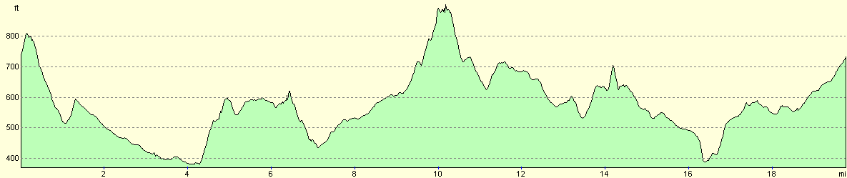
For more information on profiles, ascents and descents, see this page
Disclaimer
Please note that I take no responsibility for anything that may happen when following these directions. If you intend to follow this route, then please use the relevant maps and check the route out before you go out. As always when walking, use common sense and you should be fine.
If you find any information on any of these routes that is inaccurate, or you wish to add anything, then please email me.
All images on this site are © of the author. Any reproduction, retransmissions, or republication of all or part of any document found on this site is expressly prohibited, unless the author has explicitly granted its prior written consent to so reproduce, retransmit, or republish the material. All other rights reserved.
Although this site includes links providing convenient direct access to other Internet sites, I do not endorse, approve, certify or make warranties or representations as to the accuracy of the information on these sites.
And finally, enjoy your walking!
Nearby walks
| # | Title | Walk length (miles) |
|---|---|---|
| 138 | Market Harborough to Leicester | 17.7 |
| 654 | Leicester to Loughborough | 19.0 |
|
|

|