Walk #133: Hunstanton to Burnham Deepdale
 |
 |
|
General Data
| Date Walked | 20/01/2001 |
| County | Norfolk |
| Start Location | Hunstanton Cliff top car park |
| End Location | Burnham Deepdale |
| Start time | 09.19 |
| End time | 14.17 |
| Distance | 10.3 miles |
| Description | This was a very nice walk, following roads and sections of the North Norfolk Coast Path. The going was quite flat, although some of the beach sections could be quite hard going. |
| Pack | I did not carry a pack today. |
| Condition | I feel okay after today's walk, and I could have walked much further if I had needed to and had had more time. My feet have not suffered in the same way as they did in the last walk, which is a relied. I have nothing to complain about although Sam's feet have suffered today. We stopped early on and put some Compeed plasters on her heels and they appeared to have stopped the problems that she was having. |
| Weather | Today was quite cold, with patches of snow still lying on the ground from yesterday. On the drive up to Hunstanton from Waterbeach there was a great deal of fog about, but fortunately by the time the journey ended the vast majority had dissipated. At a few points the sun managed to peek through the clouds, but for most of the day the sun was obscured. After we finished the walk the mist came down and visibility reduced again. Fortunately whilst we were walking it remained dry. |
| OS map | Landranger number 132 (North West Norfolk, King's Lynn & Fakenham) |
 |
Map of the walk
Maps courtesy of Google Maps. Route for indicative purposes only, and may have been plotted after the walk. Please let me have comments on what you think of this new format. For a detailed table of timings for this walk, please see the table file.
Notes
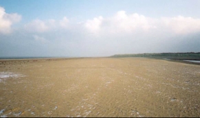
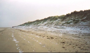
There is something about coastal walking that is most nice - whether it is the ever-changing dynamism of the sea / shore interface or the way it can excite four senses - the taste of salt in the air, the sound and smell of the sea and the feel of sand and shells. Today's walk was enlivened by a certain amount of beach and salt marsh walking that made the road walking sections worthwhile.
Between Hunstanton and Thornham we passed the beach at Holme, which became famous in 1999 following the discovery of 'Seahenge', a prehistoric timber circle discovered on the beach. I was lucky enough to see this in early 1999 when I was walking along the beach before it was removed for study. Just before this latest walk it was announced that another, smaller wooden circle had been found a hundred yards away from the original one, but this time I did not bother to try and find it.
On the way from the beach into Thornham we passed through the Norfolk Wildlife Trust's Holme Dunes Nature Reserve, which covers over 281 hectares between Lavender Marsh and Ragged Marsh (essentially taking in the seafront between Holme and Thornham).
We could not move today for birdwatchers as they were everywhere. At first when you approach them they seem like walkers, but as they get nearer you notice that they generally have smaller backpacks on than walkers (even ramblers), and carry the obligatory binoculars. They also tend to stop at very regular intervals right in front of you and look at an area of sand or sky that does not seem worthy of such attention. They seem to enjoy themselves, however, so who am I to complain.
Thornham Church seemed a strange church to me, as it appeared much taller than churches of an equivalent size, and had a 'tower' that was not much taller than the main body of the church. Apparently work on the tower was started but the Black Death intervened and work was not finished until the 1930's.
Thornham apparently used to be a busy little port, and a seat in the entrance to the gateway of the church commemorates the captain of the last commercial boat to use the port. Unfortunately I did not write down the details so I cannot tell you any more.
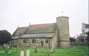
The walk finished at the little hamlet of Burnham Deepdale, which seemed to only contain a few houses, a petrol station and a church. We stopped at the petrol station to enquire about the correct location of the bus stop and I mentioned the attractive little church. The lady behind the counter gave me a key and told me to have a look around. Since we had thirty minutes to wait for the bus I did so and was very glad, for it was a beautiful church.
The church has three main features: A Saxon round tower, a Norman font and a collection of medieval glass. The tower in itself was quite spectacular and has been dated at being about 950 years old because it had a triangular headed doorway, it was constructed with some large puddingstone material near the base and the thickness of the walls was less than that of a Norman tower. On the wall on the entrance to the tower was a list of all the vicar's at the church since 1305, which was quite an amazing thought! The church has had major restorations three times, in 1797, 1855 and 1898. In the 1797 restoration the Norman font was broken and was taken to Fincham Rectory for repair, but stayed in a garden there for forty years before being returned!
Directions
This walk starts off at the cliff top car park in Hunstanton (which is actually an area of roadside parking), which is next to the ruins of an old church. Head towards the lighthouse at the top of the cliff from the car park and then take a sandy path that heads slowly down to the beach. Just before it reaches the beach the North Norfolk Coast Path heads off to the right; this can be followed but instead I chose to walk along the beach.
Join the beach and turn right to head north-eastwards along it. Soon you pass the RNLI lifeboat station at Old Hunstanton, after which the coast starts to run to a more easterly heading. After a few miles you pass Gore Point, and about a mile east of the Point at about 720 450 turn south and head inland along the raised flood bank to the east of Broad Water.
Head south along the flood bank to the gate at the entrance to the nature reserve. Turn left and follow another flood bank east to the river and then south to eventually meet a road just to the north of Thornham. Cross the road and take a footpath to the left that leads eastwards before descending into Thornham.
When the road is met take Green Lane south out of Thornham until the A149 is met. Turn left and follow the A149 for a couple of miles, passing through the hamlet of Titchwell until the church at Brancaster is reached, opposite the A149 / B1153 road junction.
Turn left down a road that leads to a car park at Brancaster beach, and then turn right down a footpath that leads behind houses and immediately to the north of the Brandovnum roman fort. This path is part of the North Norfolk Coast Path, and is very boggy as it is on the fringe of the tidal area of Brancaster Mow Creek, and it is therefore handily raised up on a wooden causey. Continue along this path eastwards as it parallels the A149 through Brancaster Staithe. When another section of flood bank is reached leading off to the left turn right and walk a short distance to the A149 at Burnham Deepdale church.
Distances
| From | To | Distance (m) | Ascent (ft) | Descent (ft) |
|---|---|---|---|---|
| Hunstanton car park | Gore Point | 2.8 | 10 | 85 |
| Gore Point | Thornham | 3.1 | 43 | 16 |
| Thornham | Burnham Deepdale | 4.4 | 112 | 121 |
This makes a total distance of 10.3 miles, with 165 feet of ascent and 222 feet of descent.
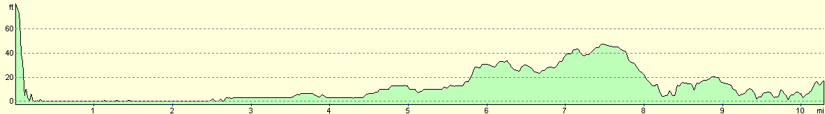
For more information on profiles, ascents and descents, see this page
Transport
There are some bus services running between Wells-Next-The-Sea and Hunstanton, calling at most of the villages on the route of the A149. These bus services are called the 'Coastliner' and are very infrequent in the winter timetable, but they are available nonetheless.
Accommodation
We stayed in the Globe Inn in Wells-Next-The-Sea. This is beyond the end of the walk, and we drove to it from Hunstanton ready for the next section of the walk. The B&B accommodation cost us 40 pounds for the night for the two of us, and the accommodation was reasonable, but not as clean as I normally like (the bath was old and stained), and there was loud music from the pub below until late in the night. It was better than camping out or driving back to Cambridge, however, and the cooked breakfast in the morning was very nice.
Disclaimer
Please note that I take no responsibility for anything that may happen when following these directions. If you intend to follow this route, then please use the relevant maps and check the route out before you go out. As always when walking, use common sense and you should be fine.
If you find any information on any of these routes that is inaccurate, or you wish to add anything, then please email me.
All images on this site are © of the author. Any reproduction, retransmissions, or republication of all or part of any document found on this site is expressly prohibited, unless the author has explicitly granted its prior written consent to so reproduce, retransmit, or republish the material. All other rights reserved.
Although this site includes links providing convenient direct access to other Internet sites, I do not endorse, approve, certify or make warranties or representations as to the accuracy of the information on these sites.
And finally, enjoy your walking!
This walk was mentioned in the following routes:
| A walk around East Anglia |
Nearby walks
| # | Title | Walk length (miles) |
|---|---|---|
| 9 | Old Hunstanton and Holme | 4.0 |
| 134 | Burnham Deepdale to Wells-Next-The-Sea | 9.5 |
| 156 | Kings Lynn to Snettisham | 14.6 |
|
|

|