Walk #489: A walk up Ben Nevis
 |
 |
|
General Data
| Date Walked | 03/07/2003 |
| County | Highlands |
| Start Location | Glen Nevis Visitor Center |
| End Location | Fort William Railway Station |
| Start time | 07.29 |
| End time | 15.58 |
| Distance | 11.7 miles |
| Description | This was a short but very dramatic walk, which could hardly be more different to yesterday's, and took in the top of Ben Nevis. |
| Pack | Today I carried my 30-litre Karrimor HotRock rucksack, which was filled with my packed lunch, waterproof leggings, water bottle and a couple of spare shirts, together with the usual assortment of odds and ends. |
| Condition | I have had some fairly significant problem with my right shoulder today, which was aching a lot at times on the descent. Aside from this I was absolutely fine, and could easily have walked on further. |
| Weather | The day started of with a thin and low cloud layer, but in the afternoon this burnt off leaving a mainly blue sky. The afternoon got quite warm, but by that time I was on the descent. This made it an absolutely superb day for a mountain walk. |
| OS map | Landranger number 41 (Ben Nevis, Fort William & Glen Coe) |
 |
 |
|
 |
 |
|
Map of the walk
Maps courtesy of Google Maps. Route for indicative purposes only, and may have been plotted after the walk. Please let me have comments on what you think of this new format. For a detailed table of timings for this walk, please see the table file.
 |
 |
|
 |
Notes
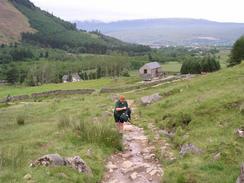
I set off early this morning, as I was keen to get up to the top of Ben Nevis before I got too hot. Last night before we had gone to bed he skies were blue, but this morning when I lifted the blinds there were clouds everywhere. This did not dishearten me too much, as I was quite looking forward to the walk anyway. Sam joined me for the initial stretch from the car park at the Ben Nevis Visitor's Centre, and we chatted as we walked. At the junction with the path that leads up from the youth hostel we met a lady from New Zealand, and we walked and talked until we nearly reached the lochan, where the two ladies turned back and I continued on.
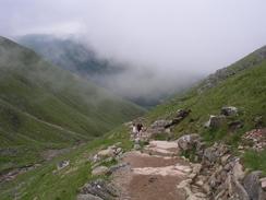
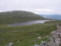
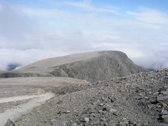
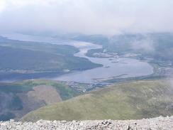
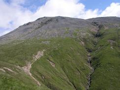
I love the little lochan that lies between Ben Nevis and the adjacent mountain, and it looks superb from above when the sunlight shines on it. I was too busy trying to reach the top of the mountain to sped any time there on the way up, and I found that once Sam had left me I could pretty much power up the mountain. Near the waterfall I passed through a thin cloud layer, and a couple of hundred feet further up the mountain this ended and I was above it. This led to the lovely sight that you often get on mountains, of seeing a loud layer below you laid out like a silky sheet, with the tops of the surrounding mountains sticking up out of the cloud. It was a truly magical sight, and one that I never tire of seeing.
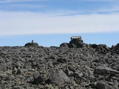
Near the top of the mountain there was a small patch of snow residing in a sheltered area, and I was amazed that there should be such obvious snow on the mountain in July. When I reached the summit there was a family of three Australians at the top, and we did the usual act of swapping cameras so that photos could be taken. They started their descent, and I stayed at the top looking around the plateau. After a while an elderly gentleman joined me, and as we chatted it turns out that he is sixty-nine years old, and had just made his first ascent of the mountain. He was a fascinating fellow, and we started the descent down the mountain together.
I took the descent down the mountain quite slowly as we chatted, He found the descent quite hard (as did I - the descents are always harder than the ascents), and at one stage his leg buckled twice. Eventually he sat down on a rock for a rest, and bade me to continue on. As the mountain was now resembling the M1 I felt okay leaving him, and I strode on alone. It gives me an immense and somewhat sadistic feeling of satisfaction to be going down a mountain whilst others are going up, and take pride in my early start. Some of the people going up were impressively ill dressed for a day on the mountain, and if the weather were to change suddenly they could be in trouble - many had no packs and were wearing summer clothing. At the best of times the temperature at the summit is niene degrees lower than at the base, and if the wind is blowing the wind chill can make this much more. Many people die on the Ben every year, and it is no surprise when you see the disdain with which people treat the mountain. In my pack I had two litres of water, a water filter, waterproof coat and trousers, some food and, most importantly, a survival bag. This load was not very heavy and is the bare minimum that people should take with them up such a mountain.
As I was nearing the bottom of the mountain I passed a couple of men climbing up. I had a quick chat with them, and it turns out that they were stewards for a four peaks challenge that was starting at four this afternoon. They asked me what time I had set off, and when I said seven thirty they asked if I had been up and down twice! This was ever so slightly deflating, and when I got down to the bottom the competitors' cars were just arriving. There was time for a quick rest, but their cars were starting to block us in and we decided to leave before it got worse, and after some manoeuvring we managed to get Mervan out. The competition was the Vauxhall four peaks challenge, and they have to do Ben Nevis, Scafell Pike, Snowdon and Northern Ireland's highest mountain in forty-eight hours - quite a challenge!
The last bit of the walk was a nice little stroll down the road from the Ben Nevis Visitor's Centre to Fort William Station. On the way I met a gent with rucksack on, and as we chatted it turns out that he had just completed the West Highland Way as part of a Land's End to John O'Groats walk. When Sam met us at Nevis Bridge we continued walking together, and we ended up inviting him into Mervan for dinner once we had had a couple of pints. He is a truly lovely gent, and it was great chatting to another long distance walker for a few hours. Sam and I had intended to go out again for a couple more drinks, but I was too knackered and once the gent left I just collapsed onto the bed. All in all it has been a strange day - I feel strangely dissatisfied with having climbed the Ben, but I met some very nice people on the way, which counts for a lot.
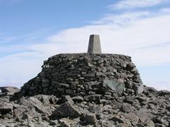
On the summit is the remains of the old meteorological station, built by Public subscription and opened on the 17th of October 1883. It was manned throughout the year by a superintendent and two assistants and provided meteorological observations every hour for 20 years. It is now ruined, but enough remains to make you admire the hardy people for whom this was home. It finally closed on October 1st 1904 after the funds to run it ran out, and over the years it slowly fell into disrepair.
The record for running up and down the mountain is held by Mr. Kenneth Stuart, who made it to the top and back down again in a remarkable 1 hour, 25 minutes and 34 seconds during a Ben Nevis race. The ladies time is an equally impressive 1 hour, 43 minutes and 25 seconds, by Pauline Haworth. Considering that this is a quarter of my time I think that I can honestly say that there is no hope of me beating it - but who would want to? Surely racing up and down hills like this stops you from being able to view the glorious scenery?
Directions
This walk starts in the car park of the Ben Nevis Visitors Centre, Situated in Glen Nevis at NN 1220 7295. Go through the car park until you meet the River Nevis, and then turn left to follow the western bank of the river northwards to the end of the car park. Here a footbridge carries you over to the eastern bank of the river.
On the eastern bank of the river a footpath leads southwards for a short distance, before it turns to the left and heads eastwards for a short distance through the grounds of Achintree House. A stile leads across from the path to meet the end of a road. Turn right at the road and join the Ben Nevis Mountain Track (which was previously called the Ben Nevis Tourist Route) as it heads southwards. As it does so it starts to rise from 30 metres above sea level at the road to 150 metres at NN 1320 7215, where the path leading up from the Youth Hostel in Glen Nevis meets the Mountain Track.
The track continues to rise as it skirts the western side of Meall an t-Suidhe, zigzagging twice and crossing a couple of streams by means of a couple of funky small metal bridges to reach 350 metres above sea level. The track then starts to veer northwards, following the western bank of the Red Burn Gully. Another, larger zigzag takes you up to the saddle between Ben Nevis to the east and Meall ant-Suidhe to the west at 570 metres above sea level.
The track passes to the east of Lochan Meall an t-Suidhe that lies in the saddle. It then turns to the right to start the ascent up the western side of Ben Nevis. At NN 1473 7186 the track crosses the Red Burn under a waterfall, and this marks the halfway point of the ascent, at 600 metres above sea level.
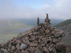
From the Red Burn the track continues up the northwestern shoulder of Ben Nevis in a series of four giant zigzags. These bring you out at the 1,200-metre level, and the gradient of the track starts to flatten out as it heads in a westwards direction. One last, but thankfully short, ascent of McLean's Steep leads to the summit plateau. Across here careful navigation is needed to reach the summit cairn at 1,344 metres above sea level. The summit plateau is bounded on the northeastern side by some very steep drops, including Tower Gully and Gardyloo Gully, which the path runs adjacent to. Be careful to avoid these gullies, particularly in winter when cornices may have formed over the edge.
To return from the top, continue down on the same route that you came up. There are other routes down the Ben which can be used if you are an experienced climber in good weather, including one along the Carn Mor Dearg Arete to Carn Mor Dearg and Carn Beag Dearg.
When you reach the visitor centre in Ben Nevis once more leave the car park and join the road. This leads northwards along Glen Nevis for about a mile and a half to the roundabout at Nevis Bridge. Go straight on at the roundabout and follow the road for half a mile into the town centre. The railway station is immediately to the right at the roundabout.
Distances
| From | To | Distance (m) | Ascent (ft) | Descent (ft) |
|---|---|---|---|---|
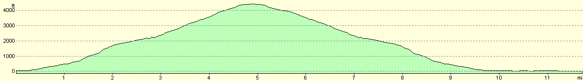
| Ben Nevis Visitor's Center | Ben Nevis summit | 5.0 | 4478 | 118 |
| Ben Nevis summit | Ben Nevis Visitor's Center | 5.0 | 118 | 4478 |
| Ben Nevis Visitor's Centre | Fort William Railway Station | 1.8 | 131 | 167 |
This makes a total distance of 11.7 miles, with 4727 feet of ascent and 4763 feet of descent.
For more information on profiles, ascents and descents, see this page
Accommodation
We parked Mervan in a car park by the station in Fort William, which was the only place that we could find in the town that did not seem to have any parking restrictions. It was quite handy for the town, although we did not need to go in tonight.
Disclaimer
Please note that I take no responsibility for anything that may happen when following these directions. If you intend to follow this route, then please use the relevant maps and check the route out before you go out. As always when walking, use common sense and you should be fine.
If you find any information on any of these routes that is inaccurate, or you wish to add anything, then please email me.
All images on this site are © of the author. Any reproduction, retransmissions, or republication of all or part of any document found on this site is expressly prohibited, unless the author has explicitly granted its prior written consent to so reproduce, retransmit, or republish the material. All other rights reserved.
Although this site includes links providing convenient direct access to other Internet sites, I do not endorse, approve, certify or make warranties or representations as to the accuracy of the information on these sites.
And finally, enjoy your walking!
This walk was mentioned in the following routes:
| My walk around the coastline of Britain |
Nearby walks
| # | Title | Walk length (miles) |
|---|---|---|
| 152 | Kings House Hotel to Kinlochleven | 8.7 |
| 153 | Kinlochleven to Fort William | 14.1 |
| 154 | Ben Nevis from Fort William | 11.8 |
|
|

|