Walk #755: A circular walk from Cold Ashby to Long Buckby
 |
 |
|
General Data
| Date Walked | 13/01/2007 |
| County | Northamptonshire |
| Start Location | Cold Ashby |
| End Location | Cold Ashby |
| Start time | 08.37 |
| End time | 15.26 |
| Distance | 19.9 miles |
| Description | This was a combination of footpath, bridleway, canal towpath and road walking to make a circular walk around the Northamptonshire and Leicestershire border. |
| Pack | Today I carried my 30-litre Karrimor rucksack filled with my waterproofs, two litres of water, and various other odds and ends. |
| Condition | I feel relatively okay after this walk; the inside of my left ankle hurt for the last mile or so, but I had very little trouble with my knees. |
| Weather | The day started off cloudy with some fairly heavy drizzle showers in the air; as the day went on the length and severity of these lessened, and at one stage there was even some sun. It was a very warm day for the time of year (in double figures), but there was a fierce wind that was chilly at times. |
| OS map | Landranger number 141 (Kettering, Corby & surrounding area), Landranger number 140 (Leicester, Coventry & Rugby) and Landranger number 152 (Northampton & Milton Keynes) |
 |
 |
|
 |
 |
|
Map of the walk
Maps courtesy of Google Maps. Route for indicative purposes only, and may have been plotted after the walk. Please let me have comments on what you think of this new format. For a detailed table of timings for this walk, please see the table file.
 |
 |
|
 |
 |
|
Notes
I had been planning this walk since last July, when I had done a circular walk down from Welford to Crick, partly along the Leicester branch of the Grand Union Canal. Previously I had walked along the main line of the Grand Union, and I had planned this walk to complete the walk down from Crick to the main line at Norton Junction. The weather forecast for today was not too good, but I decided that this would be a pleasant walk to do; it is not too far away from my home, and would allow me to make many short cuts if my knees started playing up.
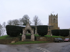
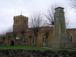
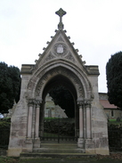
It took me a little under and hour to drive westwards along the A14, and I parked up by the church in Cold Ashby in a light drizzle, with grey clouds overhead not boding well for the rest of the day. As usual I took my time putting my boots on and getting my kit together, and whilst my GPS acquired the satellites circling high overhead I took some photographs of the lovely war memorial outside the church, which is a stone archway that is set off well against the church itself.
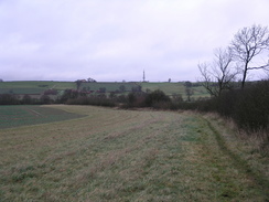
Due to the drizzle and clouds I decided to take my fleece off and put my coat on instead; it was surprisingly mild for the time of year, and I was afraid that if I had both layers on I would overheat. Once this was done I set off, and plodded along the road through the village before taking a long road that headed westwards towards Honey Hill. There was a trig pillar marked on the map, and as I passed I could see it sitting proudly in the field to my left. I could not be bothered to go and visit it, and instead took a couple of snaps of it from the road before continuing on a short distance to a large and very prominent communications mast on the left,
It was easy to see why the mast was situated here, as there were some very expansive views southwards from the ridge, and I enjoyed these as I left the road and started to follow the Jurassic Way as it headed southwards down a firm track, passing a house on the left before it eventually ended by Honey Hill Farm. After passing through a small patch of woodland populated with small trees the path crossed a golf course, before descending down to meet a stream that was running fast after the heavy rain of the last few days,
The path climbed up the other side and started heading across some muddy fields; the waymarking was not that good, and it was with some difficulty that I managed to fund my way across the fields and down the track to Winwick. The first sight I got of the hall was through the ornate gates on the northern side of the wall guarding the hall; by the gates there were some circular pillars with steps leading up to the top of the pillars - quite what the steps are for I do not know. A quick walk took me around to the main entrance to the hall, and inside the grounds there were several workmen working hard on the rebuilding of the hall.
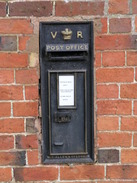
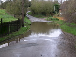
On the wall by the gate there was an unusual private pillar box, painted black, and on the other side of the gate there was a standard red pillar box. This left me wondering why the hall required a private pillar box, and a few yards further on I came across Winwick war memorial; a bus shelter with a water faucet in it. A few yards further on there was a stretch of road that had been flooded by the recent heavy rain, and I carefully made my way across this before starting on a long stretch of road.
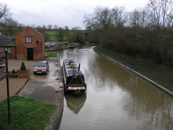
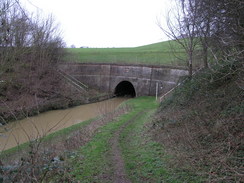
There was not much to see on this stretch, and it was a relied when a footpath took me on westwards towards Crick. On the way the footpath passed between a cottage on the right and a series of lakes descending down the hillside to the left; I assume that these were small fishing lakes, but they did seem rather small. The footpath ended by the A428 road in Crick, and this marked the point that I had reached on my previous walk. I followed this to the bridge over the canal, but there was little point in descending down to the canal; Crick tunnel is a short distance to the south of Crick Wharf, and I had to bypass this.
I walked on towards Crick, stopping at a shop to buy some chocolate and a packet of crisps as I had forgotten to take my usual packets of nuts and raisins with me. I had a quick chat to the lady behind the counter and started my walk through the village, which was fairly pleasant. A long road walk took me out of the village and back towards the canal; as I walked along one road towards the southern portal a line of mounds became visible in the fields to my left, obvious signs of the tunnel that lay underneath.
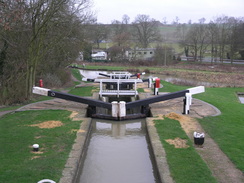
A short track took me down to the southern portal of the tunnel, and once I reached this I started walking along the canal. The area was fairly noisy, with noise from a railway line and then the M1, which the canal passed under to reach the first of the Watford flight of locks. There were some pleasant views to be had down the flight, and I spent some time taking some photographs before heading on.
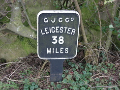
This stretch of the canal skirted around the M1, the noise of which was always with me, and passed right behind the Watford Gap services, passing a fairly dinghy area near the petrol station. It was hardly the most salubrious section of canal towpath that I have ever walked, but as the canal continued southwards it headed slightly away from the motorway and the noise abated slightly. Before I knew it I passed the Welton Hythe Marina, and soon reached Norton Junction with the main line of the Grand Union Canal.
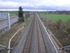
I had walked the Grand Union Canal on a couple of different occasions, but this time I only stayed on it for a quarter of a mile to the Buckby top lock, after which I joined the A5 for a few yards before taking a footpath that headed easily across fields. As I walked the noise from the motorway increased, and the path crossed the railway line, and then immediately afterwards the motorway, the last time that I would cross it today. The path descended to cross a stream, immediately after which is ascended up a slight slope to cross a track before descending once again to head towards another railway line.
There was a large barn on the left just before the bridge under the railway line, and as I approached about ten cows looked out towards me, seemingly giving me curious looks until I disappeared out of view under the bridge. A little climb took me up towards the outskirts of Long Buckby, and the footpath headed through the houses for a short distance before ending at a pleasant road that took me through to the high street in the village near a pub.
Here there were several choices about which route I could take; after a little thought I decided to follow the road that headed past the church in the village before heading northwards. There was not much to see over the next couple of miles, the only things of any real note being the brisk, chilly wind and a horse rider who passed me as I climbed uphill from a stream.
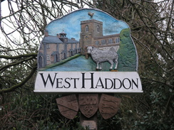
I put myself on autopilot and soon found myself entering the outskirts of West Haddon, with new houses being built on the right. I walked through the village and passed another pleasant-looking church, but as time was pressing I did not dawdle and pressed on out of the village. I had decided to take a footpath that would take me northeastwards, but after passing a new housing estate I was surprised to come across a new road that was not marked on the map. Steps led down to the road, and once carefully crossing it more led up the other side; when I got home I found out that this was the A428 West Haddon bypass, which had opened a little over a year before.
The footpath was muddy underfoot in places as it took me on across fields, and after diving down into a little dip after a barn it climbed up slowly towards White Horse Farm, where a couple of riders were brushing down their horses after a ride. Another very short stretch of path took me past a sign asking walkers to close the gate - a difficult task as the gate in question was lying down on the ground nearby.
Once the footpath ended a long road walk took me northwards back towards Cold Ashby, and I was surprised to find that the road was busier than I expected. Fortunately the verges were wide, and it proved easy to step out of the way as I walked along back towards the village. I finally got back to my car about half an hour earlier than I expected, and as I took some more photographs of the church I could look back on what had been a very enjoyable day's stroll.
 |
 |
|
 |
Directions
This walk starts off from the church in Cold Ashby. Leave the church and head north uphill along the lane northwards to a road junction by the village pub, and then turn left to start heading westwards through the village along Main Street. When this curves around to the left head straight on along Stane Road as it heads westwards for a little over a mile. Shortly after the route pasts a large mast on the left turn left down a track; this heads southwards , passing a house on the left before heading steeply downhill to reach Honey Hill Farm. Here the track ends, and a footpath continues onwards southwards, crossing a golf course before descending down to reach a stream.
Cross the stream, and on the other side climb up a bank and continue along the footpath as it heads on southwards, initially with a hedge on the left. It continues roughly southwards, before cutting across to the left to cross a field diagonally and joining the end of a green track. Join this track and follow it as it heads southwards, passing a building on the right before ending at a surfaced track near a wall guarding Winwick Hall. Turn right along this track, and almost immediately turn left and continue following the wall as it reaches the main entrance into the hall. Shortly after this the road ends at a junction; head straight on, crossing a sip in the road before heading westwards along a road.
Fairly soon the road curves to the left and a minor road leads off straight on; turn left and follow the new road as it heads southwestwards. This passes Heygates before reaching a crossroads. Here continue straight on along the road for another kilometre until a sharp left-hand bend is reached. Just past the bend a footpath leads off to the right; join this footpath and follow it as it heads westwards across a field. It soon crosses a track and passes some ponds to the left and a cottage on the right, before continuing on, approaching a stream on the left. Another track is reached, and shortly after this the path turns to the left to cross a stream, before heading southwestwards to end at a track. Turn left along this track for a couple of yards until the A428 road is reached at Crick Wharf.
Turn right and follow the A28 road as it heads westwards for a short distance, crossing over a canal on a bridge before turning to the right to head towards a roundabout. Do not follow the road around the bend and instead head straight on along an old road westwards, which soon joins Main Road in Crick. Follow the road past a shop on the left towards the centre of the village. Take the first road to the left, The Marsh, which heads southwards before curving to the right to end at the High Street. At this road turn left and start following the road southwards out of the village; the road climbs upwards and then take the first road leading off to the left, Watford Road.
Follow Watford Road southeastwards for a few hundred yards; after a cottage on the right turn right down a track that descends to reach a bridge over the canal. Do not cross the bridge and instead descend down to the towpath, with the southern portal of Crick tunnel lying a few yards to the north. Head south down the canal towpath for a little under four miles until Norton Junction is reached, and then turn left along a surfaced road that runs alongside the Grand Union Canal for a quarter of a mile to Buckby Top Lock No. 7, which is right beside the A5 road.
Here leave the canal and turn left to walk north along the A5 for a few yards, before turning right to join a footpath that heads northeastwards across fields. The path crosses a stream before climbing up a bank across a field, before heading up to met some houses. Do not join any roads, but continue on along a path that runs between the houses, before it eventually ends at a minor road called Harbridges Lane. Follow this road on, as it soon curves to the right and then the left before it ends at a T-junction by a pub on the left in the village of Long Buckby.
Turn right and walk eastwards along the road for a hundred yards; when the road curves to the right turn left down Church Street, to pass the church on the left. When Church Street ends at a T-junction turn left to follow a road called The Banks northwards out of the village; it descends down into a little valley before curving sharply to the left to climb uphill northwards. The road passes Grange Farm before descending to cross a stream. A kilometre further on the road passes Foxhill, and another kilometre further on Watford Road comes in from the left. Head straight on into the centre of West Haddon, as the road ends at the old A428 road in the village.
At the junction turn right to follow the main road through the village, passing the church on the left. When the road curves sharply to the right after a couple of hundred yards, continue straight on up Guilsborough Road. Head on along this road northeastwards until the end of the houses is reached on the left, and then turn left up a footpath that squeezes between houses on the left and a fence on the right. After about fifty yards the footpath turns right to head away from the houses along a field boundary on the left. After a short distance some steps lead down to the West Haddon bypass; carefully cross this road and climb up the steps on the other side to rejoin the footpath. This immediately passes a barn quickly falling into ruin, and then heads across fields, along an easy to follow path.
The path eventually reaches another barn, and skirts the side of this before descending down into small dip and climbing up the other side, to head northeastwards towards White Hore Farm. The path passes the farm, crossing a track before continuing northeastwards across another field to end at a road. At the road turn left, and start following it as it heads northwards for a little under two miles, until it eventually reaches the village of Cold Ashby. In the village the road curves around to the right and becomes Main Street; follow it eastwards and then turn right at the pub to descend for a few yards to the village pub, where this walk ends.
Distances
| From | To | Distance (m) | Ascent (ft) | Descent (ft) |
|---|---|---|---|---|
| Cold Ashby church | Crick | 5.8 | 328 | 567 |
| Crick | Norton Junction | 5.3 | 236 | 291 |
| Norton Junction | West Haddon | 5.1 | 509 | 311 |
| West Haddon | Cold Ashby church | 3.7 | 243 | 147 |
This makes a total distance of 19.9 miles, with 1316 feet of ascent and 1316 feet of descent.
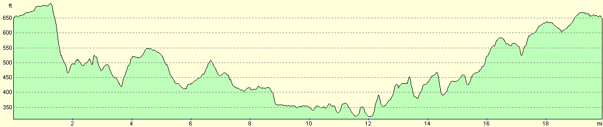
For more information on profiles, ascents and descents, see this page
Disclaimer
Please note that I take no responsibility for anything that may happen when following these directions. If you intend to follow this route, then please use the relevant maps and check the route out before you go out. As always when walking, use common sense and you should be fine.
If you find any information on any of these routes that is inaccurate, or you wish to add anything, then please email me.
All images on this site are © of the author. Any reproduction, retransmissions, or republication of all or part of any document found on this site is expressly prohibited, unless the author has explicitly granted its prior written consent to so reproduce, retransmit, or republish the material. All other rights reserved.
Although this site includes links providing convenient direct access to other Internet sites, I do not endorse, approve, certify or make warranties or representations as to the accuracy of the information on these sites.
And finally, enjoy your walking!
Nearby walks
| # | Title | Walk length (miles) |
|---|---|---|
| 137 | Market Harborough to Northampton | 18.3 |
| 158 | Bugbrooke to Braunston | 15.1 |
| 162 | Braunston to Leamington Spa | 16.6 |
|
|

|