Walk #756: A circular walk from Thetford to Brandon
 |
 |
|
General Data
| Date Walked | 14/01/2007 |
| County | Norfolk, Suffolk |
| Start Location | Thetford Station |
| End Location | Thetford Station |
| Start time | 08.50 |
| End time | 15.45 |
| Distance | 20.6 miles |
| Description | This was a pleasant circular walk to the northwest of Thetford, following roads, forest tracks and riverside footpaths. |
| Pack | Today I carried my 30-litre Karrimor rucksack filled with my waterproofs, two litres of water, and various other odds and ends. |
| Condition | I feel fine after this walk, and aside from a little discomfort in my left knee I had no significant problems. |
| Weather | The day was generally sunny, with only wispy clouds overhead for much of the day. It was quite mild for the time of year, although there was a fairly chilly breeze at times. |
| OS map | Landranger number 144 (Thetford & Diss, Breckland & Wymondham) |
 |
 |
|
 |
 |
|
Map of the walk
Maps courtesy of Google Maps. Route for indicative purposes only, and may have been plotted after the walk. Please let me have comments on what you think of this new format. For a detailed table of timings for this walk, please see the table file.
 |
 |
|
 |
 |
|
Notes
I did not fancy doing a long drive today, so I had a look in my file of planned walks and eventually picked one around Thetford, which is about forty-five minutes away up the A11. It was a good drive, as I would expect early on a Sunday morning, and I parked up in the car park at Thetford station earlier than I expected. After paying the one pound fifty for the day's car parking charge, I got my kit together and started the walk, heading down Station Road before stopping off at a Newsagent's for a bar of chocolate.
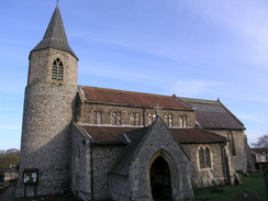
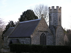
The next stretch of walk took me north towards Croxton, crossing the railway line on a bridge before passing under the dual carriageway of the A11. The road was surprisingly busy, and it was relief when it quietened down as I reached Croxton church, which is a superb example of a round-towered church. I took a few photographs of this before continuing on along the road through the pretty village.
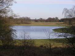
At the northern end of the village a road took me northeastwards, soon entering a patch of woodland that kept the chilly wind off me. At one point there were a couple of large circular depressions on the left, which looked like they could be shell holes from bombs - however surely they would have been filled in since the Second World War? Four joggers passed me before I reached the next junction, where I started a long road walk westwards. Immediately to the right there was a pretty lake, the view offset by the warning signs telling people to keep out from the military training area.
Immediately after this to the left was the Devil's Punchbowl; I was tempted to go and have a look at this, but as the day was early I decided to continue on along the road instead.
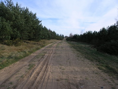
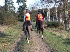
The next three miles took me along a road through woodland, passing the curiously-named New Buildings (which did not look new) before reaching the A134 road. N the other side a signpost marked the start of Harland Drove, a wide track that would take me westwards for the next few miles. The first few hundred yards of the drove was packed with horse boxes, with a large clearing to the right also being filled with four wheel drive cars and horse boxes. Associated with these were horses and ponies the riders of which were all wearing orange bibs with black numbers on them. I said hello to a couple of riders as I headed on along the track, unaware of how often I would see the riders during the day.
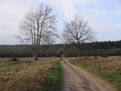
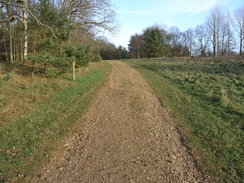
Trees surrounded the drove, and this made it a very pleasant walk, made easier by the fact that absolutely no navigational skill was required. A few horse riders passed me in the opposite direction as the track climbed and fell westwards; at one point there was a strange whooshing noise audible through the trees, and it took me a few seconds to realise that the sounds was from a train on the railway line a short distance to the south.
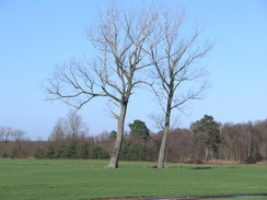
The drove ended abruptly at a main road, as did the surrounding trees, and a short stretch of road took me on westwards past fields and a solitary tumulus standing alone in a field. When this road ended I took a road that would lead me south into Brandon, and I was surprised by how busy this road turned out to be. Fortunately there was a pavement beside the road that made the journey safer, and in places this was being renovated, with the top layer of tarmac yet to be applied along a long stretch.
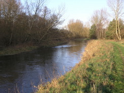
The road crossed a level crossing near Brandon Station, before I followed a main road south into the village. There were a couple of quite imposing buildings on the left - one of which was a hotel - and I studied these before I reached the bridge over the River Little Ouse. I took a few photographs from the bridge before considering about the route that I would take next. On a previous walk I had followed Hereward Way eastwards from the town and I recalled that that had been an enjoyable stroll, but this time I decided to follow a footpath along the river bank instead.
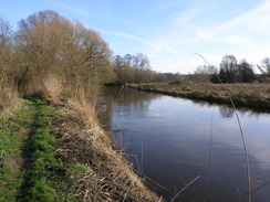
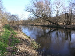
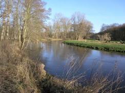
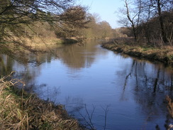
This turned out to be a very good decision, as after the path passed a landing stage marking the navigable limit of the river a lovely, if slightly overgrown, walk ensued. The pat followed the rover as it wound around a series of little bends, and each of these gave me good views down the river. This led to me stopping regularly to take photographs, but I did not mind my slow progress as it was the nest stretch of path that I have done for weeks. I did not want it to end, and it was a pity when the path ended at a bridge over the river immediately to the north of Santon Downham.
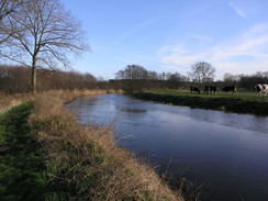
I decided to follow the road eastwards towards the little hamlet of Santon, and I was surprised how busy the little single-lane road was with cars. I passed a field with some Highland Cows in before reaching a large car park on the left - obviously the destination of all the cars. A short distance beyond the car park the Hereward way rejoined from a footbridge on the right, and for the rest of the day I would be walking along a path that I had done before in 2002.
Santon Church is small but pretty, but I did not delay for long and headed under the cattle creep under the railway line to join the forestry path that would take me eastwards. The track climbed up to the site of an old church, and as I passed this a couple of riders overtook me, wearing the orange bibs that I had seen earlier in the day. It was then that I noticed that my GPS batteries had run out, and for the first time for this new GPS I had to change the batteries - they are certainly lasting longer than my old ones. However as I did so the backplate that covers the battery compartment flew out of my hands and into the vegetation beside the path, and I ended up on my hands and knees for a few minutes before I eventually found it a few yards away.
The track ended at the A134, and a wide verge allowed me to safely walk along this for a short distance before turning down another track that led under the railway line into a large area of open ground. A child was roaring around on a mini motorbike, watched on proudly by his father, and as I walked towards the large factory (the site of the Fison's fertiliser plant) he came roaring past me, seemingly enjoying himself.
A concessionary footpath squeezed between the fence and the river, and just before I reached the end of this path some motorbikes and a quadbike came roaring past me, showering my trousers with mud as I stepped to one side to let them past. The area of ground to the south of the factory was a sandy waste ground with many tracks across it, but it proved easy to take the correct path that headed south with the river a short distance away to the west. At one stage there was a large sand berm that had been bulldozed into position, and this included the remains of a burnt-out car that had also been swept up.
Once past the berm the path entered some woodland, and although some of this had been cleared it was still a pleasant walk. The motorbikes roared past me once again, and this time I made sure that I was well off the path before they passed me, and this time I did not get muddy. Eventually the path headed back towards the river bank, and I followed this south towards the Abbey Heath weir. The sun was starting to get lower in the sky as I walked, and was annoyingly coming straight into my eyes, which was a shame as the riverside walk was particularly pleasant.
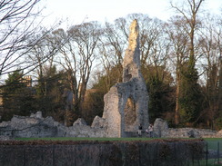
It was therefore a relief when the river turned to head eastwards, although it soon became more urban as it passed a lake on the left and plunged under the A11. On the other side of the bridge the scene was more urban with houses on either side of the river, but the ones one the left soon ended and a green area headed on. A couple of footbridges were passed before the path eventually reached a road bridge over the river, and I joined a road here to started the walk back through Thetford to the railway station. I ignored the spectacular ruins of the Priory as I had visited these a month or so before on another walk, and instead steadily strolled on towards the station and the end of the walk, happy having completed a particularly pleasant walk.
 |
 |
|
 |
 |
|
Directions
This walk starts off from Thetford railway station. Leave the station and walk southeastwards down Station Road for a few hundred yards until it ends at a T-junction with another road. Turn left along this road for a few yards, and then almost immediately turn left to start heading northwards along Croxton Road, which climbs to cross the railway line on a bridge, immediately after which is a main road. Cross this road, and then continue on along Croxton Road as it slowly climbs out of Thetford.
The road passes under the A11 after a mile, and continues on northwards for about a miles, entering Croxton and passing the church on the right before leaving the village. When a road junction is reached at the northern end of the village, turn right and follow this road as it heads northeastwards for about a mile and a half through some woodland. When another road junction is reached turn left, to start following another road westwards, passing a lake on the right and the Devil's Punchbowl on the left; after a mile another road junction is reached near New Buildings.
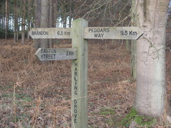
Continue straight on at this junction, and head westwards along a road for a little under two miles, passing between trees on both sides, until the road ends at the A134 main road. Carefully cross the A134, and continue straight on westwards along a track called Harland Drove, which is easy to follow as it heads almost directly westwards for a little over three miles, before the drove eventually end at the A1065 to the north of Brandon.
Carefully cross the main road and continue on westwards along a minor road for about half a mile towards Weeting; when the road ends at a junction turn left and start walking southwards for a kilometre along a surprisingly busy road, which has a pavement beside it, before it ends at the A1065 road immediately to the north of Brandon. Turn right and start following the main road southwards, as it crosses a railway line immediately to the west of the railway line. After a couple of hundred yards the road crosses the River Little Ouse on a bridge; just before the bridge is reached turn left down a road for a few yards before taking a footpath that heads off to the right, heading southwards for a short distance to reach the northern bank of the river.
Follow the footpath that runs along the northern bank of the river for a little under three miles, until a bridge over the river is reached at Santon Downham. Here turn left to follow a road northeastwards for a hundred yards; before the railway line is reached turn right along another road that leads southeastwards for over half a mile, passing a car park on the left before reaching the tiny Santon Church.
At the church join St Edmund Way, which will be followed all the way to Thetford, as it heads to the left, passing through a small bridge under the railway line; on the other side of the bridge turn right along a track that heads eastwards through the forest, with the railway line down below to the right. The track ends at the A134 road; turn right to head southeastwards down the A134 for a short distance before turning right down another track, signposted for a Cub and Scout camp.
When the track immediately forms take the left-hand fork, and head under a low bridge under the railway line to reach a large expanse of ground. Walk down towards the river, and then turn left to walk along the ground towards a large factory. Head to the right of the factory along a footpath that squeezes between the river and the factory grounds, and on the other side cross some waste ground, with the river out of sight below to the right. The path soon leaves the waste ground and enters woodland, plunging southwards through the trees. After half a mile amongst the trees, the path turns slightly right to meet the river bank, and continues south with the river in close company to the right to reach Abbey Heath Weir.
The river continues to twist around, eventually passing some lakes on the left and passing under the A11 dual carriageway bridge to reach the outskirts of Thetford. Continue along the path as it settles on a more easterly course for about a mile from the A11; when the surfaced path ends head on along the grass with the river on the right until a large road bridge is reached near the ruins of the priory. Here turn left to join London Road which runs over the bridge, and head northwards along the road, which soon curves to the right. After a short distance turn left up Station Road, and follow this up to the railway station, where this walk ends.
Distances
| From | To | Distance (m) | Ascent (ft) | Descent (ft) |
|---|---|---|---|---|
| Thetford station | Croxton | 2.5 | 130 | 102 |
| Croxton | Brandon | 8.8 | 202 | 302 |
| Brandon | Thetford station | 9.3 | 239 | 167 |
This makes a total distance of 20.6 miles, with 571 feet of ascent and 571 feet of descent.
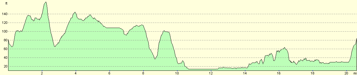
For more information on profiles, ascents and descents, see this page
 |
 |
|
Disclaimer
Please note that I take no responsibility for anything that may happen when following these directions. If you intend to follow this route, then please use the relevant maps and check the route out before you go out. As always when walking, use common sense and you should be fine.
If you find any information on any of these routes that is inaccurate, or you wish to add anything, then please email me.
All images on this site are © of the author. Any reproduction, retransmissions, or republication of all or part of any document found on this site is expressly prohibited, unless the author has explicitly granted its prior written consent to so reproduce, retransmit, or republish the material. All other rights reserved.
Although this site includes links providing convenient direct access to other Internet sites, I do not endorse, approve, certify or make warranties or representations as to the accuracy of the information on these sites.
And finally, enjoy your walking!
Nearby walks
| # | Title | Walk length (miles) |
|---|---|---|
| 207 | Shippea Hill to Thetford | 20.2 |
| 208 | Thetford to Attleborough | 16.9 |
| 212 | Bury St Edmunds to Thetford | 17.8 |
|
|

|