Walk #757: A circular walk from Maidwell
 |
 |
|
General Data
| Date Walked | 17/02/2007 |
| County | Northamptonshire |
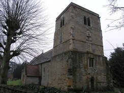
| Start Location | Maidwell Church |
| End Location | Maidwell Church |
| Start time | 09.08 |
| End time | 16.13 |
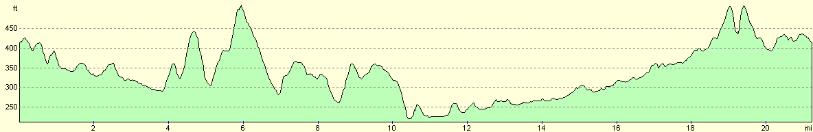
| Distance | 21.4 miles |
| Description | This was a very pleasant walk following footpaths and tracks south before using an old railway trackbed to head back north to visit the Kelmarsh tunnels. |
| Pack | Today I carried my 30-litre Karrimor rucksack, filled with waterproofs, a book and other odds and ends. |
| Condition | I am tired but feel absolutely fine after this walk. |
| Weather | There was low cloud for much of the day, but at times this lifted slightly, revealing patches of blue sky. It was not too cold, although there was a bit of a chilly wind. |
| OS map | Landranger number 141 (Kettering, Corby & surrounding area) and Landranger number 152 (Northampton & Milton Keynes) |
 |
 |
|
 |
 |
|
Map of the walk
Maps courtesy of Google Maps. Route for indicative purposes only, and may have been plotted after the walk. Please let me have comments on what you think of this new format. For a detailed table of timings for this walk, please see the table file.
 |
 |
|
 |
 |
|
Notes
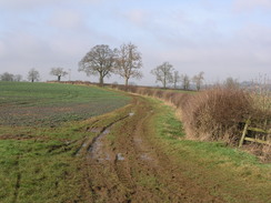
This was a walk that I had planned for some time, and as I did not fancy driving too far I dusted it off and headed out early this morning along the A14. It did not take me to long to reach Maidwell, and I parked my car neatly outside the church and got my kit together ready for the walk. For some reason my legs were initially stiff as I followed the road down to the main road, although they eased off as I walked off along the next road. To the left there was an old fish pond, the dam wall obviously breached and grassed over; it is unusual to see one of these and I tried to imagine what it would have looked like when full.
At Blueberry Lodge the road ended and a muddy track took me on southwestwards; as I walked I was met by a cyclists and we chatted for a while until the top of the hill was reached, when he sped off ahead of me. To the right on the descent there was some obvious parkland, and I could just make out Cottesbrooke Hall in the distance. A fairly boring stretch of footpath came next, following a stream for a time before I reached Creaton.
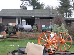
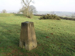
In Creaton I stopped off in the shop to buy a few bits and bobs before continuing on uphill past the church. Once across the main road I was surprised to see what looked like a steam boiler over a fence to the left, and a closer look showed me that there were two steam traction engine under restoration, and it looked like a really good job was being made of them. The path was muddy in places as it headed down towards a stream, and a nice ascent took me up to another road, where I made a diversion off to visit a nearby trig pillar, from where there were some decent views northwards.
A long stretch of road walking followed, taking me firstly towards Teeton and then further southwards. On the way I was passed by several horseboxes, and when I came across an attractive woman readying a horse she told me that they were all preparing for a hunt. As I walked on there were even more horses, and eventually the road became full of horses and riders, heading out from the farm at Holdenby North Lodge. I said hello to every group of riders, and all replied back to me, smiling, as is usually the case when I meet hunters.
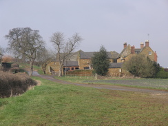
At the next road junction there was a great deal of rubber on the ground and signs that there had been a recent car crash, but I soon left this road and a pleasant bridleway took me down across fields to Church Brampton and the A5199 road. There were some pleasant stone houses by the road, but I took a smaller road that headed downhill to reach Brampton station and the Northampton and Lamport railway. The main station building is now a pub, and although it looked tempting I crossed the line to reach the footpath on the other side.
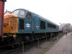
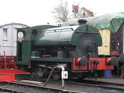
The line was full of interesting things to see, including a large Peak locomotive 45118 'The Royal Artilleryman' and class 25 25035 'Castell Dinas Bran' - a place near Llangollen I hope to see when I do Offa's Dyke later in the year. It was pleasant to walk past all of the history, but soon the short running line ended by a pile of concrete sleepers and the path continued northwards. The old railway line was simplicity itself to follow, and there were a few other people about as well, despite it being early in the year. Several level crossings were passed, until eventually an ornate metal footbridge without steps was reached to the east of Maidwell.
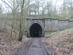
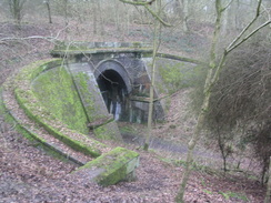
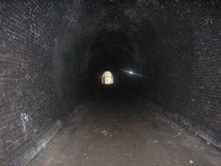
Here I could have headed back to the village and my car, but as I was still feeling fit I decided to continue on along the old railway line to visit the southernmost of the two tunnels. years before I had walked along the line as a walk from Market Harboorugh to Northampton, and I remembered the pleasant but eerie experience of walking through the tunnels. After about a mile and a half the small bridge under the A14 was reached, and a little further on I could see the portal of a tunnel. There are actually two single-track tunnels side-by-side, and the path passes through the easternmost of them. It got dark as soon as I came in, and as I appeared to be on my own I started singing, enjoying the echoing effect through the tunnel.
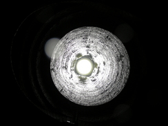
Halfway through the tunnel there was a ventilation shaft overhead, and when I had walked the line previously I had managed to get a good photograph up the shaft. This time, however, there was water pouring down the shaft that prevented me from taking any photos, a sign of all the rain that there had been recently. The illumination from my torch was rather weak, and I occasionally used my camera flash to show up details in the brickwork of the tunnel.
Once I reached the northern portal I climbed up and carefully crossed over to the top of the portal of the western tunnel. I was tempted to descend and go back via that tunnel, but my torch was not very strong and I decided to go back the way that I came. On the way I started to howl, a sound that echoed gloriously around the interior of the tunnel, and only after I had finished did I realise that a family had entered the tunnel a few minutes behind me!
The journey back south from the tunnel was fairly boring, especially as I was getting tired, but I did not have long before I headed off along a bridleway that took me swiftly back towards Maidwell. Dusk was just starting to fall as I arrived, fairly happy at having completed yet another day's walk.
 |
 |
|
 |
 |
|
Directions
This walk starts off at the church in Maidwell,and for the first few miles follows the Macmillan Way. Leave the church and head west slightly downhill towards and across the A508 road. On the other side head west along a minor road that descends to cross a stream before climbing once again, turning to head southwest towards Blueberry Lodge. Here the road ends, but a muddy track continues on southwestwards, passing some woodland before slowly descending down to a road
Cross the road and once on the other side head south along a footpath; this turns to the right to cross a stream before heading southwestwards across a field; it then follows another stream for a while before turning slightly to the right to head slightly south of westwards, soon dropping down a hill to meet a road outside Creaton. Head straight on along this road into the village. Continue along this road and then turn left to head uphill, passing a shop on the right and a church on the left before ending at the A50.
Carefully cross the A5 and, once on the other side had straight on along a footpath. This heads downhill southwestwards along a green track towards a stream, crossing the stream before climbing up the other side, ending at a road near a trig pillar to the south of Pastures Farm. Turn left along this road and follow it downhill to the southeast, and at the first junction continue on for a few yards as the road curves to the left and then take a road off to the right. This road then heads southwards, descending slightly to cross a stream before rising up the other side to reach Holdenby North Lodge.
At the lodge the road turns sharply to the left to head eastwards; continue along it as a road joins from the right and then on for a hundred yards until the road curves sharply to the left. Here turn right and join a bridleway that follows a fairly indistinct track towards Cank Farm. At the farm a track is joined, but after a short distance this turns to the left and the bridleway continues on, taking a more southeasterly course as it heads uphill. It passes to the west of Sander's Covert before turning slightly to the left, passing to the right of another area of woodland and crossing a track immediately to the north of Brampton Hall.
The bridleway soon crosses another track before ending at a road in Chapel Brampton. Head straight on along this minor road until it ends at a T-junction and then turn left for a few yards to reach the A5199. Cross the main road, and on the other side follow the road eastwards downhill as it crosses a river and reaches a car park by a pub and preserved railway. Go through the car park and cross the platforms to reach the footpath on the eastern side of the line.
Turn left and start walking northwards alongside the line, heading away from the station and the bridge. After half a mile the railway line ends and the footpath continues on; follow it as it heads northwards for about eight miles, when the path passes under the A14. Continue on for a few hundred yards to the southern end of Kelmarsh tunnel and then on through the tunnel before turning back round and heading back through the tunnel.
Pass under the A14 once again and walk on southwards for about half a kilometer until a bridleway crossing is reached. Here turn right and follow a bridleway southwestwards across a field before turning left to head south along a track. This track heads south for about a kilometer before reaching a road; head straight on down this road for another few hundred yards until Maidwell church and the end of the walk is reached.
Distances
| From | To | Distance (m) | Ascent (ft) | Descent (ft) |
|---|---|---|---|---|
| Maidwell church | A5199 in Creaton | 4.7 | 327 | 295 |
| A5199 in Creaton | Brampton station | 6.0 | 498 | 682 |
| Brampton station | North portal of Kelmarsh tunnel | 8.7 | 448 | 285 |
| North portal of Kelmarsh tunnel | Maidwell church | 2.0 | 156 | 167 |
This makes a total distance of 21.4 miles, with 1429 feet of ascent and 1429 feet of descent.
For more information on profiles, ascents and descents, see this page
 |
Disclaimer
Please note that I take no responsibility for anything that may happen when following these directions. If you intend to follow this route, then please use the relevant maps and check the route out before you go out. As always when walking, use common sense and you should be fine.
If you find any information on any of these routes that is inaccurate, or you wish to add anything, then please email me.
All images on this site are © of the author. Any reproduction, retransmissions, or republication of all or part of any document found on this site is expressly prohibited, unless the author has explicitly granted its prior written consent to so reproduce, retransmit, or republish the material. All other rights reserved.
Although this site includes links providing convenient direct access to other Internet sites, I do not endorse, approve, certify or make warranties or representations as to the accuracy of the information on these sites.
And finally, enjoy your walking!
Nearby walks
| # | Title | Walk length (miles) |
|---|---|---|
| 137 | Market Harborough to Northampton | 18.3 |
| 138 | Market Harborough to Leicester | 17.7 |
| 158 | Bugbrooke to Braunston | 15.1 |
|
|

|