Walk #101: Castleton circular via Rushup Edge and Edale
 |
 |
|
General Data
| Date Walked | 23/07/2000 |
| County | Derbyshire |
| Start Location | Castleton |
| End Location | Castleton |
| Start time | 08.40 |
| End time | 14.55 |
| Distance | 12.5 miles |
| Description | This was a beautiful circular walk taking in a couple of villages and a couple of spectacular ridge walks. |
| Pack | Today I carried a full pack, but with no tent. |
| Condition | I had no major problems today at all. I was slightly fatigued at the end of the walk, but am otherwise okay despite the fact that there was a fair amount of climbing done during the day. I am still not at peak fitness after my bout of tonsillitis; however I feel much better than I did whilst doing a walk last week. I had no problems with my ankle or my back, despite carrying what was nearly a full Pennine-Way spec pack. |
| Weather | The day started off cloudy, and as I drove north from Ashbourne I started driving into the cloud. On arrival at Castleton the weather did not look too promising - the top of Mam Tor was not visible due to cloud, and the Hollins Cross Ridge was also obscured. I started climbing into the mist, but by the time I reached Rushup Edge it was lifting, and what followed was a day of lovely bright sunshine. Even the winds lowered considerably during the afternoon. |
| OS map | Outdoor Leisure number 1 (The Peak District - Dark Peak Area) |
 |
Map of the walk
Maps courtesy of Google Maps. Route for indicative purposes only, and may have been plotted after the walk. Please let me have comments on what you think of this new format. For a detailed table of timings for this walk, please see the table file.
Notes
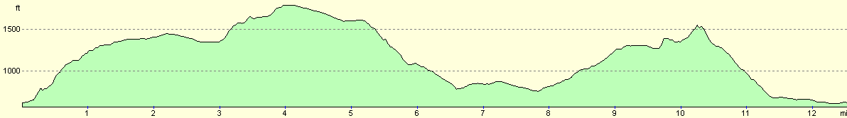
This was a superb day's walking. I had expected it to be quite hard as the route that I had planned involved a fair amount of climbing (around 2400 feet climb and fall). It was not as bad as I had feared, however, and I extended the end of the walk by walking west along the ridge from Hollins Cross to Lose Hill instead of dropping straight down into Castleton.
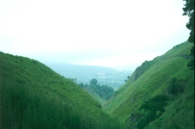
When I first arrived at Castleton the weather was highly non-optimal, with low cloud covering the hills around the skyline. The situation was much the same as I tackled the climb up Cave Dale, and along the walk to the pass between Rushup Edge and Mam Tor. However during the descent from Rushup Edge to Barber Booth the weather markedly improved, until eventually there was glorious sunshine.
Because I reached Edale before midday and I did not have much more walking to do that day, I decided to stop off at the hikers café in Edale that is to the south side of the station. I spent fifty minutes in the salubrious surroundings, and had two cups of tea and a large full English breakfast. It is unusual for me to have such a large meal whilst I am on a walk, but in this case it was much appreciated as I had forgotten to bring any food with me.
When I was climbing out of Edale towards Hollins Cross I became aware of an orange helicopter flying overhead from the Edale direction. It set down on the ridge and quickly took off again. When I reached Hollins Cross and started the climb towards Backtor I saw it taking off again from the valley floor near Castleton. I later discovered from a couple of walkers that a mountain biker had been attempting to descend the very steep and stony slope of Backtor when he had fallen off, badly gashing his knee. Apparently they decided to call in a rescue helicopter to life him off. Yet again I thank the lord for the rescue services.
Finishing off a walk at 14.55 seems strange in summer - the afternoon is only halfway through and there are still many hours of daylight left. I had a strong urge to leave my pack at the car and climb up to Mam Tor via the collapsed section of the A625 at the foot of Mam Tor, but I decided against it as I had other things to do whilst I was in the area. I will return sometime soon to do that particular walk.
Directions
From the car park in Castleton head south up the steep climb of Cave Dale following the Limestone Way. When the slope starts flattening out a stile takes you across a track near the ruins of the old Hazard Mine. Turn right down this track, and then shortly afterwards turn right down another track that takes you past northwestwards Rowter Farm and up to the B6061. Cross the B6061 and head across Windy Knoll to the A625. Cross the A625 and tackle the steep climb up the pass between Mam Tor to the east and Rushup Edge to the west.
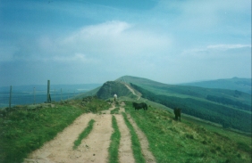
Ignore the path to the right that leads up to the summit of Mam Tor and join the road. Follow the road northwards until it starts to descend. A stile to the left takes you up onto the top of Rushup Edge. Follow the Edge westwards for about a mile and a half past Lord's Seat until you reach a junction with a path that heads northwards. Join this track, known as Chapel Gate, and follow it as it veers to the northeast and descends down towards Barber Booth. There are some magnificent views on the descent to the north over the valley to Kinder.
At the end of the steep section of descent a path near a sheepfold heads off straight on to the north-east towards Barber Booth. Alternatively you can do as I did and stay on the Chapel Gate Track until you come across a road, where Barber Booth is downhill to the left.
In Barber Booth follow the road as it swings around to the east towards Edale. Just before the end of the village a little road signposted for the Chapel heads off to the left. Follow this track, and almost immediately take a footpath that leads off to the right before turning to the north and crossing over the railway line. Shortly after the bridge the path turns to the right and crosses fields into Edale. When you reach the road in Edale turn right and head downhill towards the station.
Just pass the station the road ends at a T-junction. Turn right down the road towards Barber Booth, but quickly take the first left that uphill to the south past Hardenclough Farm. Shortly after the farm a track heads off to the right and bends towards Greenlands Farm. Just before the entrance to the farm a bridleway heads off to the left and climbs uphill towards Hollins Cross.
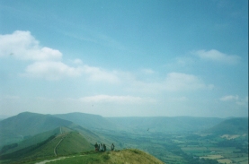
From Hollins Cross turn left and follow the ridge along Barker Bank, and then up the steep slope of Backtor Nook. Descend slightly and then climb again to reach the tumulus at the top of Lose Hill, the end of the ridge east from Mam Tor. Spend a little while savouring the delicious views around all points of the compass, from Mam Tor and Rushup Edge to the east, Kinder Scout to the north and Castleton and Hope to the south.
Descend from Lose Hill by the path to the southeast. When a wall is reached cross over it and head down the path towards Losehill Farm. Make a sharp right just after the farm and then head southwards across fields to Spring House Farm. Turn right and join a track that heads to the west past Losehill Hall. When the track turns sharply to the left continue straight on across fields to join another track. After a short while this track joins Hollowford Road, which can be turned down to the left to reach Castleton. When the A625 is reached in Castleton join it and head back towards the car park.
Distances
| From | To | Distance (m) | Ascent (ft) | Descent (ft) |
|---|---|---|---|---|
| Castleton | Start of Chapel Gate Track | 5.0 | 1362 | 384 |
| Start of Chapel Gate Track | Edale | 2.7 | 157 | 978 |
| Edale | Castleton | 4.8 | 955 | 1112 |
This makes a total distance of 12.5 miles, with 2474 feet of ascent and 2474 feet of descent.
For more information on profiles, ascents and descents, see this page
Accommodation
There are plenty of campsites and B&B's in both Castleton and Edale; however the area gets very busy in summer so it is vital to phone ahead in advance.
Transport
Edale has a railway station on the Manchester to Sheffield Hope Valley Line, with regular services running between the two cities. There is also an hourly summer weekend bus service running between the two villages.
Disclaimer
Please note that I take no responsibility for anything that may happen when following these directions. If you intend to follow this route, then please use the relevant maps and check the route out before you go out. As always when walking, use common sense and you should be fine.
If you find any information on any of these routes that is inaccurate, or you wish to add anything, then please email me.
All images on this site are © of the author. Any reproduction, retransmissions, or republication of all or part of any document found on this site is expressly prohibited, unless the author has explicitly granted its prior written consent to so reproduce, retransmit, or republish the material. All other rights reserved.
Although this site includes links providing convenient direct access to other Internet sites, I do not endorse, approve, certify or make warranties or representations as to the accuracy of the information on these sites.
And finally, enjoy your walking!
This walk was mentioned in the following routes:
| My sectional Land's End to John O'Groats walk |
Nearby walks
| # | Title | Walk length (miles) |
|---|---|---|
| 13 | Edale and Kinder Scout | 11.0 |
| 19 | Castleton circular via Lose Hill and Mam Tor | 7.7 |
| 23 | The Limestone Way from Pomeroy to Castleton | 14.0 |
|
|

|