Walk #206: Ely to Ramsey
 |
 |
|
 |
 |
|
General Data
| Date Walked | 17/07/2002 |
| County | Cambridgeshire |
| Start Location | Ely Station |
| End Location | Ramsey |
| Start time | 07.55 |
| End time | 16.42 |
| Distance | 24.9 miles |
| Description | This was a walk of two halves - a combination of footpaths, tracks and roads to get me to Chatteris, and a long road walk to get to Ramsey. The Fenland looked marvellous but dry in the summer sunshine. |
| Pack | I carried my 30-litre Hotrock rucksack which held a fleece, Psion 5, spare batteries, a book and a few other odds and ends. |
| Condition | I am fatigued after this walk, but this is hardly surprising considering the distance that I have walked today. I have one blister on the fourth toe on my right foot, but aside from this I am remarkably trouble-free. My knees and shoulders gave me no pain at any time, which is a change from the last few walks where I have had the odd twinge. |
| Weather | The weather today was very hot, and started off with bright sunshine with only a few clouds. As the day went on the wind picked up slightly and it started to cloud over more. During these periods the walking was actually quite pleasant, but for the short periods when the sun came out I felt very hot. There was no sign of any rain, which was a relief. |
| OS map | Landranger number 143 (Ely & Wisbech, Downham Market) and Landranger number 142 (Peterborough, Market Deeping & Chatteris) |
 |
 |
|
 |
 |
|
Map of the walk
Maps courtesy of Google Maps. Route for indicative purposes only, and may have been plotted after the walk. Please let me have comments on what you think of this new format. For a detailed table of timings for this walk, please see the table file.
Notes
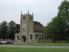
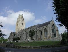
Ely is probably my favourite place in Cambridgeshire, and so it was with joy that I walked the first part of this walk through the town. It is hard to throw a stone in the centre of Ely without hitting an old building. This is mainly due to the fact that the town is home to two old institutions - the cathedral and the diocese of Ely, and the Kings School. When I set off I was unsure of exactly where I was going to walk to; Chatteris was my first target at fifteen miles, but I thought that I may be able to extend the walk to Ramsey, another ten miles further on. I did not let this bother me and just concentrated on getting to Chatteris.
One of the first parts of the walk from the A10(T) to the west of Ely towards Witchford was along a bridleway that was clearly marked on the map. The track was very obvious on the ground but was quite overgrown, and at first I thought that it may be an old railway trackbed as ditches were clearly visible through the undergrowth on either side. However a quick study of the map showed that it was the old road leading from Ely to Witchford, which has been replaced with the A142 a little distance to the south.
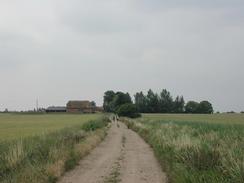
The Fens looked lovely in the sun, and all the footpaths and tracks were firm with no signs of any mud to make the going hard. This was fortunate as I was doing the entire walk in my trainers as I had decided that the road walking would be too tough on my feet if I had worn my boots. The sky above me was expansive, with views available from horizon to horizon. In the distance machines could occasionally be seen at work, watering fields or harvesting crops.
I passed one area of Fenland near North Farm where there appeared to be bowling-green perfect lawns. I wondered why they were growing grass in what is the grain basked of Britain, when I saw a large lawnmower (the same sort that councils use to mow school playing fields) pass me down the track. It is when I saw this that I realised that the farm must be growing grass to be used as turf. This also led me to wonder how much taking an inch worth of soil off the ground each time they harvested the turf must be shrinking the ground - it is already very near sea level. I had silly visions of the whole area being underwater due to over-active turfing!
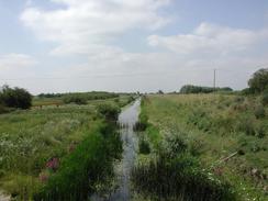
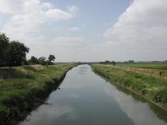
The choice of routes between Ely and Chatteris was few due to the problems of getting over the Hundred Foot Washes, which is the area of land between the Old and New Bedford Rivers. There are only three road crossing points of this area for the thirty miles between Earith in the southwest and Downham Market to the northeast, and two of these regularly flood in winter and become impassable. The whole area between the two rivers acts as a massive flood plain in winter, relieving the pressure on the outfalls of the Rivers Ouse and Nene. The area of wetland this produces - about thirty miles long by a hundred yards wide - is ideal for bird life, and there is a wildfowl refuge a little to the northeast in Welney.
I had my lunch break at the George Hotel in Chatteris, where I had a quick pint followed by a pint of orange and lemonade to refresh me. By this time I had walked over fifteen miles and I did not feel any the worse for it, and so I decided to extend the walk for another ten miles by walking into Ramsey, and thus linking up two places that I had already walked to.
The walk alongside the forty-foot drain (also known as Vermuyden's Drain) was quite long and monotonous, without much to really distinguish it. Walking along straight roads for such a distance can be quite boring, and unfortunately this was no exception.
I stopped for a short rest by the farm buildings at Hollow Heap Farm so that I could get my drinks bottle out. I sat down on the dusty ground and I noticed that my phone was ringing. It was Sam, who had tried me ten times in half an hour and had been getting very worried about me. Unfortunately my mobile was in my rucksack as my shorts did not have enough pockets to carry it, and I had not heard it over the sound of my walkman. I apologised to her and told her that I was safe, and at the end of the walk I bought her a bunch of flowers to say sorry and thank you for her picking me up.
Directions
This walk starts off at Ely Station. Walk through the car park and meet the A142 Station Road. Turn left and use the pedestrian crossing to reach the other, northern, side of the road. A short distance on from the crossing is a roundabout, which can be crossed over. Continue straight on and head uphill along Station Road, which soon becomes Back Hill. At a junction turn left along Barton Road, and when this road ends at a T-junction turn right down parade Lane and then left down Silver Street. At a crossroads turn left and then right down West End for a short distance. Take the first road that leads off to the left, St Johns Road. This road heads past a school and some new housing before ending at a ninety degree bend to the right. At this bend continue straight on down a green lane until the A10(T) is reached.
Cross the A10(T) and head south-westwards along a bridleway directly opposite which runs along a continuation of the green lane that was on the other side of the A10(T). After a kilometre this meets the A142 road, which has a footpath and cycle path running alongside it. Turn right along the A142 and head westwards for a few hundred metres until a slip road to the left to Witchford is met. Head down this road as it becomes Main Street and heads into the village of Witchford.
Just before the church in Witchford is met turn left down Grunty Fen Road. After just under a kilometre turn right to head south-westwards along Pools Road. After a mile this road turns to the right to head westwards for a little over a kilometre. Once a junction to the right is met the road turns to the left to head south-westwards for a few hundred metres to the house at Red Roofs, where the road turns to the right to head north-westwards. At the next bend, where the road turns to head south-westwards once more, continue straight on along a bridleway that heads north-westwards along a green lane called Pingle Lane. A little over a kilometre later the road bridleway meets the A1421 road. Turn right along the road for a few yards and then turn left, to pass through a simple bar gate into an old piece of road. Head long this road and then turn left and right, to join a footpath that heads south-north-westwards for a kilometre alongside the New Cut Drain to meet a road on the eastern side of the village of Sutton-in-the-Hill.
Turn right down Station Road and follow is as it climbs and then turns left to head westwards into the village. At a junction opposite the church continue straight on along the High Street. After about half a kilometre this road meets up with the B1381 road, which can be continued straight on for nearly a kilometre until the junction with Bury Lane is met to the right. Take Bury lane as it descends to the northwest towards Sutton Gault. It then crosses the New Bedford River and becomes the Causeway, where a raised walkway can be used to cross the floodplains if the washes are flooded. On the other side of the causeway cross the Old Bedford Rover and continue straight on. At Broadpeice Farm the road turns left to head north-north-eastwards for a few hundred metres before turning left to head north-westwards along Fen Drove. When the road turns left to head westwards at North Farm turn right to head north up a bridleway that follows a wide, clear track called Short North Fen Drove across the Fens.
Follow the bridleway as it heads in a northerly direction for a mile. It then turns forty five degrees to the left to head northwest for a couple of kilometres across Horseley Fen before turning to the right to head northwards along Horseley Fen Drove for nearly a kilometre to meet the A142 road. Turn left and follow the A142 road north-westwards, using the pavement to avoid having to walk on the road. When the A142 road starts to curve to the right continue straight on along Wenny road and then East Park Street to meet the B1098 road in the centre of the town of Chatteris.
Continue north along the B1098 until it turns to the right to head eastwards. At this point continue straight on along the High Street and Bridge Street to meet a roundabout with the A412 and A141 roads to the north of the town. At the roundabout continue straight across to head north-westwards along Doddington Road for a mile until Leonard Childs Bridge over the Forty Foot drain is reached. Cross over the bridge and turn immediately left, to head westwards along Forty Foot Bank Road which runs on the northern side of the Forty Foot drain.
Follow Forty Foot Bank Road for a couple of miles until Puddock Bridge is reached on the left. At the bridge turn left to head south-south-westwards along Puddock Road (which after a while becomes single track road with passing places) for a couple of miles until a Ramsey Hollow road is met leading off to the right. Take this road as it heads south-north-westwards for a mile past Toll Farm. Shortly after it crosses Ash Drain the road ends at a T-junction with Ramsey Hollow Drove. Turn left and follow Ramsey Hollow Drove as it heads south-south-westwards for a little over a kilometre until a footpath leads off to the right along a track.
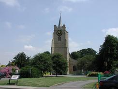
Take this footpath as it heads to Hollow Heap Farm, where it turns to the right to head northwards for a short distance before turning left to head westwards, all the time following the track. It then turns left and then immediately right, to result heading in a westerly direction before ending at a t-junction in the track. At the junction turn left to head south until the track ends by some school playing fields. From here the footpath heads southwards to meet a road, but I continued across the school playing fields and onto the Ramsey Sports centre. I then went down the driveway to meet Hollow Lane. One the lane is met, turn right and follow it until it ends at a T-junction with the B1096 road beside the remains of part of an abbey. Turn left down the B1096 for about a hundred metres before turning right down the B1040 Great Whyte Road, which is the centre of the town of Ramsey.
Distances
| From | To | Distance (m) | Ascent (ft) | Descent (ft) |
|---|---|---|---|---|
| Ely Station | Sutton-in-the-Hill | 7.8 | 207 | 148 |
| Sutton-in-the-Hill | Chatteris | 6.9 | 69 | 112 |
| Chatteris | Ramsey | 10.2 | 39 | 46 |
This makes a total distance of 24.9 miles, with 315 feet of ascent and 306 feet of descent.
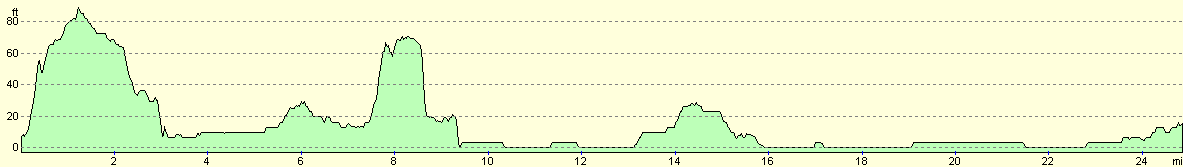
For more information on profiles, ascents and descents, see this page
Transport
My girlfriend dropped me off at Ely and picked me up from Ramsey, so I did not have to rely on public transport. There are fairly regular bus services from Ramsey to Peterborough, where trains can be caught back to Ely.
Disclaimer
Please note that I take no responsibility for anything that may happen when following these directions. If you intend to follow this route, then please use the relevant maps and check the route out before you go out. As always when walking, use common sense and you should be fine.
If you find any information on any of these routes that is inaccurate, or you wish to add anything, then please email me.
All images on this site are © of the author. Any reproduction, retransmissions, or republication of all or part of any document found on this site is expressly prohibited, unless the author has explicitly granted its prior written consent to so reproduce, retransmit, or republish the material. All other rights reserved.
Although this site includes links providing convenient direct access to other Internet sites, I do not endorse, approve, certify or make warranties or representations as to the accuracy of the information on these sites.
And finally, enjoy your walking!
Nearby walks
| # | Title | Walk length (miles) |
|---|---|---|
| 3 | Littleport to Downham Market | 14.0 |
| 7 | Waterbeach - Burwell - Swaffham - Waterbeach | 17.1 |
| 8 | Waterbeach to Newmarket | 17.5 |
|
|

|