Walk #748: Thames Path: Maidenhead to Shepperton
 |
 |
|
General Data
| Date Walked | 04/11/2006 |
| County | Berkshire, Buckinghamshire, Surrey |
| Start Location | Maidenhead station |
| End Location | Shepperton station |
| Start time | 08.42 |
| End time | 16.56 |
| Distance | 23.2 miles |
| Description | This was a long walk, following the Thames Path as it snakes southeastwards towards London. |
| Pack | Today I carried my 30-litre Karrimor rucksack filled with my waterproofs, two litres of water, and various other odds and ends. |
| Condition | I am relatively okay after this walk, the only problem being occasional discomfort from my right knee. |
| Weather | The day was bright and sunny with very few clouds in the sky. It started off cold, but warmed up as the ady went on, before the temperature dropped with the sun in the afternoon. |
| OS map | Landranger number 175 (Reading & Windsor, Henley-on-Thames & Bracknell) and Landranger number 176 (West London, Rickmansworth & Staines) |
 |
 |
|
 |
 |
|
Map of the walk
Maps courtesy of Google Maps. Route for indicative purposes only, and may have been plotted after the walk. Please let me have comments on what you think of this new format. For a detailed table of timings for this walk, please see the table file.
 |
 |
|
 |
 |
|
Notes
I wanted to walk the next stretch of the Thames Path today, from Maidenhead to Shepperton, but whilst planning the public transport looked as though it would be problematic. Eventually I decided to drive down to South Woodford Station, and then get the tube to Paddington, so that I could change onto a train for Maidenhead. This worked out quite well, and I reached Maidenhead about half an hour earlier than expected, which meant that I was on the path well before nine.
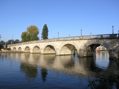
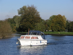
The first stretch was a retrace of my steps last week to reach the river, a walk of a mile through a fairly undistinguished part of the town; the only highlights being the building housing a branch of ARM PLC (a company which which I have had some connections in the past), and some old brick buildings on the left on the A4. Just before I reached the river there was a petrol station, and I nipped in to buy a packet of crisps and use the toilet. Afterwards, as I crossed Maidenhead Bridge, I was charmed to see three men in a little rowing boat on the river; I wondered if they were trying to reproduce apart of Jerome K Jerome's masterpiece.
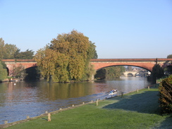
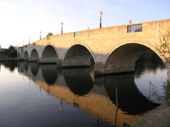
It was a relief to cross the river and rejoin the riverside path, as immediately the scenery became much better, including some lovely views back to the stone arches of the bridge, which carries the A4 across the river. The Trail followed a road as it headed south, soon reaching the red brick arches of one of Brunel's best masterpieces, the twin arches of which carries the Great Western Main Line to Bristol over the river. These are still, nearly 170 years after they were constructed, the flattest, shallowest brick arches in the world, each with a span of 128 feet and a rise of just 24 feet.
The controversial bridge was planned as Brunel wanted the gradients of the line to be as flat as possible, which led to the line being known as 'Brunel's Billiard Table'. Indeed, the arches were so shallow that people expected them to collapse as soon as the wooden centring was removed after construction. To outwardly placate these people, Brunel left the centering in place for a year whilst trains ran overhead; only at the end of the year did he admit that he had dropped the centering so in fact the bridge had been taking the load all the time! The fact that the bridge is still in use, and carries far greater loads than it was designed for, shows just some of Brunel's genius.
The road soon curved sharply to the left, and the footpath continued on alongside the river as it wound around. This stretch of footpath was particularly pleasant, with overhanging trees and occasional glimpses of the river in the sunshine. The river soon approached Bray Lock, but unfortunately some work on this had started the week before, and a diversion footpath had been staked out around the lock, meaning that I did not get to see it.
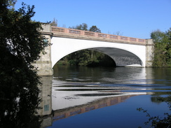
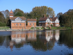
On the other side of the lock the path rejoined the riverside, and headed down to the M4 bridge. This massive bridge was actually surprisingly pleasing, with a complex arrangement of steel girders spanning the river from side to side. The girders and concrete decking reverberated from the pounding from the traffic overhead, giving a sort of drum effect underneath. The next stretch of path was fairly simple and easy going, with some occasional good views over the river. To my left, mostly out of view, was the recently-constructed Eton rowing lake, and soon on the other side of the river the superbly Gothic Oakley Court came into view.
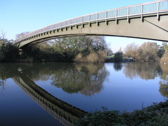
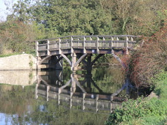
Although it was a pleasant walk there was not much to note until I passed the end of the rowing lake to the left, with a large wooden building standing at the end of the lake, presumably some form of control tower for the races. The path soon reached Boveney Lock, and a short distance further on came the spot where I had left the Thames Path on a previous walk from Marlow in 2000, heading off north into Slough. This time I walked on instead, crossing an elegant footbridge before following the river as it curved around to reach the A332 bridge, which was carried over the floodplain by a long aqueduct.
This marked the approach of Eton and Windsor, and after passing under a railway bridge I started to get some good views of Windsor Castle high up ahead, on the other side of the river. These views dominated the walk into Windsor, until the path headed into buildings to reach the pedestrianised bridge over the river. The riverside in Windsor was particularly attractive, and I enjoyed looking at the castle's Keep, standing proud and visible down the High Street from the bridge.
The Trail then followed the southern bank of the river, skirting between the railway line and the river to reach Romney Lock, with short tantalising glimpses of Eton College available to the left. The path curved around Home Park, passing under a railway bridge to reach Victoria Bridge, where the path was forced to climb up onto the bridge, the arches under the bridge being blocked by fences, apparently a security measure to ensure the Queen's safety in Windsor Park.
Once across the bridge, the path followed the river for a short distance, before heading inland slightly to join the B470 in Datchet, which may or may not have it's attractions; I was to busy keeping my head down to really notice. The walk through Windsor Park must be much preferable to this road trudge, and it is a shame that it has been closed off. It was a relief when the Trail headed off to the right away from the road after about half a mile, heading back down to the river and following it for a short distance until Victoria Bridge is reached.
This was crossed, so that the trail regained the southern bank of the river now that Windsor Park had ended. It was a pretty walk as the trail joined the New Cut in Old Windsor, built to cut a loop out of the river, and headed on towards Old Windsor Lock. Shortly beyond the cut ended, and the trail rejoined the river as it headed south. When the river met a road there was a pub, and I nipped in to this for a break, ordering a pint of bitter and a pint of orange juice to sup alongside a basket of cheesy chips. I knew that I could not spend too long eating as there was still a long way to go, but the break was welcome.
At the restart I found that my feet were starting to get sore, and this was annoying until I got into my stride after about half a mile, by which time the path had passed the two lodges designed by Sir Edwin Lutyens, and entered Runnymede Park. This was a place that I had heard much of in the past, almost all of which was in relation to King John signing the Magna Carta in 1215. I was not aware of the attractive open space that comprised the parkland, or of the memorials that lined the ridgeline in the distance.
It was a pleasant stroll that ended all too soon, as the path curved away from the road and headed round a large car park, with lots of fishermen lining the riverbank. The area around the river started to become more built up, and I was soon at Bellweir Lock and, soon afterwards, passing under the bridges that passed under the M25 and a couple of approach roads. On the other side of the bridge that path squeezed between the river and a large fence, but the view over the river, complete with a two-woman scull, were attractive.
I soon found myself reaching Staines Bridge, where the trail crossed over to the northern bank of the river. Staines seemed very neat and tidy, and although built up and modern is was surprisingly attractive around the riverside. This continued to be the case as the trail passed under a rail bridge, and started heading south along the river towards Laleham. After passing round a little loop in the river, the path reached Penton Hook Lock, where the Thames goes around a small island. By the lock there was a couple looking up into the trees beside the river, and when I heard a funny call I looked up, and was amazed to see parrots flying between the branches!
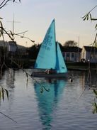
The path continued on into Laleham, where a couple of pumpkins beside the path showed me how near it was to Halloween, and the path continued southwards alongside the river towards the bridge under the M23. It was starting to get dark, but there were still many rowers on the river, mostly in canoes but also a couple of sculls travelling back and forth. It was a pleasant sight, and it took me on under the M3 and on to Chertsey Lock. Like Bray Lock this was meant to be shut from earlier on in the week for construction work, and although there was some equipment around a barge was still being let through.
A short distance further on was, for me, the architectural highlight of the day - Chertsey Bridge, a lovely stone bridge consisting of a series of arches, slightly humped in the middle. In the low sun the stone glinted magnificently, but unfortunately the same sun made it hard to find a good angle from which to take any photographs. The path then followed the river as it wound around some meadows, before passing some house boats, including one that had a line of wind chimes hanging from trees outside it, along with a sign almost imploring passers-by to play with them. I did so as I walked, and the chimes rang in my ears as I walked along in the lower light towards Dockett.
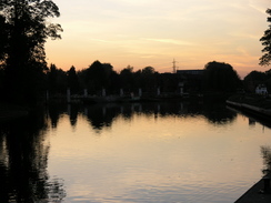
Heading on, the path passed an inviting pub, but it was getting darker and so I pressed on to reach Shepperton Lock, by which time the surrounding sky was beautifully red. A few yards further on the Trail splits; a southern branch crosses the river via a ferry, but I was using the alternative route that headed away from the river along a wooded lane. I was surprised to see that the ferry was still running even though it was getting dark, but it was there, with a couple of cyclists disembarking.
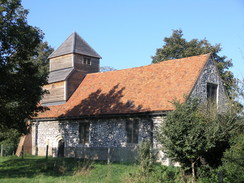
As the Trail entered Shepperton, it passed an attractive but small church beside the road, and then approached a little park. Here I left the Trail, and I continued on north through the town, passing the war memorial before heading north along a street that was still busy despite the fact that by now it was dark. I soon reached the station, and had about fifteen minutes to wait for my train back into the centre of London. This took an hour, and by the time that I got back to my car and then drove back to Cambridge. It had been a really long but rewarding day, along what is turning out to be a surprisingly nice National Trail.
 |
 |
|
 |
 |
|
Directions
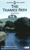
| The walk is also covered in detail in the Thames Path National Trail Guide, by David Sharp, ISBN 1-84513-062-6 published by Aurum Press Ltd. Click on the image to the right to go to the Amazon page for the book.
|  |
Distances
| From | To | Distance (m) | Ascent (ft) | Descent (ft) |
|---|---|---|---|---|
| Maidenhead station | Windsor | 8.0 | 141 | 167 |
| Windsor | Staines | 8.0 | 118 | 141 |
| Staines | Shepperton station | 7.2 | 128 | 135 |
This makes a total distance of 2.2 miles, with 387 feet of ascent and 443 feet of descent.
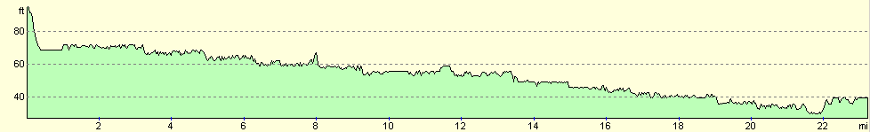
For more information on profiles, ascents and descents, see this page
Transport
Today's travel was split into two halves; I initially caugt a train from Paddington to Maidenhead in the morning (which cost me about eight pounds and took twenty minutes), and at the end of the walk caught a train from Shepperton to Waterloo (at a cost of Ł5.90; the journey took an hour).
Disclaimer
Please note that I take no responsibility for anything that may happen when following these directions. If you intend to follow this route, then please use the relevant maps and check the route out before you go out. As always when walking, use common sense and you should be fine.
If you find any information on any of these routes that is inaccurate, or you wish to add anything, then please email me.
All images on this site are © of the author. Any reproduction, retransmissions, or republication of all or part of any document found on this site is expressly prohibited, unless the author has explicitly granted its prior written consent to so reproduce, retransmit, or republish the material. All other rights reserved.
Although this site includes links providing convenient direct access to other Internet sites, I do not endorse, approve, certify or make warranties or representations as to the accuracy of the information on these sites.
And finally, enjoy your walking!
Nearby walks
| # | Title | Walk length (miles) |
|---|---|---|
| 60 | Slough to Alperton | 16.7 |
| 61 | Reading to Marlow | 18.5 |
| 62 | Marlow to Slough | 16.3 |
|
|

|