Walk #869: Winchester to Pitton
 |
 |
|
General Data
| Date Walked | 18/10/2010 |
| County | Hampshire, Wiltshire |
| Start Location | Winchester car park |
| End Location | Pitton |
| Start time | 07.50 |
| End time | 17.27 |
| Distance | 24.2 miles |
| Description | This was a long walk, for the most part following the Clarendon Way westwards from Winchester cathedral. |
| Pack | Today I carried my Macpac Glissade rucksack containing my North Face Westwind tent, camping gear, waterproofs, water, and foor for one day. |
| Condition | I am very tired after this walk. |
| Weather | High, hazy cloud dominated today's weather; the sun rarely shone through. It was a fairly warm day for the time of year. |
| OS map | Landranger number 185 (Winchester & Basingstoke, Andover & Romsey) and Landranger number 184 (Salisbury & The Plain, Amesbury) |
 |
 |
|
Map of the walk
Maps courtesy of Google Maps. Route for indicative purposes only, and may have been plotted after the walk. Please let me have comments on what you think of this new format. For a detailed table of timings for this walk, please see the table file.
 |
 |
|
Notes
It had been five frustrating weeks since I last managed to do a walk, and I really wanted to get out once again. The Clarendon Way - which runs between the cathedral cities of Winchester and Salisbury - has been on my list to walk for some time, but I had yet to get around to it. The official documentation states it as being 24 miles long, but measuring on the map shows it to be nearer 27, and longer if you walk between the railway stations. It felt like a good walk to attempt to get back into the walking habit, and I decided to walk it whilst carrying full camping kit, just for the extra strain. It was therefore unlikely that I would be able to complete the whole thing in one go, especially as I had not been walking for some time. I had also been ill the previous evening, which had almost made me cancel this outing.
One of the largest problems that faced me was the length of the day at this time of year - the walk would take me about ten hours, and there is scarcely enough daylight to allow this in the middle of October. For this reason we set off early, with Sencan in the passenger seat. Ideally I wanted to start the walk as near to the cathedral in Winchester as possible, but in the end we parked temporarily in a long-stay car park to the north of the city. My large rucksack was already packed, so I shrugged it on, kissed Sencan goodbye and set off.
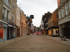
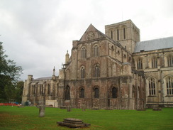
I had never been in Winchester in the early morning before, and I was surprised by how quiet it was. The streets were virtually empty, and even the High Street - usually bustling during the daytime - was virtually deserted, allowing me to take some photos of it without anyone else in. I had already covered nearly a mile before I reached the start of the Clarendon Way at the main entrance into the cathedral. Without further delay, I set off. The route took me past the southern side of the cathedral, and then past a series of private schools and colleges. Parents were walking their immaculately-dressed children to school, and I got more than a few strange looks.
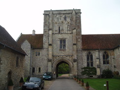
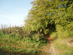
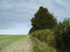
After passing the ruins of Wolvesley Castle, the path started following a stream southwards. It was a pleasant walk, especially when the top of St Catherine's Hill became visible to the southeast. I was feeling absolutely fine, and my pack was not proving troublesome at all despite the weight. Despite having spent many happy days in Winchester, I had never actually walked this particular route before, and it felt good to be on new territory. Soon the church of the St Cross Hospital became visible, and I passed this to reach a road. The first climb of the day took me up a footbridge over a railway line, after which a green lane took me up towards Oliver's Battery (one of many such named places in the area; named after Oliver Cromwell and the civil war). It was a surprisingly pleasant stroll, and the high hedges on either side blocked views over the city; the only sign of it was the intrusive noise of the traffic.
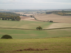
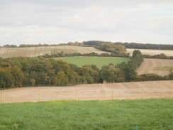
I stopped to buy a couple of chocolate bars in a shop at Oliver's Battery before heading on out of the city. The Clarendon Way takes a very looping route to the south of Winchester, adding a couple of miles over the rather more direct route. I can see little reason for it to do this, especially as there is probably as much road walking as the direct route. Roads took me past Teg Down, and the first expansive views were available to the east over the Royal Winchester Golf Cub course. There was a small apple lying on the road, so I spent a few minutes kicking it up the hill and down the other side. It eventually disintegrated halfway up the second slope, just before some large transmission masts were reached.
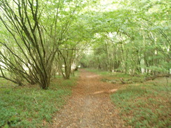
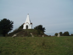
The Roman Road between Winchester and Salisbury was reached next, and this took me westwards towards Farley Mount Country Park. A path started on the right shortly after a car park, and this made a pleasant, traffic-free diversion. The toes on my right foot were starting to ache, causing me to limp slightly, I had bound these the previous night to prevent blisters, and it appeared that it was having the opposite effect. Not many people were about in the country park, but the route was easy to find nonetheless. Eventually the park was left behind, and the path led towards the monument on Farley Mount. Unfortunately the Clarendon Way does not visit it, so I diverted off the path and climbed up to the oddly-shaped monument. A bench gave good views over the terrain I had just walked, so I sat down and took my right boot off, removing the plasters and giving my foot a little massage. My two smallest toes both had formative blisters, and I could only hope that they would not become worse.
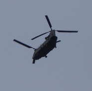
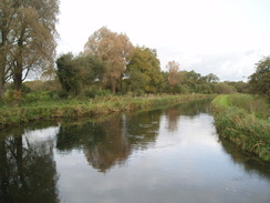
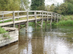
A familiar sound swept across the landscape as I restarted, and I managed to get a good photograph of a Chinook helicopter as it came directly overhead. What followed was a surprisingly hilly walk to Kings Somborne; none of the ascents or descents were particularly steep, but I started to feel the weight of my pack. My right foot, fortunately, was fine. Before I had set off, I considered Kings Somborne as being a reasonable place to stop the walk early, as it has some handy bus links. Fortunately I was feeling fine, so I ignored the shop and pub, and instead strolled on. A steep hill took me out of the village, and this was then followed by a steady descent down to cross the old Southampton to Newbury railway line, which now carries the route of the Test Way. After this two bridges took me across parts of the River Test, which in this area is formed of many different streams. The second of these bridges was a long, wooden footbridge, the track crossing by means of a ford. I doubt the ford is used very often, however, as the river looked deep enough as it was.
I sat down on a bench by the road in Houghton in order to readjust my right sock - a consequence of having put it on damp earlier - and headed off. The next stretch of walk to Broughton was very up-and-down, but none of the hills were too strenuous. Soon I saw two lads walking towards me and we stopped for a quick chat. They were also walking the Clarendon Way, and they had covered thirteen miles from Salisbury. As I had already done fifteen, I was just about over halfway through my walk. Their words started to give me a few doubts about my completion, however - I was starting to get fairly tired, and my feet were starting to ache.
The pub in Broughton seemed like a good place to remedy this. Although I was pressed for time, it seemed like a good idea to stop off and have a drink. I also got the barmaid to fill up my water bottle - I had been running out, and was annoyed when I got the Platypus out of the front of my pack and found that it was still half-full of water. The flexible bottle had been squeezed shut, a problem that sometimes occurs. The short rest did me a great deal of good, and soon I shouldered my rucksack once again and headed off.
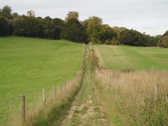
The ascent westwards out of Broughton was very steep and had me gasping for breath. Once at the top I joined a track that slowly rose and fell, nothing too severe, but all trying for tired legs. The Roman Road was rejoined at Buckholt Farm, and this took me westwards. This stretch of path is also in conjunction with the Monarch's Way, a winding long-distance path that I would like to do sometime.
It was a relief when the first buildings of Middle Winterslow came into view. The path through the village seemed easy enough on the map - just head straight along the northern edge. Unfortunately it did not prove to be so easy in practice, and I found myself following a green track past some woodland. Only then did the fatigue hit me and I was sick behind some bushes. I wiped my mouth, swilled my mouth out with some water and instantly felt better. Something felt wrong, however, and a quick glance at my GPS showed that I was well off route. Somehow I had taken a wrong turn in the village. Despondent, I turned around and headed back to find the proper route. All in all this had cost me about three-quarters of a mile, and I realised that it would be a very tall order to reach Salisbury before it got dark. I reevaluated my options, phoned Sencan and we agreed to meet up at the pub in the village of Pitton, a couple of miles further on.
As I still wanted to return to do this westernmost portion of the Clarendon Way, I decided to do a slightly alternative route. Instead of following the Clarendon Way between the two villages, I continued westwards along the old Roman Road. Fortunately this proved to be easy going on tired feet, and I soon reached the oddly-named road junction at Dunstable Corner (which, naturally enough, is nowhere near Dunstable). From here a mile and a half of road walking took me southwestwards into Pitton. I eventually found the Silver Plough pub, but unfortunately it was not due to open for another half hour, at six. I shrugged my rucksack off and started reading a book as I waited. A whole crowd of people turned up and they also waited.
Sencan arrived at about half six, and I finished my pint before clambering into the car. Although I had failed in my main aim of walking the Clarendon Way I was satisfied - I had walked well over twenty-four miles with full camping gear, over terrain that was far from flat. This, coupled with the fact that I had not walked for five weeks, means that I am still walk fit.
 |
 |
|
Directions
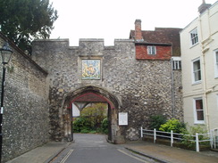
This walk starts off from the main entrance at the western end of Winchester Cathedral, and follows the Clarendon Way for nearly the entire day. Head south past the entrance, and then immediately left along a path for a few yards that skirts the southern side of the nave. Turn right down a surfaced road that heads south with a grassy area on the left; the road curves to the left and then the right to join a road called Dome Alley. Turn left along this and follow it as it curves around Cathedral Close. It heads under an archway to join St Swithun Street. After a few yards turn left to head south down Kingsgate Street, then left once more to start heading east-southeastwards down College Street.
When the entrance to the ruins of Wolvesey Castle is reached on the left, turn right down College Walk. When this curves sharply to the left, turn right down a short dead-end road. When this ends, turn left past a metal gate to join a footpath that heads south-southwestwards with a stream on the right. After 0.4 miles Garnier Road is reached; cross the road, turn right and then left to join another footpath that heads south-southwestwards with the stream now on the left. When the wall of St Cross Hospital becomes visible ahead, angle towards it and turn right to head westwards, with the wall on the left. The path becomes a track, Back Street, which ends at St Cross Road beside the Bell Inn.
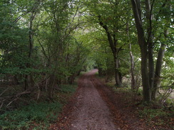
Carefully cross the road and turn right to head north for about twenty yards, then turn left to head westwards up Mead Road. When this curves to the right turn left to access a footbridge over a railway line. Cross this to access a path on the other side. Turn right along this good path, and then immediately turn left to join a track called Whiteshute Lane that runs between hedges. Follow this track southwestwards as it climbs uphill for two-thirds of a mile. Near the top it approaches the A3090 road; before it descends down to cross the road, turn right for a few yards and then left to reach a footbridge over the road.
Cross the footbridge and take the second path on the right, which heads southwestwards between hedges for a fifth of a mile, passing a school on the right. The path reaches a track, and a few yars further on meets a road called Oliver's Battery Gardens, with a caravan park on the left. Turn right down this road, and hen it ends turn right to join Compton Way. Follow this northwards; after a few hundred yards it curves to the right to take a north-northeasterly direction, At SU459276 Compton Way curves to the left to end at a T-junction with Oliver's Battery Road South. Turn right and follow this road northwards for a few hundred yards until it reaches the A3090 road.
Turn right to a subway, and use this to access the northern side of the road. On the other side, head north for a third of a mile along Oliver's Battery Road North; this curves to take a more north-northeasterly direction before it ends at Stanmore Lane. Turn left along Stanmore Lane for about fifty yards to a junction with the B3040 Romsey Road. Carefully cross this and continue northwestwards along Kilham Lane. This heads northwestwards and then northwards for half a mile until it meets Sarum Road at SU454290.
Cross this road and continue on northwards along a lane, with the Royal Winchester Golf Club on the right. This lane rises and falls, passing some transmitter masts on the left before slowly curving to the left. It heads in a rough westerly direction, becoming Lanham Lane as it curves to head southwestwards, with Crab Wood Nature Reserve on the right, before ending at Sarum Road once more at SU438291. Turn right and start following Sarum Road westwards; it descends to a crossroads. On the other side the road starts to climb; after about a hundred yards a car park is reached on the right. Enter the access road to this and then immediately turn left to join a path that heads westwards parallel to the road.
At SU423293 the road curves to the left, and the path continues on westwards, descending down to leave the trees and reach a cleared area. Continue westwards with the trees on the right, following a rough track. When some more trees are reached turn left to start heading uphill to the south with the trees on the right. This reaches a car park immediately to the north of the road. turn right onto gravel path that heads through a small patch of trees; head through a clapper gate, then half-right past a barrier onto a gravel path. This curves around to the right and then the left across an area of open ground. It finally settles in a southwesterly direction, passes a car park and meeting a road at SU408293. Cross this road and start following a track that heads southwestwards on the other side. This track slowly curves to the right before meeting the entrance to the monument on Farley Mount on the left.
Continue on the track as it heads westwards along the crest of Beacon Hill. At SU397290, shortly after the track curves to the left, turn right down another, narrow track that heads steeply downhill in a northwesterly direction, initially with woodland on the left. The trees soon end, and it crosses a field to end at a bend in a road at SU390296. At the bend turn left to follow another track southwestwards; after a couple of hundred yards this turns sharply to the right to head northwestwards. It soon enters some woodland and climbs up once more.
Near the top of the hill it curves to the left to rejoin the course of the Roman Road. At SU377298 the path curves to the right to take head in a northwesterly direction, for a long period with old horse gallops immediately on the left. Once the gallops curves away, the path continues on uphill before descending on the other side to end at Winchester Road on the eastern outskirts of King's Somborne. Turn left and start following this road as it curves around to the right in a more westerly direction. Shortly after this bend turn right and then left, crossing a stream to join Old Vicarage Lane. When this road forks, take the right-hand fork that soon ends at the A3057 road.
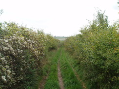
Carefully cross this road and turn right for a few yards, before turning left to head north up Cow Drove Hill. After the last house on the left, a footpath heads off to the left onto the other side of the hedge. Turn right to head north with the hedge and road on the right. At the top of the hill the footpath meets a track; here turn left and start following this track westwards. When the main track curves to the right continue on along another track. This heads westwards, descending steeply to cross the Test Way at SU350315.
Cross the Test Way and continue on another track westwards. This soon reaches a bridge over a stream of the River Test and continues on southwestwards on the other side, soon curving to the right to head northwestwards. At Blacklake Farm the track curves onto a westerly course to reach a ford over another stream of the River Test. Cross the footbridge beside the ford and follow a track west; this soon ends at a road in Houghton.
Turn left to head southwestwards along the road for a hundred yards, and then take the first road to the right, Faithfulls Drove. Initially this is surfaced as it climbs, before becoming an unsurfaced track. It is easy to follow as it curves in a westerly and west-northwesterly direction for 1.5 miles; it becomes indistinct for a period near a clump of trees. It reaches a track at SU317325; turn right along this track for a couple of yards before turning to the left to join a footpath that heads west-northwestwards with the back gardens of houses on the left. At SU312327 turn to the left and immediately right to join a track that heads north-northwestwards; after a quarter of a mile at SU311331 turn left to join a track. This squeezes beside a wall before joining Rectory Lane; this climbs uphill to meet the High Street in Broughton.
In Broughton, turn left and then immediately right to start heading southwestwards up Queenswood Road. When this road forks, take the right-hand fork to join the B3084 road. Head northwestwards along this road for a few yards, before turning left to join Buckholt Road. Follow this uphill to the southwest; when a complex junction is reached at SU300325 take the second path to the right. This starts to climb steeply uphill in a west-northwesterly direction; it enters some trees and then curves to the left before reaching the top of the hill.
At SU296325 take a track that leads off to the right, heading slightly south of westwards and soon passing a covered reservoir on the left. It crosses another track at SU287322 and winds around, falling and climbing once more to approach Buckholt Farm. Just before the farm is reached, turn left along another track, and then after about fifty yards turn right to pass a barn and reach a bend in a road at SU276321. Follow this road in a slightly north of westerly direction; when it ends after 0.6 miles at a T-junction, continue straight on along a track. After a mile this track becomes a road, which in turn soon ends at a road on the eastern outskirts of Middle Winterslow. Turn left down this road for a few yards and then turn right along Gunville Hill road.
After a short distance this road curves to the left; continue straight on along The Flashlett. When this ends, continue straight on along a footpath that heads westwards across a field, passing near to an electricity pole on the way. The path skirts a hedge on the left until the field ends, and then turn left and immediately right to join a track. Follow this track west-northwestwards; it becomes a road called The Causeway that ends at a junction with Middleton Road.
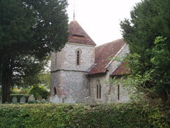
Continue along Middleton Road until it curves to the right at SU236331; here continue straight on along a track that heads westwards. Here I left the Clarendon Way by continuing along the track as it descended down the hillside, rejoining the course of the Roman Road at the bottom. Follow this track westwards for a third of a mile until it ends at a road. Turn right along this road and follow it northwestwards for a hundred yards until a crossroads is reached at Dunstable Corner (SU223332). Here turn left and join a road that heads southwestwards for 1.25 miles. It enters Pitton, passing the church and then the post office on the right. When a crossroads is reached, turn left along White Hill. This heads southeastwards; this walk ends after about two hundred yards at the Silver Plough pub on the left.
 |
 |
|
Distances
| From | To | Distance (m) | Ascent (ft) | Descent (ft) |
|---|---|---|---|---|
| Winchester long-stay car park | Farley Mount | 8.7 | 879 | 476 |
| Farley Mount | Broughton | 7.6 | 525 | 942 |
| Broughton | Pitton | 7.9 | 850 | 709 |
This makes a total distance of 24.2 miles, with 2254 feet of ascent and 2127 feet of descent.
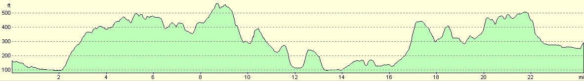
For more information on profiles, ascents and descents, see this page
 |
 |
|
 |
 |
|
 |
 |
|
 |
 |
|
 |
 |
|
 |
 |
|
Disclaimer
Please note that I take no responsibility for anything that may happen when following these directions. If you intend to follow this route, then please use the relevant maps and check the route out before you go out. As always when walking, use common sense and you should be fine.
If you find any information on any of these routes that is inaccurate, or you wish to add anything, then please email me.
All images on this site are © of the author. Any reproduction, retransmissions, or republication of all or part of any document found on this site is expressly prohibited, unless the author has explicitly granted its prior written consent to so reproduce, retransmit, or republish the material. All other rights reserved.
Although this site includes links providing convenient direct access to other Internet sites, I do not endorse, approve, certify or make warranties or representations as to the accuracy of the information on these sites.
And finally, enjoy your walking!
Nearby walks
| # | Title | Walk length (miles) |
|---|---|---|
| 709 | South Downs Way: Winchester to Wether Down | 20.4 |
| 787 | Romsey to Eastleigh via Winchester | 21.1 |
| 788 | Romsey to Salisbury | 23.1 |
|
|

|