Walk #610: Rugby to Nuneaton
 |
 |
|
General Data
| Date Walked | 19/06/2004 |
| County | Warwickshire, West Midlands |
| Start Location | Rugby |
| End Location | Nuneaton |
| Start time | 09.03 |
| End time | 16.08 |
| Distance | 19.5 miles |
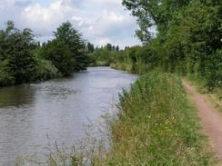
| Description | This was a long walk following the towpath of the Oxford Canal. |
| Pack | Today I carried my 30-litre Karrimor HotRock rucksack, which was filled with my waterproof leggings, water bottle, trainers and a couple of spare shirts, together with the usual assortment of odds and ends. It weighed slightly more than usual as I also carried a couple of litres of extra water. |
| Condition | I was quite tired after this walk, but was fine for the drive back to Cambridge. I have a hot-spot on my left heel, and some blisters on my little toes, but aside from this I am fine. |
| Weather | The weather today was very mixed, with sunshine, dark clouds and heavy downpours all mixed together. Fortunately the showers were infrequent and there was only one very heavy one. |
| OS map | Landranger number 140 (Leicester, Coventry & Rugby) |
 |
 |
|
 |
Map of the walk
Maps courtesy of Google Maps. Route for indicative purposes only, and may have been plotted after the walk. Please let me have comments on what you think of this new format. For a detailed table of timings for this walk, please see the table file.
Notes
Doing this walk came as a slight surprise to me, as until last night I had been intending to do a walk nearer home, from Market Harborough to Corby, as part of a two-day route up to Oakham. Unfortunately I left the relevant Ordnance Survey map at work, which rather kyboshed my plans. Instead of going back to work late at night to fetch the map, I decided instead to do a different walk, and a canal side walk appealed to me as I had not done one for some months. In the end I settled for a walk from Rugby to Nuneaton, which would hopefully allow me good transport links back and also be a fairly nice stroll. The distance also looked fine, at about twenty miles.
The day started off badly as the drive to Rugby took me half an hour long than I had been expecting, due to the A14(T) being closed between two junctions for road works. The diversion took me up nearly as far as Corby, a long way off route, along roads that were not exactly slow, but not quite speedy either. And when I finally reached Rugby, I could not find the road that led to the station; a doubly annoying mistake as it seemed exceptionally easy on the map. After driving around for ten minutes I finally found myself at the station, and not wanting to pay the five pounds parking fee (even payable on Saturdays), I drove to a side street about five minutes walk away. One thing that I did not know as I drove along the A14 towards the M1, was that the sight of eight of the radio transmission masts at Rugby - which for me mark the junction of the A14 and M1 from miles away - are to be demolished tonight, leaving only four remaining. This is a shame as they form such a prominent mark on the skyline, and it will not seem the same reaching that junction without them being present.
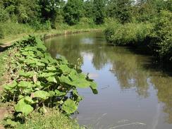
It did not take me long to put my boots and rucksack on, and I soon found myself at the railway station. After walking for a couple of minutes I tried to put my Walkman on, only to discover that stupidly I had packed my Walkman but not my headphones! A quiet, contemplative walk was obviously going to be called for. The first stretch of the walk northwards was nothing to right home about as it passed through a mainly built-up area, although it did cross the River Avon and pass a convenient shop, where I managed to by some food for the day's walk. When I reached the canal, however, this all changed; I have often thought of canals in urban areas to act as a form of green oasis, and this was precisely the case here. On leaving the road and joining the towpath I felt like I was in a different world, and although it was still an urban area only the chain-link fence to my left, heavily overgrown with weeds and creepers, betrayed the fact.
I had walked the southernmost sixteen miles of the Oxford Canal late last year, and so it was nice to be walking the northernmost stretch (although I have a fifty-mile gap to fill in between the two sections!). The walk was quite pleasant, and I enjoyed having the waters beside me as I walked; time seemed to fly by, and before I knew it I was passing under the M6 and then the M69 bridges. Between the two it started to rain heavily; there had been a short shower before, but that had only lasted a couple of minutes and I had not get very wet. This time it looked different with dark, foreboding grey clouds all around, and so I put my rucksack onto a container for stoppage boards made out of brick and stone slabs, and out my coat on. The rain began to fall with increasing severity, and although the shower only lasted for about twenty minutes my trousers were well sodden by the time that it stopped.
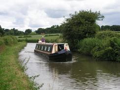
To add insult to injury, as soon as I began to dry off the towpath passed through an area of waist-high grass, and my trousers once again became soaked from the moisture that was on the grass. For the previous two or three miles I had slowly overhauled a canal boat until I was a short distance ahead of it, but the long grass had slowed me down and so I was level with it once again. As I walked I started chatting to the couple on board the boat, and we had an enjoyable chat as we headed along the canal by very different forms of transport. I eventually left them behind when they moored for lunch at the entrance to a little marina.
I was feeling quite tired by now, and so I passed a pub by the B4109 road before finally settling on having lunch at the Greyhound Pub, at the junction of the Oxford and Coventry Canals. I went in and was immediately subsumed into a jovial atmosphere; I ordered a pint of Dark Mild (not quite as nice as I would have liked, but a treasonable tipple) and sat down at a table. The pub has a large framed photo of Winston Churchill hanging on the wall, and there were D-Day souvenirs everywhere; it was obvious that the 60th anniversary of the event had not passed them by. The atmosphere in the pub was quite nice, and this allowed me to relax and dry out even more.
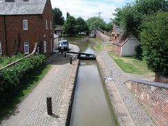
It was exceedingly tempting to stay for another pint or two, but I was aware that time was pressing and so I shouldered my rucksack and set off once more. The area around the canal junction - known as Hawkesbury Junction, is quite nice, with a large pumping house with tall chimney, a lock with a low drop (the only lock I passed on the entire day), and some attractive bridges, including a beautiful cast-iron bridge over the actual junction. I took some photographs of the scene, and then crossed the bridge and set off northwards along the Coventry Canal. As I walked I continued to take photographs; after taking one of them I put my camera back into the case, which was attached to the hip-belt of my rucksack, and moved my hand away. Unfortunately the Velcro on the end of the sleeve of my coat had caught on the camera strap, and as I moved my hand away the camera flew up in the air and dropped down, not onto the grass on either side, but onto the stony path.
With my heart in my mouth I picked up the camera. The lens cap had fallen off in the impact, and the top of the mode selector dial was scuffed, but the lens appeared to be intact. I tried switching the camera on, and to my dismay the motor controlling the lens juddered but would not emerge from the body. I tried several times as I walked along, and always with the same result. The batteries in the camera were low on power, so I put some fresh cells in, but this also had no effect. This was all very upsetting, and put me in quite a bad mood as I walked along. This was not improved when I reached Marston Junction, the junction between the Coventry and Ashby-de-la-Zouch canals, and found a large spiked metal gate blocking the way.
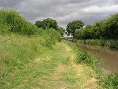
There were a couple of men on the other side of the fence, and they had walked down from Nuneaton to find the way blocked by this fence. The towpath was closed for works, and although I considered joining roads for the last couple of mils, they told me that they path was perfectly walkable and that there were no workmen about. The problem was how to get around the fence; it was covered with anti-climb grease at strategic points, and the fence continued into the canal on a very shaky section of fencing that I was sure would not take my weight. I had a quick scout around, and then worked out by going through a little area of scrubland and jumping down off a wall I could get round. The two men tried this from their side of the fence, and we met halfway in the undergrowth of brambles and nettles. I soon found myself on the towpath, which was obviously being rebuilt as a cycle path. The going was very easy, and I walked easily along it for a couple of miles towards Nuneaton, where a second fence marking the northern boundary of the works proved exceptionally easy to get around.
As I approached the southern outskirts of Nuneaton I was surprised to hear loud music, and I started wondering how the neighbours could cope with such loud music being played. As I joined the road I was surprised to see traffic queuing for a long way, and as I walked on all became clear in the distance; Nuneaton carnival was in full flow. I watched the carnival floats pass by as I walked along the road, and I found myself wishing that my camera was working so that I could take some photographs of this unusual sight - I had never passed a carnival on a walk before. The sight of everyone enjoying themselves put me into a good mood, and when I reached the centre of the town I decided to go into a camera shop. I knew that if I sent my old faithful C5050Z in for repair it would be away for some time, so I decide to get myself a weatherproof Olympus mju410 camera, the same sort I had recommended a friend get a couple of weeks before. Although this is a slight retrograde step (it is 4 Megapixel as opposed to 5, and has an inferior lens), it is smaller and weather proof, therefore more suitable for walking. I have been considering upgrading my camera to an 8 Megapixel Olympus C8080Z, but that camera is not ideal for walking (it does not run off AA's and is larger than the C5050Z), so I decided going for a smaller camera was a far cheaper and better option.
I walked past the bus station to check the bus timetables back to Rugby. Unfortunately the booth marked 'information' was totally devoid of any information, and so I decided to walk to the station as I knew that a train (via Coventry) was due in fifteen minutes. Once I got to the station, which was only a couple of minutes walk form the bus station, I was faced with a small queue for the ticket office. Unfortunately the people in front of me were all asking long and complex questions, and the minutes slowly ticked by as I was waiting. To make matters worse a lady behind me lit up a cigarette and soon the noxious fumes were drifting in front of my face. I got to the ticket window with a couple of minutes to spare, and after purchasing the ticket I was told that, due to the West Coast Main Line upgrade program, trains to Coventry were not running and I would have to take a bus instead.
The bus ride to Coventry was uncomfortable as I was sitting at the back, and every time the bus went over one of the numerous speed bumps my head would hit the roof. I ended up slumping down in the seat. When I arrived at Coventry Station I unfolded myself and went into the foyer. Annoyingly, according to the timetable in the station I had missed a train to Rugby by one minute due to the fact that the bus service was slower than the train. This really annoyed me, but when I asked a member of staff they told me that the trains were not running and that a bus to Rugby was due to leave in 25 minutes from the front of the station. I went outside and waited for ten minutes, before asking a bus marshal whether the bus to Rugby was in yet. He said that no busses were running, and that I would have to get a train instead! I went inside and asked at the ticket office (which I surely should have done in the first place), and found that a train was due to leave in just a couple of minutes. I ran to the relevant platform, and although the train was ten minutes late in arriving, I still got back to Rugby far earlier than would have been the case if it had been a bus service. So ended a long and dismaying day, which, although it was a pleasant stroll, was spoilt by so many things that were inside and outside of my control.
For more details of the Northern section of the Oxford Canal, see Jim Shead's excellent website. Likewise, he also has details of the Coventry Canal.
This walk starts off at Rugby railway station. Leave the station, and then turn left along Railway Terrace for a few yards to reach a T-junction with Mill Road. Turn left, and immediately the road heads under the railway line on a narrow and long bridge. Once out from under the bridge continue straight on as the road heads in a rough northerly direction, until it ends at a T-junction with Boughton Road. Turn left, and follow Boughton Road until it reaches the Oxford Canal by Bridge 59. Do not cross the bridge, but turn left to descend down to the canal towpath that runs along the southern bank of the river.
The rest of the walk is very simple; simply follow the southern bank of the Oxford Canal as it heads in a rough northwesterly direction for around thirteen miles; the towpath is waymarked as the Oxford Canal Walk, and remains on the southern side of the canal until the junction with the Coventry Canal is reached at Hawkesbury Junction. Here pass the lock and then turn right to cross bridge over to the eastern bank of the Coventry Canal. Follow the canal towpath that runs along the eastern bank of the canal, immediately passing a prominent old pumping station, and continue on northwards for nearly three miles until Marston Junction, with the Ashby-de-la-Zouch canal, is reached.
At Marston Junction cross the bridge over the mouth of the canal, and continue on northwards along the eastern towpath of the Coventry Canal for another couple of miles until the canal passed under a railway line. Immediately beyond this bridge is another one that carries the A444 over the canal. Here leave the canal, and join the dual carriageway above. Turn to the right, and follow the road down a slight hill towards a large roundabout. Here continue straight on, following the A444 Colton Road northwards for just under a kilometre until it ends at another roundabout. At this roundabout continue straight on, heading northwards through the centre of the town, aiming for the bus station, which is well signposted. Once at the bus station follow the signs for the nearby railway station, which is where this walk ends.
This makes a total distance of 19.5 miles, with 729 feet of ascent and 767 feet of descent.
There are regular train services between Nuneaton and Rugby, with some direct services and some more frequent ones running via Coventry. A single ticket cost me two pounds; I hope that your journey is considerably better than mine was.
Please note that I take no responsibility for anything that may happen when following these directions. If you intend to follow this route, then please use the relevant maps and check the route out before you go out. As always when walking, use common sense and you should be fine.
If you find any information on any of these routes that is inaccurate, or you wish to add anything, then please email me.
All images on this site are © of the author. Any reproduction, retransmissions, or republication of all or part of any document found on this site is expressly prohibited, unless the author has explicitly granted its prior written consent to so reproduce, retransmit, or republish the material. All other rights reserved.
Although this site includes links providing convenient direct access to other Internet sites, I do not endorse, approve, certify or make warranties or representations as to the accuracy of the information on these sites.
And finally, enjoy your walking!
Directions
Distances
From To Distance (m) Ascent (ft) Descent (ft) Rugby Station Bridge under the M6 8.3 420 413 Bridge under the M6 Hawkesbury Junction 5.3 184 200 Hawkesbury Junction Nuneaton Station 5.9 125 154 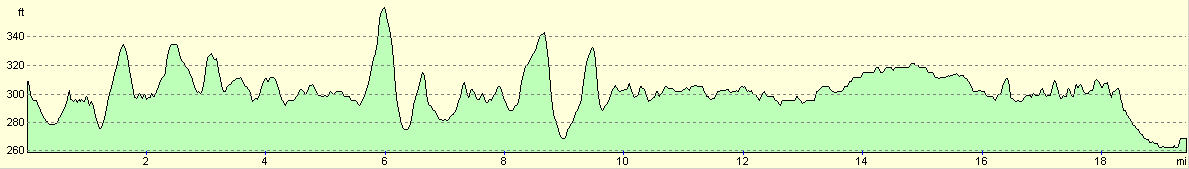
For more information on profiles, ascents and descents, see this page
Transport
Disclaimer
Nearby walks
| # | Title | Walk length (miles) |
|---|---|---|
| 158 | Bugbrooke to Braunston | 15.1 |
| 636 | A circular walk between Braunston and Rugby | 19.0 |
| 637 | Nuneaton to Tamworth | 18.4 |
|
|

|