Walk #611: Waterbeach to Ely
 |
 |
|
General Data
| Date Walked | 20/06/2004 |
| County | Cambridgeshire |
| Start Location | Waterbeach Station |
| End Location | Ely Station |
| Start time | 08.55 |
| End time | 13.40 |
| Distance | 13.2 miles |
| Description | This was a slight reworking of an old classic walk of mine, following the River Cam and Great Ouse northwards towards the Ship of the Fens. |
| Pack | Today I carried my 30-litre Karrimor HotRock rucksack, which was filled with my waterproof leggings, water bottle, trainers and a couple of spare shirts, together with the usual assortment of odds and ends. It weighed slightly more than usual as I also carried a couple of litres of extra water. |
| Condition | My feet ache after this walk, but that is mainly due to the lingering effects of yesterday's stroll. All in all I could feel much worse. |
| Weather | The day started off cloudy with some prolonged sunny periods, and there was a light breeze that was noticeable on the exposed flood banking. As the day went on the clouds gathered, and as I was walking around Ely it started to spit with rain. Fortunately this did not become anything heavier until I got back to the car, so I can hardly complain. |
| OS map | Landranger number 154 (Cambridge & Newmarket, Saffron Walden) and Landranger number 143 (Ely & Wisbech, Downham Market) |
 |
 |
|
 |
 |
|
Map of the walk
Maps courtesy of Google Maps. Route for indicative purposes only, and may have been plotted after the walk. Please let me have comments on what you think of this new format. For a detailed table of timings for this walk, please see the table file.
Notes
For some time I had been thinking about re-walking the short stretch of my Land's End to John O'Groats walk, between Waterbeach and Ely. There were several reasons for this; it is not a bad little stroll, and, far more importantly, it is a walk that actually proved that I could walk. After the last operation on my left ankle in May 1998, I started doing little walks from my flat in Waterbeach, initially only walking from the fat to Bottisham Lock, a few hundred yards that would take me half an hour. Over the following months I slowly increased the distance, before completing the 11 or 12-mile stretch from Waterbeach to Ely in September 1998. This proved to me that I could actually walk (something that came as somewhat of a surprise to me, and I therefore set myself the objective of walking the Pennine Way within a year.
Thus started a hobby that has become something an obsession for me. I have walked from Waterbeach to Ely on numerous occasions, all as training walks and to get myself fitter, and many before I started logging my walks at the beginning of 1999. But for a long time I have been slightly dissatisfied that I have no photographs of the walk; I have not done this walk since mid-1999, before I took photos of my walks. This seemed a shame, and so I have always considered doing it again to get some decent photos. After yesterday's terrible walk, I felt today would be a good opportunity do a no-hassle short walk, and I chose this as fitting the bill. I was tempted to extend the walk by starting off six miles further south in Cambridge, but I decided that this would slightly spoil the main point of the walk, which was to relive the stretch from Waterbeach to Ely.
I arrived at Waterbeach station after a very short drive - usually driving to the start of a walk takes me up to a couple of hours, but this morning it took me just twenty minutes. I parked my car and bought a ticket (it costs one pound to park here at the weekend and more during the week; note, that if you want to park here during the working week then turn up early as the small car park fills up very early. Even this situation is better than it was a few years ago, when there was no car park at all and commuters clogged up the streets of the little village around the station with their cars. I geared up with all my kit, locked the car and set off on the short stroll to Clayhithe Bridge; this was interesting as what was flat fields when I moved to Waterbeach in 1998 was now a mini-forest; a woodland was planted here just before the millennium and the trees have now sprung up, despite the floods that covered the area and the saplings for a couple of weeks in 2001, and which I thought must have killed off all the trees.
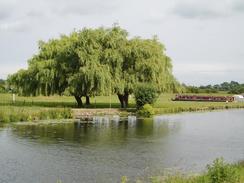
Clayhithe is quite a nice little site on the River Cam, with an adjacent pub, The Bridge, which has been refurbished in the last few years. As I went by at nine on this Sunday morning the car park was nearly empty and there was not a single person about; a marked contrast to how busy the pub gets on a sunny summer's Sunday afternoon. Right next to the pub is the bridge, and I soon descended down to the eastern riverbank and started walking northwards, following the Fen Rivers Way, which I would follow all the way to Ely. On the western bank of the river to the north of Clayhithe is a little marina, and this was just starting to wake up, with people fiddling abut with their boats before setting off for the day. No boats were actually moving, however, and I had the river to myself as I walked northwards to Bottisham Lock. This was my 'home' lock for a couple of years, and I used to enjoy watching weekend boaters tackling their first lock here; invariably many stood about scratching their heads as it is the first lock they would have tackled. Such things rather amuse me, although I daresay that I may not be much better if I had to do it.
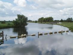
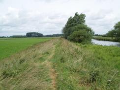
Bottisham Lock is many miles from the sea at King's Lynn, but is only the second lock on the river from the sea; the first, Denver Sluice, keeps the tide from spilling up the river. This always used to slightly concern me when I lived in a flat a couple of hundred yards away and below the level of the river; fortunately it never became a problem for me, however. At the lock I changed over from the eastern to the western bank of the river, and I would follow this all the way up to Ely. For most of the way the path runs on top of the flood bank, but in a couple of places the flood bank divert inland and the path runs along the floodplain beside the river. To my right, on the eastern side of the river, a series of channels, or Lodes, can be seen running into the river; these have had a long history, and some are even thought to originate in Roman times.
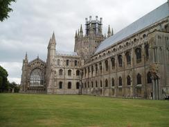
I soon reached the bridge that carries the A1123 over the River Cam at Dimmock's Cote. This bridge is a concrete structure that has been painted white, but with an overhead arch that is relatively attractive for a concrete structure. Shortly after this I got my first views of Ely Cathedral on the skyline to the north. The cathedral is known as the 'Ship of the Fens' and it was easy to see why; the grey roof merges with the sky above, leaving the towers sticking up into the sky like masts of a ship; it is a wonderful sight A couple of miles further on I reached the point where the River Cam meets the Great Ouse, and I would be following the latter river for the rest of the journey to Ely. The pleasant steel bridge over the Ouse here is a relatively new structure, having been built in the late nineties, and replaced a very ramshackle and dangerous bridge over the Ouse next to the railway bridge, a few hundred yards further upstream. Next to the bridge is a tiny pub, the Dog and Duck, which serve the adjacent marina and passing boats; to reach the pub by car involves a long drive along a track from the A1123.
The rest of the walk into Ely was quite straight forward with only a few points of note; as I headed northwards the river became more of a motorway with boats everywhere, and it was nice to see people enjoying themselves despite the rather changeable weather. A couple of miles north of the point where the Cam and Great Ouse meet the path follows a little inlet inland towards the nearby railway line; it then skirts the railway embankment for a few yards before heading out to the river once more. When I have walked along her before in previous years the channel has been more or less clear; this year, however, it was heavily clogged with weeds and plants, and indeed it was impossible to see the water, and with care you would have thought that you could even walk across it! The path then crossed the Ely to Bury St Edmunds railway line, before moving slightly inland from the river to reach the A142 road next to a bridge over the river, and near to the railway station.
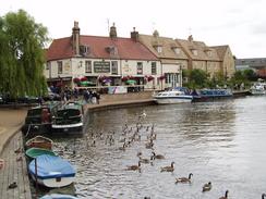
I still felt fit and had a little under an hour to wait for a train, so I decided that I would extend the walk slightly by going to look at the cathedral. It is a great shame to visit Ely without going to the cathedral, so I followed the river northwards towards the Maltings, and then headed uphill to the Cathedral. This is an absolutely fantastic structure, and although I did not have time to go inside for a look around, I walked around the Cathedral studying it in detail. It does not matter how many times I see this cathedral, I always find myself in awe at the scale and the craftsmanship that has gone into it. Mindful of he time I eventually pulled myself away from the studying the stonework, and descended through an area of parkland to a road, and eventually the station. After the hassles that I had with transport after yesterday's walk, I was relieved when the train was punctual, and I sat down and watched the scenery flash by as I travelled back to Waterbeach and the car.
For more details on this walk, please have a look at my page describing the Fen Rivers Way.
Directions
This walk starts off at Waterbeach railway station. Leave the station and at the road head eastwards along it (whether that is a left to right turn depends on which platform you started from). Walk past the entrance to the station, and then turn right down a footpath that heads for a few yards towards an area of new woodland. Before the woodland is reached turn left, and follow a footpath that skirts between the road and the woodland, heading eastwards for a short distance before turning to head southwards for a few hundred yards. This footpath ends at the western bank of the River Cam, immediately beside Clayhithe Bridge. Once at the Cam turn left and climb up to the road, and then cross the bridge to gain access to the eastern bank of the river. The rest of the walk as far as Ely followed the Fen Rivers Way, and is waymarked as such; navigation is simple; keep the river to your right. Once across the bridge turn left, and started walking northwards along the eastern bank of the river.
After a mile Bottisham Lock is reached. Once the lock is reached turn left and go through a little gate to access the footbridge over the lock, climb over this, and then cross the sluice to gain access to the western bank of the river; do not descend the slope down the bank, but turn right and start following the flood bank northwards. The rest of the walk is fairly easy; just continue following the Fen Rivers Way as it heads northwards; for most of the time this follows the top of the flood banking, but in a couple of places it drops down onto the floodplain and follows the riverbank for short distances. These places are well marked, and continuing onwards along the flood bank would be hard through many years' worth of vegetation. The only problem comes at the point where the Cam and Great Ouse rivers meet; here a nice arched footbridge arches over the Ouse, and allows you to cross the river safely. A couple of miles further north there is a little inlet that needs crossing; simply follow it inland to the railway line and a path crosses the inlet using the side of the railway embankment.
A kilometre further on the Ely to Bury St Edmunds railway line is crossed, and then it is a short walk to the A142 road in Ely. Ely Station is now a hundred yards to the left, but if you want to explore Ely a little more cross the road and continue on northwards along the river. The path dives under a railway bridge and past a couple of marinas before reaching the Maltings, which is now a prettified commercial area, with some lovely views along the river. Walk past the Maltings for a short distance before turning to the left to head northwards along Waterside; this soon joins Fore Hill, which can be followed uphill to the market place. Continue straight on, with the war memorial built into the wall on the left, until a gateway is reached on the left. Go through this gateway to gain access to the cathedral. Once through the gate turn right, and walk along the side of the cathedral to reach the main entrance at the western end.
Explore the cathedral and the surrounding area if you want, and then turn left to walk southwards along The Gallery, passing the Bishop's House and King's School, until a gateway is reached in the wall to the left. Walk through this gateway, and follow a broad path that heads downhill to the east until it emerges out onto Broad Street at the bottom of the hill. At Broad Street turn right to head southwestwards for a few hundred yards until it ends at Station Road. Turn left along Station Road, pass a roundabout and then cross over the road using a pedestrian crossing. The entrance to the station is a few yards away on the right; this is where the walk ends.
Distances
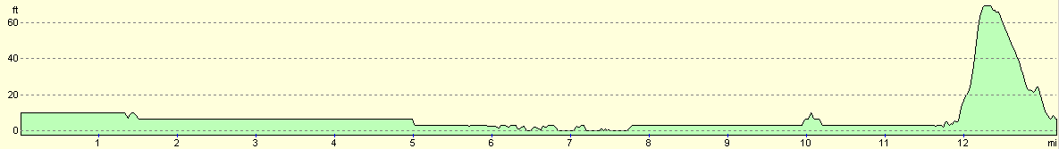
| From | To | Distance (m) | Ascent (ft) | Descent (ft) |
|---|---|---|---|---|
| Waterbeach Station | Dimmock's Cote | 6.5 | 7 | 16 |
| Dimmock's Cote | Ely Station (via the cathedral) | 6.7 | 98 | 92 |
This makes a total distance of 13.2 miles, with 105 feet of ascent and 108 feet of descent.
For more information on profiles, ascents and descents, see this page
Transport
There are regular (even on Sundays) trains from Ely to Waterbeach. The price of a single ticket is £3.00, and it costs £1.00 to park at Waterbeach Station at weekends.
Disclaimer
Please note that I take no responsibility for anything that may happen when following these directions. If you intend to follow this route, then please use the relevant maps and check the route out before you go out. As always when walking, use common sense and you should be fine.
If you find any information on any of these routes that is inaccurate, or you wish to add anything, then please email me.
All images on this site are © of the author. Any reproduction, retransmissions, or republication of all or part of any document found on this site is expressly prohibited, unless the author has explicitly granted its prior written consent to so reproduce, retransmit, or republish the material. All other rights reserved.
Although this site includes links providing convenient direct access to other Internet sites, I do not endorse, approve, certify or make warranties or representations as to the accuracy of the information on these sites.
And finally, enjoy your walking!
Nearby walks
| # | Title | Walk length (miles) |
|---|---|---|
| 2 | Waterbeach to Newmarket Road, Cambridge | 5.4 |
| 3 | Littleport to Downham Market | 14.0 |
| 5 | A short walk around Waterbeach to Car Dyke | 3.0 |
|
|

|