Walk #604: Ilkley to Burnsall Fell
 |
 |
|
General Data
| Date Walked | 30/04/2004 |
| County | West Yorkshire, North Yorkshire |
| Start Location | Ilkley B & B |
| End Location | Burnsall Fell |
| Start time | 09.02 |
| End time | 18.17 |
| Distance | 21.0 miles |
| Description | This was an entertaining if strenuous walk over several moors via Skipton. |
| Pack | Today I carried my 70-litre Craghoppers rucksack, filled with full camping kit, my Westwind tent, my Blue Kazoo sleeping bag and four days food. |
| Condition | I am not the best after this walk, as I was feeling quite nauseous for the last six miles. My body is more or less okay, with my shoulders being surprisingly good although I did get cramp in my upper legs towards the end. |
| Weather | Today was dominated by the wind, which was surprisingly strong all day and especially so on the exposed hilltops. There was no sign of any rain, and it would have been a warm day had it not been for the wind. |
| OS map | Landranger number 104 (Leeds & Bradford, Harrogate & Ilkley) and Outdoor Leisure number 2 (Yorkshire Dales - Southern & Western Areas) |
 |
 |
|
 |
 |
|
Map of the walk
Maps courtesy of Google Maps. Route for indicative purposes only, and may have been plotted after the walk. Please let me have comments on what you think of this new format. For a detailed table of timings for this walk, please see the table file.
Notes
I left the B&B this morning after a large and filling breakfast, supplied by the chatty landlady. As I hoisted my rucksack onto my shoulders it did not feel too heavy, and I started to look forward to the walk ahead of me. I walked the half mile to the railway station, where I ha to take my pack off to readjust it slightly. This was followed by a stiff ascent uphill to the old bathhouse called White Wells, where I got a good view south over the town. The nearly three hundred year old White Wells had a prominent plaque on it stating: "White Wells - Former bath-house built by Squire Middleton for the people of Ilkley in the eighteenth century. Restored by Eric Busby in 1972 - 1974. Opened to the public in 1976".
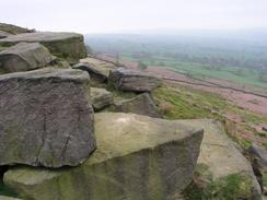
From the bathhouse an obvious and distinct path then led me eastwards, skirting the southern edge of Ilkley Moor towards the Swastika Stone, prominently marked on my map and guarded by sturdy railings, but I could find little of interest except for a strange engraving. Some further investigation when I got home led me to http://rupestre.net/tracce/swastika.html or http://www.stone-circles.org.uk/stone/swastikastone.htm, which have more information on the stone. Ilkley Moor is littered with these cup-and-ring markings, and I visited the nearby Twelve Apostles stone circle on a previous walk. It was a nice stroll and easy going along the path and the views southwards would have been superb in sunny weather, but was less good today, About a kilometre further on I diverted northward across the moorland to gain access to a trig point.
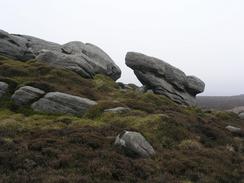
A series of tall stone walls blocked my way from heading directly westwards, so I climbed one before following another southeastwards before eventually reaching a ladder stile over it. I could then follow an easy footpath northwards to the Doubler Stones (also called, rather amazingly, the Great Sacred Mushroom Rock), near where a farm track took me eastwards to a road. These local roads took me to a main road, where I was glad to find that there was a pavement running alongside it, before diving off westwards along another road. A series of footpaths should then have taken me northwestwards, but I found it hard to find this path and therefore headed straight cross-country.
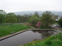
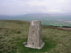
My aim was to find the trig point on Skipton Moor, and when I finally got there I was greeted with marvellous views to the north, only slightly spoilt by the low cloud level. I could clearly see Skipton and Embsay, and also the hillside that I would be climbing later in the day. Unfortunately it was far too windy to stay up by the trig point for too long and I found myself getting very chilly, so I hurried downhill to the west. In my haste I missed the path that I should have taken, and therefore took a longer route down into Skipton via a reservoir.
By the time that I reached Skipton I was feeling fine, and could hardly believe that I had walked so far. I passed the Woolly Sheep Inn, which seemed like a nice place and so I decided to stop off and use the opportunity to have a meal. I went in to what seemed like a fascinating building with low beams and ordered a roast lamb meal, washed down with the Skipton-brewed Copper Dragon. During the meal I started to feel slightly unwell, and so I got a pint of orange and lemonade to try to was down the rest of the meal. This did not work, and I ended up leaving a small amount of the meal and half of the drink.
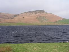
It was market day in Skipton and I quite liked the area around the market, although I was keen to move on so I plodded on out of the town via the side of the prominent castle. The walk along to Embsay was easy and along roads, and the only thing of any real interest to note was the Embsay steam railway that runs alongside the road. A nice road led uphill towards Embsay Reservoir, where the full fury of the wind struck me once again. The wind was making the surface of the water very choppy, and the masts of the boats stored beside the reservoir were swaying.
The next ascent was along a track marked on the map, but this proved hard to find on the ground and so I headed up northwards along a fairly indistinct track. The hillside was quite steep and fairly soon the queasiness that had earlier effected me soon came back to haunt me. I started to feel quite unwell, and I found that I had to stop in a stone shooting butt for a rest, shortly after which I was sick. I was low on water and used what little remained to wash my mouth out, before picking my pack up and heading uphill once more
I managed to regain the proper track by the last shooting butt, and the going was easier as I followed it northwards to two strange turf-roofed huts beside the path. These were filled with a table and benches, and I can only assume that shooting parties uses them for shelter. I had no choice now but to head northwards across the trackless moorland; this is hard going but was made much more so by my condition, which was still distinctly ropey. Eventually I found my way to the obelisk that stands prominently on the northern edge of the moorland, which is a war memorial that has been slightly damaged by people carving into the soft stonework.
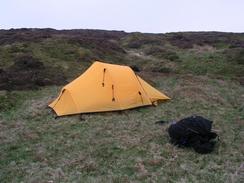
A rough track headed northeastwards from the Obelisk along the northern edge of the moorland, but after about five minutes I started dry retching, and this was followed by being sick for a second time. The wind was highly annoying, and I was glad when the track became more distinct and easier to follow. I had planned to spend the night at a trig point on the highest point of the moor, but I decided that given he wind it may be wiser to find somewhere slightly less exposed, so I eventually settled on a patch of grass just to the south of the track. I took my time putting the tent up, and then dived into my tent, not to emerge until the next morning.
Directions
This walk started off at the B&B that I was stayed in for the night in Ilkley, but I shall started the walk description from the railway station in the town. Leave the railway station and turn to the right to walk eastwards for a couple of yards to an intersection, and then turn to the left to climb uphill along Wells Road. When the road curves to the right take a footpath that continues straight on, angling uphill towards the prominent White Wells. Once at the buildings turn right and follow a stony track that angled downhill to the right; when this track curves to the right continue straight on along a footpath that heads westwards to meet Keighley Road. Cross the road and once on the other side take a footpath that heads westwards, skirting some houses marking the southern edge of Ilkley.
The path eventually becomes more open as it heads westwards along the increasingly craggy northern edge of Ilkley Moor. The path passes the Swastika Stone, and a little over a kilometre further on near the Noon Stone leave the path and turn to the left and climb uphill to the south, aiming to reach the trig point on Long Ridge End. Once at the trig point turn and follow the high stone wall westwards; when the wall divides in a Y' climb the apex and follow the left-hand wall as it heads northwestwards towards Windgate Nick. After a kilometre a ladder stile over the wall is reached; climb this stile and head due south along a footpath across the moorland, aiming for the farm that lies in the shadow of the Doubler Stones.
Once at the farm turn to the right and follow a farm track westwards until it meets a road, and then turn right for a short distance, passing a couple of houses before climbing another ladder stile to gain access to a footpath on the left. Follow this footpath as it heads westwards across fields to a farm, where it turns to head in a more northwesterly direction across more fields, descending into a little valley before climbing up the other side to reach a farm track. Turn left and follow this farm track until it ends at a road. At the road turn right and follow it as it heads northwards, and then northwestwards, to a T-junction with another road. Turn right along this road for a few hundred yards until it curves to the right; here take another road that leads off to the left, heading northwestwards to meet the A6034 road.
Turn right and follow the A6034 road northwards for a few hundred yards until it curves to the right near Cringles, and then take a road that heads off to the left. This road heads northwards before slowly curving onto a more northwesterly direction across Silsden Moor. The road passes a farm on the right as it curves to the left; on the apex of the bend take a footpath that heads off to the right, skirting the edge of the farm as it heads westwards. The footpath joins a track for a short distance before ending at another road; once at this road turn right and follow it uphill towards Carr Bog Farm. Just before the farm is reached turn left and start to walk northwestwards across fields before leaving the enclosed land and entering moorland. Aim to head north of the farm at High Edge and cross a stream, before following the western bank of this stream northwestwards across the moorland to gain access to the trig point at the highest point of Skipton Moor.
From the trig point head westwards along a path that leads towards Jenny Gill; from here a footpath drops off down to the right, but I missed this and continued on southwestwards on the hillside above a reservoir. When a patch of trees called Great Wood Plantation was reached on the right I climbed a fence and headed northwestwards downhill along the edge of the woodland before angling to the right to meet the southern corner of the reservoir. A track led from here to the end of Whinny Gill Road, which I followed northwards to a junction with Greatwood Avenue. Turn right along this for a few yards until it ends at Shortbank Road, and then turn left along this road to follow it downhill to the northwest, passing under a disused rail bridge before ending at the A6069 Otley Road.
Once at Otley Road turn to the left and follow it westwards into the centre of Skipton. At a roundabout turn right and follow the A6131 High Street northwards, passing the market before reaching another roundabout near Skipton Church. Continue on the A6131 as it curves to the right, passing the entrance to Skipton Castle and curving to head eastwards and then northwards. A little under a kilometre out of Skipton Skipton Road leads off to the left, heading northeastwards and passing under the A65(T) before entering Embsay.
Head through Embsay, passing the junction with Brackenley Lane and heading towards the preserved railway station, and then turn left to follow a road uphill to the north. When this ends a T-junction with Pasture Road turn left and follow the road as it heads northwestwards and then northwards towards the dam of Embsay Moor Reservoir. Once the road ends near a car park take a track that heads along the western side of the reservoir to Crag Nook and then turn to the right to go through a gate and join a footpath that heads eastwards slightly above the reservoir. After a few yards turn left and started heading directly northwards uphill; a track is marked on the 1:25,000 Ordnance Survey map but I found this hard to find, and I progressed by using a path that headed uphill past a series of grouse butts.
Near the last shooting butt he track becomes obvious a few yards away to the left; join the track and follow it as it heads northwards. Although the track is rough it is easy going as it skirts East Harts Hill and descends and climbs out of Waterfall Gill. A short distance further on the track reached two wooden turf-roofed huts and curves sharply to the right. Here leave the track and start heading northwards across the moorland of Rylstone Fell, aiming for the Obelisk on Watt Crag, a little over a mile to the north as the crow flies. The going across the moorland is tough, especially on tired legs, but the obelisk is prominent on the skyline and is easy to navigate to.
Once at the obelisk climb a ladders tile over a tall stone wall to gain access to it, and then turn to the right to head northeastwards, keeping the wall to the right. Navigation is easy, and when another ladder stile is reached climb over it and keep walking northeastwards with the wall on your left. The path soon becomes a track that can be followed as it slowly curves to the right to head in a more easterly direction under Spin Well. I camped a short distance away to the east, in a little grassy area a few yards downhill from the track, a few hundred yards northeast of the trig point at the top of the moorland.
Distances
| From | To | Distance (m) | Ascent (ft) | Descent (ft) |
|---|---|---|---|---|
| Ilkley | Skipton | 12.9 | 1985 | 1946 |
| Skipton | Burnsall Fell | 8.1 | 1890 | 738 |
This makes a total distance of 21.0 miles, with 3875 feet of ascent and 2684 feet of descent.
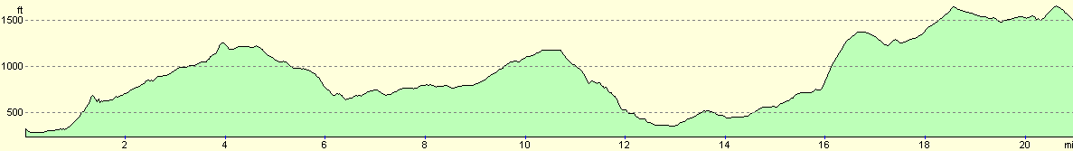
For more information on profiles, ascents and descents, see this page
Accommodation
I spent the night wild camping on Burnsall and Thorpe Fell, a few yards downhill from a rough track and about a third of a mile northeast of the trig point on the moor. The previous night I stayed at the Roberts Family Bed and Breakfast, 63 Skipton Road, Ilkley, West Yorkshire LS29 9HF, telephone 01943 817542. This was an exceedingly nice bed and breakfast run by a very friendly family, and cost me thirty pounds for the night.
Disclaimer
Please note that I take no responsibility for anything that may happen when following these directions. If you intend to follow this route, then please use the relevant maps and check the route out before you go out. As always when walking, use common sense and you should be fine.
If you find any information on any of these routes that is inaccurate, or you wish to add anything, then please email me.
All images on this site are © of the author. Any reproduction, retransmissions, or republication of all or part of any document found on this site is expressly prohibited, unless the author has explicitly granted its prior written consent to so reproduce, retransmit, or republish the material. All other rights reserved.
Although this site includes links providing convenient direct access to other Internet sites, I do not endorse, approve, certify or make warranties or representations as to the accuracy of the information on these sites.
And finally, enjoy your walking!
Nearby walks
| # | Title | Walk length (miles) |
|---|---|---|
| 34 | Ponden to East Marton | 13.4 |
| 35 | East Marton to Malham | 9.2 |
| 97 | Shipley and Baildon Moor circular. | 7.7 |
|
|

|