Walk #603: Bishop's Stortford to Braintree
 |
 |
|
General Data
| Date Walked | 25/04/2004 |
| County | Hertfordshire, Essex |
| Start Location | Bishop's Stortford |
| End Location | Braintree |
| Start time | 09.02 |
| End time | 16.27 |
| Distance | 18.9 miles |
| Description | This was a surprisingly nice walk following a disused railway line eastwards between the two towns. |
| Pack | Today I carried my 70-litre Craghoppers rucksack, which was filled with full camping gear minus food. |
| Condition | I feel absolutely fine after this walk, and I could easily have walked further after a little rest. I have no blisters, and even my shoulders (which usually suffer when carrying my large pack) were fine. |
| Weather | The weather today was lovely; with sunny periods interspersed with some thin cloud cover. There was little wind, and it was one of the hottest days of the year so far. There was no sign of any rain, for which I was quite thankful. |
| OS map | Landranger number 167 (Chelmsford, Harlow & Bishop's Stortford) |
 |
 |
|
Map of the walk
Maps courtesy of Google Maps. Route for indicative purposes only, and may have been plotted after the walk. Please let me have comments on what you think of this new format. For a detailed table of timings for this walk, please see the table file.
Notes
The dawn of another weekend saw me looking forward to be doing another walk. The weather promised to be good, and so it was with no little hardship that Sam drove me down to Bishop's Stortford early this morning so that I could set off on the walk. As I am going away for a four-day backpacking trip next weekend this was my last chance to get my shoulders use to the weight of a full pack, and so sitting on the back seat of the car was my rucksack, fully loaded with all my camping kit excluding the food.
As Sam dropped me off at the station (after negotiating the car park that was surprisingly jam-packed for such an early time on a Sunday morning) I hoisted the rucksack onto my back and became instantly aware of exactly how heavy it was. I was not exactly staggering under the weight, but nonetheless it was a greater weight than I had carried for some time. It was my first time in Bishop's Stortford for several years (indeed, since I last walked here on my sectional Land's End to John O'Groats walk), and I was less than impressed with the place - the area around the station was quite dismal, and I could hardly wait to escape its clutches.
A bridge took me over the railway line and I soon found myself walking along Warwick Road, which was very much an improvement with nice, well-kept houses on either side of the wide road. This soon led me to another road that led me out of the town, and then onto a footpath that took me past allotments before heading over to a bridge over the M11. It was shortly after this bridge that I made the only navigational mistake of the day; at the end of a track I had to choose whether to follow the left- or right- hand side of a hedge, and I mistakenly chose the right side. This led me way off course when it diverted to the right, and I found that I could not squeeze through the hedge with my pack on.
Disgruntled, I went through a gate to find myself on the road a few hundred yards south of where I should have joined it. This was hardly a massive mistake, but it annoyed me nonetheless. Since having crossed the M11 a near-constant stream of planes had come in low overhead, coming in to land at Stansted airport, and as I walked along he road through Tilekiln Green a Jumbo Jet passed very low and I could see the detail underneath the plane in great detail, with the flaps lowered for landing. The noise was ear-bustingly loud, and I wondered how people coped with living directly under the flightpath of the planes.
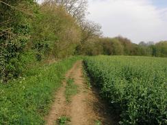
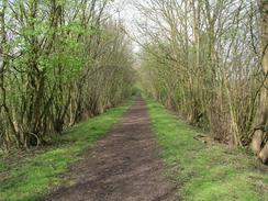
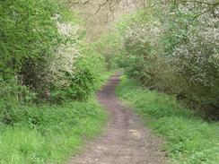
I soon found myself climbing up a steep bank to join the start of the Flitch Way, a path that I would follow eastwards all the way to Braintree at the end of the walk. The path runs along the trackbed of the old Bishop's Stortford to Braintree railway line, which was severed by the M11 and thus the trial only starts in Tilekiln Green, a couple of miles out of Bishop's Stortford. The going was easy, albeit slightly muddy, as I walked along eastwards, passing immediately to the north of Hatfield Forest, where a cargo-carrying Jumbo Jet crashed a few years ago. Beside the path was a fingerpost denoting Epping Forest as being twenty-one miles away along the Three Forests Way path; this is an extremely tempting walk and I can seem myself doing it sometime in the future.
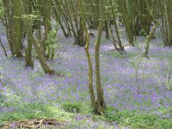
Just to the west of Little Canfield I came across a sign stating that the bridge over the River Rodding was closed, and so I had to divert down onto the busy A120 for a couple of hundred yards before diverting up a road and regaining the path near Little Canfield Church. The rest of the way was easy enough, passing areas with plenty of Bluebells in flowers until I reached a large construction site. This was for the A120 dual carriageway, which looked as though it was relatively complete; most crash barriers were in place and it looked as though only a top layer of tarmac was needed before the road is complete. There was no construction traffic about and so I took my time crossing the road and studying the construction - symptoms of doing a Civil Engineering course years ago!
Not long after crossing the new road I came to the current A120 road, along which a near-continuous stream of traffic was flowing. I had to wait for a few minutes for a cap n the traffic before I could cross, and I then found myself wandering through residential streets in great Dunmow, which I must admit that I was not much taken by. A footpath led through am overgrown area, beside which was an extremely derelict building - the beams on the first floor level had completely broken in two, and from one side the building could not be observed through the dense, overhanging ivy. It made the only sight of interest on my route through the village, and it was a relief when I saw a pub sign just off the B184 road for the Kicking Dickey pub.
After wondering what on earth an Old Dickey is and coming up with no respectable answers, I went into the pub and ordered a pint of Old Bob. As the sun was shining I decided to sit outside, but after five minutes I could hear the gruff tones of Martin Brundle coming through the window and I realised that the Formula One grand prix from Imola was on. This forced me back inside, and I watched the first twenty minutes of the race until Schumacher predictably took the lead from Jenson Button. This was a signal that the race was going to become boring, and so I picked up my rucksack and set off down the B184 road at a tortoise pace when compared to the speed of the cars that I had been watching.
I had to cross the A120 once again before rejoining the Flitch Way near Langleys. I soon crossed the new dual carriageway once more, and walked on along the path. This stretch was quite nice although not beautiful, and near the site of the old station at Felsted the path squeezed past a gypsy camp. Eventually the path approached the village of Rayne, where I could see a new long and sweeping bridge climbing over the new dual carriageway. A sign stated that that Flitch Way was closed, but as the bridge seemed to be complete I decided to walk over it. Unfortunately near the top I could see reinforcing bar sticking up and I was aware that the bridge was not complete and so I had to turn back and join a road for a short distance. This led me to the dual carriageway a hundred yards south of the incomplete footbridge, and I could see that part of the new road was open and in use by traffic. I carefully crossed this road and used an access driveway to regain the Flitch Way.
The path led me past Rayne Station, which has been partially restored and now houses a visitors centre. I did not go into have a look at this but walked on; even though the path passes straight through the middle of Rayne it is in a cutting and seems to be in the middle of the country - the surrounding village hardly encroaches at all. The path led inexorably on, soon entering the western outskirts of Braintree and the townscape soon started encroaching on the path as bridges took me over local roads, the original rail bridges having been replaced with footbridges. The Flitch Way eventually ended by the overspill car park for Braintree station, which was a few yards away. As I sat down and waited for Sam to pick me up I was glad to see that, despite carrying a heavy load, I was not too tired and that if I had needed I could have walked on - a good omen for next weekends walk.
Directions
This walk starts off at Bishop's Stortford railway station. Leave the station and turn to the right to head north for a hundred yards past the car park with the railway to your right; when the road climbs up follow it as it ascends and becomes Station Road as it curves to the right to cross the railway line on a bridge. Station Road soon ends at a T-junction with the A1184 London Road; turn right and follow this road as it heads south for a hundred yards, before turning left to follow Warwick Road as it climbs up a slight hill to the east. Warwick Road eventually ends at a complex junction by some bollards, where you can turn to the right to follow Haymeads Lane as it heads southeastwards, passing a hospital on the way.
Once Haymeads Lane curves to the left take the second footpath off to the right, which heads southeastwards packed in between some allotments before crossing the Hertfordshire / Essex border. The path is easy to follow as it descends down to a stream, where it joins a track that climbs slowly uphill to meet the western side of the M11. Once it meets the M11 it turns to the left for a few yards to reach a bridge over the motorway; cross this bridge and once on the other side follow the track as it heads southeastwards for a few yards before curving to head in a northeasterly direction. The track ends at a junction with another track that leads down to Harps Farm; do not take this track but continue on, making sure that you keep the hedge on your right, otherwise you will get slightly off course as I did.
The footpath ends at the road in Tilekiln Green. Once the road is reached turn to the left and follow it northwestwards for a few yards until a bridge over the road is reached. Here a footpath leads up to the left to join a path at the top of the bridge, and then turn right to start walking eastwards along the path. This path can be followed eastwards for the next seven miles until the outskirts of Great Dunmow is reached, except for a short section immediately to the west of Little Canfield where, due to a weak bridge, the path joins the A120 eastwards for a noisy and nasty hundred yards before diverting back to the path along the road that leads towards the church. On the approach to Great Dunmow you will have to cross the new A120 dual carriageway, which was under construction when I walked this route, before reaching the old A120 on the western side of Great Dunmow.
Cross the A140 road and once on the other side climb up some steps that lead up the side of the cutting a few yards away to the left. The steps lead onto a road, and follow this northward for a short distance until High Fields Road is reached. Turn right and follow this eastward for a few yards before turning to the south down another road until this ends, and then turn left along Woodview Road. When this curves to the left take a footpath that squeezes between houses before heading eastwards across a patch of waste ground, complete with a very nearly disintegrated ivy-clad building, before reaching New Street. When this curves to the left turn right along another lane that curves eastwards before ending at the B184 High Street.
Turn to the right and follow the B184 as it heads southeastwards, crossing the A120 on a bridge and passing a triangular junction with Ongar Road. Continue on until the road eventually ends at the A120; cross this and once on the other side start heading down a driveway that leads towards the farm at Langleys. A few yards down the driveway enter a field to the right and follow the edge of a field to some steps that lead up the embankment to rejoin the old railway line beside an old bridge. Turn right and follow the trail that runs along the top of the embankment eastwards; it soon re-crosses the new dual-carriageway road (again, not open when I passed), and heads onwards for a little under five miles until the new dual carriageway is crossed once again.
Here a new and sweeping bridge, sadly not commissioned when I passed, leads over the A120 and down the other side to enter the little village of Rayne. The path passes the old station, which has been partially restored, and onwards through the centre of the village, although this is scarcely seen from the path. Eventually the path crosses the B1256 road and enters the western outskirts of Braintree and is very easy to follow as it heads through the town, crossing a couple of other roads on bridge before eventually ending at an overspill car park next to Braintree railway station, where this walk ends.
Distances
| From | To | Distance (m) | Ascent (ft) | Descent (ft) |
|---|---|---|---|---|
| Bishop's Stortford | Great Dunmow | 9.9 | 459 | 420 |
| Great Dunmow | Braintree | 9.0 | 305 | 377 |
This makes a total distance of 18.9 miles, with 764 feet of ascent and 797 feet of descent.
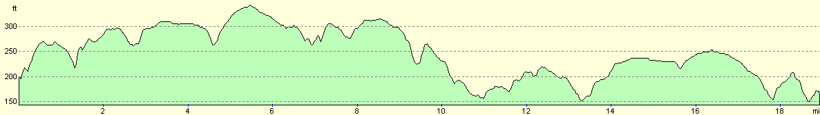
For more information on profiles, ascents and descents, see this page
Transport
There are some bus services between Braintree and Bishop's Stortford, apparently run by Olympian Coaches in Harlow along Route 741, although I have not been able to find any further information on them as I did not need to use them - my girlfriend picked me up from the end of the walk.
Disclaimer
Please note that I take no responsibility for anything that may happen when following these directions. If you intend to follow this route, then please use the relevant maps and check the route out before you go out. As always when walking, use common sense and you should be fine.
If you find any information on any of these routes that is inaccurate, or you wish to add anything, then please email me.
All images on this site are © of the author. Any reproduction, retransmissions, or republication of all or part of any document found on this site is expressly prohibited, unless the author has explicitly granted its prior written consent to so reproduce, retransmit, or republish the material. All other rights reserved.
Although this site includes links providing convenient direct access to other Internet sites, I do not endorse, approve, certify or make warranties or representations as to the accuracy of the information on these sites.
And finally, enjoy your walking!
Nearby walks
| # | Title | Walk length (miles) |
|---|---|---|
| 49 | Bishop's Stortford to Great Chesterford | 14.9 |
| 53 | Harlow Town to Bishop's Stortford | 9.8 |
| 630 | Braintree to Marks Tey | 14.4 |
|
|

|