Walk #34: Ponden to East Marton
 |
 |
|
General Data
| Date Walked | 11/08/1999 |
| County | West Yorkshire, North Yorkshire |
| Start Location | Ponden |
| End Location | East Marton |
| Start time | 08.00 |
| End time | 16.15 |
| Distance | 13.4 miles |
| Description | This was a highly pleasant walk, the high point being some superb views from the top of Pinhaw Beacon. |
| Pack | Today I carried full camping gear. |
| Condition | My legs are fine, and my feet are fine. My back, however, is agony. After one very good day, this afternoon after lunch in Lothersdale it became very, very bad. It is perhaps almost as bad as it was after the second day. |
| Weather | Today started off cloudy, but after lunch it became much brighter with perhaps about 50% of the sky cloudy. The best day so far. |
| OS map | Outdoor Leisure number 21 (South Pennines) |
Map of the walk
Maps courtesy of Google Maps. Route for indicative purposes only, and may have been plotted after the walk. Please let me have comments on what you think of this new format. For a detailed table of timings for this walk, please see the table file.
Notes
Today was quite a reasonable day. An early start from Ponden allowed me to get to Lothersdale by mid-day. Since I did not have much tea last night or this morning I stopped of at the pub, and the meal I had at Lothersdale came in very handy.
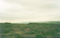
The highlight of the day was the spectacular view from the top of Pinhaw Beacon. I will definitely have to go up there again some day for another look. The views came as a complete surprise, and I was amazed to see a long way across North Yorkshire to the high hills.
By the time that I finished I was glad to have yet another day under my belt, with the knowledge that another day will come easily. I await with trepidation the Pen-y-ghent section, which promises to be strenuous, but I am also quite looking forward to it.
My confidence is still fairly high, and I believe that I could still finish if my back can heal. I hold a fair bit of hope of this, as my lower back which was causing me trouble earlier in the walk is now okay, and hopefully the same thing will happen to my upper back.
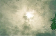
There has been a great deal of media hype over the total eclipse that took place in Cornwall this morning. I got a reasonable few glances at it when the clouds parted, but I was far too far north to get anything like totality. I took a photo of the eclipse right at the end, and when many clouds were out. It will probably be just a blur of cloud.
My back is *very* bad. It became bad coming down from Pinhaw Beacon. I am starting to believe that the initial damage was done by the incorrectly fitted pack, but the new irritation is being caused by sweat. The initial damage was on the lower part of my back, and that is now okay. The new pain is from my middle back between my shoulders and my waist.
I will have to do something about this. There is a chemists in Cargrave and I will call in there tomorrow on the short day and see if they can give me anything for it, e.g. some wide bandages / plasters / strapping. If it does not improve I do not fancy my chances much for the Penyghent section the day after next.
Directions
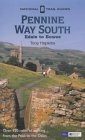
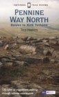
I am not going to bother giving any directions for any of the stages of the Pennine Way; there are many route descriptions produced that will better anything that I could produce. The main guides I used were the OS National Trail Guides, which come complete with strip maps of the route. Click on one of the links below to go to the Amazon page for each guide.
|
| 
|
| |
| |
Distances
| From | To | Distance (m) | Ascent (ft) | Descent (ft) |
|---|---|---|---|---|
| Ponden | Cowling | 5.6 | 1010 | 1207 |
| Cowling | Thornton-in-Craven | 6.2 | 1322 | 1509 |
| Thornton-in-Craven | East Marton | 1.6 | 243 | 210 |
This makes a total distance of 13.4 miles, with 2575 feet of ascent and 2926 feet of descent.
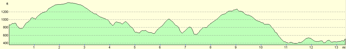
For more information on profiles, ascents and descents, see this page
Disclaimer
Please note that I take no responsibility for anything that may happen when following these directions. If you intend to follow this route, then please use the relevant maps and check the route out before you go out. As always when walking, use common sense and you should be fine.
If you find any information on any of these routes that is inaccurate, or you wish to add anything, then please email me.
All images on this site are © of the author. Any reproduction, retransmissions, or republication of all or part of any document found on this site is expressly prohibited, unless the author has explicitly granted its prior written consent to so reproduce, retransmit, or republish the material. All other rights reserved.
Although this site includes links providing convenient direct access to other Internet sites, I do not endorse, approve, certify or make warranties or representations as to the accuracy of the information on these sites.
And finally, enjoy your walking!
This walk was mentioned in the following routes:
| My sectional Land's End to John O'Groats walk |
| My Pennine Way Walk, 07th to 26th August 1999 |
Nearby walks
| # | Title | Walk length (miles) |
|---|---|---|
| 33 | Mankinholes to Ponden | 12.7 |
| 35 | East Marton to Malham | 9.2 |
| 604 | Ilkley to Burnsall Fell | 21.0 |
|
|

|