Walk #420: Hale to Crosby
 |
 |
|
General Data
| Date Walked | 21/04/2003 |
| County | Cheshire, Merseyside |
| Start Location | Hale |
| End Location | Seaforth |
| Start time | 09.43 |
| End time | 17.04 |
| Distance | 19.5 miles |
| Description | This was a fairly awful walk, with little to redeem it. The walk passes through some grotty areas, and I am very glad that it is over. |
| Pack | Today I carried my 30-litre Karrimor HotRock rucksack, which was filled with my packed lunch, waterproof leggings, water bottle and a couple of spare shirts, together with the usual assortment of odds and ends. |
| Condition | I wore my third pair of boots for the first stretch of this walk, and when I met Sam I was forced to change into trainers as the inside of my right ankle was aching. This is annoying, and I am getting slightly concerned that this problem, which I have had since Pembrokeshire, is not getting better. It does not happen with my trainers or my second pair of boots, but it does with my third pair. Aside from this I had no other problems, which I am quite glad about. |
| Weather | After well over a month with no significant rainfall whilst I have been walking, today it rained. The forecast had been for heavy rain, so for the first time in ages I set off with waterproof leggings on. It rained slightly for a short period early on, but this was soon replaced with a mixture of sunshine and cloud. There was not much wind, and so I soon started to overheat. About an hour from the end of the walk there was an extremely heavy shower, with rain bouncing off the pavement. Fortunately this did not last too long, and the sun came out afterwards so that I was mostly dry by the time that I reached Mervan. |
| OS map | Landranger number 108 (Liverpool, Southport & Wigan) |
 |
 |
|
 |
 |
|
Map of the walk
Maps courtesy of Google Maps. Route for indicative purposes only, and may have been plotted after the walk. Please let me have comments on what you think of this new format. For a detailed table of timings for this walk, please see the table file.
 |
 |
|
Notes
The rain was falling when I woke up this morning, and I therefore delayed my start so that I would miss the worst of it. I used the time quite well, doing some more notes for my website and generally relaxing. This was very much needed, as I have increased the mileage that I do each day over the last few weeks, and I am getting fairly fatigued.
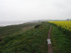
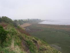
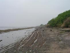
The Ordnance Survey map shows a track running between Liverpool airport and the edge of the cliff, and as someone had told me yesterday that it was possible to walk along it I decided to do so. I am still unsure about whether this was wise; a far easier walk would have been to go around the airport, but the track was nearer to the bank of the estuary. Unfortunately the track was just a narrow path on the ground, and by the time that I reached the runway approach lights the cliff had eroded as far as the fence (indeed, some parts of the airport fence were down the cliff). I therefore had to divert onto a track that ran along the bottom of the cliffs. This was fairly firm and not too boggy, but if the tide is high it could well be impassable, so this should be borne in mind when planning the route. Where the path along the top of the cliffs ended there was a gap in the airport fencing, and it may be possible to walk along the edge of the airport. There were no signs prohibiting entry, but I did not fancy doing it.
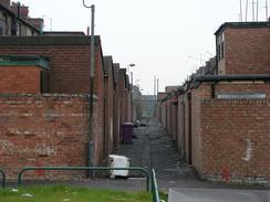
I met Sam by the church in Garston, which was a fairly grotty area. There were a couple of broken bottles on the pavement, and although there were a few new houses there were also some very decayed but still inhabited streets of council houses. The whole area was very depressing; I had the feeling that if you lived there you must have access to a car in order to be able to escape. I nipped into Mervan and changed from my boots into my trainers; my boots had been hurting my right ankle, and so I decided that it was best to try to reduce these problems.
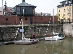
The next part of the walk was along the promenade that heads all the way into the centre of Liverpool from Cressington. The promenade also acts as a cycle path, and it was quite busy with walkers and cyclists as I walked past. The cloud was quite low, and I could only just make out the buildings and cranes on the other bank of the river. The promenade was quite boring for most of the way, but as time went on I approached the site of the 1984 Garden Festival and it improved. By the time that I reached the entrance to the Brunswick Docks I was on a roll, and I was striding on quite well. At the gates leading to the dock, however, some sailing boats were going out onto the river and the pedestrian bridge was raised. Some people were waiting, but as time went by it became obvious that there was something wrong. The sailing club offices overlooked the scene, and they said that the bridge was stuck in the raised position. There was another bridge available over the other lock gate, but this was stuck between two locked gates. The people at the yacht club said that they did not have the keys for the gates. As time dragged by it became obvious that nothing was being done about the situation, so I shouted across for permission to climb over the fences and gates. The first gate was the most difficult to deal with, but I managed to get over with minimal problems and a little thought. I got around the second by balancing precariously over the lock, my back and rucksack, but this left me on the wrong side of another fence. A quick climb and I was in the right place, and as I left someone called down from the club congratulating me on the exhibition! I must admit I quite enjoyed this unorthodox little diversion, which is unusual as I am someone who is adverse to taking risks in life.
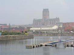
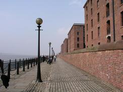
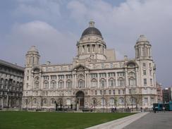
I must admit that I found Liverpool to be a bit of a disappointment. The area around Albert Dock was very nice, and the Liver Building was an absolutely superb piece of architecture when viewed from the riverfront. When I moved to the front of the building, however, the view was very different, an ugly collection of buildings that were totally out of place. It really is a shame - they have obviously spent a great deal of time and money getting the riverfront looking nice, but surely the area around a building that symbolises Liverpool as much as the Liver Building should be a focal point of the city, and not a dump.
I was glad to get out of the city, and I walked north along a dinghy road north past the docks. Some of the old industrial docks building were large and grand, but decay was everywhere. At one point the road was partially blocked by an ambulance and two police cars, between which was a car on its roof in the centre of the road. It was only when I got further north and approached the container docks that the situation improved. One nice thing about this walk was that I passed a walking shop, Outdoor World, and I nipped inside for five minutes to have a look around. I did not need to buy anything, but I just enjoy looking around walking shops to see what kit they have in. Also on this stretch of the walk there was a very heavy shower, and the rain was bouncing off the pavement. I got quite wet during this, but in a strange way I found it to be quite refreshing. It was the first heavy rainstorm that I have walked through for over five weeks, and I could felt as though the rain was in some way cleansing me as it hit me.
I very much hope that tomorrow is a better day, both in terms of weather and in scenery. I can easily cope with a day like today every so often, but a long string of them together would be exceedingly depressing.
Directions
This walk starts off by Hale Church. Leave the church and turn right for a few yards, before taking Within Way off to the right. When this road ends continue on along a footpath that brings you out onto the northern bank of the River Mersey. Here another footpath leads off to the right and curves around to reach the lighthouse at Hale Head before continuing on northwestwards. A path continues on along the southern bank of the river past Liverpool John Lennon airport, but this disappeared and I had to walk along the foreshore, so you may find it best to pick an inland route to the north of the airport. The path emerged at a road on the southeastern side of Garston, and I walked through the town towards the church.
Follow the road past Garston Church as it heads under the A561 and then turn left down St Mary's Road. This road passes a supermarket and continues on until it eventually meets the A561 once more. Pass Cressington Church and continue on and then turn left down Riversdale Road. This leads southwestwards back towards the riverbank and a car park, from where a promenade heads off too the northwest along the riverbank. Follow this promenade all the way into the centre of Liverpool, passing Albert Dock until it reaches the Royal Liver Building., here head inland to the other side of the Liver Building and turn left down a road, before almost immediately turning left down the A5036 road, This road heads northwards through the docks are for a couple of miles before turning to the right to rejoin the A565 road.
Turn left and follow the A565 road northwards, Pass the junction with the A5036 road and then take Cambridge Road, which heads off to the left. The road skirts the northern edge of the container depot, and when it ends continue straight on into a car park beside the Marine Lake in Seaforth, where this walk ends.
Distances
| From | To | Distance (m) | Ascent (ft) | Descent (ft) |
|---|---|---|---|---|
| Hale Church | Garston Church | 7.6 | 502 | 489 |
| Garston Church | Royal Liver Building | 6.2 | 259 | 292 |
| Royal Liver Building | Seaforth | 5.7 | 151 | 164 |
This makes a total distance of 19.5 miles, with 912 feet of ascent and 945 feet of descent.
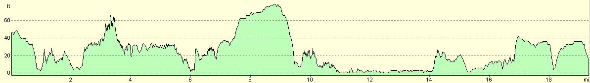
For more information on profiles, ascents and descents, see this page
Accommodation
We parked Mervan in the car park beside the marine lake in Seaforth, which was not near any facilities but was okay to park in for the evening.
Disclaimer
Please note that I take no responsibility for anything that may happen when following these directions. If you intend to follow this route, then please use the relevant maps and check the route out before you go out. As always when walking, use common sense and you should be fine.
If you find any information on any of these routes that is inaccurate, or you wish to add anything, then please email me.
All images on this site are © of the author. Any reproduction, retransmissions, or republication of all or part of any document found on this site is expressly prohibited, unless the author has explicitly granted its prior written consent to so reproduce, retransmit, or republish the material. All other rights reserved.
Although this site includes links providing convenient direct access to other Internet sites, I do not endorse, approve, certify or make warranties or representations as to the accuracy of the information on these sites.
And finally, enjoy your walking!
This walk was mentioned in the following routes:
| My walk around the coastline of Britain |
Nearby walks
| # | Title | Walk length (miles) |
|---|---|---|
| 418 | Hoylake to Ellesmere Port | 20.0 |
| 419 | Ellesmere Port to Hale | 20.5 |
| 421 | Seaforth to Southport | 20.0 |
|
|

|