Walk #419: Ellesmere Port to Hale
 |
 |
|
General Data
| Date Walked | 20/04/2003 |
| County | Cheshire |
| Start Location | Ellesmere Port |
| End Location | Hale |
| Start time | 08.17 |
| End time | 17.20 |
| Distance | 20.5 miles |
| Description | This walk took me across to the northern bank of the River Mersey, and on to the village of Hale. |
| Pack | Today I carried my 30-litre Karrimor HotRock rucksack, which was filled with my packed lunch, waterproof leggings, water bottle and a couple of spare shirts, together with the usual assortment of odds and ends. |
| Condition | I feel absolutely fine after this walk, and I could have walked further if I had needed to. The problem with the left-hand side of my right ankle recurred, but after I took my boots off this stopped. Otherwise I had no other problems, which I am quite glad about. |
| Weather | The weather today was less windy than yesterdays, although there was more cloud about. There were sunny periods, however, and these helped to warm me up. By recent standards it was a cold day, and so I was glad of any warming influence. The promised rain failed to materialise, although it did drizzle for a couple of short periods. |
| OS map | Landranger number 117 (Chester & Wrexham, Ellesmere Port) and Landranger number 108 (Liverpool, Southport & Wigan) |
 |
 |
|
 |
 |
|
Map of the walk
Maps courtesy of Google Maps. Route for indicative purposes only, and may have been plotted after the walk. Please let me have comments on what you think of this new format. For a detailed table of timings for this walk, please see the table file.
Notes
This was a fairly boring walk, with not much really to redeem it. Part of the walk passed right through the middle of the Shell Stanlow refinery complex, which can hardly be called the most scenic place in the world, and much of the walk was on roads. Despite this I tried to get as many small nuggets of enjoyment out of the walk as I could. I found the Stanlow refinery quite interesting - the stalls where they fill up petrol lorries were right by the fence, and I was amazed by the maze of pipes needed to do this.
I met Sam in Frodsham near the station, and as there was still over an hour until the grand prix was due to begin I decided to walk further. Watching the grand prix was not a necessity, but I was quite keen on the idea. I was also concerned about whether or not it was possible to cross over the Runcorn Bridge or not, so we arranged to meet on the outskirts of Runcorn. Whilst I was walking Sam drove over the bridge and bank, and saw that there was a footpath on the upstream side that I could cross on. I reached Mervan about eight minutes before the race began, which was just right for me to relax and get a drink. The race itself was fairly unexciting, and I could easily have missed it with no bother. It did make for a long lunch break however, which was no bad thing.
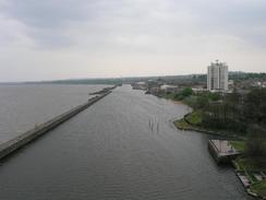
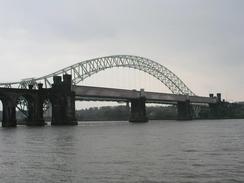
I was unsure about how I could gain access to the south end of the Runcorn Bridge, so I walked around a spiral access ramp along a main road to reach the southern end of the bridge. When I got there I discovered that the footpath went up an access ramp to the right, so I had to cross the road to gain access to it. The bridge itself is absolutely lovely, with cables suspending the road deck from a quite elegant steel arch above. Beside the bridge is a long rail bridge to the left and this could not be of a more different design, it being a tubular bridge. I seem to recall from the depths of my brain that Runcorn used to be the site of the third British transporter bridge, but I could see not sign of this and my memory could be faulty. The Runcorn Bridge opened in 1961 at a cost of three million pounds, and has a length of 1,082 feet. When it opened it was the longest single-span bridge in Europe and the third-longest in the world. It shows just how bridge construction has improved over the years that I did not find the length of the bridge very spectacular as there are far longer bridge in this country nowadays.
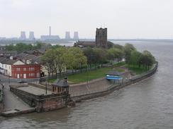
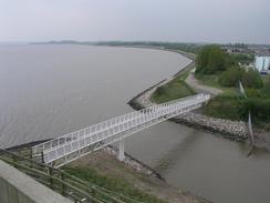
On the other side of the bridge I dropped down and joined a cycle path that runs along the side of the river. This gave some nice views across the river back towards Runcorn and the bridge, and I enjoyed this walk. The path then diverts inland to meet a road that it followed all the way into the village of Hale. By the tie that I reached the village I really needed to go to the toilet, so I nipped into the Wellington pub so that I could use their facilities. Once I had left I walked past the house that use to belong to John Middleton, known as the 'Childe of Hale', who was born in 1578 and grew to a height of nine feet three inches. There are many legends associate with him, but he was definitely a wrestler in King James I's court. This evening I went into the church to have a look at his grave, which has railings around it. The grave does not look overly large, and I wonder if he could really have been over nine feet tall - people back then were generally shorter that they are nowadays (just look at the height of doorways on houses of the period), so someone who was, for instance, seven feet tall would be a giant for those times.
Tomorrow promises to be a more interesting day as I walk up the eastern bank of the Mersey through Liverpool. I am unsure about how I am going to get past Liverpool airport - the Ordnance Survey map shows a track running between the river and the airport, and a local has told me that you can walk along it, but if this is incorrect then I could have a long walk back to get around it. I have decided to attempt it anyway, as the local man said that he regularly walked that way.
Directions
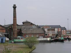
This walk starts at the car park of the Rivacre Country Park beside the B5132 on the western outskirts of Ellesmere Port. Leave the car park and turn left to head southeastwards down the B5132. At a junction turn right to head south for a short distance to a roundabout. At the roundabout turn left to head eastwards, passing a cemetery on the left before climbing up to a roundabout at Junction 8 of the M53. At the roundabout continue straight on to join the A5032 road that immediately curves to the right to head southeastwards alongside the M53. After a kilometre Junction 9 of the M53 is reached; continue on along a minor road that passes a boat museum before running alongside the M53 for a shrt ditsance. It then curves to the left to head eastwards.
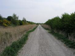
The road heads on for about three miles through the Stannlow oil refinery complex, passing Stanlow and Thornton Station. When the road ends at a roundabout turn left to walk up towards Ince Church. At a T-junction turn left along Marsh Lane, which passes the village pub before descending down to head eastwards across the Ince Marshes. The road curves around before ending and a track heads eastwards, skirting the edge of a factory complex as it becomes Lordship Lane. It crosses the Hornsmill Brook, and about a kilometre east of the brook I took a footpath that headed off to the left along a track Called Cross Lane that climbed up to the top of a bank. After a few hundred metres there is a junction; take a track off to the right called Moreditch Lane that curves around and heads eastwards, eventually joining another track that leads to a bridge over the M56. Cross the bridge and follow the road on the other side, which ends at the A56(T) road in Frodsham.
Turn left and follow the A56(T) northeastwards through the town, passing the station. The road leaves the town and crosses the River Weaver and then the Weaver Navigation. Immediately after the last bridge turn left down the A557 road. This road passes under the railway line and then becomes a dual carriageway as it passes junction 12 of the M56. Continue along the A557 as it heads northwestwards towards Runcorn. Here you could take a more seaward route by following the road around the western side of the town; I chose to avoid the walk around the dual carriageway and took a slip road that headed off to the left near Clifton Hall.
This slip road curved under the dual carriageway until a junction controlled by traffic lights is reached. At this junction turn left down a road that heads northwestwards along Clifton Road through the centre of the town. The road passes Runcorn golf course on the left and at a crossroads becomes Moughland Lane before ending at a T-junction. Turn right at this junction and follow Greenway road as it passes over a railway line and a cemetery on the right. When a slip road leads off to the left take this road as it curves around to the right and climbs up to the Runcorn bridge. The pedestrian pavement is on the right hand side of the bridge, so you will need to carefully cross over the road to gain access to it.
On the northern side of the bridge continue on until some steps lead off to the right. Go down these steps and head under the road to the western side. Turn left to head south between the road and the railway line before turning right to head under the arches of the railway line. Once the river is reached follow a cycle path called the Trans Pennine Trail westwards. The path descends to a bridge over the Ditton Brook before continuing on past a car park. The path turns to the right to head northwestwards and ends at a road. Turn left along this road and follow it southwestwards into the village of Hale, and when it ends at a T-junction turn left down another road that leads to the church, where this walk ends.
Distances
| From | To | Distance (m) | Ascent (ft) | Descent (ft) |
|---|---|---|---|---|
| Ellesmere Port | Frodsham | 11.1 | 207 | 236 |
| Frodsham | Hale | 9.4 | 692 | 689 |
This makes a total distance of 20.5 miles, with 899 feet of ascent and 925 feet of descent.
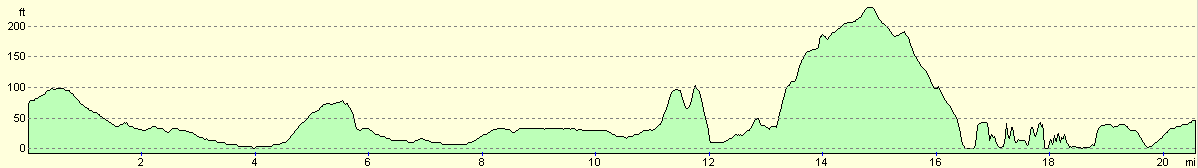
For more information on profiles, ascents and descents, see this page
Accommodation
We parked Mervan outside Hale Church, which was not a bad place to park for the night. The nearest pub, the Child of Hale, was a short stagger up the road, and the road itself was quite quiet. The worst thing about this parking place was the bells of the church, which chimed every hour and annoyed me slightly when they woke me up.
Disclaimer
Please note that I take no responsibility for anything that may happen when following these directions. If you intend to follow this route, then please use the relevant maps and check the route out before you go out. As always when walking, use common sense and you should be fine.
If you find any information on any of these routes that is inaccurate, or you wish to add anything, then please email me.
All images on this site are © of the author. Any reproduction, retransmissions, or republication of all or part of any document found on this site is expressly prohibited, unless the author has explicitly granted its prior written consent to so reproduce, retransmit, or republish the material. All other rights reserved.
Although this site includes links providing convenient direct access to other Internet sites, I do not endorse, approve, certify or make warranties or representations as to the accuracy of the information on these sites.
And finally, enjoy your walking!
This walk was mentioned in the following routes:
| My walk around the coastline of Britain |
Nearby walks
| # | Title | Walk length (miles) |
|---|---|---|
| 417 | Shotton to Hoylake | 19.0 |
| 418 | Hoylake to Ellesmere Port | 20.0 |
| 420 | Hale to Crosby | 19.5 |
|
|

|