Walk #418: Hoylake to Ellesmere Port
 |
 |
|
General Data
| Date Walked | 19/04/2003 |
| County | Merseyside, Cheshire |
| Start Location | Hoylake |
| End Location | Ellesmere Port |
| Start time | 09.05 |
| End time | 17.51 |
| Distance | 20.0 miles |
| Description | This walk took me along the north coast of the Wallasey peninsular, before heading down the western bank of the Mersey. |
| Pack | Today I carried my 30-litre Karrimor HotRock rucksack, which was filled with my packed lunch, waterproof leggings, water bottle and a couple of spare shirts, together with the usual assortment of odds and ends. |
| Condition | I feel absolutely fine after this walk, and have no major problems to report. I could easily have walked further if I had needed to, but there was no real need to. |
| Weather | Today was quite radically different to the previous few days. It was cloudier, although there were lengthy breaks in this that allowed the sun through, and it was far cooler. The worst thing, however, was the brisk northeasterly wind that was very cold, and was exceedingly annoying when I was walking northeastwards this morning, as it was a headwind. There was no sign of any rain making this yet another dry day, although the forecast is for rain tomorrow. |
| OS map | Landranger number 108 (Liverpool, Southport & Wigan) and Landranger number 117 (Chester & Wrexham, Ellesmere Port) |
 |
 |
|
 |
 |
|
Map of the walk
Maps courtesy of Google Maps. Route for indicative purposes only, and may have been plotted after the walk. Please let me have comments on what you think of this new format. For a detailed table of timings for this walk, please see the table file.
Notes
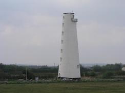
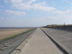
This was a walk that I had not really been looking forward to it, but it was not as bad as I had expected it to be. The walk between the Dee and the Mersey estuaries was not bad, as it was along promenades and seawalls, with some lovely views available out to sea. The Leasowe Lighthouse is halfway along this stretch, and it now stands well inland and is disused. The sandbanks in this area cost many ships, but the sands were too unstable to allow a tower to be built. In 1761 a ship carrying a load of cotton ran aground, and the cargo was abandoned on the beach to rot. The salt water turned the bales of cotton into a hardened raft, on which the base of the tower was built. The fact that the lighthouse is now inland shows how building seawalls has reclaimed land.
As I was walking along this stretch an attractive lady came jogging up behind me. She stopped to talk to me, and said that she had read the banner that is on the back of my pack. We chatted for a few minutes, and I commented that she was wearing the same sort of top as me, to which she replied that it looked better on me than it did on her! She also said that she would give me a little donation, and as she was wearing just a running top and shorts I wondered where she would get it from. She leant down and pulled out a slim plastic bag from inside her sock and got a coin out and put it in my collection pot - she says she used the money pay for a bus fare if it started raining whilst she was out on a run. This is the sort of time when I have to tell myself very hard that I am going out with Sam, and to form my comments accordingly!
I met Sam in Mervan by the ventilation shafts of one of the Mersey Tunnels, just down the road from the Seacombe Ferry. I had not yet seen one of the new-style Formula One grand prix qualifying session from San Marino this season, so I decided to wait and watch it. This meat a two-hour lunch break whilst I watched it, during which I completed the write up of two more walks. I was not too bothered about the time wasted, as I had kept up a decent pace during the morning, so I only had a couple of hours of walking to do to reach my average of sixteen miles. I may well do the same thing tomorrow, and take a long lunch break so that I can watch the main race.
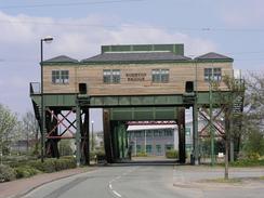
The walk through Birkenhead was not as bad as it could have been, although I did get myself trapped on the dual carriageway A41. There was no pavement beside the road, so I decided that it would be best to walk along the adjacent main road that is slightly inland as it would be safer. Unfortunately the A41 had palisade fencing stopping you from leaving it, so I had to wait until I found a place where I could climb it. This opportunity came where a pedestrian underpass went under the road, and there was a stretch of lower fencing that I could easily climb over. The other road led me past Port Sunlight, the famous garden village founded by the first Lord Leverhulme in 1888, the owner of the Lever soap company. The village consists of 900 houses and public buildings for the workers, and was well ahead of its time.
I met Sam again at the car park of Eastham Country Park, and as I had only done a little over sixteen miles I decided to walk on further. The next place to meet was at the Rivacre Valley Country Park on the western side of Ellesmere Port, so this was where we arranged to meet. This stretch of the walk was again fairly boring, with little of interest as the road I walked along skirted the M53.
Tomorrow promises to be a very boring walk, as I have to walk eastwards skirting the southern side of the Manchester Ship Canal to reach Runcorn. I am hoping that I will be able to cross the Mersey at the Runcorn Bridge, and if this is not possible then I will have to do a much longer walk to cross the river. The walk will pass an oil refinery, so it is most certainly not going to be a classic walk.
Directions
This walk starts off at the western end of the promenade in Hoylake. Head eastwards along the promenade through the town, and when it ends continue on along a broad track at the top of the seawall. Near the Leasowe Lighthouse a cycle path begins, and this can be followed as it passes Mockbeggar Wharf and enters Wallasey.
The path sticks right to the sea until the marine lake in New Brighton is reached. Continue on the seaward side of the lake until the fort at Perch Rock is reached, and then follow the river around to head southwards along another promenade for a couple of miles until the Seacombe ferry terminal is reached. At the terminal head inland along the road and then head southwestwards along tre A554 road to reach the A5139 road, which crosses over the East Float on two bridges.
At a roundabout by the second bridge turn left down the A554 and follow it as it heads to the south of the docks through Birkenhead. It curves to the right and becomes the A41 as it passes near the remains of a priory, and when this curves around to the left slightly it would be best to continue on along another road that heads south through Rock Ferry and Port Sunlight before rejoining the A41 at a roundabout (I tried walking on along the A41 dual carriageway which is a more seaward route, but it was a busy road and not a very nice walk).
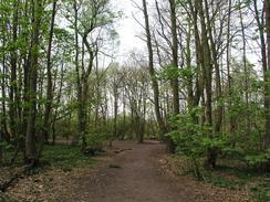
Continue on down the A41 until Pool Lane is reached on the left near the Village Hotel and Leisure Club in Bromborough Pool. Turn left down this road and follow it as it curves around to the right twice, before taking a road off to the left. This road heads straight on southeastwards until a roundabout is reached. Continue straight on down an old road for about a hundred yards, before taking a footpath that heads off to the left and leads eastwards through some woodland to a car park at the Eastham Country Park.
Leave the car park and head southwards down the road until it curves to the right and ends at a T-junction with a road in Eastham. Turn left down this road for a short distance towards the church and then turn left down the B5132 Rivacre Road. Continue on this road as it heads over the M53 near junction 6 and continue on for another mile until the car park for the Rivacre Country Park is reached, where this walk ends.
Distances
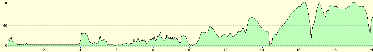
| From | To | Distance (m) | Ascent (ft) | Descent (ft) |
|---|---|---|---|---|
| Hoylake | Perch Rock | 7.2 | 125 | 128 |
| Perch Rock | Port Sunlight | 6.9 | 404 | 381 |
| Port Sunlight | Rivacre Valley, Ellesmere Port | 5.9 | 312 | 276 |
This makes a total distance of 20.0 miles, with 841 feet of ascent and 785 feet of descent.
For more information on profiles, ascents and descents, see this page
Accommodation
We parked Mervan in the car park of the Rivacre Country Park for the night, which meant that I can start tomorrow's walk here early if necessary.
Disclaimer
Please note that I take no responsibility for anything that may happen when following these directions. If you intend to follow this route, then please use the relevant maps and check the route out before you go out. As always when walking, use common sense and you should be fine.
If you find any information on any of these routes that is inaccurate, or you wish to add anything, then please email me.
All images on this site are © of the author. Any reproduction, retransmissions, or republication of all or part of any document found on this site is expressly prohibited, unless the author has explicitly granted its prior written consent to so reproduce, retransmit, or republish the material. All other rights reserved.
Although this site includes links providing convenient direct access to other Internet sites, I do not endorse, approve, certify or make warranties or representations as to the accuracy of the information on these sites.
And finally, enjoy your walking!
This walk was mentioned in the following routes:
| My walk around the coastline of Britain |
Nearby walks
| # | Title | Walk length (miles) |
|---|---|---|
| 415 | Rhos-on-Sea to Point of Ayr | 19.9 |
| 417 | Shotton to Hoylake | 19.0 |
| 419 | Ellesmere Port to Hale | 20.5 |
|
|

|