Walk #334: Antony to Freathy
 |
 |
|
General Data
| Date Walked | 22/01/2003 |
| County | Cornwall |
| Start Location | Antony |
| End Location | Freathy |
| Start time | 08.05 |
| End time | 16.38 |
| Distance | 20.7 miles |
| Description | This was a long walk of two halves; an initial stroll around the last part of Plymouth Sound was followed by a far better walk along the coastal path past Rame Head. |
| Pack | Today I carried my 30-litre Karrimor HotRock rucksack, which was filled with my packed lunch, waterproof leggings, water bottle and a couple of spare shirts, together with the usual assortment of odds and ends. |
| Condition | I feel absolutely fine after this walk, and could easily have waked further if I had needed to. |
| Weather | Today's weather was a mixture of sunshine and cloud, and fortunately it did not rain at all during the day. It was slightly colder than yesterday, and in exposed places such as Rame Head the wind was extremely powerful. |
| OS map | Landranger number 201 (Plymouth & Launceston, Tavistock & Looe) |
 |
 |
|
 |
 |
|
Map of the walk
Maps courtesy of Google Maps. Route for indicative purposes only, and may have been plotted after the walk. Please let me have comments on what you think of this new format. For a detailed table of timings for this walk, please see the table file.
 |
 |
|
Notes
After a couple of day's walking, I have finally finished my walk around Plymouth Sound. This took me longer than I was expecting, and all in all was not the most enjoyable walk I have ever had, especially yesterday's walk with its long sections along some busy main roads. For the next couple of days I have more coastal path to follow until I reach Polruan, when I will have to walk around the Fowey Estuary.
By lunchtime I was absolutely desperate for the toilet, and so I jogged down the last section of path into Cremyll and I managed to reach the public toilets there just in time. This is one of the least nice things about the walk - you can never find a toilet when you need one or, even worse, at this time of year you follow signs for public toilets and find them locked for the winter!
I was due to do a little interview about the walk on Radio Cornwall, and as the wind was blowing quite hard I decided to go into the local pub, the Edgcumbe Arms, for a drink. I had a pint of St Austell Tribute, which is not a bad tipple, whilst I waited, and the barman allowed me to use a quiet room for the interview itself. This went quite well and we had a few phone calls about what we are doing immediately afterwards. The pub itself was quite busy, so I asked if I could do a collection, but the barman said that he did not have the authority to say yes, which was a shame.
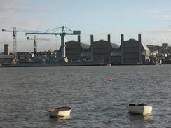
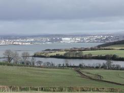
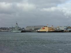
Cremyll is the place where a ferry can be caught over from Plymouth, and if I had used this option it would have cut at least a day and a half of fairly dreary walking off my schedule. I am very pleased that this section is over and done with, and it has been the only time so far that I really wish that I could have caught the ferry. The views over Plymouth Sound from Cremyll were quite nice, and I could see a Royal Navy ship being loaded across the water, and several other Navy ships were scattered around the Sound. It is quite strange to think of the people on board those ships setting sail for a potential (and likely) conflict instead of another training trip.
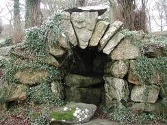
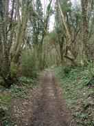
The first part of the South West Coast Path from Cremyll goes through the Mount Edgcumbe Country Park, and this was a most enjoyable section of the trip. Initially the path passes through a formal garden, and along the rest of the park there are occasional stone follies and other structures. As I was reaching the end of the path through the park I met a group of ramblers coming up in the opposite direction. The path was narrow, so I stood to one side as they passed me. As the leader passed we exchanged pleasantries, and this turned into a longer conversation. He gave me some money for the charity, and he called down to the others and out came a varied and colourful collection of wallets and purses. As everyone passed me they put money in the collection box, which made me feel rather like a path troll, demanding payment before they could pass!
The twin villages of Kingsands and Cawsands are very nice, although I did not realise when I walked from one village into the other. Until 1844 the border between Devon and Cornwall was directly in between the two villages, and one house had a marker on denoting the old boundary between the two counties. This has led me to wonder why the border was in such a strange place, when the current position of the border along the River Tamar seems to be a much more logical place.
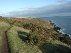
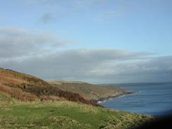
Although I say that this walked ended at Freathy, it actually ended at the Rame View Cafe, about a mile up the road. This was because Sam was waiting for me there, and I did not fancy walking on that extra little distance so late in the day. The views over towards Rame Head are very nice, and the chapel on top stood out well against the skyline. I had wanted to climb up to have a look around the chapel, but the wind was exceedingly strong and so I reluctantly decided that it was not worth the effort to reach it.
As of today I am about one-third of the way through the total walk, given the current estimated total of around 5,600 miles. This is a really nice feeling, although my next target of fifty percent of the walk completed is a long time away. Tomorrow I will probably reach as far as Looe, which promises to be another nice section of coastal walking.
Directions
| During this walk I followed the South West Coast Path, the route of which is detailed in the Ordnance Survey National Trail Guide 10, Falmouth to Exmouth (ISBN 1-854108-90-5). Unfortunately the route description is written in reverse to the direction that I am walking, but the 1:25,000 maps in the book are clear and the signs on the ground are very good. Also to be recommended is the South West Coast Path Association guidebook (ISBN 0-907055-04-4), which has less concise directions and no maps, but includes accommodation details and grades each section of the walk according to difficulty. They also publish reverse directions, which are suitable for walking in the direction that I walked the route. They have a website at www.swcp.org.uk, which is well worth a visit. | 
|
| 
| |
| |
| |
This walk starts off on the A374 road opposite the post office in Antony. Follow the A374 road as it heads eastwards out of the little village for three miles into Torpoint. After about a mile a pavement starts on the right, which makes the journey into the town safer. The road enters the town as Antony Road, and continue as it becomes Fore Street. Turn left down Quarry Road towards the sea and then turn right along the seafront and Ferry Street, beside the ferry over to Devonport. Continue along Ferry Street as it curves to the left and then becomes Marine Drive. This meets the sea once more before turning to the right and becoming Carbeile Road. Follow this road uphill until it ends at a T-junction with Trevol Road.
Turn left down Trevol Road, and follow it as it heads westwards, passing through HMS Raleigh and splitting the establishment into two. Once the tall and secure fence on the left beside the road ends turn left along a footpath that skirts the fence before turning to the right across fields to end at another road. Turn left down this road and follow it as it descends to meet the western end of St John's Lake before climbing up into the little village of St Johns. Pass the little church and continue on southwards as it climbs out of the village and continues on to the hamlet of Penhalle. Some steep road sections follow before the road curves to the right to descend into Insworke. At this bend turn right up the narrow Blindwell Hill, which descends down into the centre of the village of Millbrook.
When Blindwell Hill ends at a T-junction continue on for a few yards down Fore Street until this too ends at a T-junction with King Street. Turn left down King Street and follow it until some public toilets are reached. AT the toilets turn right down Greenland and follow this road as it skirts the southern side of a freshwater lake before a dam is reached and the road skirts the tidal Millbrook Lake. Follow this road as it curves around the edge of the lake before settling on a rough easterly course below Clarrick Woods. When the road climbs uphill away from the Lake climb uphill and then take a footpath that leads away to the left. This footpath follows he edge of fields above the lake, passing under the stump of an old windmill and skirting an old harbour before rising up a hill and then falling down into Cremyll.
Distances
| From | To | Distance (m) | Ascent (ft) | Descent (ft) |
|---|---|---|---|---|
| Antony | Cremyll | 11.2 | 1093 | 1214 |
| Cremyl | Freathy | 9.5 | 2277 | 2139 |
This makes a total distance of 20.7 miles, with 3370 feet of ascent and 3353 feet of descent.
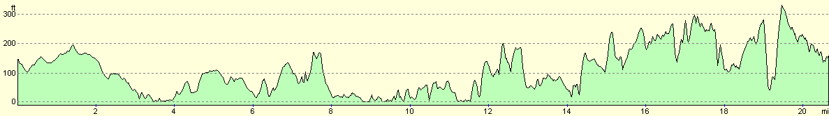
For more information on profiles, ascents and descents, see this page
Accommodation
We parked in a little lay-by beside the road just outside Freathy, which was not a bad place to park. This unfortunately means that we will have to drive back for a mile to drop me off in the morning, which is slightly annoying.
Disclaimer
Please note that I take no responsibility for anything that may happen when following these directions. If you intend to follow this route, then please use the relevant maps and check the route out before you go out. As always when walking, use common sense and you should be fine.
If you find any information on any of these routes that is inaccurate, or you wish to add anything, then please email me.
All images on this site are © of the author. Any reproduction, retransmissions, or republication of all or part of any document found on this site is expressly prohibited, unless the author has explicitly granted its prior written consent to so reproduce, retransmit, or republish the material. All other rights reserved.
Although this site includes links providing convenient direct access to other Internet sites, I do not endorse, approve, certify or make warranties or representations as to the accuracy of the information on these sites.
And finally, enjoy your walking!
This walk was mentioned in the following routes:
| My walk around the coastline of Britain |
| South West Coast Path |
Nearby walks
| # | Title | Walk length (miles) |
|---|---|---|
| 330 | Aveton Gifford to Noss Mayo | 19.1 |
| 331 | Noss Mayo to Turnchapel | 17.0 |
| 332 | Turnchapel to Saltash | 12.0 |
|
|

|