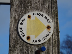
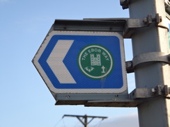
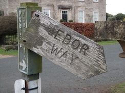
Walk #1029: Ebor Way: York to Wetherby
 |
 |
|
General Data
| Date Walked | 28/12/2018 |
| County | North Yorkshire, West Yorkshire |
| Start Location | St George's Place, York |
| End Location | Wetherby bus station |
| Start time | 07.56 |
| End time | 15.04 |
| Distance | 23.3 miles |
| Description | This was a very pleasant walk following the Ebor Way west from York, partly following the rivers Ouse and Wharfe. |
| Pack | Today I carried my 30-litre Karrimor rucksack, filled with water, my spare waterproofs, a book and other odds and ends. |
| Condition | I feel absolutely fine after this walk. |
| Weather | Today started off bright and sunny, and unseasonably warm for the time of year. Clouds started to gather around midday, and there was about an hour of light drizzle. After this ended there was a combination of sunshine and cloud. |
| OS map | Landranger number 105 (York & Selby) |
 |
 |
|
Map of the walk
Maps courtesy of Google Maps. Route for indicative purposes only, and may have been plotted after the walk. Please let me have comments on what you think of this new format. For a detailed table of timings for this walk, please see the table file.
 |
 |
|
Notes
A short post-Christmas break to York gave me an opportunity to do a walk whilst Sencan performs some important retail therapy. I did a walk from York to Selby in 2003, and that walk looks rather lonesome on my walks map, being at least thirty miles from any other walk. I had prepared two walks: one following the Ebor Way west to Wetherby, and another following the Minster Way east towards the Wolds Way. Since there are bus services from Wetherby back to York, it seemed best to do the former – although with one slight issue: the last bus of the day appeared to set off at 15.20.
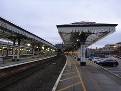
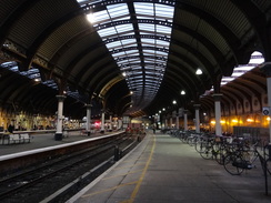
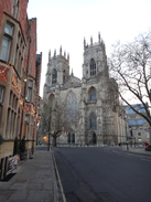
I skipped breakfast at the B&B so I could set off whilst it was still technically dark, although clear skies overhead and the streetlights gave plenty of illumination as I made my way into the city. My first target was York station, and a sign indicated a pedestrian route. I followed that road, but realised at a bridge over the railway that I'd gone the wrong way. I returned, and discovered that the pedestrian path headed through a car park and up a platform ramp to reach the station. I then headed through York to reach York Minster, where I had started my previous walk from the city.
York is a beautiful city, with a massive amount to see and do. There are more museums than you can possibly visit in a weekend, a beautiful cathedral, massive Roman city walls and beautifully higgle-piggledy city shopping streets, such as the Shambles. I could spend a few days just walking about and exploring, but today was not such an occasion.
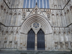
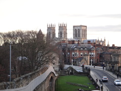
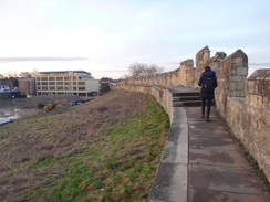
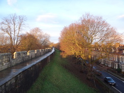
The Ebor Way passes the Minster, but several other trails pass nearby and it is difficult to see on the map which is the 'proper' route. It appears to cross the Ouse before joining the walls, and so I took that route. The walls were busy despite the early hour, with a surprising number of Chinese tourists joining joggers on the walls. As I walked along I wondered whether I preferred Chester or York's town walls: whilst Chester's are a more complete circuit, York has a little 'something' extra: perhaps it is the flat landscape giving expansive views including of the cathedral over the surrounding rooftops.
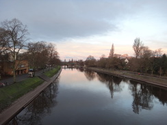
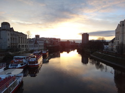
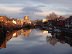
The Ouse was as flat as a millpond, with the surrounding buildings reflecting magnificently on the water's surface. The trail followed the river south, although it mostly remained out of view behind trees. A caravan site nestled inland, before the Millennium Footbridge spanned the river. After this the going became slightly harder; the path remained beside the river, but the ground was muddy; for much of the time I preferred to walk below the proper path which was badly churned up in places.
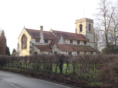
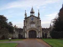
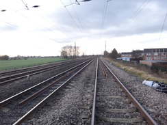
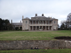
Things became better as the river curved to take a more westerly course; further away from the city and car parks, where fewer people walked or ran. Soon a low rumble from the A64 intruded, and I passed under the bridge and on to a road that led into the village of Bishopthorpe. The church was pretty enough, but it was overshadowed by an impressive gateway that leads to Bishopthorpe Palace – the home of the Archbishop of York. Aside from the gateway, not much else was visible from the road, and so I plodded on through the village, soon coming across a bridge over the old York to Selby railway line, now a cycle path that I walked fifteen years ago. The line used to be the East Coast Main Line, but concerns over settlement because of the Selby super coal mine in the 1980s caused the construction of an alternative route further west.
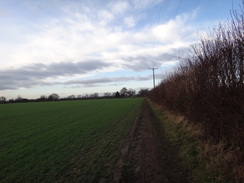
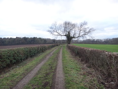
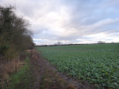
Footpaths took me west across fields to a level crossing over the railway's new route, and then on into Copmanthorpe. I took a slightly wrong incorrect route along the village's roads, but soon rejoined the correct route next to a school. A long road led southwestwards out of the village, with the A64 a sort distance away across fields. The road eventually curved away, and a footpath carried on across fields – so arrow-straight I was unsurprised to discover that it was the course of a Roman road.
The path met a road. The map showed the trail continuing on along a pavement on the southern side of the A64, but a waymarker pointed over a road bridge towards the northern side. More markers led me over the bridge to where another pavement ran alongside the main road. It seems the trail has been diverted, and if that means the dual carriageway does not need to be crossed on the level further on, then it's a diversion for the better. This was especially true for me, as the pavement led me to a roadside Greggs where I could buy a few sausage rolls to munch on.
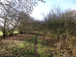
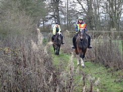
The trail eventually left the main road and headed on along something called The Old Street. This was arrow-straight as it was a continuation of the Roman road I had followed earlier. Initially this was firm underfoot, but it soon became muddy and churned up by horses' hooves – including two I soon encountered. The path met a road that took me back towards the dual carriageway, but thankfully another road took me down into Tadcaster.
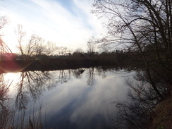
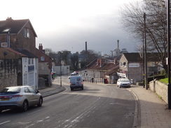
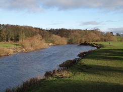
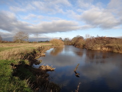
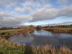
I'd like to say Tadcaster was a pleasant place, but my route through it was neither spectacular or interesting, nor drab or boring. I found little of interest on my route through the town, including the brewery that dominated the view ahead as I descended the hill. And perhaps that was for the best, as what followed was a very pleasant stretch of path alongside the River Wharfe – why overshadow such beauty?
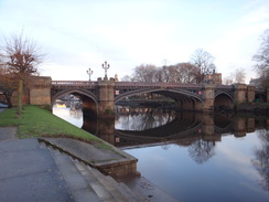
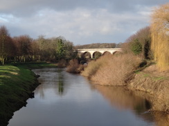
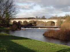
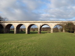
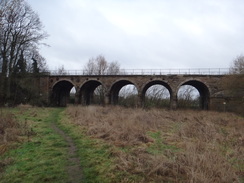
The grass along the riverside path was not muddy, and I soon came across a magnificent old railway viaduct across the river. This was built from a yellowish stone, and its only negative was that the two arches spanning the river itself had a wider span that those of the approach viaduct, spoiling the symmetry. But aside form that minor niggle, it looked superb. The viaduct itself has an interesting history: it was built by the infamous George Hudson in 1848 as part of a route between Leeds and York. Unusually the line was never completed, and the only traffic the viaduct saw was occasional trains to a mill on the river's eastern bank. Someone must have lost a great deal of money in its construction at the height of the railway mania.
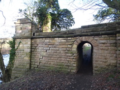
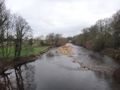
There was another little curiosity a little further on: a small stone jetty, wide and strongly-constructed, led to the river, with a small archway through it to carry the footpath underneath. There was no sign of any equivalent abutment on the other side of the river, and no trace of a bridge on the map, so I can only assume that it was a wharf for the nearby Smaws Quarry, which is believed to have provided the stone for the Norman York Minster and perhaps even the city's Roman walls. An early 20th Century map of the area does not provide much further information, but it was an impressive little structure. If that was its purpose, then it was a wharf on the Wharfe!
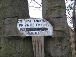
The next mile or so along the river was very pleasant, even if the clouds gathered and it started to drizzle. In sunshine it would have been a glorious stroll, but I did not mind the change in the weather. I was aware that I was short of time in which to catch my bus, so I started yomping for short distances, much to the amusement of some fishermen who stared at me as I jogged past!
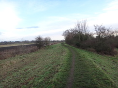
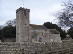
A wall blocked the river in Newton Kyme, and I followed this up past the remains of Kyme Castle, (which was barely visible), and on past a pretty little church and hall, the latter complete with ha-ha. A road took me towards a main road, and I considered diverting off the Ebor Way and taking a short cut to Boston Spa so that I could be sure to get the bus. Eventually I decided to stay on the trail, and yomped down a long and sometimes overgrown lane back to the river.
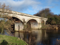
The river led to another railway viaduct over the river. This one once carried the Wetherby to Tadcaster line over the Wharfe, and was built in 1847 by George Stephenson. I was surprised to see people cycling over it, as there is no path marked on my map. The explanation is that it was opened as a path earlier this year by a company who built a nearby housing estate as part of their local obligations. The character of the path changed after the viaduct, as it headed below and over small cliffs alongside the river, and then past houses on the edge of Boston Spa.
The path reached Wharfe Bridge, which the trail crossed to head north along roads to, and through, the village of Thorp Arch. A track then led on past woodland and parked 4x4s that belonged to a jovial shooting party. By this point I was fairly confident about catching the 15.20 bus, and so I stopped yomping and started to take my time. The track ended and a path took me west for a short distance to another track which dumped me out by the side of the A1(M). My old map showed this as being the A1 dual carriageway, although the conversion to a motorway had barely altered the route.
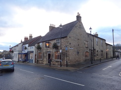
I did not get much time to study Wetherby, but I saw a few attractive stone building as I strode through. The bus station was easy to find, and an electronic display told me the bus to York was due in ten minutes. I tried to get as much mud off my boots as possible before sitting down in the shelter. The departure time came, and the bus appeared on the display as 'departed'. I looked at another nearby roadside stop to see a bus departing; I went to it, but it was for buses operating in the other direction. Confused, I headed back to the shelter where a man kindly told me that I was waiting in the correct place and that the bus was often late. It's annoying that the electronic displays appear to be governed more by the timetable than reality!
The bus arrived about ten minutes late, and after it got into York I met up with Sencan to walk back to the B&B. It had been a very enjoyable day's walk, that had only partially spoilt by the need to hurry to catch the bus. The Ebor Way may be a little known trail, but it can be rather pleasant.
 |
 |
|
Directions
This walk starts off from St George's Place in York at SE59055067. If you wish to start at York railway station or York Minster, then move on a couple of paragraphs.
Head down St George's Place, and then turn left to head northeastwards along the A1036 Tadcaster Road, with the tip of York racecourse initially across the road. After 700 metres, turn left along the A59 Holgate road, and immediately after the road curves left, turn right down Lowther Terrace. Just before this road turns left, turn right through a gap in a wall, which leads to a ramp that leads down into a car park. At the ramp's bottom, angle left to head diagonally across the car park towards York railway station. At the far corner, join a ramp that leads up onto a platform. Continue along the platform, and shortly before a footbridge is reached, curve right across the concourse to reach the station's main entrance at SE59645171.
Turn left to head under the porte-cochere. When it ends, turn right and then left to join Station road, and follow it as it crosses the A1036 Station Rise before curving right to head under York's city walls. On the other side, it curves left to parallel the wall for a short distance, before crossing Lendal Bridge over the River Ouse. On the other side the road becomes Museum Street; follow it northeastwards for 300 metres until the front of York Minster is reached at SE60245217.
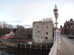
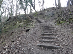
Retrace your steps by heading southwestwards down Museum Street for 300 metres until Lendal Bridge over the River Ouse is reached. Cross the bridge, and about thirty metres beyond it, turn right through a gap in a low stone wall to join a path that soon curves left to start following the city wall on the right. Follow the wall along; initially it heads southwestwards, with the railway station below to the right, before curving left to head southeastwards crossing Micklegate. It finally turns left once more and, 1.7km after joining the wall, the path descends steps to reach Skeldergate Road. Cross the road, and then turn right for a few metres to reach a T-junction. Here turn left for a few metres to reach Skeldergate Bridge at SE60345126.
Do not cross the bridge, and instead immediately turn left down some steps that lead down onto Terry Avenue. At the bottom, turn right to head under the bridge's elegant arches and continue along the road, with the river immediately to the left. After about 600 metres the road ends, and a footpath continues on alongside the river. It passes under the Millennium Footbridge, and after about 900 metres from the end of the road, the surfaced path curves right at SE60174984, whilst a firm unsurfaced path continues on with a hedge and the river on the left.
A short distance on, cross a stile into a field and continue on beside the river. You can either follow the path along the top of the floodbank, or walk in the narrow grassy gap between the bank and the river, crossing any stiles you come across between the fields. The path and river curve right to take a more westerly course, and then heads under the A34(T) dual carriageway. 450 metres after the bridge, the path curves left off the floodbank to head between the bank and the river, and then passes a stile. The path then follows the river for a few metres before curving right away from the river between fences to emerge out onto Bishopthorpe Road at SE59594817.
Turn left to follow the road south into the village; it passes the parish church on the right and then the elegant entrance to Bishopthorpe Palace on the left, and after 460 metres curves sharply right, becoming Main Street as it heads roughly westwards through the village. This road curves left next to a school, becoming Appleton Road, and soon reaches a bridge over an old railway line. Follow the road over the bridge, and then turn right down Bridge Road. After 250 metres this ends at a T-junction with Copmanthorpe Lane at SE58804748.
Turn left to head westwards along the lane; after about 650 metres it ends at a few houses on the right. In a little turning area, continue straight on along a path between a fence and a hedge. The path soon curves right and then left across a footbridge over a ditch to enter a field. In the field, turn right to parallel the ditch on the right. At the corner of the field, turn left to follow a hedge on the right. Ignore any gaps in the hedge on the right, and at the far corner of the field go through a gap in a hedge and cross a farm bridge over a stream to enter a second field at SE57774732.
Turn left along the edge of the second field for about twenty metres to its corner, and then right to continue westwards past the field. At the corner of this field, go past the end of a fence into a third field, and head on, still following the ditch on the left. The field narrows to reach Bishopthorpe crossing over a railway line at SE57124714.
Go through the gates and carefully cross the railway line, using the lights that show you when it is safe to cross. Immediately on the other side, turn left along a path that initially parallels the railway line on the left, before it passes a couple of garages on the right and reaches the end of a cul-de-sac. Turn right down this road, and when it soon ends at a T-junction, turn left along Farmers Way. This curves right; shortly after it does so, turn left down Wheel Wright Close at SE56954705.
When the road soon ends, continue along a surfaced path that turns left, following a palisade fence on the right that guards school playing fields. The path curves right past a bowls green and then tennis courts on the left, and the school on the right before emerging out onto Low Green. Turn left to follow Low Green southwestwards; it passes a church on the right, and ends at a triangular junction with Main Street in Copmanthorpe at SE56484682.
Turn right to follow Main Street northwards; after about 100 metres turn left along School Lane. This curves right to become Manor Heath, with a field to the left, and 420 metres after joining School Lane, a junction with a road on the left is reached, signposted for Colton. Turn left along this road to follow it west-southwestwards. After 1.6km it turns sharply left at SE54804625.
At the bend, turn right to pass a farm gate on the left, towards another farm gate ahead. Before the gate is reached, turn left through a pedestrian gate to enter a field. Follow a hedge on the right; at the corner of the field, squeeze past the end of a hedge to enter a second field, and at this field's corner go through another gap and continue past a third field. At the next corner, go through a gap, cross a plank footbridge over a ditch, to enter a fourth field. The path then curves right before the field ends to reach a pedestrian gate that leads out onto a road at SE53754585.
Turn right along the road, and then immediately right up another road that curves left to climb up to a bridge across the A64(T). On the other side of the bridge, turn left down some steps that lead to a path that leads tp the road's eastbound carriageway. Turn right to follow the road on the left, and then cross a road coming in from the right. Continue along the road for 1km, until a road ('The Old Street') angles off to the right at SE52814545.
Head along The Old Street; it passes some barns and becomes a track; 900 metres after the main road, it reaches some woodland on the right and becomes a path. Follow the path as it runs arrow-straight past three fields for another 1.4km, before emerging out through a field gate onto Catterton Lane at SE50734447.
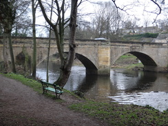
Turn left along Catterton Lane; it curves left to cross Rolling Bridge over The Foss and continues south; 380 metres after joining the lane, it ends at the A64(T). Just before the dual carriageway is reached, angle right along a path that joins a cyclepath beside the road. Follow the cycle path west; the dual carriageway slowly curves left, whilst the start of an old road forms in the gap between dual carriageway and path. This old road soon becomes a public road, which in turn becomes the A659. Follow this westwards into Tadcaster for 2km, until Tadcaster Bridge over the River Wharfe is reached at SE48754345.
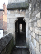
Cross the bridge, and immediately on the other (western) side, turn hard right to join a grassy path that initially runs between houses and a floodbank, and then the village church away to the left. The path passes a weir on the right to reach a clappergate that leads onto the floodplain, and continue following the river on the right towards an old railway viaduct ahead. Pass under the viaduct; continue alongside the river as the path climbs slightly to pass a little stone building (a gauging station) to reach a tiny little stone archway. Pass through the archway and continue on as the river curves right. A couple of stone steps at a wall are soon reached at SE47534402. Climb the steps, and once on top of the wall, turn right to cross a bridge over a stream. At the far side go through a pedestrian gate to rejoin the riverside path.
Continue along the riverside path as the river winds upstream. At the end of this large field, go through a bridleway gate and cross a little bridge over a stream to reach a second bridleway gate. On the other side, the riverside path continue on past a second field to reach a clappergate that leads into a third field. As the path approaches a fence ahead, turn left to head up away from the river; the fence soon becomes a wall before becoming a fence once more. They wind around slightly; the path then curves right to follow a hedge on the right. It passes Newton Kyme church and then a ha-ha in front of a hall on the right, to reach a field gate that leads onto Croft Lane in Newton Kyme at SE46444487.
Turn left along this road; when it soon reaches a triangular junction, head straight on. After 700 metres the road meets the A659 road. Turn right to follow the road westwards; there is a pavement on the right. After 450 metres a lane comes in from the left on the other side of the road; a few metres beyond this junction, turn right up a track that runs north between hedges. It becomes narrower and very overgrown before it descends to rejoin the southern bank of the Wharfe at SE45264559.
At the river, the path curves left to reach a stile. Cross the stile and continue on, following the river upstream on the right. The path passes under an old railway viaduct; shortly after this, go through a clappergate and continue following the river on the right. The path climbs up above the river, squeezes between an industrial fence on the left and a wooden fence on the right, and then descends some steps. At the bottom go through a clappergate and continue along the path as the river curves right. At the end of this field, the path veers left slightly away from the river to reach a footbridge guarded by clappergates at SE44174522.
Go through these and follow the path as it angles back towards the river. Immediately after passing under some power lines, go through a clappergate and continue along the path, with the river still to the right. The path becomes a track, between houses on a hillside in Boston Spa. After passing between gateposts, angle left up a track uphill, which leads out into a bridge over the river at SE43164571.
Turn right to cross the bridge, and follow the road as it heads north into and through the little village of Thorp Arch. The road leaves the village; 1.3km after the bridge, turn left along a green track that runs between hedges. Initially this heads westwards, before turning right and then curving left past woodland. The track curves right once more to head north away from the woodland, and then left to descend down to meet a surfaced track at SE42474735.
Head straight on along the surfaced track as it climbs to pass the buildings of Flint Mill Grange. When the track curves right immediately past the farm, continue straight on along a path that enters a field. Follow the field boundary on the left; at the end of this field, go through a gap in a hedge ahead into a second field. Follow a hedge and then a fence on the left; at the end of this field it reaches a surfaced lane called Watersole Lane at SE41534735.
Cross the lane and continue straight on along a bridleway that runs between hedges. This curves right and then left before emerging onto a track above the A1(M). Turn right along the new track, paralleling the A1(M) on the left; it soon curves right and ends at Walton Road at SE41204792.
Carefully cross the road to reach the pavement on the other side, and then turn left to follow the road to a bridge over the A1(M) and on to a roundabout on the other side. Carefully cross the roundabout to head straight on, still following Walton Road. The road heads into the centre of Wetherby; when it curves sharply to the right 500 metres after the roundabout, take the second road off to the left on the bend, Horsefair. This passes shops and ends at High Street. Turn left to head south down High Street, and when a roundabout is reached, turn right for a few metres to reach Wetherby bus station on the left at SE40384808.
 |
 |
|
Distances
| From | To | Distance (m) | Ascent (ft) | Descent (ft) |
|---|---|---|---|---|
| St George's Place, York | York Minster | 1.9 | 92 | 75 |
| York Minster | Copmanthorpe | 6.7 | 154 | 138 |
| Copmanthorpe | Tadcaster | 6.0 | 154 | 187 |
| Tadcaster | Boston Spa | 5.3 | 79 | 79 |
| Boston Spa | wetherby bus station | 3.4 | 167 | 112 |
This makes a total distance of 23.3 miles, with 646 feet of ascent and 591 feet of descent.
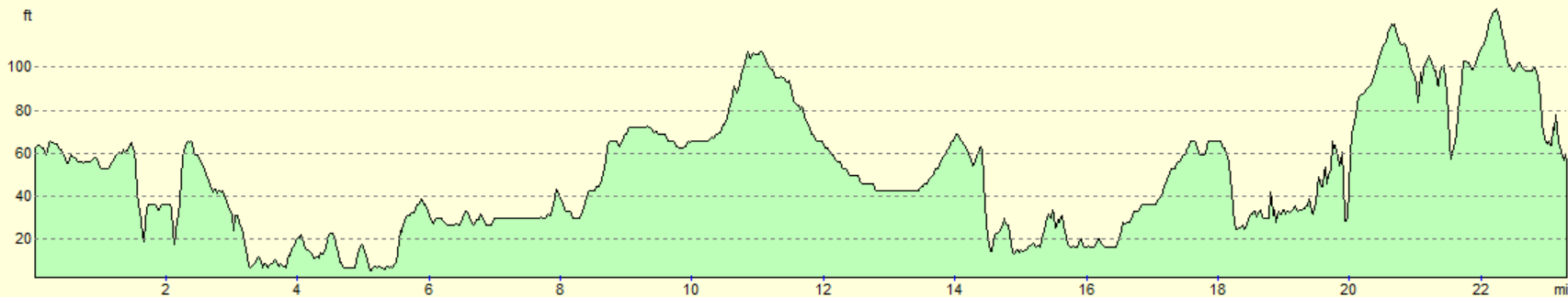
For more information on profiles, ascents and descents, see this page
Transport
Bus service 412 runs several times a day between Wetherby and York, as part of a service between Harrogate and York.
 |
 |
|
 |
 |
|
 |
 |
|
 |
 |
|
 |
 |
|
 |
 |
|
 |
 |
|
 |
 |
|
 |
 |
|
 |
 |
|
 |
 |
|
 |
 |
|
 |
 |
|
 |
 |
|
 |
 |
|
 |
 |
|
 |
 |
|
 |
 |
|
 |
 |
|
 |
 |
|
Disclaimer
Please note that I take no responsibility for anything that may happen when following these directions. If you intend to follow this route, then please use the relevant maps and check the route out before you go out. As always when walking, use common sense and you should be fine.
If you find any information on any of these routes that is inaccurate, or you wish to add anything, then please email me.
All images on this site are © of the author. Any reproduction, retransmissions, or republication of all or part of any document found on this site is expressly prohibited, unless the author has explicitly granted its prior written consent to so reproduce, retransmit, or republish the material. All other rights reserved.
Although this site includes links providing convenient direct access to other Internet sites, I do not endorse, approve, certify or make warranties or representations as to the accuracy of the information on these sites.
And finally, enjoy your walking!
Nearby walks
| # | Title | Walk length (miles) |
|---|---|---|
| 568 | York to Selby | 15.2 |
|
|

|